Bridge Statistics for Rincon, New Mexico (NM)
Condition, Traffic, Stress, Structural Evaluation, Project Costs
- National Bridge Inventory (NBI) Statistics
- 14Number of bridges
- 157ft / 47.8mTotal length
- $860,000Total costs
- 44,449Total average daily traffic
- 15,487Total average daily truck traffic
- National Bridge Inventory (NBI) Registered Bridges for Rincon
- No street view available for this location
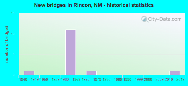
- New bridges - historical statistics
- 11940-1949
- 111960-1969
- 11970-1979
- 12010-2019


- Bridge Condition - Deck
- 57.1%Good
- 28.6%Satisfactory
- 14.3%Poor

- Bridge Condition - Superstructure
- 57.1%Good
- 28.6%Satisfactory
- 14.3%Serious

- Bridge Condition - Substructure
- 42.9%Good
- 42.9%Satisfactory
- 14.3%Fair

- Bridge Condition - Channel
- 12.5%Very good
- 25.0%Good
- 37.5%Satisfactory
- 25.0%Poor

- Bridge Condition - Culverts
- 50.0%Satisfactory
- 25.0%Fair
- 25.0%Poor
Find on map >> Show street view
Structure Number: 5575, Location: 2.7 MI E OF JCT NM-185 (Lat: 32.669769, Lng: -107.102933), Route carried "on" structure: State highway 154, Year Built: 1947, Status: Open, Structure Length: 1.02m (3.35ft), Average Daily Traffic: 738 (year 2020), Truck Traffic: 16%, Average Future Daily Traffic: 1,380 (year 2040), Design Load: HS 20, Features Intersected: UNNAMED WATERWAY
Minimum Vertical Clearance: 30+ m (98+ ft), Kilometerpoint: 4.345, Lanes on structure: 2, Owner: State Highway Agency, Approaching Roadway Width: 7.6m (24.9ft), Material/Design: Concrete continuous, Design/Construction: Culvert, Number Of Spans In Main Unit: 4, Length of Maximum Span: 2.4m (7.9ft)
Condition: Channel: Poor, Culverts: Fair, Operating Rating: 55.5 metric tons, Method Used To Determine Operating Rating: Load Factor (LF), Inventory Rating: 32.7 metric tons, Method Used To Determine Inventory Rating: Load Factor (LF), Structural Evaluation: Somewhat better than minimum adequacy, Waterway Adequacy: Meets minimum limits, Approach Roadway Alignment: Better than present minimum criteria, Designated Inspection Frequency: Every 24 months, Inspection Date: Febuary 2022
Find on map >> Show street view
Structure Number: 6458, Location: 0.2 M S Jct NM-140/I-25 (Lat: 32.675283, Lng: -107.052294), Route carried "on" structure: Interstate 25, Year Built: 1964, Year Reconstructed: 1996, Status: Open, Structure Length: 6.52m (21.39ft), Average Daily Traffic: 6,508 (year 2020), Truck Traffic: 37%, Average Future Daily Traffic: 11,142 (year 2040), Design Load: HS 20, Features Intersected: Rincon Arroyo
Minimum Vertical Clearance: 30+ m (98+ ft), Kilometerpoint: 56.858, Lanes on structure: 2, Base Highway Network: Yes, Owner: State Highway Agency, Approaching Roadway Width: 12.2m (40.0ft), Skew: 3 degrees, Material/Design: Steel continuous, Design/Construction: Stringer/Multi-beam, Number Of Spans In Main Unit: 3, Length of Maximum Span: 25.0m (82.0ft), Curb-To-Curb Width: 11.7m (38.4ft), Out-to-Out Width: 12.6m (41.3ft)
Condition: Deck: Good, Superstructure: Good, Substructure: Good, Channel: Good, Operating Rating: 48.3 metric tons, Method Used To Determine Operating Rating: Load Factor (LF), Inventory Rating: 28.8 metric tons, Method Used To Determine Inventory Rating: Load Factor (LF), Structural Evaluation: Better than present minimum criteria, Deck Geometry: Equal to present minimum criteria, Waterway Adequacy: Equal to present desirable criteria, Approach Roadway Alignment: Equal to present desirable criteria, Designated Inspection Frequency: Every 24 months, Inspection Date: May 2020, Deck Structure Type: Concrete Cast-file-Place, Wearing Surface/Protective System: Wearing Surface: Latex Concrete, Deck Protection: Epoxy Coated Reinforcing
Find on map >> Show street view
Structure Number: 6459, Location: 29.5 Mi N of Jct US-70 (Lat: 32.675936, Lng: -107.056103), Route carried "on" structure: Interstate 25, Year Built: 1964, Year Reconstructed: 1996, Status: Open, Structure Length: 10.58m (34.71ft), Average Daily Traffic: 6,508 (year 2020), Truck Traffic: 37%, Average Future Daily Traffic: 11,142 (year 2040), Design Load: HS 20, Features Intersected: NM-140 and BNSF R/R
Minimum Vertical Clearance: 30+ m (98+ ft), Kilometerpoint: 57.196, Lanes on structure: 2, Lanes under structure: 2, Base Highway Network: Yes, Owner: State Highway Agency, Approaching Roadway Width: 12.0m (39.4ft), Skew: 4 degrees, Material/Design: Steel continuous, Design/Construction: Stringer/Multi-beam, Number Of Spans In Main Unit: 6, Length of Maximum Span: 21.0m (68.9ft), Curb-To-Curb Width: 11.7m (38.4ft), Out-to-Out Width: 12.6m (41.3ft)
Condition: Deck: Good, Superstructure: Good, Substructure: Good, Operating Rating: 44.7 metric tons, Method Used To Determine Operating Rating: Load Factor (LF), Inventory Rating: 26.8 metric tons, Method Used To Determine Inventory Rating: Load Factor (LF), Structural Evaluation: Equal to present minimum criteria, Deck Geometry: Equal to present minimum criteria, Underclear: Somewhat better than minimum adequacy, Approach Roadway Alignment: Equal to present desirable criteria, Designated Inspection Frequency: Every 24 months, Inspection Date: May 2020, Deck Structure Type: Concrete Cast-file-Place, Wearing Surface/Protective System: Wearing Surface: Latex Concrete, Deck Protection: Epoxy Coated Reinforcing
Find on map >> Show street view
Structure Number: 6738, Location: 26.8 MI N OF JCT US-70 (Lat: 32.671447, Lng: -107.010361), Route carried "on" structure: Interstate 25, Year Built: 1966, Status: Open, Structure Length: 0.77m (2.53ft), Average Daily Traffic: 6,508 (year 2020), Truck Traffic: 37%, Average Future Daily Traffic: 11,142 (year 2040), Design Load: HS 20, Features Intersected: LOCAL ROAD
Minimum Vertical Clearance: 30+ m (98+ ft), Kilometerpoint: 52.867, Lanes on structure: 4, Lanes under structure: 2, Base Highway Network: Yes, Owner: State Highway Agency, Approaching Roadway Width: 22.5m (73.8ft), Skew: 20 degrees, Material/Design: Concrete, Design/Construction: Culvert, Number Of Spans In Main Unit: 1, Length of Maximum Span: 7.7m (25.3ft), Out-to-Out Width: 22.6m (74.1ft)
Condition: Culverts: Satisfactory, Operating Rating: 73.5 metric tons, Method Used To Determine Operating Rating: Load Factor (LF), Inventory Rating: 32.7 metric tons, Method Used To Determine Inventory Rating: Load Factor (LF), Structural Evaluation: Equal to present minimum criteria, Underclear: High priority of corrective action, Approach Roadway Alignment: Equal to present desirable criteria, Length Of Structure Improvement: 0.76m (2.49ft), Designated Inspection Frequency: Every 24 months, Inspection Date: September 2021, Bridge Improvement Cost: $193,000, Roadway Improvement Cost: $19,000, Total Project Cost: $289,000 ( Estimate for 2030)
Find on map >> Show street view
Structure Number: 6755, Location: 0.2 M S Jct NM-140/I-25 (Lat: 32.675053, Lng: -107.052525), Route carried "on" structure: Interstate 25, Year Built: 1966, Year Reconstructed: 1996, Status: Open, Structure Length: 6.52m (21.39ft), Average Daily Traffic: 6,508 (year 2020), Truck Traffic: 37%, Average Future Daily Traffic: 11,142 (year 2040), Design Load: HS 20, Features Intersected: Rincon Arroyo
Minimum Vertical Clearance: 30+ m (98+ ft), Kilometerpoint: 56.858, Lanes on structure: 2, Base Highway Network: Yes, Owner: State Highway Agency, Approaching Roadway Width: 11.7m (38.4ft), Skew: 3 degrees, Material/Design: Steel continuous, Design/Construction: Stringer/Multi-beam, Number Of Spans In Main Unit: 3, Length of Maximum Span: 25.0m (82.0ft), Curb-To-Curb Width: 11.5m (37.7ft), Out-to-Out Width: 12.6m (41.3ft)
Condition: Deck: Good, Superstructure: Good, Substructure: Satisfactory, Channel: Good, Operating Rating: 49.8 metric tons, Method Used To Determine Operating Rating: Load Factor (LF), Inventory Rating: 29.7 metric tons, Method Used To Determine Inventory Rating: Load Factor (LF), Structural Evaluation: Equal to present minimum criteria, Deck Geometry: Somewhat better than minimum adequacy, Waterway Adequacy: Equal to present desirable criteria, Approach Roadway Alignment: Equal to present desirable criteria, Designated Inspection Frequency: Every 24 months, Inspection Date: May 2020, Deck Structure Type: Concrete Cast-file-Place
Find on map >> Show street view
Structure Number: 6756, Location: 29.5 Mi N of Jct US-70 (Lat: 32.675733, Lng: -107.056431), Route carried "on" structure: Interstate 25, Year Built: 1966, Year Reconstructed: 1996, Status: Open, Structure Length: 11.92m (39.11ft), Average Daily Traffic: 6,508 (year 2020), Truck Traffic: 37%, Average Future Daily Traffic: 11,142 (year 2040), Design Load: HS 20, Features Intersected: NM-140 & BNSF R/R
Minimum Vertical Clearance: 30+ m (98+ ft), Kilometerpoint: 57.196, Lanes on structure: 2, Lanes under structure: 2, Base Highway Network: Yes, Owner: State Highway Agency, Approaching Roadway Width: 13.1m (43.0ft), Skew: 2 degrees, Material/Design: Prestressed concrete, Design/Construction: Stringer/Multi-beam, Number Of Spans In Main Unit: 6, Length of Maximum Span: 24.4m (80.1ft), Curb-To-Curb Width: 12.0m (39.4ft), Out-to-Out Width: 13.3m (43.6ft)
Condition: Deck: Good, Superstructure: Good, Substructure: Satisfactory, Operating Rating: 53.5 metric tons, Method Used To Determine Operating Rating: Load Factor (LF), Inventory Rating: 32.4 metric tons, Method Used To Determine Inventory Rating: Load Factor (LF), Structural Evaluation: Equal to present minimum criteria, Deck Geometry: Equal to present minimum criteria, Underclear: Meets minimum limits, Approach Roadway Alignment: Equal to present desirable criteria, Designated Inspection Frequency: Every 24 months, Inspection Date: May 2020, Deck Structure Type: Concrete Cast-file-Place, Wearing Surface/Protective System: Wearing Surface: Latex Concrete, Deck Protection: Epoxy Coated Reinforcing
Find on map >> Show street view
Structure Number: 6866, Location: 3.8 MI S OF NM-26 (Lat: 32.676600, Lng: -107.090000), Route carried "on" structure: Interstate 25, Year Built: 1966, Status: Open, Structure Length: 0.99m (3.25ft), Average Daily Traffic: 7,710 (year 2020), Truck Traffic: 37%, Average Future Daily Traffic: 13,198 (year 2040), Design Load: HS 20, Features Intersected: UNNAMED WATERWAY
Minimum Vertical Clearance: 30+ m (98+ ft), Kilometerpoint: 60.399, Lanes on structure: 4, Base Highway Network: Yes, Owner: State Highway Agency, Approaching Roadway Width: 23.1m (75.8ft), Skew: 21 degrees, Material/Design: Concrete continuous, Design/Construction: Culvert, Number Of Spans In Main Unit: 3, Length of Maximum Span: 3.0m (9.8ft)
Condition: Channel: Poor, Culverts: Poor, Operating Rating: 44.1 metric tons, Method Used To Determine Operating Rating: Load Factor (LF), Inventory Rating: 32.7 metric tons, Method Used To Determine Inventory Rating: Load Factor (LF), Structural Evaluation: Meets minimum limits, Waterway Adequacy: Equal to present desirable criteria, Approach Roadway Alignment: Equal to present desirable criteria, Designated Inspection Frequency: Every 12 months, Inspection Date: January 2022
Find on map >> Show street view
Structure Number: 7715, Location: 0.3 M E JCT NM154/NM140 (Lat: 32.667194, Lng: -107.072550), Route carried "on" structure: County highway 13018, Year Built: 1970, Status: Open, Structure Length: 1.73m (5.68ft), Average Daily Traffic: 270 (year 2020), Average Future Daily Traffic: 498 (year 2040), Features Intersected: UNNAMED WATERWAY, Facility Carried by Structure: 13-Z018
Minimum Vertical Clearance: 30+ m (98+ ft), Kilometerpoint: 0.002, Lanes on structure: 2, Owner: County Highway Agency, Approaching Roadway Width: 5.5m (18.0ft), Material/Design: Steel continuous, Design/Construction: Stringer/Multi-beam, Number Of Spans In Main Unit: 2, Length of Maximum Span: 8.4m (27.6ft), Curb-To-Curb Width: 5.9m (19.4ft), Out-to-Out Width: 6.2m (20.3ft)
Condition: Deck: Satisfactory, Superstructure: Satisfactory, Substructure: Good, Channel: Satisfactory, Operating Rating: 39.2 metric tons, Method Used To Determine Operating Rating: Load Factor (LF), Inventory Rating: 26.1 metric tons, Method Used To Determine Inventory Rating: Load Factor (LF), Structural Evaluation: Equal to present minimum criteria, Deck Geometry: High priority of corrective action, Waterway Adequacy: Somewhat better than minimum adequacy, Approach Roadway Alignment: Equal to present minimum criteria, Length Of Structure Improvement: 1.74m (5.71ft), Designated Inspection Frequency: Every 24 months, Inspection Date: March 2021, Bridge Improvement Cost: $46,000, Roadway Improvement Cost: $4,000, Total Project Cost: $69,000 ( Estimate for 2030), Deck Structure Type: Wood or Timber, Wearing Surface/Protective System: Wearing Surface: Bituminous
Find on map >> Show street view
Structure Number: 7716, Location: .13 M S NM154 @ MP 2.2 (Lat: 32.667106, Lng: -107.110139), Route carried "on" structure: County highway 13019, Year Built: 1962, Status: Open, Structure Length: 0.67m (2.20ft), Average Daily Traffic: 270 (year 2020), Average Future Daily Traffic: 498 (year 2040), Features Intersected: RINCON CANAL, Facility Carried by Structure: 13-Z019
Minimum Vertical Clearance: 30+ m (98+ ft), Kilometerpoint: 0.000, Lanes on structure: 1, Owner: County Highway Agency, Approaching Roadway Width: 3.7m (12.1ft), Material/Design: Prestressed concrete, Design/Construction: Tee Beam, Number Of Spans In Main Unit: 1, Length of Maximum Span: 6.4m (21.0ft), Curb-To-Curb Width: 4.5m (14.8ft), Out-to-Out Width: 5.1m (16.7ft)
Condition: Deck: Satisfactory, Superstructure: Satisfactory, Substructure: Satisfactory, Channel: Very good, Operating Rating: 50.6 metric tons, Method Used To Determine Operating Rating: Load Factor (LF), Inventory Rating: 32.7 metric tons, Method Used To Determine Inventory Rating: Load Factor (LF), Structural Evaluation: Equal to present minimum criteria, Deck Geometry: High priority of replacement, Waterway Adequacy: Equal to present desirable criteria, Approach Roadway Alignment: Equal to present minimum criteria, Length Of Structure Improvement: 0.67m (2.20ft), Designated Inspection Frequency: Every 24 months, Inspection Date: December 2020, Bridge Improvement Cost: $14,000, Roadway Improvement Cost: $1,000, Total Project Cost: $21,000 ( Estimate for 2030), Deck Structure Type: Other, Wearing Surface/Protective System: Wearing Surface: Bituminous
Find on map >> Show street view
Structure Number: 7721, Location: .55 MI S OF NM140@MP 0.8 (Lat: 32.657192, Lng: -107.068978), Route carried "on" structure: County highway 13393, Year Built: 1964, Status: Open, Structure Length: 3.71m (12.17ft), Average Daily Traffic: 270 (year 2020), Average Future Daily Traffic: 498 (year 2040), Features Intersected: UNNAMED WATERWAY, Facility Carried by Structure: 13-E393
Minimum Vertical Clearance: 30+ m (98+ ft), Kilometerpoint: 0.000, Lanes on structure: 2, Owner: County Highway Agency, Approaching Roadway Width: 6.7m (22.0ft), Material/Design: Prestressed concrete, Design/Construction: Tee Beam, Number Of Spans In Main Unit: 4, Length of Maximum Span: 9.1m (29.9ft), Curb or Sidewalk Widths: Left: 0.2m (0.7ft), Right: 0.2m (0.7ft), Curb-To-Curb Width: 7.0m (23.0ft), Out-to-Out Width: 7.6m (24.9ft)
Condition: Deck: Poor, Superstructure: Serious, Substructure: Fair, Channel: Satisfactory, Operating Rating: 42.5 metric tons, Method Used To Determine Operating Rating: Load Factor (LF), Inventory Rating: 27.8 metric tons, Method Used To Determine Inventory Rating: Load Factor (LF), Structural Evaluation: High priority of corrective action, Deck Geometry: Meets minimum limits, Waterway Adequacy: Equal to present desirable criteria, Approach Roadway Alignment: Equal to present desirable criteria, Length Of Structure Improvement: 3.72m (12.20ft), Designated Inspection Frequency: Every 6 months, Inspection Date: January 2022, Bridge Improvement Cost: $121,000, Roadway Improvement Cost: $12,000, Total Project Cost: $181,000 ( Estimate for 2030), Deck Structure Type: Concrete Cast-file-Place, Wearing Surface/Protective System: Wearing Surface: Bituminous
Find on map >> Show street view
Structure Number: 9546, Location: 17.8 Mi N of NM-185 (Lat: 32.654269, Lng: -107.096433), Route carried "on" structure: State highway 185, Year Built: 2011, Status: Open, Structure Length: 3.41m (11.19ft), Average Daily Traffic: 1,213 (year 2020), Truck Traffic: 21%, Average Future Daily Traffic: 1,042 (year 2040), Design Load: HS 20, Features Intersected: Angustora Arroyo
Minimum Vertical Clearance: 30+ m (98+ ft), Kilometerpoint: 50.485, Lanes on structure: 2, Owner: State Highway Agency, Approaching Roadway Width: 8.8m (28.9ft), Material/Design: Concrete continuous, Design/Construction: Culvert, Number Of Spans In Main Unit: 8, Length of Maximum Span: 3.7m (12.1ft)
Condition: Channel: Satisfactory, Culverts: Satisfactory, Operating Rating: 53.9 metric tons, Method Used To Determine Operating Rating: Load Factor (LF), Inventory Rating: 32.7 metric tons, Method Used To Determine Inventory Rating: Load Factor (LF), Structural Evaluation: Equal to present minimum criteria, Waterway Adequacy: Better than present minimum criteria, Approach Roadway Alignment: Equal to present minimum criteria, Length Of Structure Improvement: 6.10m (20.01ft), Designated Inspection Frequency: Every 24 months, Inspection Date: May 2021, Bridge Improvement Cost: $150,000, Roadway Improvement Cost: $50,000, Total Project Cost: $300,000 ( Estimate for 2070)
Find on map >> Show street view
Structure Number: 6459, Location: 29.5 Mi N of Jct US-70 (Lat: 32.675936, Lng: -107.056103), Route carried "under" structure: State highway 140, Year Built: 1964, Structure Length: 0. m, Average Daily Traffic: 687 (year 2020), Truck Traffic: 16%, Features Intersected: NM-140 and BNSF R/R, Facility Carried by Structure: I-25 NB
Minimum Vertical Clearance: 4.61m (15.12ft), Kilometerpoint: 4.426, Lanes on structure: 2, Lanes under structure: 2, Material/Design: Steel continuous, Design/Construction: Stringer/Multi-beam, Length of Maximum Span: 21.0m (68.9ft)
Find on map >> Show street view
Structure Number: 6738, Location: 26.8 MI N OF JCT US-70 (Lat: 32.671447, Lng: -107.010361), Route carried "under" structure: State highway 13000, Year Built: 1966, Structure Length: 0. m, Average Daily Traffic: 64 (year 2020), Truck Traffic: 17%, Features Intersected: LOCAL ROAD, Facility Carried by Structure: I-25 NB/SB
Minimum Vertical Clearance: 4.24m (13.91ft), Kilometerpoint: 0.000, Lanes on structure: 4, Lanes under structure: 2, Material/Design: Concrete, Design/Construction: Culvert, Length of Maximum Span: 7.7m (25.3ft)
Find on map >> Show street view
Structure Number: 6756, Location: 29.5 Mi N of Jct US-70 (Lat: 32.675733, Lng: -107.056431), Route carried "under" structure: State highway 140, Year Built: 1966, Structure Length: 0. m, Average Daily Traffic: 687 (year 2020), Truck Traffic: 16%, Features Intersected: NM-140 & BNSF R/R, Facility Carried by Structure: I-25 SBL
Minimum Vertical Clearance: 5.33m (17.49ft), Kilometerpoint: 4.506, Lanes on structure: 2, Lanes under structure: 2, Material/Design: Prestressed concrete, Design/Construction: Stringer/Multi-beam, Length of Maximum Span: 24.4m (80.1ft)