Bridge Statistics for Ridgefield, New Jersey (NJ)
Condition, Traffic, Stress, Structural Evaluation, Project Costs
- National Bridge Inventory (NBI) Statistics
- 32Number of bridges
- 728ft / 222mTotal length
- $5,076,000Total costs
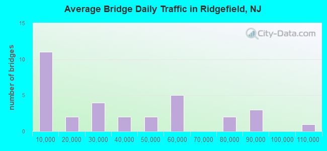
- 1,113,861Total average daily traffic
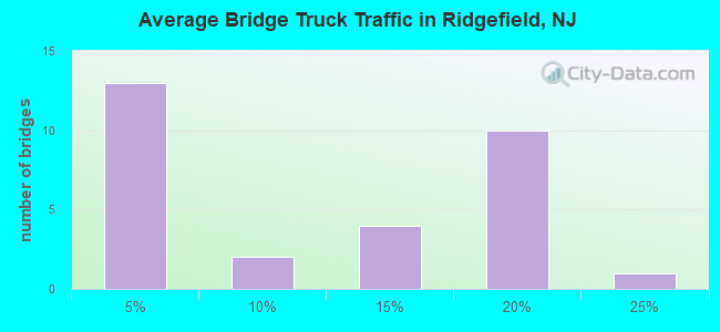
- 125,942Total average daily truck traffic
- National Bridge Inventory (NBI) Registered Bridges for Ridgefield
- No street view available for this location
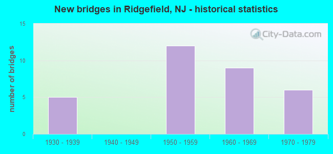
- New bridges - historical statistics
- 51930-1939
- 121950-1959
- 91960-1969
- 61970-1979
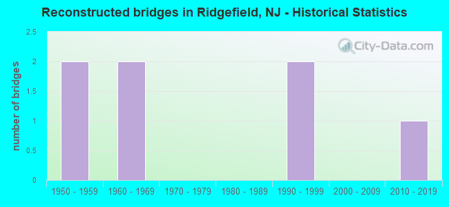
- Reconstructed bridges - Historical Statistics
- 21950-1959
- 21960-1969
- 01970-1979
- 01980-1989
- 21990-1999
- 02000-2009
- 12010-2019
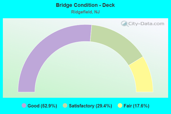
- Bridge Condition - Deck
- 52.9%Good
- 29.4%Satisfactory
- 17.6%Fair
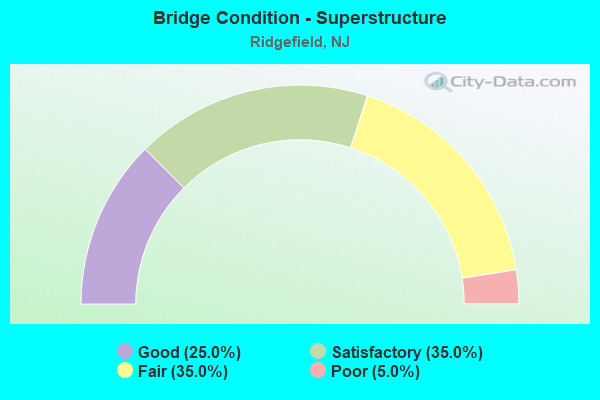
- Bridge Condition - Superstructure
- 25.0%Good
- 35.0%Satisfactory
- 35.0%Fair
- 5.0%Poor
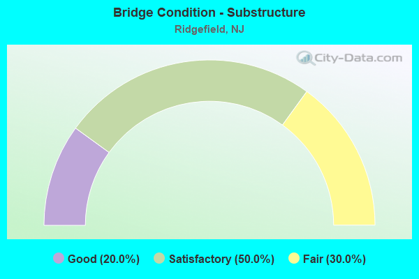
- Bridge Condition - Substructure
- 20.0%Good
- 50.0%Satisfactory
- 30.0%Fair
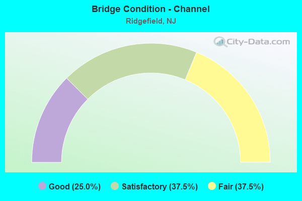
- Bridge Condition - Channel
- 25.0%Good
- 37.5%Satisfactory
- 37.5%Fair
Find on map >> Show street view
Structure Number: 20049A, Location: 0.606 MI W. of US 1&9 (Lat: 40.838600, Lng: -74.017031), Route carried "on" structure: County highway 124I, Year Built: 1963, Year Reconstructed: 2010, Status: Open, Structure Length: 10.91m (35.79ft), Average Daily Traffic: 16,970 (year 2020), Truck Traffic: 4%, Average Future Daily Traffic: 20,370 (year 2040), Design Load: HS 20, Features Intersected: OVERPECK CREEK
Minimum Vertical Clearance: 30+ m (98+ ft), Kilometerpoint: 0.975, Lanes on structure: 2, Owner: County Highway Agency, Approaching Roadway Width: 9.8m (32.2ft), Material/Design: Prestressed concrete, Design/Construction: Slab, Number Of Spans In Main Unit: 10, Length of Maximum Span: 11.9m (39.0ft), Curb or Sidewalk Widths: Left: 0.0m, Right: 1.2m (3.9ft), Curb-To-Curb Width: 9.8m (32.2ft), Out-to-Out Width: 10.8m (35.4ft)
Condition: Deck: Good, Superstructure: Satisfactory, Substructure: Good, Channel: Good, Operating Rating: 44.5 metric tons, Method Used To Determine Operating Rating: Load Factor (LF), Inventory Rating: 26.3 metric tons, Method Used To Determine Inventory Rating: Load Factor (LF), Structural Evaluation: Equal to present minimum criteria, Deck Geometry: Meets minimum limits, Waterway Adequacy: Better than present minimum criteria, Approach Roadway Alignment: Equal to present minimum criteria, Designated Inspection Frequency: Every 24 months, Underwater Inspection Frequency: Every 48 months, Inspection Date: April 2020, Underwater Inspection Date: May 2020, Deck Structure Type: Concrete Cast-file-Place, Wearing Surface/Protective System: Wearing Surface: Monolithic Concrete, Deck Protection: Galvanized Reinforcing
Find on map >> Show street view
Structure Number: 20049B, Location: 1600' East of Route 1 (Lat: 40.827161, Lng: -74.005069), Route carried "on" structure: City street , Year Built: 1956, Status: Open, Structure Length: 0.94m (3.08ft), Average Daily Traffic: 1,293 (year 2020), Truck Traffic: 1%, Average Future Daily Traffic: 1,551 (year 2040), Features Intersected: WOLF CREEK, Facility Carried by Structure: ELITE COURT
Minimum Vertical Clearance: 30+ m (98+ ft), Kilometerpoint: 0.000, Lanes on structure: 2, Owner: County Highway Agency, Approaching Roadway Width: 9.1m (29.9ft), Skew: 1 degrees, Material/Design: Concrete, Design/Construction: Slab, Number Of Spans In Main Unit: 1, Length of Maximum Span: 7.9m (25.9ft), Curb or Sidewalk Widths: Left: 2.7m (8.9ft), Right: 2.7m (8.9ft), Curb-To-Curb Width: 9.1m (29.9ft), Out-to-Out Width: 15.1m (49.5ft)
Condition: Deck: Good, Superstructure: Good, Substructure: Good, Channel: Satisfactory, Operating Rating: 55.3 metric tons, Method Used To Determine Operating Rating: Load Factor (LF), Inventory Rating: 32.7 metric tons, Method Used To Determine Inventory Rating: Load Factor (LF), Structural Evaluation: Better than present minimum criteria, Deck Geometry: Somewhat better than minimum adequacy, Waterway Adequacy: Better than present minimum criteria, Approach Roadway Alignment: Equal to present desirable criteria, Designated Inspection Frequency: Every 24 months, Inspection Date: April 2020, Deck Structure Type: Concrete Cast-file-Place, Wearing Surface/Protective System: Wearing Surface: Monolithic Concrete
Find on map >> Show street view
Structure Number: 20049C, Location: 1 Mile East of I-95 (Lat: 40.828350, Lng: -74.003919), Route carried "on" structure: City street , Year Built: 1958, Status: Open, Structure Length: 0.70m (2.30ft), Average Daily Traffic: 616 (year 2020), Truck Traffic: 1%, Average Future Daily Traffic: 740 (year 2040), Design Load: HS 20, Features Intersected: WOLF CREEK, Facility Carried by Structure: HAMILTON STREET
Minimum Vertical Clearance: 30+ m (98+ ft), Kilometerpoint: 0.000, Lanes on structure: 2, Owner: County Highway Agency, Approaching Roadway Width: 7.3m (24.0ft), Material/Design: Concrete, Design/Construction: Slab, Number Of Spans In Main Unit: 1, Length of Maximum Span: 6.7m (22.0ft), Curb or Sidewalk Widths: Left: 2.1m (6.9ft), Right: 2.1m (6.9ft), Curb-To-Curb Width: 7.4m (24.3ft), Out-to-Out Width: 12.2m (40.0ft)
Condition: Deck: Satisfactory, Superstructure: Satisfactory, Substructure: Good, Channel: Fair, Operating Rating: 57.2 metric tons, Method Used To Determine Operating Rating: Load Factor (LF), Inventory Rating: 34.5 metric tons, Method Used To Determine Inventory Rating: Load Factor (LF), Structural Evaluation: Equal to present minimum criteria, Deck Geometry: Meets minimum limits, Waterway Adequacy: Equal to present minimum criteria, Approach Roadway Alignment: Better than present minimum criteria, Designated Inspection Frequency: Every 24 months, Inspection Date: April 2020, Deck Structure Type: Concrete Cast-file-Place, Wearing Surface/Protective System: Wearing Surface: Bituminous
Find on map >> Show street view
Structure Number: 201151, Location: 1.5 MI S OF 1 & 46 JCT. (Lat: 40.824200, Lng: -74.008981), Route carried "on" structure: US 1, Year Built: 1957, Status: Open, Structure Length: 1.04m (3.41ft), Average Daily Traffic: 36,265 (year 2020), Truck Traffic: 4%, Average Future Daily Traffic: 44,243 (year 2040), Design Load: HS 20, Features Intersected: WOLF CREEK
Minimum Vertical Clearance: 30.45m (99.90ft), Kilometerpoint: 98.685, Lanes on structure: 4, Base Highway Network: Yes, Owner: State Highway Agency, Approaching Roadway Width: 13.7m (44.9ft), Skew: 1 degrees, Material/Design: Steel, Design/Construction: Stringer/Multi-beam, Number Of Spans In Main Unit: 1, Length of Maximum Span: 9.8m (32.2ft), Curb or Sidewalk Widths: Left: 1.7m (5.6ft), Right: 1.6m (5.2ft), Curb-To-Curb Width: 13.8m (45.3ft), Out-to-Out Width: 17.6m (57.7ft)
Condition: Deck: Good, Superstructure: Good, Substructure: Fair, Channel: Satisfactory, Operating Rating: 59.0 metric tons, Method Used To Determine Operating Rating: Load Factor (LF), Inventory Rating: 35.4 metric tons, Method Used To Determine Inventory Rating: Load Factor (LF), Structural Evaluation: Somewhat better than minimum adequacy, Deck Geometry: High priority of replacement, Waterway Adequacy: Superior to present desirable criteria, Approach Roadway Alignment: Better than present minimum criteria, Length Of Structure Improvement: 1.04m (3.41ft), Designated Inspection Frequency: Every 24 months, Inspection Date: April 2020, Bridge Improvement Cost: $1,000, Total Project Cost: $1,000 ( Estimate for 2020), Deck Structure Type: Concrete Cast-file-Place, Wearing Surface/Protective System: Wearing Surface: Bituminous, Membrane: Other
Find on map >> Show street view
Structure Number: 222152, Location: 0.72 M. E. OF NJ TURNPIKE (Lat: 40.843481, Lng: -74.004969), Route carried "on" structure: US 46, Year Built: 1930, Year Reconstructed: 1996, Status: Open, Structure Length: 3.66m (12.01ft), Average Daily Traffic: 54,400 (year 2021), Truck Traffic: 4%, Average Future Daily Traffic: 65,300 (year 2041), Design Load: HS 20+Mod, Features Intersected: GRAND AVENUE (NJ 93)
Minimum Vertical Clearance: 30+ m (98+ ft), Kilometerpoint: 115.309, Lanes on structure: 6, Lanes under structure: 3, Base Highway Network: Yes, Owner: State Highway Agency, Approaching Roadway Width: 20.1m (65.9ft), Skew: 31 degrees, Material/Design: Steel, Design/Construction: Stringer/Multi-beam, Number Of Spans In Main Unit: 2, Length of Maximum Span: 19.2m (63.0ft), Curb-To-Curb Width: 22.9m (75.1ft), Out-to-Out Width: 24.7m (81.0ft)
Condition: Deck: Good, Superstructure: Satisfactory, Substructure: Satisfactory, Operating Rating: 66.2 metric tons, Method Used To Determine Operating Rating: Load Factor (LF), Inventory Rating: 39.9 metric tons, Method Used To Determine Inventory Rating: Load Factor (LF), Structural Evaluation: Equal to present minimum criteria, Deck Geometry: Meets minimum limits, Underclear: Somewhat better than minimum adequacy, Approach Roadway Alignment: Better than present minimum criteria, Designated Inspection Frequency: Every 24 months, Critical Feature Inspection Frequency: Every 24 months, Inspection Date: August 2021, Critical Feature Inspection Date: August 2021, Deck Structure Type: Concrete Cast-file-Place, Wearing Surface/Protective System: Wearing Surface: Latex Concrete
Find on map >> Show street view
Structure Number: 25116, Location: 0.1 MI WEST OF RT 1&9 JCT (Lat: 40.833331, Lng: -74.011669), Route carried "on" structure: County highway 1241, Year Built: 1931, Year Reconstructed: 1996, Status: Open, Structure Length: 5.49m (18.01ft), Average Daily Traffic: 14,510 (year 2020), Truck Traffic: 4%, Average Future Daily Traffic: 17,705 (year 2040), Design Load: H 20, Features Intersected: NORTHERN RUNNING TRACK, Facility Carried by Structure: HENDRICKS CAUSEWAY
Minimum Vertical Clearance: 30+ m (98+ ft), Kilometerpoint: 0.129, Lanes on structure: 2, Lanes under structure: 4, Maintenance Responsibility: State Highway Agency, Approaching Roadway Width: 9.1m (29.9ft), Material/Design: Steel, Design/Construction: Girder and Floorbeam System, Number Of Spans In Main Unit: 1, Number Of Approach Spans: 3, Length of Maximum Span: 20.1m (65.9ft), Curb or Sidewalk Widths: Left: 2.3m (7.5ft), Right: 2.3m (7.5ft), Curb-To-Curb Width: 9.1m (29.9ft), Out-to-Out Width: 10.0m (32.8ft)
Condition: Deck: Fair, Superstructure: Poor, Substructure: Fair, Operating Rating: 56.2 metric tons, Method Used To Determine Operating Rating: Load Factor (LF), Inventory Rating: 33.6 metric tons, Method Used To Determine Inventory Rating: Load Factor (LF), Structural Evaluation: Meets minimum limits, Deck Geometry: High priority of corrective action, Underclear: High priority of replacement, Approach Roadway Alignment: Equal to present minimum criteria, Length Of Structure Improvement: 6.58m (21.59ft), Designated Inspection Frequency: Every 24 months, Critical Feature Inspection Frequency: Every 24 months, Inspection Date: July 2020, Critical Feature Inspection Date: July 2020, Bridge Improvement Cost: $2,668,000, Roadway Improvement Cost: $113,000, Total Project Cost: $4,402,000 ( Estimate for 2020), Deck Structure Type: Concrete Cast-file-Place, Wearing Surface/Protective System: Wearing Surface: Bituminous, Membrane: Preformed Fabric
Find on map >> Show street view
Structure Number: E11521, Location: 2.5 MI NORTH OF INTER 17 (Lat: 40.812700, Lng: -74.029019), Route carried "on" structure: Interstate 95, Year Built: 1950, Year Reconstructed: 1956, Status: Open, Structure Length: 6.04m (19.82ft), Average Daily Traffic: 85,120 (year 2020), Truck Traffic: 15%, Average Future Daily Traffic: 102,144 (year 2040), Design Load: HS 20, Features Intersected: BELLMANS CREEK, Facility Carried by Structure: NJ TURNPIKE
Minimum Vertical Clearance: 30+ m (98+ ft), Kilometerpoint: 112.429, Lanes on structure: 6, Base Highway Network: Yes, Toll: On toll road, Owner: State Toll Authority, Approaching Roadway Width: 35.7m (117.1ft), Skew: 30 degrees, Material/Design: Steel continuous, Design/Construction: Stringer/Multi-beam, Number Of Spans In Main Unit: 3, Length of Maximum Span: 22.6m (74.1ft), Curb or Sidewalk Widths: Left: 0.6m (2.0ft), Right: 0.6m (2.0ft), Curb-To-Curb Width: 34.4m (112.9ft), Out-to-Out Width: 37.2m (122.0ft)
Condition: Deck: Satisfactory, Superstructure: Satisfactory, Substructure: Satisfactory, Channel: Satisfactory, Operating Rating: 17.5 metric tons, Method Used To Determine Operating Rating: Load and Resistance Factor Rating (LRFR) rating reported by rating factor(RF) method using HL-93 loadings, Inventory Rating: 13.6 metric tons, Method Used To Determine Inventory Rating: Load and Resistance Factor Rating (LRFR) rating reported by rating factor(RF) method using HL-93 loadings, Structural Evaluation: High priority of corrective action, Deck Geometry: Superior to present desirable criteria, Waterway Adequacy: Equal to present desirable criteria, Approach Roadway Alignment: Equal to present desirable criteria, Designated Inspection Frequency: Every 24 months, Underwater Inspection Frequency: Every 48 months, Inspection Date: May 2020, Underwater Inspection Date: August 2018, Deck Structure Type: Concrete Cast-file-Place, Wearing Surface/Protective System: Wearing Surface: Bituminous, Membrane: Other
Find on map >> Show street view
Structure Number: E11642, Location: 3.0 MI NORTH OF INTER 17E (Lat: 40.829194, Lng: -74.024528), Route carried "on" structure: Interstate 95, Year Built: 1950, Year Reconstructed: 1972, Status: Open, Structure Length: 32.95m (108.10ft), Average Daily Traffic: 85,125 (year 2020), Truck Traffic: 15%, Average Future Daily Traffic: 13,850 (year 2040), Design Load: HS 20, Features Intersected: SUSQUEHANNA RR,NJTPK SA, Facility Carried by Structure: NJ TURNPIKE
Minimum Vertical Clearance: 30+ m (98+ ft), Kilometerpoint: 114.360, Lanes on structure: 6, Lanes under structure: 7, Base Highway Network: Yes, Toll: On toll road, Owner: State Toll Authority, Approaching Roadway Width: 40.5m (132.9ft), Skew: 34 degrees, Material/Design: Steel continuous, Design/Construction: Stringer/Multi-beam, Number Of Spans In Main Unit: 12, Length of Maximum Span: 37.8m (124.0ft), Curb-To-Curb Width: 31.1m (102.0ft), Out-to-Out Width: 36.6m (120.1ft)
Condition: Deck: Fair, Superstructure: Fair, Substructure: Satisfactory, Operating Rating: 37.6 metric tons, Method Used To Determine Operating Rating: Load Factor (LF), Inventory Rating: 22.2 metric tons, Method Used To Determine Inventory Rating: Load Factor (LF), Structural Evaluation: Somewhat better than minimum adequacy, Deck Geometry: Superior to present desirable criteria, Underclear: Meets minimum limits, Approach Roadway Alignment: Equal to present desirable criteria, Length Of Structure Improvement: 32.95m (108.10ft), Designated Inspection Frequency: Every 24 months, Inspection Date: May 2020, Bridge Improvement Cost: $100,000, Roadway Improvement Cost: $25,000, Total Project Cost: $150,000 ( Estimate for 2018), Deck Structure Type: Concrete Cast-file-Place, Wearing Surface/Protective System: Wearing Surface: Bituminous, Membrane: Other
Find on map >> Show street view
Structure Number: E11672A, Location: 2 MI N HACKENSACK RIVER (Lat: 40.832592, Lng: -74.022581), Route carried "on" structure: Interstate 95, Year Built: 1968, Status: Open, Structure Length: 30.69m (100.69ft), Average Daily Traffic: 48,340 (year 2021), Truck Traffic: 17%, Average Future Daily Traffic: 58,010 (year 2041), Design Load: HS 25 or greater, Features Intersected: NJ TPK SB-E & E-80 RDWY, Facility Carried by Structure: TURNPIKE SNW
Minimum Vertical Clearance: 30+ m (98+ ft), Kilometerpoint: 17.494, Lanes on structure: 2, Lanes under structure: 5, Base Highway Network: Yes, Owner: State Toll Authority, Approaching Roadway Width: 12.5m (41.0ft), Material/Design: Steel, Design/Construction: Stringer/Multi-beam, Number Of Spans In Main Unit: 7, Length of Maximum Span: 75.6m (248.0ft), Curb or Sidewalk Widths: Left: 0.6m (2.0ft), Right: 0.6m (2.0ft), Curb-To-Curb Width: 12.5m (41.0ft), Out-to-Out Width: 14.3m (46.9ft)
Condition: Deck: Good, Superstructure: Fair, Substructure: Satisfactory, Operating Rating: 35.6 metric tons, Method Used To Determine Operating Rating: Load and Resistance Factor Rating (LRFR) rating reported by rating factor(RF) method using HL-93 loadings, Inventory Rating: 27.5 metric tons, Method Used To Determine Inventory Rating: Load and Resistance Factor Rating (LRFR) rating reported by rating factor(RF) method using HL-93 loadings, Structural Evaluation: Somewhat better than minimum adequacy, Deck Geometry: Better than present minimum criteria, Underclear: Meets minimum limits, Approach Roadway Alignment: Equal to present desirable criteria, Designated Inspection Frequency: Every 24 months, Critical Feature Inspection Frequency: Every 24 months, Inspection Date: March 2021, Critical Feature Inspection Date: March 2021, Deck Structure Type: Concrete Cast-file-Place, Wearing Surface/Protective System: Wearing Surface: Bituminous, Membrane: Other
Find on map >> Show street view
Structure Number: E11674A, Location: 2.1 MI N HACKENSACK RIVER (Lat: 40.833000, Lng: -74.022381), Route carried "on" structure: Interstate 95, Year Built: 1968, Status: Open, Structure Length: 38.25m (125.49ft), Average Daily Traffic: 24,170 (year 2021), Truck Traffic: 17%, Average Future Daily Traffic: 29,000 (year 2041), Design Load: HS 25 or greater, Features Intersected: I-95 NJTPK NSE
Minimum Vertical Clearance: 30+ m (98+ ft), Kilometerpoint: 17.494, Lanes on structure: 2, Lanes under structure: 3, Owner: State Toll Authority, Approaching Roadway Width: 12.5m (41.0ft), Material/Design: Steel, Design/Construction: Stringer/Multi-beam, Number Of Spans In Main Unit: 9, Length of Maximum Span: 62.2m (204.1ft), Curb or Sidewalk Widths: Left: 0.6m (2.0ft), Right: 0.6m (2.0ft), Curb-To-Curb Width: 12.5m (41.0ft), Out-to-Out Width: 14.3m (46.9ft)
Condition: Deck: Good, Superstructure: Satisfactory, Substructure: Satisfactory, Operating Rating: 48.6 metric tons, Method Used To Determine Operating Rating: Load and Resistance Factor Rating (LRFR) rating reported by rating factor(RF) method using HL-93 loadings, Inventory Rating: 37.3 metric tons, Method Used To Determine Inventory Rating: Load and Resistance Factor Rating (LRFR) rating reported by rating factor(RF) method using HL-93 loadings, Structural Evaluation: Equal to present minimum criteria, Deck Geometry: Better than present minimum criteria, Underclear: Meets minimum limits, Approach Roadway Alignment: Equal to present desirable criteria, Designated Inspection Frequency: Every 24 months, Critical Feature Inspection Frequency: Every 24 months, Inspection Date: March 2021, Critical Feature Inspection Date: March 2021, Deck Structure Type: Concrete Cast-file-Place, Wearing Surface/Protective System: Wearing Surface: Bituminous, Membrane: Other
Find on map >> Show street view
Structure Number: E11680N, Location: 1.0 MI N HACKENSACK RIVER (Lat: 40.834097, Lng: -74.020539), Route carried "on" structure: Interstate 95, Year Built: 1971, Status: Open, Structure Length: 4.45m (14.60ft), Average Daily Traffic: 20,152 (year 2021), Truck Traffic: 16%, Average Future Daily Traffic: 24,585 (year 2041), Design Load: HS 20, Features Intersected: BERGEN CO. TRUNK SEWER
Minimum Vertical Clearance: 30+ m (98+ ft), Kilometerpoint: 114.795, Lanes on structure: 2, Base Highway Network: Yes, Toll: On toll road, Owner: State Toll Authority, Approaching Roadway Width: 12.5m (41.0ft), Skew: 3 degrees, Material/Design: Concrete continuous, Design/Construction: Slab, Number Of Spans In Main Unit: 3, Length of Maximum Span: 15.5m (50.9ft), Curb or Sidewalk Widths: Left: 0.6m (2.0ft), Right: 0.6m (2.0ft), Curb-To-Curb Width: 12.5m (41.0ft), Out-to-Out Width: 14.3m (46.9ft)
Condition: Deck: Good, Superstructure: Good, Substructure: Good, Operating Rating: 53.8 metric tons, Method Used To Determine Operating Rating: Load and Resistance Factor Rating (LRFR) rating reported by rating factor(RF) method using HL-93 loadings, Inventory Rating: 41.5 metric tons, Method Used To Determine Inventory Rating: Load and Resistance Factor Rating (LRFR) rating reported by rating factor(RF) method using HL-93 loadings, Structural Evaluation: Better than present minimum criteria, Deck Geometry: Better than present minimum criteria, Approach Roadway Alignment: Equal to present desirable criteria, Designated Inspection Frequency: Every 24 months, Inspection Date: April 2021, Deck Structure Type: Concrete Cast-file-Place, Wearing Surface/Protective System: Wearing Surface: Bituminous, Membrane: Other
Find on map >> Show street view
Structure Number: I11763B, Location: 0.1 MI E OF 46 INTERSECT (Lat: 40.846189, Lng: -74.016289), Route carried "on" structure: Ramp Interstate 95, Year Built: 1950, Status: Open, Structure Length: 7.25m (23.79ft), Average Daily Traffic: 5,850 (year 2020), Truck Traffic: 9%, Average Future Daily Traffic: 7,125 (year 2040), Design Load: HS 20, Features Intersected: US ROUTE 46, Facility Carried by Structure: TPK RAMP TW
Minimum Vertical Clearance: 30+ m (98+ ft), Kilometerpoint: 116.372, Lanes on structure: 1, Lanes under structure: 6, Toll: On toll road, Owner: State Toll Authority, Approaching Roadway Width: 7.9m (25.9ft), Skew: 1 degrees, Material/Design: Steel, Design/Construction: Stringer/Multi-beam, Number Of Spans In Main Unit: 4, Length of Maximum Span: 23.5m (77.1ft), Curb or Sidewalk Widths: Left: 0.0m, Right: 0.6m (2.0ft), Curb-To-Curb Width: 7.9m (25.9ft), Out-to-Out Width: 18.9m (62.0ft)
Condition: Deck: Satisfactory, Superstructure: Satisfactory, Substructure: Satisfactory, Operating Rating: 26.6 metric tons, Method Used To Determine Operating Rating: Load and Resistance Factor Rating (LRFR) rating reported by rating factor(RF) method using HL-93 loadings, Inventory Rating: 20.4 metric tons, Method Used To Determine Inventory Rating: Load and Resistance Factor Rating (LRFR) rating reported by rating factor(RF) method using HL-93 loadings, Structural Evaluation: Somewhat better than minimum adequacy, Deck Geometry: Equal to present desirable criteria, Underclear: Somewhat better than minimum adequacy, Approach Roadway Alignment: Equal to present desirable criteria, Designated Inspection Frequency: Every 24 months, Inspection Date: April 2020, Deck Structure Type: Concrete Cast-file-Place, Wearing Surface/Protective System: Wearing Surface: Bituminous, Membrane: Other
Find on map >> Show street view
Structure Number: M11716, Location: 3.0 MI SO OF RT 46 INTER (Lat: 40.839419, Lng: -74.018789), Route carried "on" structure: Interstate 95, Year Built: 1950, Year Reconstructed: 1956, Status: Open, Structure Length: 9.05m (29.69ft), Average Daily Traffic: 79,500 (year 2020), Truck Traffic: 9%, Average Future Daily Traffic: 97,000 (year 2040), Design Load: HS 20, Features Intersected: OVERPECK CREEK CAUSEWAY, Facility Carried by Structure: NJ TURNPIKE TOLLWY
Minimum Vertical Clearance: 30+ m (98+ ft), Kilometerpoint: 115.551, Lanes on structure: 6, Base Highway Network: Yes, Toll: On toll road, Owner: State Toll Authority, Approaching Roadway Width: 34.7m (113.8ft), Skew: 30 degrees, Material/Design: Concrete continuous, Design/Construction: Slab, Number Of Spans In Main Unit: 13, Length of Maximum Span: 7.6m (24.9ft), Curb or Sidewalk Widths: Left: 0.6m (2.0ft), Right: 0.6m (2.0ft), Curb-To-Curb Width: 33.2m (108.9ft), Out-to-Out Width: 36.0m (118.1ft)
Condition: Deck: Fair, Superstructure: Fair, Substructure: Fair, Channel: Good, Operating Rating: 25.6 metric tons, Method Used To Determine Operating Rating: Load and Resistance Factor Rating (LRFR) rating reported by rating factor(RF) method using HL-93 loadings, Inventory Rating: 19.8 metric tons, Method Used To Determine Inventory Rating: Load and Resistance Factor Rating (LRFR) rating reported by rating factor(RF) method using HL-93 loadings, Structural Evaluation: Somewhat better than minimum adequacy, Deck Geometry: Superior to present desirable criteria, Waterway Adequacy: Better than present minimum criteria, Approach Roadway Alignment: Equal to present desirable criteria, Designated Inspection Frequency: Every 24 months, Underwater Inspection Frequency: Every 48 months, Other Special Inspection Frequency: Every 12 months, Inspection Date: October 2020, Underwater Inspection Date: September 2018, Other Special Inspection Date: May 2020, Deck Structure Type: Concrete Cast-file-Place, Wearing Surface/Protective System: Wearing Surface: Bituminous, Membrane: Other
Find on map >> Show street view
Structure Number: M11716N, Location: 1.4 MI N HACKENSACK RIVER (Lat: 40.838917, Lng: -74.018528), Route carried "on" structure: Interstate 95, Year Built: 1968, Status: Open, Structure Length: 10.27m (33.69ft), Average Daily Traffic: 58,360 (year 2021), Truck Traffic: 15%, Average Future Daily Traffic: 70,032 (year 2041), Design Load: HS 20, Features Intersected: OVERPECK CREEK
Minimum Vertical Clearance: 30+ m (98+ ft), Kilometerpoint: 115.567, Lanes on structure: 4, Base Highway Network: Yes, Toll: On toll road, Owner: State Toll Authority, Approaching Roadway Width: 19.8m (65.0ft), Material/Design: Steel, Design/Construction: Stringer/Multi-beam, Number Of Spans In Main Unit: 3, Length of Maximum Span: 34.1m (111.9ft), Curb or Sidewalk Widths: Left: 0.6m (2.0ft), Right: 0.6m (2.0ft), Curb-To-Curb Width: 19.8m (65.0ft), Out-to-Out Width: 21.6m (70.9ft)
Condition: Deck: Satisfactory, Superstructure: Fair, Substructure: Satisfactory, Channel: Fair, Operating Rating: 53.8 metric tons, Method Used To Determine Operating Rating: Load and Resistance Factor Rating (LRFR) rating reported by rating factor(RF) method using HL-93 loadings, Inventory Rating: 41.5 metric tons, Method Used To Determine Inventory Rating: Load and Resistance Factor Rating (LRFR) rating reported by rating factor(RF) method using HL-93 loadings, Structural Evaluation: Somewhat better than minimum adequacy, Deck Geometry: Equal to present minimum criteria, Waterway Adequacy: Equal to present desirable criteria, Approach Roadway Alignment: Equal to present desirable criteria, Designated Inspection Frequency: Every 24 months, Underwater Inspection Frequency: Every 48 months, Inspection Date: April 2021, Underwater Inspection Date: April 2021, Deck Structure Type: Concrete Cast-file-Place, Wearing Surface/Protective System: Wearing Surface: Bituminous, Membrane: Other
Find on map >> Show street view
Structure Number: M11716S, Location: 1.4 MI N HACKENSACK RIVER (Lat: 40.839222, Lng: -74.019306), Route carried "on" structure: Interstate 95, Year Built: 1968, Status: Open, Structure Length: 10.27m (33.69ft), Average Daily Traffic: 82,710 (year 2021), Truck Traffic: 10%, Average Future Daily Traffic: 99,250 (year 2041), Design Load: HS 20, Features Intersected: OVERPECK CREEK, Facility Carried by Structure: TURNPIKE NS80
Minimum Vertical Clearance: 30+ m (98+ ft), Kilometerpoint: 115.567, Lanes on structure: 3, Base Highway Network: Yes, Owner: State Toll Authority, Approaching Roadway Width: 16.2m (53.1ft), Material/Design: Steel, Design/Construction: Stringer/Multi-beam, Number Of Spans In Main Unit: 3, Length of Maximum Span: 34.1m (111.9ft), Curb or Sidewalk Widths: Left: 0.6m (2.0ft), Right: 0.6m (2.0ft), Curb-To-Curb Width: 16.2m (53.1ft), Out-to-Out Width: 18.0m (59.1ft)
Condition: Deck: Satisfactory, Superstructure: Fair, Substructure: Satisfactory, Channel: Fair, Operating Rating: 57.7 metric tons, Method Used To Determine Operating Rating: Load and Resistance Factor Rating (LRFR) rating reported by rating factor(RF) method using HL-93 loadings, Inventory Rating: 44.7 metric tons, Method Used To Determine Inventory Rating: Load and Resistance Factor Rating (LRFR) rating reported by rating factor(RF) method using HL-93 loadings, Structural Evaluation: Somewhat better than minimum adequacy, Deck Geometry: Equal to present minimum criteria, Waterway Adequacy: Equal to present desirable criteria, Approach Roadway Alignment: Equal to present desirable criteria, Designated Inspection Frequency: Every 24 months, Underwater Inspection Frequency: Every 48 months, Inspection Date: April 2021, Underwater Inspection Date: April 2021, Deck Structure Type: Concrete Cast-file-Place, Wearing Surface/Protective System: Wearing Surface: Bituminous, Membrane: Other
Find on map >> Show street view
Structure Number: M1172, Location: 0.4 MI N OVERPECK CRK (Lat: 40.840272, Lng: -74.018617), Route carried "on" structure: Interstate 95, Year Built: 1953, Year Reconstructed: 1969, Status: Open, Structure Length: 1.10m (3.61ft), Average Daily Traffic: 78,671 (year 2021), Truck Traffic: 10%, Average Future Daily Traffic: 95,993 (year 2041), Design Load: HS 20, Features Intersected: BERGEN - TPK UTILITIES
Minimum Vertical Clearance: 30+ m (98+ ft), Kilometerpoint: 115.712, Lanes on structure: 5, Base Highway Network: Yes, Owner: State Toll Authority, Approaching Roadway Width: 34.1m (111.9ft), Skew: 30 degrees, Material/Design: Concrete continuous, Design/Construction: Slab, Number Of Spans In Main Unit: 2, Length of Maximum Span: 10.1m (33.1ft), Curb-To-Curb Width: 34.1m (111.9ft), Out-to-Out Width: 42.4m (139.1ft)
Condition: Superstructure: Satisfactory, Substructure: Satisfactory, Operating Rating: 33.7 metric tons, Method Used To Determine Operating Rating: Load and Resistance Factor Rating (LRFR) rating reported by rating factor(RF) method using HL-93 loadings, Inventory Rating: 25.9 metric tons, Method Used To Determine Inventory Rating: Load and Resistance Factor Rating (LRFR) rating reported by rating factor(RF) method using HL-93 loadings, Structural Evaluation: Equal to present minimum criteria, Deck Geometry: Superior to present desirable criteria, Approach Roadway Alignment: Equal to present desirable criteria, Designated Inspection Frequency: Every 24 months, Inspection Date: March 2021
Find on map >> Show street view
Structure Number: M11720N, Location: 0.4 MI N OVERPECK CRK (Lat: 40.840000, Lng: -74.018083), Route carried "on" structure: Interstate 95, Year Built: 1969, Status: Open, Structure Length: 3.08m (10.10ft), Average Daily Traffic: 54,207 (year 2021), Truck Traffic: 10%, Average Future Daily Traffic: 65,488 (year 2041), Design Load: HS 20, Features Intersected: BERGEN - TPK UTILITIES
Minimum Vertical Clearance: 30+ m (98+ ft), Kilometerpoint: 115.712, Lanes on structure: 4, Base Highway Network: Yes, Toll: On toll road, Owner: State Toll Authority, Approaching Roadway Width: 21.3m (69.9ft), Skew: 9 degrees, Material/Design: Concrete continuous, Design/Construction: Slab, Number Of Spans In Main Unit: 4, Length of Maximum Span: 8.5m (27.9ft), Curb-To-Curb Width: 21.3m (69.9ft), Out-to-Out Width: 27.7m (90.9ft)
Condition: Superstructure: Good, Substructure: Fair, Operating Rating: 65.3 metric tons, Method Used To Determine Operating Rating: Load Factor (LF), Inventory Rating: 39.0 metric tons, Method Used To Determine Inventory Rating: Load Factor (LF), Structural Evaluation: Somewhat better than minimum adequacy, Deck Geometry: Better than present minimum criteria, Approach Roadway Alignment: Equal to present desirable criteria, Length Of Structure Improvement: 2.23m (7.32ft), Designated Inspection Frequency: Every 24 months, Inspection Date: March 2021, Bridge Improvement Cost: $169,000, Roadway Improvement Cost: $17,000, Total Project Cost: $186,000 ( Estimate for 2019)
Find on map >> Show street view
Structure Number: M11720S, Location: 0.04 MI N OVERPECK CRK (Lat: 40.840336, Lng: -74.018861), Route carried "on" structure: Interstate 95, Year Built: 1969, Status: Open, Structure Length: 1.74m (5.71ft), Average Daily Traffic: 42,045 (year 2021), Truck Traffic: 10%, Average Future Daily Traffic: 50,795 (year 2041), Design Load: HS 20, Features Intersected: BERGEN TPK UTILITIES, Facility Carried by Structure: TURNPIKE NS80
Minimum Vertical Clearance: 30+ m (98+ ft), Kilometerpoint: 115.712, Lanes on structure: 3, Base Highway Network: Yes, Toll: On toll road, Owner: State Toll Authority, Approaching Roadway Width: 17.7m (58.1ft), Material/Design: Concrete continuous, Design/Construction: Slab, Number Of Spans In Main Unit: 2, Length of Maximum Span: 9.4m (30.8ft), Curb-To-Curb Width: 17.7m (58.1ft), Out-to-Out Width: 21.9m (71.9ft)
Condition: Superstructure: Good, Substructure: Fair, Operating Rating: 49.0 metric tons, Method Used To Determine Operating Rating: Load Factor (LF), Inventory Rating: 29.0 metric tons, Method Used To Determine Inventory Rating: Load Factor (LF), Structural Evaluation: Somewhat better than minimum adequacy, Deck Geometry: Better than present minimum criteria, Approach Roadway Alignment: Equal to present desirable criteria, Length Of Structure Improvement: 1.83m (6.00ft), Designated Inspection Frequency: Every 24 months, Inspection Date: March 2021, Bridge Improvement Cost: $225,000, Roadway Improvement Cost: $112,000, Total Project Cost: $337,000 ( Estimate for 2021)
Find on map >> Show street view
Structure Number: W1161, Location: .6 MI N HACKENSACK RIVER (Lat: 40.829561, Lng: -74.026547), Route carried "on" structure: Interstate 95, Year Built: 1970, Status: Open, Structure Length: 36.52m (119.82ft), Average Daily Traffic: 106,880 (year 2021), Truck Traffic: 15%, Average Future Daily Traffic: 130,393 (year 2041), Design Load: HS 20, Features Intersected: NY SUSQ-WESTRN RR,NYCRR, Facility Carried by Structure: NJTPK SNW-NSW RWY
Minimum Vertical Clearance: 30+ m (98+ ft), Kilometerpoint: 16.785, Lanes on structure: 4, Lanes under structure: 7, Base Highway Network: Yes, Owner: State Toll Authority, Approaching Roadway Width: 23.8m (78.1ft), Skew: 32 degrees, Material/Design: Steel, Design/Construction: Stringer/Multi-beam, Number Of Spans In Main Unit: 9, Length of Maximum Span: 66.1m (216.9ft), Curb or Sidewalk Widths: Left: 0.6m (2.0ft), Right: 0.6m (2.0ft), Curb-To-Curb Width: 24.1m (79.1ft), Out-to-Out Width: 25.9m (85.0ft)
Condition: Deck: Good, Superstructure: Fair, Substructure: Fair, Operating Rating: 20.4 metric tons, Method Used To Determine Operating Rating: Load and Resistance Factor Rating (LRFR) rating reported by rating factor(RF) method using HL-93 loadings, Inventory Rating: 15.9 metric tons, Method Used To Determine Inventory Rating: Load and Resistance Factor Rating (LRFR) rating reported by rating factor(RF) method using HL-93 loadings, Structural Evaluation: High priority of corrective action, Deck Geometry: Superior to present desirable criteria, Underclear: Equal to present minimum criteria, Approach Roadway Alignment: Equal to present desirable criteria, Designated Inspection Frequency: Every 24 months, Inspection Date: Febuary 2021, Deck Structure Type: Concrete Cast-file-Place, Wearing Surface/Protective System: Wearing Surface: Bituminous, Membrane: Other
Find on map >> Show street view
Structure Number: W11636S, Location: 1.6 MI N HACKENSACK RIVER (Lat: 40.833653, Lng: -74.022194), Route carried "on" structure: Interstate 95, Year Built: 1971, Status: Open, Structure Length: 7.13m (23.39ft), Average Daily Traffic: 25,069 (year 2021), Truck Traffic: 15%, Average Future Daily Traffic: 30,589 (year 2041), Design Load: HS 20, Features Intersected: BERGEN COUNTY TRUNK SEWE, Facility Carried by Structure: TURNPIKE NS80W
Minimum Vertical Clearance: 30+ m (98+ ft), Kilometerpoint: 17.494, Lanes on structure: 1, Base Highway Network: Yes, Owner: State Toll Authority, Approaching Roadway Width: 8.8m (28.9ft), Material/Design: Steel, Design/Construction: Stringer/Multi-beam, Number Of Spans In Main Unit: 3, Length of Maximum Span: 27.4m (89.9ft), Curb or Sidewalk Widths: Left: 0.6m (2.0ft), Right: 0.6m (2.0ft), Curb-To-Curb Width: 8.8m (28.9ft), Out-to-Out Width: 10.7m (35.1ft)
Condition: Deck: Good, Superstructure: Fair, Substructure: Satisfactory, Operating Rating: 59.6 metric tons, Method Used To Determine Operating Rating: Load and Resistance Factor Rating (LRFR) rating reported by rating factor(RF) method using HL-93 loadings, Inventory Rating: 46.0 metric tons, Method Used To Determine Inventory Rating: Load and Resistance Factor Rating (LRFR) rating reported by rating factor(RF) method using HL-93 loadings, Structural Evaluation: Somewhat better than minimum adequacy, Deck Geometry: Meets minimum limits, Approach Roadway Alignment: Equal to present desirable criteria, Designated Inspection Frequency: Every 24 months, Inspection Date: April 2021, Deck Structure Type: Concrete Cast-file-Place, Wearing Surface/Protective System: Wearing Surface: Bituminous, Membrane: Other
Find on map >> Show street view
Structure Number: 222152, Location: 0.72 M. E. OF NJ TURNPIKE (Lat: 40.843481, Lng: -74.004969), Route carried "under" structure: State highway 93, Year Built: 1930, Structure Length: 0. m, Average Daily Traffic: 23,400 (year 2021), Truck Traffic: 4%, Features Intersected: GRAND AVENUE (NJ 93), Facility Carried by Structure: US 46
Minimum Vertical Clearance: 4.49m (14.73ft), Kilometerpoint: 1.046, Lanes on structure: 6, Lanes under structure: 3, Material/Design: Steel, Design/Construction: Stringer/Multi-beam, Length of Maximum Span: 19.2m (63.0ft)
Find on map >> Show street view
Structure Number: 25116, Location: 0.1 MI WEST OF RT 1&9 JCT (Lat: 40.833331, Lng: -74.011669), Route carried "under" structure: City street , Year Built: 1931, Structure Length: 0. m, Average Daily Traffic: 138 (year 2020), Truck Traffic: 1%, Features Intersected: NORTHERN RUNNING TRACK, Facility Carried by Structure: HENDRICKS CAUSEWAY
Minimum Vertical Clearance: 6.55m (21.49ft), Kilometerpoint: 0.000, Lanes on structure: 2, Lanes under structure: 2, Material/Design: Steel, Design/Construction: Girder and Floorbeam System, Length of Maximum Span: 20.1m (65.9ft)
Find on map >> Show street view
Structure Number: 25116, Location: 0.1 MI WEST OF RT 1&9 JCT (Lat: 40.833331, Lng: -74.011669), Route carried "under" structure: City street , Year Built: 1931, Structure Length: 0. m, Average Daily Traffic: 635 (year 2020), Truck Traffic: 1%, Features Intersected: NORTHERN RUNNING TRACK, Facility Carried by Structure: HENDRICKS CAUSEWAY
Minimum Vertical Clearance: 6.58m (21.59ft), Kilometerpoint: 0.000, Lanes on structure: 2, Lanes under structure: 2, Material/Design: Steel, Design/Construction: Girder and Floorbeam System, Length of Maximum Span: 20.1m (65.9ft)
Find on map >> Show street view
Structure Number: E11642, Location: 3.0 MI NORTH OF INTER 17E (Lat: 40.829194, Lng: -74.024528), Route carried "under" structure: ServiceOther road , Year Built: 1950, Structure Length: 0. m, Average Daily Traffic: 1,551 (year 2020), Truck Traffic: 1%, Features Intersected: SUSQUEHANNA RR,NJTPK SA, Facility Carried by Structure: NJ TURNPIKE
Minimum Vertical Clearance: 6.91m (22.67ft), Kilometerpoint: 0.000, Lanes on structure: 6, Lanes under structure: 2, Toll: On toll road, Material/Design: Steel continuous, Design/Construction: Stringer/Multi-beam, Length of Maximum Span: 37.8m (124.0ft)
Find on map >> Show street view
Structure Number: E11642, Location: 3.0 MI NORTH OF INTER 17E (Lat: 40.829194, Lng: -74.024528), Route carried "under" structure: Ramp Interstate 95, Year Built: 1950, Structure Length: 0. m, Average Daily Traffic: 1,734 (year 2020), Truck Traffic: 1%, Features Intersected: SUSQUEHANNA RR,NJTPK SA, Facility Carried by Structure: NJ TURNPIKE
Minimum Vertical Clearance: 5.56m (18.24ft), Kilometerpoint: 114.231, Lanes on structure: 6, Lanes under structure: 1, Toll: On toll road, Material/Design: Steel continuous, Design/Construction: Stringer/Multi-beam, Length of Maximum Span: 37.8m (124.0ft)
Find on map >> Show street view
Structure Number: E11642, Location: 3.0 MI NORTH OF INTER 17E (Lat: 40.829194, Lng: -74.024528), Route carried "under" structure: ServiceOther road , Year Built: 1950, Structure Length: 0. m, Average Daily Traffic: 120 (year 2020), Truck Traffic: 1%, Features Intersected: SUSQUEHANNA RR,NJTPK SA, Facility Carried by Structure: NJ TURNPIKE
Minimum Vertical Clearance: 8.23m (27.00ft), Kilometerpoint: 0.000, Lanes on structure: 6, Lanes under structure: 4, Toll: On toll road, Material/Design: Steel continuous, Design/Construction: Stringer/Multi-beam, Length of Maximum Span: 37.8m (124.0ft)
Find on map >> Show street view
Structure Number: E11672A, Location: 2 MI N HACKENSACK RIVER (Lat: 40.832592, Lng: -74.022581), Route carried "under" structure: Interstate 95, Year Built: 1968, Structure Length: 0. m, Average Daily Traffic: 59,150 (year 2021), Truck Traffic: 15%, Features Intersected: NJ TPK SB-E & E-80 RDWY, Facility Carried by Structure: TURNPIKE SNW
Minimum Vertical Clearance: 5.43m (17.81ft), Kilometerpoint: 114.795, Lanes on structure: 2, Lanes under structure: 5, Material/Design: Steel, Design/Construction: Stringer/Multi-beam, Length of Maximum Span: 75.6m (248.0ft)
Find on map >> Show street view
Structure Number: E11674A, Location: 2.1 MI N HACKENSACK RIVER (Lat: 40.833000, Lng: -74.022381), Route carried "under" structure: Interstate 95, Year Built: 1968, Structure Length: 0. m, Average Daily Traffic: 39,610 (year 2021), Truck Traffic: 15%, Features Intersected: I-95 NJTPK NSE
Minimum Vertical Clearance: 4.85m (15.91ft), Kilometerpoint: 114.907, Lanes on structure: 2, Lanes under structure: 3, Material/Design: Steel, Design/Construction: Stringer/Multi-beam, Length of Maximum Span: 62.2m (204.1ft)
Find on map >> Show street view
Structure Number: I11763B, Location: 0.1 MI E OF 46 INTERSECT (Lat: 40.846189, Lng: -74.016289), Route carried "under" structure: US 46, Year Built: 1950, Structure Length: 0. m, Average Daily Traffic: 53,946 (year 2020), Truck Traffic: 4%, Features Intersected: US ROUTE 46, Facility Carried by Structure: TPK RAMP TW
Minimum Vertical Clearance: 5.08m (16.67ft), Kilometerpoint: 114.280, Lanes on structure: 1, Lanes under structure: 6, Material/Design: Steel, Design/Construction: Stringer/Multi-beam, Length of Maximum Span: 23.5m (77.1ft)
Find on map >> Show street view
Structure Number: W1161, Location: .6 MI N HACKENSACK RIVER (Lat: 40.829561, Lng: -74.026547), Route carried "under" structure: Ramp Interstate 95, Year Built: 1970, Structure Length: 0. m, Average Daily Traffic: 7,194 (year 2021), Features Intersected: NY SUSQ-WESTRN RR,NYCRR, Facility Carried by Structure: NJTPK SNW-NSW RWY
Minimum Vertical Clearance: 5.51m (18.08ft), Kilometerpoint: 16.785, Lanes on structure: 4, Lanes under structure: 1, Material/Design: Steel, Design/Construction: Stringer/Multi-beam, Length of Maximum Span: 66.1m (216.9ft)
Find on map >> Show street view
Structure Number: W1161, Location: .6 MI N HACKENSACK RIVER (Lat: 40.829561, Lng: -74.026547), Route carried "under" structure: Business City street , Year Built: 1970, Structure Length: 0. m, Average Daily Traffic: 6,030 (year 2021), Features Intersected: NY SUSQ-WESTRN RR,NYCRR, Facility Carried by Structure: NJTPK SNW-NSW RWY
Minimum Vertical Clearance: 5.69m (18.67ft), Kilometerpoint: 0.000, Lanes on structure: 4, Lanes under structure: 2, Material/Design: Steel, Design/Construction: Stringer/Multi-beam, Length of Maximum Span: 66.1m (216.9ft)
Find on map >> Show street view
Structure Number: W1161, Location: .6 MI N HACKENSACK RIVER (Lat: 40.829561, Lng: -74.026547), Route carried "under" structure: ServiceOther road , Year Built: 1970, Structure Length: 0. m, Average Daily Traffic: 100 (year 2021), Truck Traffic: 20%, Features Intersected: NY SUSQ-WESTRN RR,NYCRR, Facility Carried by Structure: NJTPK SNW-NSW RWY
Minimum Vertical Clearance: 7.95m (26.08ft), Kilometerpoint: 0.000, Lanes on structure: 4, Lanes under structure: 4, Material/Design: Steel, Design/Construction: Stringer/Multi-beam, Length of Maximum Span: 66.1m (216.9ft)