Bridge Statistics for Richwood, Louisiana (LA)
Condition, Traffic, Stress, Structural Evaluation, Project Costs
- National Bridge Inventory (NBI) Statistics
- 20Number of bridges
- 259ft / 79.2mTotal length
- $1,422,000Total costs
- 47,944Total average daily traffic
- 3,051Total average daily truck traffic
- National Bridge Inventory (NBI) Registered Bridges for Richwood
- No street view available for this location
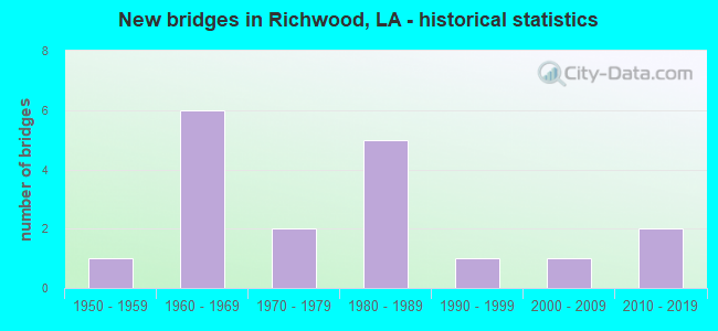
- New bridges - historical statistics
- 11950-1959
- 61960-1969
- 21970-1979
- 51980-1989
- 11990-1999
- 12000-2009
- 22010-2019


- Bridge Condition - Deck
- 12.5%Very good
- 31.3%Good
- 50.0%Satisfactory
- 6.3%Poor

- Bridge Condition - Superstructure
- 12.5%Very good
- 31.3%Good
- 50.0%Satisfactory
- 6.3%Fair

- Bridge Condition - Substructure
- 12.5%Very good
- 31.3%Good
- 50.0%Satisfactory
- 6.3%Poor

- Bridge Condition - Channel
- 6.3%Very good
- 12.5%Good
- 50.0%Satisfactory
- 12.5%Fair
- 12.5%Poor
- 6.3%Failed

- Bridge Condition - Culverts
- 50.0%Satisfactory
- 50.0%Failed
Find on map >> Show street view
Structure Number: 53700000050254, Location: 0.5 MILES WEST OF US 165 (Lat: 32.437550, Lng: -92.097039), Route carried "on" structure: County highway , Year Built: 2015, Status: Open, Structure Length: 1.37m (4.49ft), Average Daily Traffic: 3,111 (year 2008), Average Future Daily Traffic: 1,866 (year 2036), Design Load: H 20, Features Intersected: LTI CREEK, Facility Carried by Structure: RICHWOOD RD #2
Minimum Vertical Clearance: 30+ m (98+ ft), Kilometerpoint: 0.000, Lanes on structure: 2, Owner: County Highway Agency, Approaching Roadway Width: 6.4m (21.0ft), Skew: 30 degrees, Material/Design: Wood or Timber, Design/Construction: Stringer/Multi-beam, Number Of Spans In Main Unit: 3, Length of Maximum Span: 4.6m (15.1ft), Curb-To-Curb Width: 7.0m (23.0ft), Out-to-Out Width: 7.4m (24.3ft)
Condition: Deck: Very good, Superstructure: Very good, Substructure: Good, Channel: Good, Operating Rating: 27.2 metric tons, Method Used To Determine Operating Rating: Allowable Stress (AS), Inventory Rating: 20.0 metric tons, Method Used To Determine Inventory Rating: Allowable Stress (AS), Structural Evaluation: Somewhat better than minimum adequacy, Deck Geometry: High priority of replacement, Waterway Adequacy: Better than present minimum criteria, Approach Roadway Alignment: Equal to present minimum criteria, Designated Inspection Frequency: Every 24 months, Inspection Date: April 2020, Deck Structure Type: Wood or Timber, Wearing Surface/Protective System: Wearing Surface: Bituminous
Find on map >> Show street view
Structure Number: 53700000050261, Location: 0.50 MILES EAST OF LA 15 (Lat: 32.459931, Lng: -92.047919), Route carried "on" structure: County highway , Year Built: 2015, Status: Open, Structure Length: 4.88m (16.01ft), Average Daily Traffic: 700 (year 2001), Average Future Daily Traffic: 420 (year 2036), Design Load: HL 93, Features Intersected: YOUNGS BAYOU, Facility Carried by Structure: MOORE RD
Minimum Vertical Clearance: 30+ m (98+ ft), Kilometerpoint: 0.000, Lanes on structure: 2, Owner: County Highway Agency, Approaching Roadway Width: 5.5m (18.0ft), Skew: 30 degrees, Material/Design: Prestressed concrete, Design/Construction: Stringer/Multi-beam, Number Of Spans In Main Unit: 1, Number Of Approach Spans: 6, Length of Maximum Span: 12.2m (40.0ft), Curb-To-Curb Width: 7.1m (23.3ft), Out-to-Out Width: 8.1m (26.6ft)
Condition: Deck: Very good, Superstructure: Very good, Substructure: Good, Channel: Very good, Operating Rating: 59.3 metric tons, Method Used To Determine Operating Rating: Load and Resistance Factor Rating (LRFR) rating reported by rating factor(RF) method using HL-93 loadings, Inventory Rating: 45.7 metric tons, Method Used To Determine Inventory Rating: Load and Resistance Factor Rating (LRFR) rating reported by rating factor(RF) method using HL-93 loadings, Structural Evaluation: Better than present minimum criteria, Deck Geometry: Meets minimum limits, Waterway Adequacy: Better than present minimum criteria, Approach Roadway Alignment: Equal to present minimum criteria, Designated Inspection Frequency: Every 24 months, Underwater Inspection Frequency: Every 60 months, Inspection Date: March 2020, Underwater Inspection Date: August 2020, Deck Structure Type: Concrete Cast-file-Place, Wearing Surface/Protective System: Wearing Surface: Monolithic Concrete
Find on map >> Show street view
Structure Number: 53700153100281, Location: .28 MI NORTH OF US 165 BU (Lat: 32.415589, Lng: -92.101900), Route carried "on" structure: US 165, Year Built: 1984, Status: Open, Structure Length: 15.27m (50.10ft), Average Daily Traffic: 4,050 (year 2016), Truck Traffic: 9%, Average Future Daily Traffic: 2,412 (year 2036), Design Load: HS 20, Features Intersected: US 165-B & MP RR @ RILLA
Minimum Vertical Clearance: 30+ m (98+ ft), Kilometerpoint: 0.489, Lanes on structure: 2, Lanes under structure: 2, Base Highway Network: Yes (Inventory Route: 15-31-1, Subroute: 10), Owner: State Highway Agency, Approaching Roadway Width: 12.2m (40.0ft), Skew: 10 degrees, Material/Design: Prestressed concrete, Design/Construction: Stringer/Multi-beam, Number Of Spans In Main Unit: 12, Length of Maximum Span: 18.3m (60.0ft), Curb-To-Curb Width: 12.2m (40.0ft), Out-to-Out Width: 13.1m (43.0ft)
Condition: Deck: Good, Superstructure: Good, Substructure: Good, Operating Rating: 66.2 metric tons, Method Used To Determine Operating Rating: Load Factor (LF), Inventory Rating: 39.0 metric tons, Method Used To Determine Inventory Rating: Load Factor (LF), Structural Evaluation: Better than present minimum criteria, Deck Geometry: Better than present minimum criteria, Approach Roadway Alignment: Equal to present minimum criteria, Designated Inspection Frequency: Every 24 months, Inspection Date: September 2020, Deck Structure Type: Other
Find on map >> Show street view
Structure Number: 53700153100282, Location: .28 MI NORTH OF US 165 BU (Lat: 32.417011, Lng: -92.100800), Route carried "on" structure: US 165, Year Built: 1963, Year Reconstructed: 1984, Status: Open, Structure Length: 15.27m (50.10ft), Average Daily Traffic: 4,050 (year 2016), Truck Traffic: 9%, Average Future Daily Traffic: 2,412 (year 2036), Design Load: HS 20, Features Intersected: US 165-B & M P RR @ RILL
Minimum Vertical Clearance: 30+ m (98+ ft), Kilometerpoint: 12.083, Lanes on structure: 2, Lanes under structure: 2, Base Highway Network: Yes (Inventory Route: 15-31-2, Subroute: 10), Owner: State Highway Agency, Approaching Roadway Width: 13.4m (44.0ft), Skew: 14 degrees, Material/Design: Steel, Design/Construction: Stringer/Multi-beam, Number Of Spans In Main Unit: 12, Length of Maximum Span: 18.3m (60.0ft), Curb-To-Curb Width: 12.2m (40.0ft), Out-to-Out Width: 13.1m (43.0ft)
Condition: Deck: Satisfactory, Superstructure: Satisfactory, Substructure: Satisfactory, Operating Rating: 65.3 metric tons, Method Used To Determine Operating Rating: Load Factor (LF), Inventory Rating: 39.0 metric tons, Method Used To Determine Inventory Rating: Load Factor (LF), Structural Evaluation: Equal to present minimum criteria, Deck Geometry: Better than present minimum criteria, Underclear: Better than present minimum criteria, Approach Roadway Alignment: Equal to present minimum criteria, Designated Inspection Frequency: Every 24 months, Inspection Date: September 2020, Deck Structure Type: Concrete Cast-file-Place, Wearing Surface/Protective System: Wearing Surface: Monolithic Concrete
Find on map >> Show street view
Structure Number: 53700153100881, Location: .88 MI NORTH OF US 165 BU (Lat: 32.422750, Lng: -92.095000), Route carried "on" structure: US 165, Year Built: 1963, Year Reconstructed: 1981, Status: Open, Structure Length: 2.44m (8.01ft), Average Daily Traffic: 4,050 (year 2016), Truck Traffic: 9%, Average Future Daily Traffic: 2,412 (year 2036), Design Load: HS 20, Features Intersected: BAYOU MOUCHOIR
Minimum Vertical Clearance: 30+ m (98+ ft), Kilometerpoint: 1.519, Lanes on structure: 2, Base Highway Network: Yes (Inventory Route: 15-31-1, Subroute: 10), Owner: State Highway Agency, Approaching Roadway Width: 13.4m (44.0ft), Skew: 13 degrees, Material/Design: Concrete, Design/Construction: Slab, Number Of Spans In Main Unit: 4, Length of Maximum Span: 6.1m (20.0ft), Curb-To-Curb Width: 12.2m (40.0ft), Out-to-Out Width: 13.0m (42.7ft)
Condition: Deck: Satisfactory, Superstructure: Satisfactory, Substructure: Satisfactory, Channel: Satisfactory, Operating Rating: 62.6 metric tons, Method Used To Determine Operating Rating: Load Factor (LF), Inventory Rating: 37.2 metric tons, Method Used To Determine Inventory Rating: Load Factor (LF), Structural Evaluation: Equal to present minimum criteria, Deck Geometry: Better than present minimum criteria, Waterway Adequacy: Equal to present desirable criteria, Approach Roadway Alignment: Better than present minimum criteria, Designated Inspection Frequency: Every 24 months, Inspection Date: July 2020, Deck Structure Type: Concrete Cast-file-Place, Wearing Surface/Protective System: Wearing Surface: Monolithic Concrete
Find on map >> Show street view
Structure Number: 53700153100882, Location: .88 MI NORTH OF US 165 BU (Lat: 32.422939, Lng: -92.095200), Route carried "on" structure: US 165, Year Built: 1963, Year Reconstructed: 1981, Status: Open, Structure Length: 2.44m (8.01ft), Average Daily Traffic: 4,050 (year 2016), Truck Traffic: 9%, Average Future Daily Traffic: 2,412 (year 2036), Design Load: HS 20, Features Intersected: BAYOU MOUCHOIR
Minimum Vertical Clearance: 30+ m (98+ ft), Kilometerpoint: 11.241, Lanes on structure: 2, Base Highway Network: Yes (Inventory Route: 15-31-2, Subroute: 10), Owner: State Highway Agency, Approaching Roadway Width: 13.4m (44.0ft), Skew: 13 degrees, Material/Design: Concrete, Design/Construction: Slab, Number Of Spans In Main Unit: 4, Length of Maximum Span: 6.1m (20.0ft), Curb-To-Curb Width: 12.2m (40.0ft), Out-to-Out Width: 13.0m (42.7ft)
Condition: Deck: Satisfactory, Superstructure: Satisfactory, Substructure: Satisfactory, Channel: Satisfactory, Operating Rating: 62.6 metric tons, Method Used To Determine Operating Rating: Load Factor (LF), Inventory Rating: 37.2 metric tons, Method Used To Determine Inventory Rating: Load Factor (LF), Structural Evaluation: Equal to present minimum criteria, Deck Geometry: Better than present minimum criteria, Waterway Adequacy: Equal to present desirable criteria, Approach Roadway Alignment: Better than present minimum criteria, Designated Inspection Frequency: Every 24 months, Inspection Date: July 2020, Deck Structure Type: Concrete Cast-file-Place, Wearing Surface/Protective System: Wearing Surface: Monolithic Concrete
Find on map >> Show street view
Structure Number: 53700153101061, Location: 1.06 MI NORTH OF US 165 B (Lat: 32.424950, Lng: -92.093800), Route carried "on" structure: US 165, Year Built: 1963, Year Reconstructed: 1981, Status: Open, Structure Length: 2.44m (8.01ft), Average Daily Traffic: 4,050 (year 2016), Truck Traffic: 9%, Average Future Daily Traffic: 2,412 (year 2036), Design Load: HS 20, Features Intersected: BAYOU MOUCHOIR
Minimum Vertical Clearance: 30+ m (98+ ft), Kilometerpoint: 1.783, Lanes on structure: 2, Base Highway Network: Yes (Inventory Route: 15-31-1, Subroute: 10), Owner: State Highway Agency, Approaching Roadway Width: 13.4m (44.0ft), Skew: 10 degrees, Material/Design: Concrete, Design/Construction: Slab, Number Of Spans In Main Unit: 4, Length of Maximum Span: 6.1m (20.0ft), Curb-To-Curb Width: 12.2m (40.0ft), Out-to-Out Width: 13.0m (42.7ft)
Condition: Deck: Satisfactory, Superstructure: Satisfactory, Substructure: Satisfactory, Channel: Satisfactory, Operating Rating: 62.6 metric tons, Method Used To Determine Operating Rating: Load Factor (LF), Inventory Rating: 37.2 metric tons, Method Used To Determine Inventory Rating: Load Factor (LF), Structural Evaluation: Equal to present minimum criteria, Deck Geometry: Better than present minimum criteria, Waterway Adequacy: Equal to present desirable criteria, Approach Roadway Alignment: Equal to present desirable criteria, Designated Inspection Frequency: Every 24 months, Inspection Date: July 2020, Deck Structure Type: Concrete Cast-file-Place, Wearing Surface/Protective System: Wearing Surface: Monolithic Concrete
Find on map >> Show street view
Structure Number: 53700153101062, Location: 1.06 MI NORTH OF US 165 B (Lat: 32.425369, Lng: -92.093900), Route carried "on" structure: US 165, Year Built: 1963, Year Reconstructed: 1981, Status: Open, Structure Length: 2.44m (8.01ft), Average Daily Traffic: 4,050 (year 2016), Truck Traffic: 9%, Average Future Daily Traffic: 2,412 (year 2036), Design Load: HS 20, Features Intersected: BAYOU MOUCHOIR
Minimum Vertical Clearance: 30+ m (98+ ft), Kilometerpoint: 11.241, Lanes on structure: 2, Base Highway Network: Yes (Inventory Route: 15-31-2, Subroute: 10), Owner: State Highway Agency, Approaching Roadway Width: 13.4m (44.0ft), Skew: 13 degrees, Material/Design: Concrete, Design/Construction: Slab, Number Of Spans In Main Unit: 4, Length of Maximum Span: 6.1m (20.0ft), Curb-To-Curb Width: 12.2m (40.0ft), Out-to-Out Width: 13.0m (42.7ft)
Condition: Deck: Satisfactory, Superstructure: Satisfactory, Substructure: Satisfactory, Channel: Satisfactory, Operating Rating: 62.6 metric tons, Method Used To Determine Operating Rating: Load Factor (LF), Inventory Rating: 37.2 metric tons, Method Used To Determine Inventory Rating: Load Factor (LF), Structural Evaluation: Equal to present minimum criteria, Deck Geometry: Better than present minimum criteria, Waterway Adequacy: Better than present minimum criteria, Approach Roadway Alignment: Better than present minimum criteria, Designated Inspection Frequency: Every 24 months, Inspection Date: July 2020, Deck Structure Type: Concrete Cast-file-Place, Wearing Surface/Protective System: Wearing Surface: Monolithic Concrete
Find on map >> Show street view
Structure Number: 53700261001681, Location: 3.8 MI EAST OF LA 841 (Lat: 32.407789, Lng: -92.018700), Route carried "on" structure: State highway 15, Year Built: 1954, Status: Open, Structure Length: 2.44m (8.01ft), Average Daily Traffic: 2,700 (year 2016), Truck Traffic: 16%, Average Future Daily Traffic: 1,500 (year 2036), Design Load: HS 20, Features Intersected: BLACK STEEP BAYOU
Minimum Vertical Clearance: 30+ m (98+ ft), Kilometerpoint: 2.680, Lanes on structure: 2, Base Highway Network: Yes (Inventory Route: 26-10-1, Subroute: 10), Owner: State Highway Agency, Approaching Roadway Width: 9.8m (32.2ft), Material/Design: Concrete, Design/Construction: Slab, Number Of Spans In Main Unit: 4, Length of Maximum Span: 6.1m (20.0ft), Curb-To-Curb Width: 7.9m (25.9ft), Out-to-Out Width: 9.5m (31.2ft)
Condition: Deck: Satisfactory, Superstructure: Satisfactory, Substructure: Satisfactory, Channel: Satisfactory, Operating Rating: 33.6 metric tons, Method Used To Determine Operating Rating: Load Factor (LF), Inventory Rating: 20.0 metric tons, Method Used To Determine Inventory Rating: Load Factor (LF), Structural Evaluation: Somewhat better than minimum adequacy, Deck Geometry: High priority of corrective action, Waterway Adequacy: Equal to present minimum criteria, Approach Roadway Alignment: Equal to present minimum criteria, Length Of Structure Improvement: 3.23m (10.60ft), Designated Inspection Frequency: Every 24 months, Inspection Date: August 2020, Bridge Improvement Cost: $275,000, Total Project Cost: $412,000 ( Estimate for 2016), Deck Structure Type: Concrete Cast-file-Place, Wearing Surface/Protective System: Wearing Surface: Bituminous
Find on map >> Show street view
Structure Number: 53708370807131, Location: LA 841 (Lat: 32.420911, Lng: -92.051800), Route carried "on" structure: State highway 841, Year Built: 1979, Status: Open, Structure Length: 1.22m (4.00ft), Average Daily Traffic: 2,900 (year 2016), Truck Traffic: 15%, Average Future Daily Traffic: 1,860 (year 2036), Design Load: HS 20, Features Intersected: BAYOU
Minimum Vertical Clearance: 30+ m (98+ ft), Kilometerpoint: 11.562, Lanes on structure: 2, Owner: State Highway Agency, Approaching Roadway Width: 8.5m (27.9ft), Material/Design: Steel, Design/Construction: Culvert, Number Of Spans In Main Unit: 3, Length of Maximum Span: 3.0m (9.8ft), Curb-To-Curb Width: 7.0m (23.0ft), Out-to-Out Width: 19.5m (64.0ft)
Condition: Channel: Poor, Culverts: Satisfactory, Operating Rating: 97.2 metric tons, Method Used To Determine Operating Rating: Load and Resistance Factor Rating (LRFR) rating reported by rating factor(RF) method using HL-93 loadings, Inventory Rating: 74.5 metric tons, Method Used To Determine Inventory Rating: Load and Resistance Factor Rating (LRFR) rating reported by rating factor(RF) method using HL-93 loadings, Structural Evaluation: Equal to present minimum criteria, Deck Geometry: High priority of replacement, Waterway Adequacy: Better than present minimum criteria, Approach Roadway Alignment: Better than present minimum criteria, Length Of Structure Improvement: 1.89m (6.20ft), Designated Inspection Frequency: Every 24 months, Inspection Date: October 2020, Bridge Improvement Cost: $161,000, Total Project Cost: $241,000 ( Estimate for 2016)
Find on map >> Show street view
Structure Number: 53732222920451, Location: 2.51 MI NE of US 165 S (Lat: 32.380761, Lng: -92.076661), Route carried "on" structure: County highway , Year Built: 2005, Status: Open, Structure Length: 3.05m (10.01ft), Average Daily Traffic: 3,000 (year 2003), Average Future Daily Traffic: 1,800 (year 2036), Design Load: HS 20, Features Intersected: PRAIRIE BAYOU, Facility Carried by Structure: ANGUS RD
Minimum Vertical Clearance: 30+ m (98+ ft), Kilometerpoint: 0.000, Lanes on structure: 2, Base Highway Network: Yes, Owner: County Highway Agency, Approaching Roadway Width: 7.3m (24.0ft), Material/Design: Concrete, Design/Construction: Slab, Number Of Spans In Main Unit: 5, Length of Maximum Span: 6.1m (20.0ft), Curb-To-Curb Width: 7.3m (24.0ft), Out-to-Out Width: 8.1m (26.6ft)
Condition: Deck: Good, Superstructure: Good, Substructure: Very good, Channel: Good, Operating Rating: 50.2 metric tons, Method Used To Determine Operating Rating: Load and Resistance Factor Rating (LRFR) rating reported by rating factor(RF) method using HL-93 loadings, Inventory Rating: 35.0 metric tons, Method Used To Determine Inventory Rating: Load and Resistance Factor Rating (LRFR) rating reported by rating factor(RF) method using HL-93 loadings, Structural Evaluation: Better than present minimum criteria, Deck Geometry: High priority of replacement, Waterway Adequacy: Better than present minimum criteria, Approach Roadway Alignment: Better than present minimum criteria, Length Of Structure Improvement: 3.90m (12.80ft), Designated Inspection Frequency: Every 24 months, Inspection Date: March 2020, Bridge Improvement Cost: $232,000, Total Project Cost: $348,000 ( Estimate for 2016), Deck Structure Type: Concrete Cast-file-Place
Find on map >> Show street view
Structure Number: 53732230920791, Location: 4.24 MI E of LA 557 (Lat: 32.382361, Lng: -92.130639), Route carried "on" structure: County highway , Year Built: 1993, Status: Posted for load, Structure Length: 6.31m (20.70ft), Average Daily Traffic: 715 (year 1979), Average Future Daily Traffic: 429 (year 2036), Design Load: HS 20, Features Intersected: LAPINE CREEK, Facility Carried by Structure: PHILPET RD
Minimum Vertical Clearance: 30+ m (98+ ft), Kilometerpoint: 0.000, Lanes on structure: 2, Owner: County Highway Agency, Approaching Roadway Width: 7.9m (25.9ft), Material/Design: Concrete, Design/Construction: Slab, Number Of Spans In Main Unit: 11, Length of Maximum Span: 5.8m (19.0ft), Curb-To-Curb Width: 7.3m (24.0ft), Out-to-Out Width: 8.2m (26.9ft)
Condition: Deck: Good, Superstructure: Good, Substructure: Very good, Channel: Fair, Operating Rating: 40.8 metric tons, Method Used To Determine Operating Rating: Load and Resistance Factor Rating (LRFR) rating reported by rating factor(RF) method using HL-93 loadings, Inventory Rating: 31.4 metric tons, Method Used To Determine Inventory Rating: Load and Resistance Factor Rating (LRFR) rating reported by rating factor(RF) method using HL-93 loadings, Structural Evaluation: Better than present minimum criteria, Deck Geometry: Meets minimum limits, Waterway Adequacy: Equal to present desirable criteria, Approach Roadway Alignment: Equal to present minimum criteria, Designated Inspection Frequency: Every 24 months, Underwater Inspection Frequency: Every 60 months, Inspection Date: June 2020, Underwater Inspection Date: November 2020, Deck Structure Type: Concrete Cast-file-Place
Find on map >> Show street view
Structure Number: 53732232920231, Location: LOG MILE 0.35 RT. 318 (Lat: 32.387531, Lng: -92.040131), Route carried "on" structure: County highway , Year Built: 1981, Status: Open, Structure Length: 2.90m (9.51ft), Average Daily Traffic: 330 (year 1980), Average Future Daily Traffic: 198 (year 2036), Design Load: HS 20, Features Intersected: PETTICOAT BAYOU, Facility Carried by Structure: MILLER RD
Minimum Vertical Clearance: 30+ m (98+ ft), Kilometerpoint: 0.000, Lanes on structure: 2, Owner: County Highway Agency, Approaching Roadway Width: 6.4m (21.0ft), Material/Design: Concrete, Design/Construction: Slab, Number Of Spans In Main Unit: 5, Length of Maximum Span: 5.8m (19.0ft), Curb-To-Curb Width: 7.3m (24.0ft), Out-to-Out Width: 8.4m (27.6ft)
Condition: Deck: Satisfactory, Superstructure: Satisfactory, Substructure: Satisfactory, Channel: Satisfactory, Operating Rating: 34.7 metric tons, Method Used To Determine Operating Rating: Load and Resistance Factor Rating (LRFR) rating reported by rating factor(RF) method using HL-93 loadings, Inventory Rating: 26.6 metric tons, Method Used To Determine Inventory Rating: Load and Resistance Factor Rating (LRFR) rating reported by rating factor(RF) method using HL-93 loadings, Structural Evaluation: Equal to present minimum criteria, Deck Geometry: Somewhat better than minimum adequacy, Waterway Adequacy: Better than present minimum criteria, Approach Roadway Alignment: Equal to present desirable criteria, Designated Inspection Frequency: Every 24 months, Inspection Date: March 2020, Deck Structure Type: Concrete Precast Panels, Wearing Surface/Protective System: Wearing Surface: Bituminous
Find on map >> Show street view
Structure Number: 53732237920471, Location: 2.2 MI. E. U.S. HWY. (Lat: 32.397411, Lng: -92.073350), Route carried "on" structure: County highway , Year Built: 1968, Status: Temporarily open, Structure Length: 0.61m (2.00ft), Average Daily Traffic: 570 (year 1977), Average Future Daily Traffic: 342 (year 2036), Design Load: HS 20, Features Intersected: DRAIN TO PRAIRIE BAYOU, Facility Carried by Structure: HARMON JOHNSON RD
Minimum Vertical Clearance: 30+ m (98+ ft), Kilometerpoint: 0.000, Lanes on structure: 2, Owner: County Highway Agency, Approaching Roadway Width: 6.1m (20.0ft), Material/Design: Steel, Design/Construction: Culvert, Number Of Spans In Main Unit: 2, Length of Maximum Span: 3.0m (9.8ft), Curb-To-Curb Width: 6.1m (20.0ft), Out-to-Out Width: 16.5m (54.1ft)
Condition: Channel: Failed, Culverts: Failed, Deck Geometry: High priority of corrective action, Waterway Adequacy: Better than present minimum criteria, Approach Roadway Alignment: Equal to present desirable criteria, Bridge Posting: Required (Relationship of Operating Rating to Maximum Legal Load: > 39.9% below), Length Of Structure Improvement: 1.22m (4.00ft), Designated Inspection Frequency: Every 24 months, Other Special Inspection Frequency: Every 6 months, Inspection Date: March 2020, Other Special Inspection Date: September 2021, Bridge Improvement Cost: $72,000, Total Project Cost: $108,000 ( Estimate for 2016)
Find on map >> Show street view
Structure Number: 53732245920261, Location: 3 MI S PINE GROVE (Lat: 32.408361, Lng: -92.043781), Route carried "on" structure: County highway , Year Built: 1978, Status: Posted for load, Structure Length: 2.71m (8.89ft), Average Daily Traffic: 300 (year 1980), Average Future Daily Traffic: 180 (year 2036), Design Load: H 20, Features Intersected: PETTICOAT BAYOU, Facility Carried by Structure: CRAWFORD RD
Minimum Vertical Clearance: 30+ m (98+ ft), Kilometerpoint: 0.000, Lanes on structure: 1, Owner: County Highway Agency, Approaching Roadway Width: 7.9m (25.9ft), Material/Design: Wood or Timber, Design/Construction: Stringer/Multi-beam, Number Of Spans In Main Unit: 6, Length of Maximum Span: 4.6m (15.1ft), Curb-To-Curb Width: 5.9m (19.4ft), Out-to-Out Width: 6.2m (20.3ft)
Condition: Deck: Poor, Superstructure: Fair, Substructure: Poor, Channel: Satisfactory, Operating Rating: 29.0 metric tons, Method Used To Determine Operating Rating: Allowable Stress (AS), Inventory Rating: 20.0 metric tons, Method Used To Determine Inventory Rating: Allowable Stress (AS), Structural Evaluation: Meets minimum limits, Deck Geometry: High priority of corrective action, Waterway Adequacy: Equal to present minimum criteria, Approach Roadway Alignment: Equal to present desirable criteria, Length Of Structure Improvement: 3.51m (11.52ft), Designated Inspection Frequency: Every 24 months, Other Special Inspection Frequency: Every 12 months, Inspection Date: March 2020, Other Special Inspection Date: March 2021, Bridge Improvement Cost: $209,000, Total Project Cost: $313,000 ( Estimate for 2016), Deck Structure Type: Wood or Timber, Wearing Surface/Protective System: Wearing Surface: Bituminous
Find on map >> Show street view
Structure Number: 53732268920151, Location: 2.5 MI S.MONROE (Lat: 32.447900, Lng: -92.025950), Route carried "on" structure: County highway , Year Built: 1984, Status: Open, Structure Length: 4.05m (13.29ft), Average Daily Traffic: 278 (year 1979), Average Future Daily Traffic: 166 (year 2036), Design Load: HS 20, Features Intersected: YOUNGS BAYOU, Facility Carried by Structure: GOURD BAYOU RD
Minimum Vertical Clearance: 30+ m (98+ ft), Kilometerpoint: 0.000, Lanes on structure: 2, Owner: County Highway Agency, Approaching Roadway Width: 7.0m (23.0ft), Material/Design: Concrete, Design/Construction: Slab, Number Of Spans In Main Unit: 7, Length of Maximum Span: 5.8m (19.0ft), Curb-To-Curb Width: 8.5m (27.9ft), Out-to-Out Width: 9.4m (30.8ft)
Condition: Deck: Satisfactory, Superstructure: Satisfactory, Substructure: Good, Channel: Poor, Operating Rating: 53.1 metric tons, Method Used To Determine Operating Rating: Load and Resistance Factor Rating (LRFR) rating reported by rating factor(RF) method using HL-93 loadings, Inventory Rating: 40.8 metric tons, Method Used To Determine Inventory Rating: Load and Resistance Factor Rating (LRFR) rating reported by rating factor(RF) method using HL-93 loadings, Structural Evaluation: Equal to present minimum criteria, Deck Geometry: Equal to present minimum criteria, Waterway Adequacy: Better than present minimum criteria, Approach Roadway Alignment: Better than present minimum criteria, Designated Inspection Frequency: Every 24 months, Underwater Inspection Frequency: Every 60 months, Inspection Date: March 2020, Underwater Inspection Date: November 2020, Deck Structure Type: Concrete Precast Panels, Wearing Surface/Protective System: Wearing Surface: Bituminous
Find on map >> Show street view
Structure Number: 53732280920341, Location: GARRET ROAD (Lat: 32.467150, Lng: -92.058281), Route carried "on" structure: County highway , Year Built: 1982, Status: Open, Structure Length: 4.66m (15.29ft), Average Daily Traffic: 600 (year 1980), Average Future Daily Traffic: 360 (year 2036), Design Load: HS 20, Features Intersected: YOUNGS BAYOU, Facility Carried by Structure: GARRETT RD
Minimum Vertical Clearance: 30+ m (98+ ft), Kilometerpoint: 0.000, Lanes on structure: 2, Owner: County Highway Agency, Approaching Roadway Width: 8.5m (27.9ft), Material/Design: Concrete, Design/Construction: Slab, Number Of Spans In Main Unit: 8, Length of Maximum Span: 5.8m (19.0ft), Curb-To-Curb Width: 9.8m (32.2ft), Out-to-Out Width: 10.6m (34.8ft)
Condition: Deck: Good, Superstructure: Good, Substructure: Good, Channel: Satisfactory, Operating Rating: 43.1 metric tons, Method Used To Determine Operating Rating: Load and Resistance Factor Rating (LRFR) rating reported by rating factor(RF) method using HL-93 loadings, Inventory Rating: 33.4 metric tons, Method Used To Determine Inventory Rating: Load and Resistance Factor Rating (LRFR) rating reported by rating factor(RF) method using HL-93 loadings, Structural Evaluation: Better than present minimum criteria, Deck Geometry: Equal to present minimum criteria, Waterway Adequacy: Better than present minimum criteria, Approach Roadway Alignment: Equal to present desirable criteria, Designated Inspection Frequency: Every 24 months, Inspection Date: March 2020, Deck Structure Type: Concrete Precast Panels
Find on map >> Show street view
Structure Number: 53732283920411, Location: 2 MILES S OF MONROE (Lat: 32.472600, Lng: -92.069061), Route carried "on" structure: County highway , Year Built: 1982, Status: Open, Structure Length: 4.66m (15.29ft), Average Daily Traffic: 400 (year 1980), Average Future Daily Traffic: 240 (year 2036), Design Load: HS 20, Features Intersected: YOUNGS BAYOU, Facility Carried by Structure: NUTLAND RD
Minimum Vertical Clearance: 30+ m (98+ ft), Kilometerpoint: 0.000, Lanes on structure: 2, Owner: County Highway Agency, Approaching Roadway Width: 8.5m (27.9ft), Material/Design: Concrete, Design/Construction: Slab, Number Of Spans In Main Unit: 8, Length of Maximum Span: 5.8m (19.0ft), Curb-To-Curb Width: 8.5m (27.9ft), Out-to-Out Width: 9.4m (30.8ft)
Condition: Deck: Good, Superstructure: Good, Substructure: Satisfactory, Channel: Fair, Operating Rating: 42.4 metric tons, Method Used To Determine Operating Rating: Load and Resistance Factor Rating (LRFR) rating reported by rating factor(RF) method using HL-93 loadings, Inventory Rating: 32.7 metric tons, Method Used To Determine Inventory Rating: Load and Resistance Factor Rating (LRFR) rating reported by rating factor(RF) method using HL-93 loadings, Structural Evaluation: Equal to present minimum criteria, Deck Geometry: Equal to present minimum criteria, Waterway Adequacy: Better than present minimum criteria, Approach Roadway Alignment: Equal to present minimum criteria, Designated Inspection Frequency: Every 24 months, Underwater Inspection Frequency: Every 60 months, Inspection Date: March 2020, Underwater Inspection Date: November 2020, Deck Structure Type: Concrete Precast Panels
Find on map >> Show street view
Structure Number: 53700153100282, Location: 10 MI N OF CALDWELL PL (Lat: 32.416481, Lng: -92.101500), Route carried "under" structure: US 165, Structure Length: 0. m, Average Daily Traffic: 4,020 (year 2015), Features Intersected: 165 SB OVER 165 BRANCH @
Minimum Vertical Clearance: 7.53m (24.70ft), Kilometerpoint: 16.636, Lanes on structure: 2, Length of Maximum Span: 0.0m
Find on map >> Show street view
Structure Number: 53700153100282, Location: 10 MI N OF CALDWELL PL (Lat: 32.415931, Lng: -92.101461), Route carried "under" structure: US 165, Structure Length: 0. m, Average Daily Traffic: 4,020 (year 2015), Features Intersected: 165 NB OVER 165 BRANCH @
Minimum Vertical Clearance: 7.41m (24.31ft), Kilometerpoint: 16.636, Lanes on structure: 2, Length of Maximum Span: 0.0m