Bridge Statistics for Richview, Illinois (IL)
Condition, Traffic, Stress, Structural Evaluation, Project Costs
- National Bridge Inventory (NBI) Statistics
- 19Number of bridges
- 177ft / 53.8mTotal length
- 150,300Total average daily traffic
- 44,847Total average daily truck traffic
- National Bridge Inventory (NBI) Registered Bridges for Richview
- No street view available for this location
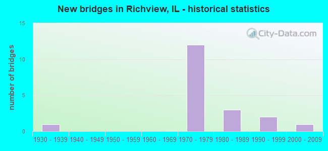
- New bridges - historical statistics
- 11930-1939
- 121970-1979
- 31980-1989
- 21990-1999
- 12000-2009

- Reconstructed bridges - Historical Statistics
- 11960-1969
- 01970-1979
- 41980-1989


- Bridge Condition - Deck
- 28.6%Very good
- 21.4%Good
- 35.7%Satisfactory
- 14.3%Fair

- Bridge Condition - Superstructure
- 28.6%Very good
- 28.6%Good
- 35.7%Satisfactory
- 7.1%Poor

- Bridge Condition - Substructure
- 35.7%Very good
- 42.9%Good
- 14.3%Satisfactory
- 7.1%Critical

- Bridge Condition - Channel
- 11.1%Very good
- 44.4%Good
- 33.3%Satisfactory
- 11.1%Poor
Find on map >> Show street view
Structure Number: 410064, Location: 1 MI E WASH CO LN (Lat: 38.385311, Lng: -89.126969), Route carried "on" structure: County highway , Year Built: 1972, Status: Open, Structure Length: 7.44m (24.41ft), Average Daily Traffic: 75 (year 2021), Truck Traffic: 28%, Average Future Daily Traffic: 111 (year 2032), Design Load: HS 15, Features Intersected: FAI-64, Facility Carried by Structure: TR-26
Minimum Vertical Clearance: 30+ m (98+ ft), Kilometerpoint: 3.396, Lanes on structure: 2, Lanes under structure: 4, Owner: State Highway Agency, Approaching Roadway Width: 6.7m (22.0ft), Material/Design: Steel continuous, Design/Construction: Stringer/Multi-beam, Number Of Spans In Main Unit: 2, Number Of Approach Spans: 2, Length of Maximum Span: 28.3m (92.8ft), Curb-To-Curb Width: 8.1m (26.6ft), Out-to-Out Width: 9.2m (30.2ft)
Condition: Deck: Good, Superstructure: Satisfactory, Substructure: Good, Operating Rating: 48.0 metric tons, Method Used To Determine Operating Rating: Load Factor (LF) rating reported by rating factor (RF) method using MS18 loading, Inventory Rating: 28.8 metric tons, Method Used To Determine Inventory Rating: Load Factor (LF) rating reported by rating factor (RF) method using MS18 loading, Structural Evaluation: Equal to present minimum criteria, Deck Geometry: Equal to present minimum criteria, Underclear: Somewhat better than minimum adequacy, Approach Roadway Alignment: Equal to present desirable criteria, Designated Inspection Frequency: Every 24 months, Other Special Inspection Frequency: Every 48 months, Inspection Date: April 2020, Other Special Inspection Date: Febuary 2020, Deck Structure Type: Concrete Cast-file-Place
Find on map >> Show street view
Structure Number: 410085, Location: 4.5 MI W WOODLAWN IN (Lat: 38.380386, Lng: -89.113350), Route carried "on" structure: Interstate 64, Year Built: 1974, Status: Open, Structure Length: 4.05m (13.29ft), Average Daily Traffic: 14,650 (year 2021), Truck Traffic: 32%, Average Future Daily Traffic: 12,100 (year 2032), Design Load: HS 20+Mod, Features Intersected: RAYSE CK
Minimum Vertical Clearance: 30+ m (98+ ft), Kilometerpoint: 103.269, Lanes on structure: 2, Base Highway Network: Yes, Owner: State Highway Agency, Approaching Roadway Width: 12.2m (40.0ft), Material/Design: Prestressed concrete, Design/Construction: Stringer/Multi-beam, Number Of Spans In Main Unit: 2, Length of Maximum Span: 20.1m (65.9ft), Curb-To-Curb Width: 11.7m (38.4ft), Out-to-Out Width: 12.8m (42.0ft)
Condition: Deck: Fair, Superstructure: Satisfactory, Substructure: Satisfactory, Channel: Good, Operating Rating: 64.8 metric tons, Method Used To Determine Operating Rating: Load Factor (LF) rating reported by rating factor (RF) method using MS18 loading, Inventory Rating: 40.2 metric tons, Method Used To Determine Inventory Rating: Load Factor (LF) rating reported by rating factor (RF) method using MS18 loading, Structural Evaluation: Equal to present minimum criteria, Deck Geometry: Equal to present minimum criteria, Waterway Adequacy: Equal to present desirable criteria, Approach Roadway Alignment: Equal to present desirable criteria, Designated Inspection Frequency: Every 24 months, Inspection Date: July 2021, Deck Structure Type: Concrete Cast-file-Place, Wearing Surface/Protective System: Wearing Surface: Other
Find on map >> Show street view
Structure Number: 410086, Location: 4.5 MI W WOODLAN INT (Lat: 38.380453, Lng: -89.113519), Route carried "on" structure: Interstate 64, Year Built: 1974, Status: Open, Structure Length: 4.05m (13.29ft), Average Daily Traffic: 14,650 (year 2021), Truck Traffic: 32%, Average Future Daily Traffic: 12,100 (year 2032), Design Load: HS 20+Mod, Features Intersected: RAYSE CREEK
Minimum Vertical Clearance: 30+ m (98+ ft), Kilometerpoint: 103.253, Lanes on structure: 2, Base Highway Network: Yes, Owner: State Highway Agency, Approaching Roadway Width: 12.2m (40.0ft), Material/Design: Prestressed concrete, Design/Construction: Stringer/Multi-beam, Number Of Spans In Main Unit: 2, Length of Maximum Span: 20.1m (65.9ft), Curb-To-Curb Width: 11.7m (38.4ft), Out-to-Out Width: 12.8m (42.0ft)
Condition: Deck: Satisfactory, Superstructure: Satisfactory, Substructure: Satisfactory, Channel: Good, Operating Rating: 64.8 metric tons, Method Used To Determine Operating Rating: Load Factor (LF) rating reported by rating factor (RF) method using MS18 loading, Inventory Rating: 40.2 metric tons, Method Used To Determine Inventory Rating: Load Factor (LF) rating reported by rating factor (RF) method using MS18 loading, Structural Evaluation: Equal to present minimum criteria, Deck Geometry: Equal to present minimum criteria, Waterway Adequacy: Equal to present desirable criteria, Approach Roadway Alignment: Equal to present desirable criteria, Designated Inspection Frequency: Every 24 months, Inspection Date: July 2021, Deck Structure Type: Concrete Cast-file-Place, Wearing Surface/Protective System: Wearing Surface: Other
Find on map >> Show street view
Structure Number: 413635, Location: 2.5 MI SW CRAVAT (Lat: 38.394250, Lng: -89.118786), Route carried "on" structure: County highway , Year Built: 1984, Status: Open, Structure Length: 1.89m (6.20ft), Average Daily Traffic: 25 (year 2021), Truck Traffic: 16%, Average Future Daily Traffic: 28 (year 2032), Design Load: HS 20, Features Intersected: RAYSE CREEK, Facility Carried by Structure: TR-133
Minimum Vertical Clearance: 30+ m (98+ ft), Kilometerpoint: 2.559, Lanes on structure: 2, Owner: Town or Township Highway Agency, Approaching Roadway Width: 6.1m (20.0ft), Material/Design: Prestressed concrete, Design/Construction: Box Beam or Girders - Multiple, Number Of Spans In Main Unit: 1, Length of Maximum Span: 17.7m (58.1ft), Curb-To-Curb Width: 7.4m (24.3ft), Out-to-Out Width: 7.4m (24.3ft)
Condition: Deck: Very good, Superstructure: Very good, Substructure: Good, Channel: Good, Operating Rating: 44.4 metric tons, Method Used To Determine Operating Rating: Assigned rating based on Load Factor Design (LFD) reported by rating factor (RF) using MS18 loading, Inventory Rating: 32.4 metric tons, Method Used To Determine Inventory Rating: Assigned rating based on Load Factor Design (LFD) reported by rating factor (RF) using MS18 loading, Structural Evaluation: Better than present minimum criteria, Deck Geometry: Equal to present minimum criteria, Waterway Adequacy: Better than present minimum criteria, Approach Roadway Alignment: Equal to present desirable criteria, Designated Inspection Frequency: Every 48 months, Inspection Date: January 2022, Deck Structure Type: Concrete Precast Panels
Find on map >> Show street view
Structure Number: 41364, Location: 5 MI NW WOODLAWN (Lat: 38.352456, Lng: -89.127211), Route carried "on" structure: County highway , Year Built: 1997, Status: Open, Structure Length: 4.92m (16.14ft), Average Daily Traffic: 100 (year 2021), Truck Traffic: 24%, Average Future Daily Traffic: 138 (year 2032), Design Load: HS 20, Features Intersected: RAYSE CREEK, Facility Carried by Structure: CH-14
Minimum Vertical Clearance: 30+ m (98+ ft), Kilometerpoint: 4.683, Lanes on structure: 2, Owner: County Highway Agency, Approaching Roadway Width: 6.1m (20.0ft), Material/Design: Prestressed concrete, Design/Construction: Box Beam or Girders - Multiple, Number Of Spans In Main Unit: 3, Length of Maximum Span: 18.3m (60.0ft), Curb-To-Curb Width: 8.5m (27.9ft), Out-to-Out Width: 8.5m (27.9ft)
Condition: Deck: Satisfactory, Superstructure: Satisfactory, Substructure: Good, Channel: Good, Operating Rating: 44.1 metric tons, Method Used To Determine Operating Rating: Assigned rating based on Load Factor Design (LFD) reported by rating factor (RF) using MS18 loading, Inventory Rating: 32.4 metric tons, Method Used To Determine Inventory Rating: Assigned rating based on Load Factor Design (LFD) reported by rating factor (RF) using MS18 loading, Structural Evaluation: Equal to present minimum criteria, Deck Geometry: Better than present minimum criteria, Waterway Adequacy: Better than present minimum criteria, Approach Roadway Alignment: Equal to present desirable criteria, Designated Inspection Frequency: Every 24 months, Inspection Date: January 2022, Deck Structure Type: Concrete Precast Panels, Wearing Surface/Protective System: Wearing Surface: Gravel
Find on map >> Show street view
Structure Number: 413742, Location: 5 MI WNW WOODLAWN (Lat: 38.353694, Lng: -89.140914), Route carried "on" structure: County highway , Year Built: 2009, Status: Open, Structure Length: 4.07m (13.35ft), Average Daily Traffic: 25 (year 2021), Truck Traffic: 12%, Average Future Daily Traffic: 28 (year 2032), Design Load: HS 25 or greater, Features Intersected: RAYSE CREEK, Facility Carried by Structure: N DOPPLER LANE
Minimum Vertical Clearance: 30+ m (98+ ft), Kilometerpoint: 3.315, Lanes on structure: 2, Owner: Town or Township Highway Agency, Approaching Roadway Width: 4.9m (16.1ft), Material/Design: Prestressed concrete, Design/Construction: Box Beam or Girders - Multiple, Number Of Spans In Main Unit: 3, Length of Maximum Span: 13.4m (44.0ft), Curb-To-Curb Width: 7.3m (24.0ft), Out-to-Out Width: 7.3m (24.0ft)
Condition: Deck: Very good, Superstructure: Very good, Substructure: Very good, Channel: Very good, Operating Rating: 44.1 metric tons, Method Used To Determine Operating Rating: Assigned rating based on Load Factor Design (LFD) reported by rating factor (RF) using MS18 loading, Inventory Rating: 32.4 metric tons, Method Used To Determine Inventory Rating: Assigned rating based on Load Factor Design (LFD) reported by rating factor (RF) using MS18 loading, Structural Evaluation: Equal to present desirable criteria, Deck Geometry: Equal to present minimum criteria, Waterway Adequacy: Equal to present desirable criteria, Approach Roadway Alignment: Equal to present desirable criteria, Designated Inspection Frequency: Every 48 months, Inspection Date: Febuary 2020, Deck Structure Type: Concrete Precast Panels
Find on map >> Show street view
Structure Number: 415009, Location: 2.5 MI SW CRAVAT (Lat: 38.383783, Lng: -89.112006), Route carried "on" structure: County highway , Year Built: 1981, Status: Open, Structure Length: 0.82m (2.69ft), Average Daily Traffic: 50 (year 2021), Truck Traffic: 16%, Average Future Daily Traffic: 83 (year 2032), Features Intersected: RAYSE CREEK, Facility Carried by Structure: TR-143
Minimum Vertical Clearance: 30+ m (98+ ft), Kilometerpoint: 1.448, Lanes on structure: 2, Owner: Town or Township Highway Agency, Approaching Roadway Width: 6.1m (20.0ft), Material/Design: Concrete, Design/Construction: Culvert, Number Of Spans In Main Unit: 2, Length of Maximum Span: 3.9m (12.8ft)
Condition: Channel: Satisfactory, Culverts: Good, Operating Rating: 40.5 metric tons, Method Used To Determine Operating Rating: Field evaluation and documented engineering judgment, Inventory Rating: 24.3 metric tons, Method Used To Determine Inventory Rating: Field evaluation and documented engineering judgment, Structural Evaluation: Equal to present minimum criteria, Waterway Adequacy: Equal to present desirable criteria, Approach Roadway Alignment: Equal to present desirable criteria, Designated Inspection Frequency: Every 24 months, Inspection Date: May 2021
Find on map >> Show street view
Structure Number: 95006, Location: 0.98 MI N RICHVIEW (Lat: 38.388108, Lng: -89.191536), Route carried "on" structure: County highway , Year Built: 1972, Status: Open, Structure Length: 5.49m (18.01ft), Average Daily Traffic: 175 (year 2019), Truck Traffic: 22%, Average Future Daily Traffic: 134 (year 2032), Design Load: HS 15, Features Intersected: FAI 64, Facility Carried by Structure: TOWER RD - TR 236
Minimum Vertical Clearance: 30+ m (98+ ft), Kilometerpoint: 5.600, Lanes on structure: 2, Lanes under structure: 4, Owner: State Highway Agency, Approaching Roadway Width: 8.5m (27.9ft), Material/Design: Steel continuous, Design/Construction: Stringer/Multi-beam, Number Of Spans In Main Unit: 2, Number Of Approach Spans: 2, Length of Maximum Span: 27.4m (89.9ft), Curb-To-Curb Width: 8.1m (26.6ft), Out-to-Out Width: 9.1m (29.9ft)
Condition: Deck: Very good, Superstructure: Very good, Substructure: Very good, Operating Rating: 74.8 metric tons, Method Used To Determine Operating Rating: Load Factor (LF) rating reported by rating factor (RF) method using MS18 loading, Inventory Rating: 41.1 metric tons, Method Used To Determine Inventory Rating: Load Factor (LF) rating reported by rating factor (RF) method using MS18 loading, Structural Evaluation: Equal to present desirable criteria, Deck Geometry: Somewhat better than minimum adequacy, Underclear: Somewhat better than minimum adequacy, Approach Roadway Alignment: Equal to present minimum criteria, Designated Inspection Frequency: Every 24 months, Inspection Date: Febuary 2021, Deck Structure Type: Concrete Cast-file-Place
Find on map >> Show street view
Structure Number: 950061, Location: 0.38 MI W US 51 (Lat: 38.389989, Lng: -89.176922), Route carried "on" structure: Interstate 64, Year Built: 1972, Year Reconstructed: 1991, Status: Open, Structure Length: 4.94m (16.21ft), Average Daily Traffic: 13,550 (year 2021), Truck Traffic: 29%, Average Future Daily Traffic: 9,729 (year 2032), Design Load: HS 20+Mod, Features Intersected: CNIC RR
Minimum Vertical Clearance: 30+ m (98+ ft), Kilometerpoint: 97.524, Lanes on structure: 2, Base Highway Network: Yes, Owner: State Highway Agency, Approaching Roadway Width: 13.4m (44.0ft), Material/Design: Steel continuous, Design/Construction: Stringer/Multi-beam, Number Of Spans In Main Unit: 3, Length of Maximum Span: 17.7m (58.1ft), Curb-To-Curb Width: 11.9m (39.0ft), Out-to-Out Width: 13.0m (42.7ft)
Condition: Deck: Satisfactory, Superstructure: Good, Substructure: Good, Operating Rating: 57.7 metric tons, Method Used To Determine Operating Rating: Load Factor (LF) rating reported by rating factor (RF) method using MS18 loading, Inventory Rating: 34.7 metric tons, Method Used To Determine Inventory Rating: Load Factor (LF) rating reported by rating factor (RF) method using MS18 loading, Structural Evaluation: Better than present minimum criteria, Deck Geometry: Equal to present minimum criteria, Underclear: Equal to present desirable criteria, Approach Roadway Alignment: Equal to present desirable criteria, Designated Inspection Frequency: Every 24 months, Inspection Date: Febuary 2021, Deck Structure Type: Concrete Cast-file-Place, Wearing Surface/Protective System: Wearing Surface: Other
Find on map >> Show street view
Structure Number: 950062, Location: 0.38 MI W OF US 51 (Lat: 38.389978, Lng: -89.176733), Route carried "on" structure: Interstate 64, Year Built: 1972, Year Reconstructed: 1991, Status: Open, Structure Length: 4.94m (16.21ft), Average Daily Traffic: 13,550 (year 2021), Truck Traffic: 29%, Average Future Daily Traffic: 9,729 (year 2032), Design Load: HS 20+Mod, Features Intersected: CNIC RR
Minimum Vertical Clearance: 30+ m (98+ ft), Kilometerpoint: 97.540, Lanes on structure: 2, Base Highway Network: Yes, Owner: State Highway Agency, Approaching Roadway Width: 13.4m (44.0ft), Material/Design: Steel continuous, Design/Construction: Stringer/Multi-beam, Number Of Spans In Main Unit: 3, Length of Maximum Span: 17.7m (58.1ft), Curb-To-Curb Width: 11.9m (39.0ft), Out-to-Out Width: 13.0m (42.7ft)
Condition: Deck: Satisfactory, Superstructure: Good, Substructure: Good, Operating Rating: 57.7 metric tons, Method Used To Determine Operating Rating: Load Factor (LF) rating reported by rating factor (RF) method using MS18 loading, Inventory Rating: 34.7 metric tons, Method Used To Determine Inventory Rating: Load Factor (LF) rating reported by rating factor (RF) method using MS18 loading, Structural Evaluation: Better than present minimum criteria, Deck Geometry: Equal to present minimum criteria, Underclear: Equal to present desirable criteria, Approach Roadway Alignment: Equal to present desirable criteria, Designated Inspection Frequency: Every 24 months, Inspection Date: Febuary 2021, Deck Structure Type: Concrete Cast-file-Place, Wearing Surface/Protective System: Wearing Surface: Other
Find on map >> Show street view
Structure Number: 950063, Location: 1.39 MI W CO LINE (Lat: 38.389356, Lng: -89.170675), Route carried "on" structure: Interstate 64, Year Built: 1971, Year Reconstructed: 1991, Status: Open, Structure Length: 3.54m (11.61ft), Average Daily Traffic: 14,650 (year 2021), Truck Traffic: 32%, Average Future Daily Traffic: 11,771 (year 2032), Design Load: HS 20, Features Intersected: US 51
Minimum Vertical Clearance: 30+ m (98+ ft), Kilometerpoint: 98.103, Lanes on structure: 2, Lanes under structure: 2, Base Highway Network: Yes, Owner: State Highway Agency, Approaching Roadway Width: 13.4m (44.0ft), Skew: 3 degrees, Material/Design: Steel, Design/Construction: Stringer/Multi-beam, Number Of Spans In Main Unit: 1, Number Of Approach Spans: 2, Length of Maximum Span: 35.4m (116.1ft), Curb-To-Curb Width: 12.3m (40.4ft), Out-to-Out Width: 13.4m (44.0ft)
Condition: Deck: Good, Superstructure: Good, Substructure: Very good, Operating Rating: 56.4 metric tons, Method Used To Determine Operating Rating: Load Factor (LF) rating reported by rating factor (RF) method using MS18 loading, Inventory Rating: 34.0 metric tons, Method Used To Determine Inventory Rating: Load Factor (LF) rating reported by rating factor (RF) method using MS18 loading, Structural Evaluation: Better than present minimum criteria, Deck Geometry: Better than present minimum criteria, Underclear: Equal to present minimum criteria, Approach Roadway Alignment: Equal to present desirable criteria, Designated Inspection Frequency: Every 24 months, Inspection Date: Febuary 2021, Deck Structure Type: Concrete Cast-file-Place, Wearing Surface/Protective System: Wearing Surface: Other
Find on map >> Show street view
Structure Number: 950064, Location: 1.38 MI W CO LINE (Lat: 38.389328, Lng: -89.170464), Route carried "on" structure: Interstate 64, Year Built: 1971, Year Reconstructed: 1991, Status: Open, Structure Length: 3.54m (11.61ft), Average Daily Traffic: 14,650 (year 2021), Truck Traffic: 32%, Average Future Daily Traffic: 11,771 (year 2032), Design Load: HS 20, Features Intersected: US 51
Minimum Vertical Clearance: 30+ m (98+ ft), Kilometerpoint: 98.119, Lanes on structure: 2, Lanes under structure: 2, Base Highway Network: Yes, Owner: State Highway Agency, Approaching Roadway Width: 13.4m (44.0ft), Skew: 3 degrees, Material/Design: Steel, Design/Construction: Stringer/Multi-beam, Number Of Spans In Main Unit: 1, Number Of Approach Spans: 2, Length of Maximum Span: 35.4m (116.1ft), Curb-To-Curb Width: 12.3m (40.4ft), Out-to-Out Width: 13.4m (44.0ft)
Condition: Deck: Good, Superstructure: Good, Substructure: Very good, Operating Rating: 56.4 metric tons, Method Used To Determine Operating Rating: Load Factor (LF) rating reported by rating factor (RF) method using MS18 loading, Inventory Rating: 34.0 metric tons, Method Used To Determine Inventory Rating: Load Factor (LF) rating reported by rating factor (RF) method using MS18 loading, Structural Evaluation: Better than present minimum criteria, Deck Geometry: Better than present minimum criteria, Underclear: Equal to present minimum criteria, Approach Roadway Alignment: Equal to present desirable criteria, Designated Inspection Frequency: Every 24 months, Inspection Date: Febuary 2021, Deck Structure Type: Concrete Cast-file-Place, Wearing Surface/Protective System: Wearing Surface: Other
Find on map >> Show street view
Structure Number: 953008, Location: 0.5 MI E RICHVIEW (Lat: 38.381361, Lng: -89.169069), Route carried "on" structure: County highway , Year Built: 1937, Year Reconstructed: 1973, Status: Posted for load, Structure Length: 0.98m (3.22ft), Average Daily Traffic: 100 (year 2019), Truck Traffic: 19%, Average Future Daily Traffic: 161 (year 2032), Design Load: H 15, Features Intersected: Br of Rayse Creek, Facility Carried by Structure: CH-5
Minimum Vertical Clearance: 30+ m (98+ ft), Kilometerpoint: 0.257, Lanes on structure: 2, Owner: County Highway Agency, Approaching Roadway Width: 6.1m (20.0ft), Skew: 3 degrees, Material/Design: Steel, Design/Construction: Stringer/Multi-beam, Number Of Spans In Main Unit: 1, Length of Maximum Span: 9.4m (30.8ft), Curb-To-Curb Width: 6.6m (21.7ft), Out-to-Out Width: 7.0m (23.0ft)
Condition: Deck: Fair, Superstructure: Poor, Substructure: Critical, Channel: Poor, Operating Rating: 35.3 metric tons, Method Used To Determine Operating Rating: Load Factor (LF) rating reported by rating factor (RF) method using MS18 loading, Inventory Rating: 16.5 metric tons, Method Used To Determine Inventory Rating: Load Factor (LF) rating reported by rating factor (RF) method using MS18 loading, Structural Evaluation: High priority of replacement, Deck Geometry: Somewhat better than minimum adequacy, Waterway Adequacy: Better than present minimum criteria, Approach Roadway Alignment: Equal to present desirable criteria, Bridge Posting: Required (Relationship of Operating Rating to Maximum Legal Load: > 39.9% below), Designated Inspection Frequency: Every 24 months, Inspection Date: May 2020, Deck Structure Type: Concrete Cast-file-Place, Wearing Surface/Protective System: Wearing Surface: Gravel
Find on map >> Show street view
Structure Number: 953185, Location: 1 MI NE OF RICHVIEW (Lat: 38.394836, Lng: -89.163225), Route carried "on" structure: County highway , Year Built: 1986, Status: Open, Structure Length: 1.28m (4.20ft), Average Daily Traffic: 50 (year 2019), Truck Traffic: 14%, Average Future Daily Traffic: 54 (year 2032), Design Load: HS 20, Features Intersected: BR OF RAYSE CREEK, Facility Carried by Structure: TR 107
Minimum Vertical Clearance: 30+ m (98+ ft), Kilometerpoint: 0.064, Lanes on structure: 2, Owner: Town or Township Highway Agency, Approaching Roadway Width: 4.9m (16.1ft), Material/Design: Prestressed concrete, Design/Construction: Box Beam or Girders - Multiple, Number Of Spans In Main Unit: 1, Length of Maximum Span: 11.9m (39.0ft), Curb-To-Curb Width: 7.3m (24.0ft), Out-to-Out Width: 7.3m (24.0ft)
Condition: Deck: Very good, Superstructure: Very good, Substructure: Very good, Channel: Satisfactory, Operating Rating: 44.1 metric tons, Method Used To Determine Operating Rating: Assigned rating based on Load Factor Design (LFD) reported by rating factor (RF) using MS18 loading, Inventory Rating: 32.4 metric tons, Method Used To Determine Inventory Rating: Assigned rating based on Load Factor Design (LFD) reported by rating factor (RF) using MS18 loading, Structural Evaluation: Equal to present desirable criteria, Deck Geometry: Equal to present minimum criteria, Waterway Adequacy: Equal to present minimum criteria, Approach Roadway Alignment: Equal to present desirable criteria, Designated Inspection Frequency: Every 48 months, Inspection Date: April 2020, Deck Structure Type: Concrete Precast Panels, Wearing Surface/Protective System: Wearing Surface: Gravel
Find on map >> Show street view
Structure Number: 953209, Location: 3 MI. NW RICHVIEW (Lat: 38.396647, Lng: -89.219083), Route carried "on" structure: County highway , Year Built: 1990, Status: Open, Structure Length: 1.87m (6.14ft), Average Daily Traffic: 50 (year 2019), Truck Traffic: 12%, Average Future Daily Traffic: 54 (year 2032), Design Load: HS 20, Features Intersected: GRAND POINT CREEK, Facility Carried by Structure: TR 111
Minimum Vertical Clearance: 30+ m (98+ ft), Kilometerpoint: 4.876, Lanes on structure: 2, Owner: Town or Township Highway Agency, Approaching Roadway Width: 4.9m (16.1ft), Skew: 1 degrees, Material/Design: Prestressed concrete, Design/Construction: Box Beam or Girders - Multiple, Number Of Spans In Main Unit: 1, Length of Maximum Span: 18.0m (59.1ft), Curb-To-Curb Width: 7.4m (24.3ft), Out-to-Out Width: 7.4m (24.3ft)
Condition: Deck: Satisfactory, Superstructure: Satisfactory, Substructure: Good, Channel: Satisfactory, Operating Rating: 44.4 metric tons, Method Used To Determine Operating Rating: Assigned rating based on Load Factor Design (LFD) reported by rating factor (RF) using MS18 loading, Inventory Rating: 32.4 metric tons, Method Used To Determine Inventory Rating: Assigned rating based on Load Factor Design (LFD) reported by rating factor (RF) using MS18 loading, Structural Evaluation: Equal to present minimum criteria, Deck Geometry: Equal to present minimum criteria, Waterway Adequacy: Equal to present minimum criteria, Approach Roadway Alignment: Equal to present desirable criteria, Designated Inspection Frequency: Every 24 months, Inspection Date: November 2021, Deck Structure Type: Concrete Precast Panels, Wearing Surface/Protective System: Wearing Surface: Gravel
Find on map >> Show street view
Structure Number: 410064, Location: 1 MI E WASH CO LN (Lat: 38.385350, Lng: -89.127144), Route carried "under" structure: Interstate 64, Year Built: 1972, Structure Length: 0. m, Average Daily Traffic: 29,300 (year 2021), Truck Traffic: 32%, Features Intersected: FAI-64, Facility Carried by Structure: TR-26
Minimum Vertical Clearance: 5.13m (16.83ft), Kilometerpoint: 101.981, Lanes on structure: 2, Lanes under structure: 4, Material/Design: Steel continuous, Design/Construction: Stringer/Multi-beam, Length of Maximum Span: 28.3m (92.8ft)
Find on map >> Show street view
Structure Number: 95006, Location: 0.98 MI N RICHVIEW (Lat: 38.388631, Lng: -89.191531), Route carried "under" structure: Interstate 64, Year Built: 1972, Structure Length: 0. m, Average Daily Traffic: 27,100 (year 2021), Truck Traffic: 29%, Features Intersected: FAI 64, Facility Carried by Structure: TOWER RD - TR 236
Minimum Vertical Clearance: 5.00m (16.40ft), Kilometerpoint: 96.284, Lanes on structure: 2, Lanes under structure: 4, Material/Design: Steel continuous, Design/Construction: Stringer/Multi-beam, Length of Maximum Span: 27.4m (89.9ft)
Find on map >> Show street view
Structure Number: 950063, Location: 1.39 MI W CO LINE (Lat: 38.389283, Lng: -89.170778), Route carried "under" structure: US 51, Year Built: 1971, Structure Length: 0. m, Average Daily Traffic: 2,100 (year 2021), Truck Traffic: 13%, Features Intersected: US 51, Facility Carried by Structure: FAI 64 EB
Minimum Vertical Clearance: 4.47m (14.67ft), Kilometerpoint: 170.006, Lanes on structure: 2, Lanes under structure: 2, Material/Design: Steel, Design/Construction: Stringer/Multi-beam, Length of Maximum Span: 35.4m (116.1ft)
Find on map >> Show street view
Structure Number: 950064, Location: 1.38 MI W CO LINE (Lat: 38.389575, Lng: -89.170333), Route carried "under" structure: US 51, Year Built: 1971, Structure Length: 0. m, Average Daily Traffic: 5,450 (year 2021), Truck Traffic: 11%, Features Intersected: US 51, Facility Carried by Structure: FAI 64 WB
Minimum Vertical Clearance: 4.45m (14.60ft), Kilometerpoint: 170.039, Lanes on structure: 2, Lanes under structure: 2, Material/Design: Steel, Design/Construction: Stringer/Multi-beam, Length of Maximum Span: 35.4m (116.1ft)