Bridge Statistics for Richton, Mississippi (MS)
Condition, Traffic, Stress, Structural Evaluation, Project Costs
- National Bridge Inventory (NBI) Statistics
- 13Number of bridges
- 141ft / 43.4mTotal length
- $860,280,000Total costs
- 31,850Total average daily traffic
- 4,233Total average daily truck traffic
- 32,870Total future (year 2033) average daily traffic
- National Bridge Inventory (NBI) Registered Bridges for Richton
- No street view available for this location
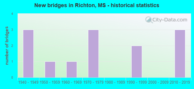
- New bridges - historical statistics
- 31940-1949
- 11950-1959
- 11960-1969
- 31970-1979
- 21990-1999
- 32010-2019


- Bridge Condition - Deck
- 25.0%Very good
- 50.0%Good
- 25.0%Satisfactory

- Bridge Condition - Superstructure
- 25.0%Excellent
- 50.0%Very good
- 25.0%Satisfactory

- Bridge Condition - Substructure
- 25.0%Excellent
- 50.0%Very good
- 25.0%Satisfactory

- Bridge Condition - Channel
- 38.5%Very good
- 46.2%Good
- 15.4%Satisfactory

- Bridge Condition - Culverts
- 11.1%Very good
- 88.9%Good
Find on map >> Show street view
Structure Number: 310001505605, Location: 3.5 MI S SR 42 WEST (Lat: 31.301525, Lng: -88.926817), Route carried "on" structure: State highway 15, Year Built: 2012, Status: Open, Structure Length: 0.98m (3.22ft), Average Daily Traffic: 1,800 (year 2020), Truck Traffic: 14%, Average Future Daily Traffic: 1,800 (year 2040), Design Load: HS 20, Features Intersected: THOMPSON CREEK TRIB
Minimum Vertical Clearance: 30+ m (98+ ft), Kilometerpoint: 15.152, Lanes on structure: 2, Base Highway Network: Yes (Inventory Route: 1, Subroute: 1), Owner: State Highway Agency, Approaching Roadway Width: 8.5m (27.9ft), Material/Design: Concrete, Design/Construction: Culvert, Number Of Spans In Main Unit: 2, Length of Maximum Span: 4.9m (16.1ft)
Condition: Channel: Very good, Culverts: Good, Inventory Rating: 78.7 metric tons, Method Used To Determine Inventory Rating: Load Factor (LF), Structural Evaluation: Better than present minimum criteria, Waterway Adequacy: Equal to present desirable criteria, Approach Roadway Alignment: Equal to present desirable criteria, Designated Inspection Frequency: Every 24 months, Inspection Date: June 2020
Find on map >> Show street view
Structure Number: 31000150560516, Location: 1.8 MI S SR 42 WEST (Lat: 31.324883, Lng: -88.934478), Route carried "on" structure: State highway 15, Year Built: 2012, Status: Open, Structure Length: 4.93m (16.17ft), Average Daily Traffic: 2,500 (year 2020), Truck Traffic: 14%, Average Future Daily Traffic: 2,500 (year 2040), Design Load: HS 20, Features Intersected: PINE BRANCH CREEK
Minimum Vertical Clearance: 30+ m (98+ ft), Kilometerpoint: 17.843, Lanes on structure: 2, Base Highway Network: Yes (Inventory Route: 1, Subroute: 1), Owner: State Highway Agency, Approaching Roadway Width: 13.4m (44.0ft), Skew: 1 degrees, Material/Design: Prestressed concrete continuous, Design/Construction: Stringer/Multi-beam, Number Of Spans In Main Unit: 4, Length of Maximum Span: 12.2m (40.0ft), Curb-To-Curb Width: 13.4m (44.0ft), Out-to-Out Width: 14.3m (46.9ft)
Condition: Deck: Good, Superstructure: Very good, Substructure: Very good, Channel: Very good, Operating Rating: 75.1 metric tons, Method Used To Determine Operating Rating: Load Factor (LF), Inventory Rating: 45.0 metric tons, Method Used To Determine Inventory Rating: Load Factor (LF), Structural Evaluation: Equal to present desirable criteria, Deck Geometry: Better than present minimum criteria, Waterway Adequacy: Equal to present desirable criteria, Approach Roadway Alignment: Equal to present desirable criteria, Designated Inspection Frequency: Every 24 months, Inspection Date: June 2020, Deck Structure Type: Concrete Cast-file-Place
Find on map >> Show street view
Structure Number: 31000150560535, Location: AT JCT SR 42 WEST (Lat: 31.350522, Lng: -88.935750), Route carried "on" structure: State highway 15, Year Built: 1940, Status: Open, Structure Length: 0.76m (2.49ft), Average Daily Traffic: 7,500 (year 2020), Truck Traffic: 14%, Average Future Daily Traffic: 7,500 (year 2040), Design Load: H 15, Features Intersected: STREAM
Minimum Vertical Clearance: 30+ m (98+ ft), Kilometerpoint: 20.902, Lanes on structure: 2, Base Highway Network: Yes (Inventory Route: 1, Subroute: 1), Owner: State Highway Agency, Approaching Roadway Width: 11.6m (38.1ft), Material/Design: Concrete, Design/Construction: Culvert, Number Of Spans In Main Unit: 2, Length of Maximum Span: 3.0m (9.8ft)
Condition: Channel: Good, Culverts: Good, Operating Rating: 33.2 metric tons, Method Used To Determine Operating Rating: Load Factor (LF), Inventory Rating: 19.9 metric tons, Method Used To Determine Inventory Rating: Load Factor (LF), Structural Evaluation: Somewhat better than minimum adequacy, Waterway Adequacy: Equal to present desirable criteria, Approach Roadway Alignment: Equal to present desirable criteria, Designated Inspection Frequency: Every 24 months, Inspection Date: June 2020
Find on map >> Show street view
Structure Number: 31000150560543, Location: 0.3 MI N SR 42 EAST (Lat: 31.362411, Lng: -88.935547), Route carried "on" structure: State highway 15, Year Built: 1968, Status: Open, Structure Length: 1.58m (5.18ft), Average Daily Traffic: 3,500 (year 2020), Truck Traffic: 13%, Average Future Daily Traffic: 3,500 (year 2040), Design Load: HS 20+Mod, Features Intersected: BEAVER DAM CREEK
Minimum Vertical Clearance: 30+ m (98+ ft), Kilometerpoint: 22.223, Lanes on structure: 2, Base Highway Network: Yes (Inventory Route: 1, Subroute: 1), Owner: State Highway Agency, Approaching Roadway Width: 13.4m (44.0ft), Skew: 3 degrees, Material/Design: Concrete, Design/Construction: Culvert, Number Of Spans In Main Unit: 3, Length of Maximum Span: 4.3m (14.1ft)
Condition: Channel: Good, Culverts: Very good, Operating Rating: 60.6 metric tons, Method Used To Determine Operating Rating: Load Factor (LF), Inventory Rating: 36.3 metric tons, Method Used To Determine Inventory Rating: Load Factor (LF), Structural Evaluation: Equal to present desirable criteria, Waterway Adequacy: Equal to present desirable criteria, Approach Roadway Alignment: Equal to present desirable criteria, Designated Inspection Frequency: Every 24 months, Inspection Date: June 2020
Find on map >> Show street view
Structure Number: 31000150560552, Location: 1.5 MI N SR 42 EAST (Lat: 31.375169, Lng: -88.935975), Route carried "on" structure: State highway 15, Year Built: 1940, Status: Open, Structure Length: 1.13m (3.71ft), Average Daily Traffic: 3,500 (year 2020), Truck Traffic: 13%, Average Future Daily Traffic: 3,500 (year 2040), Design Load: H 15, Features Intersected: THOMPSON CREEK TRIB
Minimum Vertical Clearance: 30+ m (98+ ft), Kilometerpoint: 23.638, Lanes on structure: 2, Base Highway Network: Yes (Inventory Route: 1, Subroute: 1), Owner: State Highway Agency, Approaching Roadway Width: 10.1m (33.1ft), Skew: 4 degrees, Material/Design: Concrete, Design/Construction: Culvert, Number Of Spans In Main Unit: 3, Length of Maximum Span: 3.4m (11.2ft)
Condition: Channel: Good, Culverts: Good, Operating Rating: 45.7 metric tons, Method Used To Determine Operating Rating: Load Factor (LF), Inventory Rating: 27.4 metric tons, Method Used To Determine Inventory Rating: Load Factor (LF), Structural Evaluation: Equal to present minimum criteria, Waterway Adequacy: Equal to present desirable criteria, Approach Roadway Alignment: Equal to present desirable criteria, Length Of Structure Improvement: 1.13m (3.71ft), Designated Inspection Frequency: Every 24 months, Inspection Date: June 2020, Bridge Improvement Cost: $71,000,000, Roadway Improvement Cost: $200,000,000, Total Project Cost: $280,000,000
Find on map >> Show street view
Structure Number: 31000150560556, Location: 1.9 MI N SR 42 EAST (Lat: 31.381872, Lng: -88.936672), Route carried "on" structure: State highway 15, Year Built: 1940, Status: Open, Structure Length: 0.82m (2.69ft), Average Daily Traffic: 3,500 (year 2020), Truck Traffic: 13%, Average Future Daily Traffic: 3,500 (year 2040), Design Load: H 15, Features Intersected: THOMPSON CREEK TRIB
Minimum Vertical Clearance: 30+ m (98+ ft), Kilometerpoint: 24.383, Lanes on structure: 2, Base Highway Network: Yes (Inventory Route: 1, Subroute: 1), Owner: State Highway Agency, Approaching Roadway Width: 10.4m (34.1ft), Skew: 3 degrees, Material/Design: Concrete, Design/Construction: Culvert, Number Of Spans In Main Unit: 2, Length of Maximum Span: 3.7m (12.1ft)
Condition: Channel: Very good, Culverts: Good, Operating Rating: 38.1 metric tons, Method Used To Determine Operating Rating: Load Factor (LF), Inventory Rating: 22.8 metric tons, Method Used To Determine Inventory Rating: Load Factor (LF), Structural Evaluation: Equal to present minimum criteria, Waterway Adequacy: Equal to present desirable criteria, Approach Roadway Alignment: Equal to present desirable criteria, Length Of Structure Improvement: 0.82m (2.69ft), Designated Inspection Frequency: Every 24 months, Inspection Date: June 2020, Bridge Improvement Cost: $52,000,000, Roadway Improvement Cost: $200,000,000, Total Project Cost: $280,000,000
Find on map >> Show street view
Structure Number: 31000420560828, Location: 0.7 MI E SR 15 (Lat: 31.355789, Lng: -88.924872), Route carried "on" structure: State highway 42, Year Built: 1999, Status: Open, Structure Length: 26.75m (87.76ft), Average Daily Traffic: 4,900 (year 2020), Truck Traffic: 14%, Average Future Daily Traffic: 4,900 (year 2040), Design Load: HS 20, Features Intersected: THOMPSON CREEK
Minimum Vertical Clearance: 30+ m (98+ ft), Kilometerpoint: 21.971, Lanes on structure: 2, Base Highway Network: Yes (Inventory Route: 4, Subroute: 2), Owner: State Highway Agency, Approaching Roadway Width: 17.0m (55.8ft), Material/Design: Prestressed concrete continuous, Design/Construction: Stringer/Multi-beam, Number Of Spans In Main Unit: 5, Number Of Approach Spans: 9, Length of Maximum Span: 30.0m (98.4ft), Curb-To-Curb Width: 13.2m (43.3ft), Out-to-Out Width: 14.1m (46.3ft)
Condition: Deck: Good, Superstructure: Very good, Substructure: Very good, Channel: Good, Operating Rating: 54.2 metric tons, Method Used To Determine Operating Rating: Load Factor (LF), Inventory Rating: 25.9 metric tons, Method Used To Determine Inventory Rating: Load Factor (LF), Structural Evaluation: Equal to present minimum criteria, Deck Geometry: Equal to present minimum criteria, Waterway Adequacy: Equal to present desirable criteria, Approach Roadway Alignment: Equal to present desirable criteria, Designated Inspection Frequency: Every 24 months, Inspection Date: June 2020, Deck Structure Type: Concrete Cast-file-Place
Find on map >> Show street view
Structure Number: 31000420560852, Location: 3.0 MI E SR 15 (Lat: 31.367472, Lng: -88.877139), Route carried "on" structure: State highway 42, Year Built: 1951, Status: Open, Structure Length: 0.67m (2.20ft), Average Daily Traffic: 2,700 (year 2020), Truck Traffic: 14%, Average Future Daily Traffic: 2,700 (year 2040), Design Load: H 15, Features Intersected: STREAM
Minimum Vertical Clearance: 30+ m (98+ ft), Kilometerpoint: 26.736, Lanes on structure: 2, Base Highway Network: Yes (Inventory Route: 4, Subroute: 2), Owner: State Highway Agency, Approaching Roadway Width: 8.8m (28.9ft), Material/Design: Concrete, Design/Construction: Culvert, Number Of Spans In Main Unit: 2, Length of Maximum Span: 3.0m (9.8ft)
Condition: Channel: Good, Culverts: Good, Operating Rating: 32.5 metric tons, Method Used To Determine Operating Rating: Allowable Stress (AS), Inventory Rating: 24.3 metric tons, Method Used To Determine Inventory Rating: Allowable Stress (AS), Structural Evaluation: Equal to present minimum criteria, Waterway Adequacy: Equal to present desirable criteria, Approach Roadway Alignment: Equal to present desirable criteria, Length Of Structure Improvement: 0.67m (2.20ft), Designated Inspection Frequency: Every 24 months, Inspection Date: June 2020, Bridge Improvement Cost: $42,000,000, Roadway Improvement Cost: $200,000,000, Total Project Cost: $300,000,000
Find on map >> Show street view
Structure Number: SA5600000000101, Location: SEC 8 T 5N R 9W B (Lat: 31.406953, Lng: -88.925236), Route carried "on" structure: County highway 132, Year Built: 1976, Status: Open, Structure Length: 0.76m (2.49ft), Average Daily Traffic: 280 (year 2013), Truck Traffic: 8%, Average Future Daily Traffic: 500 (year 2033), Design Load: HS 20, Features Intersected: PINE LOG BRANCH, Facility Carried by Structure: GOOD HOPE CHURCH R
Minimum Vertical Clearance: 30+ m (98+ ft), Kilometerpoint: 2.414, Lanes on structure: 2, Owner: County Highway Agency, Approaching Roadway Width: 9.1m (29.9ft), Material/Design: Concrete, Design/Construction: Culvert, Number Of Spans In Main Unit: 2, Length of Maximum Span: 3.7m (12.1ft)
Condition: Channel: Good, Culverts: Good, Operating Rating: 56.9 metric tons, Method Used To Determine Operating Rating: Load Factor (LF), Inventory Rating: 34.0 metric tons, Method Used To Determine Inventory Rating: Load Factor (LF), Structural Evaluation: Better than present minimum criteria, Waterway Adequacy: Better than present minimum criteria, Approach Roadway Alignment: Equal to present minimum criteria, Designated Inspection Frequency: Every 24 months, Inspection Date: March 2020
Find on map >> Show street view
Structure Number: SA5600000000104, Location: SEC 17 T 5N R 9W B (Lat: 31.402939, Lng: -88.922789), Route carried "on" structure: County highway 1150, Year Built: 1975, Status: Open, Structure Length: 1.01m (3.31ft), Average Daily Traffic: 570 (year 2018), Truck Traffic: 8%, Average Future Daily Traffic: 1,100 (year 2038), Design Load: HS 20, Features Intersected: PINE LOG BR, Facility Carried by Structure: ACE CARLISLE ROAD
Minimum Vertical Clearance: 30+ m (98+ ft), Kilometerpoint: 2.735, Lanes on structure: 2, Owner: County Highway Agency, Approaching Roadway Width: 10.4m (34.1ft), Material/Design: Concrete, Design/Construction: Culvert, Number Of Spans In Main Unit: 2, Length of Maximum Span: 4.9m (16.1ft)
Condition: Channel: Satisfactory, Culverts: Good, Operating Rating: 46.1 metric tons, Method Used To Determine Operating Rating: Load Factor (LF), Inventory Rating: 27.8 metric tons, Method Used To Determine Inventory Rating: Load Factor (LF), Structural Evaluation: Equal to present minimum criteria, Waterway Adequacy: Better than present minimum criteria, Approach Roadway Alignment: Equal to present desirable criteria, Designated Inspection Frequency: Every 24 months, Inspection Date: March 2020
Find on map >> Show street view
Structure Number: SA5600000000105, Location: SEC 33 T 5N R 9W B (Lat: 31.352236, Lng: -88.907219), Route carried "on" structure: County highway 40, Year Built: 1975, Status: Open, Structure Length: 1.74m (5.71ft), Average Daily Traffic: 750 (year 2021), Truck Traffic: 8%, Average Future Daily Traffic: 825 (year 2041), Design Load: H 15, Features Intersected: UNNAMED BRANCH, Facility Carried by Structure: COCHRAN ROAD
Minimum Vertical Clearance: 30+ m (98+ ft), Kilometerpoint: 0.643, Lanes on structure: 2, Owner: County Highway Agency, Approaching Roadway Width: 7.3m (24.0ft), Material/Design: Concrete, Design/Construction: Channel Beam, Number Of Spans In Main Unit: 3, Length of Maximum Span: 5.8m (19.0ft), Curb or Sidewalk Widths: Left: 0.2m (0.7ft), Right: 0.2m (0.7ft), Curb-To-Curb Width: 8.1m (26.6ft), Out-to-Out Width: 8.5m (27.9ft)
Condition: Deck: Satisfactory, Superstructure: Satisfactory, Substructure: Satisfactory, Channel: Satisfactory, Operating Rating: 53.8 metric tons, Method Used To Determine Operating Rating: Load Factor (LF) rating reported by rating factor (RF) method using MS18 loading, Inventory Rating: 32.4 metric tons, Method Used To Determine Inventory Rating: Load Factor (LF) rating reported by rating factor (RF) method using MS18 loading, Structural Evaluation: Equal to present minimum criteria, Deck Geometry: Somewhat better than minimum adequacy, Waterway Adequacy: Equal to present minimum criteria, Approach Roadway Alignment: Equal to present desirable criteria, Length Of Structure Improvement: 2.10m (6.89ft), Designated Inspection Frequency: Every 24 months, Inspection Date: January 2021, Bridge Improvement Cost: $200,000, Roadway Improvement Cost: $80,000, Total Project Cost: $280,000 ( Estimate for 2014), Deck Structure Type: Concrete Precast Panels, Wearing Surface/Protective System: Wearing Surface: Bituminous
Find on map >> Show street view
Structure Number: SA5600000000108, Location: SEC 15 T 5N R10W B (Lat: 31.401119, Lng: -88.978097), Route carried "on" structure: County highway 56, Year Built: 1990, Status: Open, Structure Length: 1.01m (3.31ft), Average Daily Traffic: 320 (year 2022), Truck Traffic: 8%, Average Future Daily Traffic: 480 (year 2042), Design Load: HS 20, Features Intersected: BEAVERDAM CREEK, Facility Carried by Structure: GATORWOOD ROAD
Minimum Vertical Clearance: 30+ m (98+ ft), Kilometerpoint: 0.482, Lanes on structure: 2, Owner: County Highway Agency, Approaching Roadway Width: 9.1m (29.9ft), Material/Design: Concrete, Design/Construction: Culvert, Number Of Spans In Main Unit: 2, Length of Maximum Span: 4.9m (16.1ft)
Condition: Channel: Very good, Culverts: Good, Operating Rating: 54.6 metric tons, Method Used To Determine Operating Rating: Load Factor (LF), Inventory Rating: 32.7 metric tons, Method Used To Determine Inventory Rating: Load Factor (LF), Structural Evaluation: Better than present minimum criteria, Waterway Adequacy: Equal to present desirable criteria, Approach Roadway Alignment: Equal to present desirable criteria, Designated Inspection Frequency: Every 24 months, Inspection Date: December 2021
Find on map >> Show street view
Structure Number: SA5600000000133, Location: SEC 31 T 5N R 9W (Lat: 31.350889, Lng: -88.937750), Route carried "on" structure: City street , Year Built: 2011, Status: Open, Structure Length: 1.22m (4.00ft), Average Daily Traffic: 30 (year 2013), Average Future Daily Traffic: 65 (year 2033), Design Load: HL 93, Features Intersected: UNNAMED TRIBUTARY, Facility Carried by Structure: HOLLY STREET
Minimum Vertical Clearance: 30+ m (98+ ft), Kilometerpoint: 0.000, Lanes on structure: 2, Owner: County Highway Agency, Approaching Roadway Width: 6.7m (22.0ft), Material/Design: Concrete, Design/Construction: Channel Beam, Number Of Spans In Main Unit: 1, Length of Maximum Span: 12.2m (40.0ft), Curb or Sidewalk Widths: Left: 0.4m (1.3ft), Right: 0.4m (1.3ft), Curb-To-Curb Width: 8.5m (27.9ft), Out-to-Out Width: 9.4m (30.8ft)
Condition: Deck: Very good, Superstructure: Excellent, Substructure: Excellent, Channel: Very good, Operating Rating: 50.5 metric tons, Method Used To Determine Operating Rating: Load and Resistance Factor Rating (LRFR) rating reported by rating factor(RF) method using HL-93 loadings, Inventory Rating: 38.9 metric tons, Method Used To Determine Inventory Rating: Load and Resistance Factor Rating (LRFR) rating reported by rating factor(RF) method using HL-93 loadings, Structural Evaluation: Superior to present desirable criteria, Deck Geometry: Better than present minimum criteria, Waterway Adequacy: Superior to present desirable criteria, Approach Roadway Alignment: Equal to present desirable criteria, Designated Inspection Frequency: Every 24 months, Inspection Date: March 2020, Deck Structure Type: Concrete Precast Panels, Wearing Surface/Protective System: Wearing Surface: Monolithic Concrete