Bridge Statistics for Richmond, Louisiana (LA)
Condition, Traffic, Stress, Structural Evaluation, Project Costs
- National Bridge Inventory (NBI) Statistics
- 14Number of bridges
- 135ft / 41.1mTotal length
- $1,200,000Total costs
- 86,906Total average daily traffic
- 21,755Total average daily truck traffic
- National Bridge Inventory (NBI) Registered Bridges for Richmond
- No street view available for this location
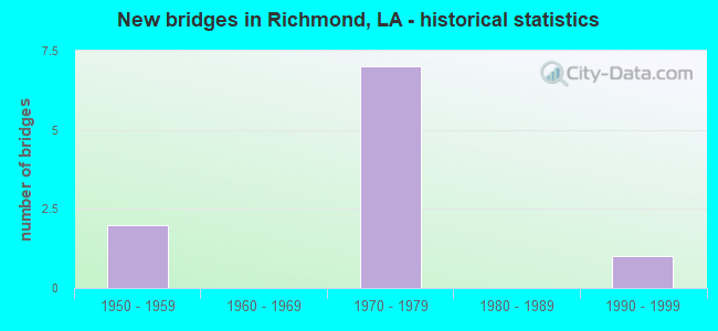
- New bridges - historical statistics
- 21950-1959
- 71970-1979
- 11990-1999


- Bridge Condition - Deck
- 28.6%Good
- 71.4%Satisfactory

- Bridge Condition - Superstructure
- 42.9%Good
- 57.1%Satisfactory

- Bridge Condition - Substructure
- 57.1%Good
- 42.9%Satisfactory

- Bridge Condition - Channel
- 87.5%Satisfactory
- 12.5%Poor

- Bridge Condition - Culverts
- 33.3%Good
- 33.3%Satisfactory
- 33.3%Fair
Find on map >> Show street view
Structure Number: 53300020503491, Location: 1.49 MI EAST OF WEST INT (Lat: 32.387450, Lng: -91.134700), Route carried "on" structure: US 80, Year Built: 1954, Status: Open, Structure Length: 1.16m (3.81ft), Average Daily Traffic: 2,700 (year 2016), Truck Traffic: 15%, Average Future Daily Traffic: 4,760 (year 2036), Design Load: HS 20, Features Intersected: GRASS LAKE
Minimum Vertical Clearance: 30+ m (98+ ft), Kilometerpoint: 5.549, Lanes on structure: 2, Owner: State Highway Agency, Approaching Roadway Width: 11.0m (36.1ft), Skew: 1 degrees, Material/Design: Concrete, Design/Construction: Culvert, Number Of Spans In Main Unit: 5, Length of Maximum Span: 1.8m (5.9ft), Curb-To-Curb Width: 11.0m (36.1ft), Out-to-Out Width: 22.9m (75.1ft)
Condition: Channel: Satisfactory, Culverts: Fair, Operating Rating: 42.1 metric tons, Method Used To Determine Operating Rating: Load and Resistance Factor Rating (LRFR) rating reported by rating factor(RF) method using HL-93 loadings, Inventory Rating: 32.4 metric tons, Method Used To Determine Inventory Rating: Load and Resistance Factor Rating (LRFR) rating reported by rating factor(RF) method using HL-93 loadings, Structural Evaluation: Somewhat better than minimum adequacy, Deck Geometry: Somewhat better than minimum adequacy, Waterway Adequacy: Equal to present desirable criteria, Approach Roadway Alignment: Equal to present desirable criteria, Designated Inspection Frequency: Every 24 months, Inspection Date: March 2021, Deck Structure Type: Concrete Cast-file-Place
Find on map >> Show street view
Structure Number: 53301820101701, Location: LA 602 OVER I-20 (Lat: 32.380839, Lng: -91.171500), Route carried "on" structure: State highway 602, Year Built: 1975, Status: Open, Structure Length: 8.47m (27.79ft), Average Daily Traffic: 1,190 (year 2016), Truck Traffic: 15%, Average Future Daily Traffic: 1,989 (year 2036), Design Load: HS 20, Features Intersected: LA 602 OVER I-20
Minimum Vertical Clearance: 30+ m (98+ ft), Kilometerpoint: 2.620, Lanes on structure: 2, Lanes under structure: 4, Owner: State Highway Agency, Approaching Roadway Width: 12.2m (40.0ft), Material/Design: Prestressed concrete, Design/Construction: Stringer/Multi-beam, Number Of Spans In Main Unit: 4, Length of Maximum Span: 26.8m (87.9ft), Curb-To-Curb Width: 12.2m (40.0ft), Out-to-Out Width: 13.0m (42.7ft)
Condition: Deck: Good, Superstructure: Satisfactory, Substructure: Good, Operating Rating: 64.4 metric tons, Method Used To Determine Operating Rating: Load Factor (LF), Inventory Rating: 38.1 metric tons, Method Used To Determine Inventory Rating: Load Factor (LF), Structural Evaluation: Equal to present minimum criteria, Deck Geometry: Better than present minimum criteria, Underclear: Better than present minimum criteria, Approach Roadway Alignment: Equal to present desirable criteria, Designated Inspection Frequency: Every 24 months, Inspection Date: March 2021, Deck Structure Type: Concrete Cast-file-Place, Wearing Surface/Protective System: Wearing Surface: Monolithic Concrete
Find on map >> Show street view
Structure Number: 53301820103261, Location: 1.56 MI SOUTH OF I-20 (Lat: 32.365319, Lng: -91.154850), Route carried "on" structure: County highway , Year Built: 1951, Status: Open, Structure Length: 2.99m (9.81ft), Average Daily Traffic: 420 (year 2011), Truck Traffic: 8%, Average Future Daily Traffic: 714 (year 2036), Design Load: H 15, Features Intersected: MILL BAYOU, Facility Carried by Structure: OLD HWY 602
Minimum Vertical Clearance: 30+ m (98+ ft), Kilometerpoint: 0.000, Lanes on structure: 2, Owner: County Highway Agency, Approaching Roadway Width: 9.1m (29.9ft), Skew: 30 degrees, Material/Design: Concrete, Design/Construction: Tee Beam, Number Of Spans In Main Unit: 4, Length of Maximum Span: 7.3m (24.0ft), Curb-To-Curb Width: 7.3m (24.0ft), Out-to-Out Width: 8.9m (29.2ft)
Condition: Deck: Satisfactory, Superstructure: Satisfactory, Substructure: Satisfactory, Channel: Poor, Operating Rating: 47.2 metric tons, Method Used To Determine Operating Rating: Load Factor (LF), Inventory Rating: 28.1 metric tons, Method Used To Determine Inventory Rating: Load Factor (LF), Structural Evaluation: Equal to present minimum criteria, Deck Geometry: Meets minimum limits, Waterway Adequacy: Equal to present minimum criteria, Approach Roadway Alignment: Equal to present desirable criteria, Designated Inspection Frequency: Every 24 months, Underwater Inspection Frequency: Every 60 months, Inspection Date: April 2021, Underwater Inspection Date: January 2020, Deck Structure Type: Concrete Cast-file-Place, Wearing Surface/Protective System: Wearing Surface: Monolithic Concrete
Find on map >> Show street view
Structure Number: 53304510817411, Location: 1.0 MI EAST OF US 65 (Lat: 32.384589, Lng: -91.184700), Route carried "on" structure: Interstate 20, Year Built: 1975, Status: Open, Structure Length: 0.98m (3.22ft), Average Daily Traffic: 24,300 (year 2016), Truck Traffic: 25%, Average Future Daily Traffic: 41,140 (year 2036), Design Load: HS 20, Features Intersected: DRAINAGE CANAL
Minimum Vertical Clearance: 30+ m (98+ ft), Kilometerpoint: 28.020, Lanes on structure: 4, Base Highway Network: Yes (Inventory Route: 451-08-1, Subroute: 10), Owner: State Highway Agency, Approaching Roadway Width: 12.8m (42.0ft), Skew: 14 degrees, Material/Design: Concrete, Design/Construction: Culvert, Number Of Spans In Main Unit: 1, Length of Maximum Span: 9.8m (32.2ft)
Condition: Channel: Satisfactory, Culverts: Satisfactory, Operating Rating: 42.1 metric tons, Method Used To Determine Operating Rating: Load and Resistance Factor Rating (LRFR) rating reported by rating factor(RF) method using HL-93 loadings, Inventory Rating: 32.4 metric tons, Method Used To Determine Inventory Rating: Load and Resistance Factor Rating (LRFR) rating reported by rating factor(RF) method using HL-93 loadings, Structural Evaluation: Equal to present minimum criteria, Waterway Adequacy: Better than present minimum criteria, Approach Roadway Alignment: Better than present minimum criteria, Designated Inspection Frequency: Every 24 months, Inspection Date: June 2021, Deck Structure Type: Concrete Cast-file-Place
Find on map >> Show street view
Structure Number: 53304510818121, Location: .01 MI WEST OF WEST INT O (Lat: 32.380700, Lng: -91.173000), Route carried "on" structure: Interstate 20, Year Built: 1975, Status: Open, Structure Length: 5.33m (17.49ft), Average Daily Traffic: 12,150 (year 2016), Truck Traffic: 25%, Average Future Daily Traffic: 24,684 (year 2036), Design Load: HS 20, Features Intersected: WALNUT BAYOU
Minimum Vertical Clearance: 30+ m (98+ ft), Kilometerpoint: 29.208, Lanes on structure: 2, Base Highway Network: Yes (Inventory Route: 451-08-1, Subroute: 10), Owner: State Highway Agency, Approaching Roadway Width: 12.2m (40.0ft), Skew: 10 degrees, Material/Design: Concrete, Design/Construction: Slab, Number Of Spans In Main Unit: 7, Length of Maximum Span: 22.9m (75.1ft), Curb-To-Curb Width: 11.9m (39.0ft), Out-to-Out Width: 12.0m (39.4ft)
Condition: Deck: Satisfactory, Superstructure: Satisfactory, Substructure: Good, Channel: Satisfactory, Operating Rating: 76.2 metric tons, Method Used To Determine Operating Rating: Load Factor (LF), Inventory Rating: 45.4 metric tons, Method Used To Determine Inventory Rating: Load Factor (LF), Structural Evaluation: Equal to present minimum criteria, Deck Geometry: Equal to present minimum criteria, Waterway Adequacy: Equal to present desirable criteria, Approach Roadway Alignment: Equal to present desirable criteria, Designated Inspection Frequency: Every 24 months, Inspection Date: June 2021, Deck Structure Type: Concrete Cast-file-Place, Wearing Surface/Protective System: Wearing Surface: Monolithic Concrete
Find on map >> Show street view
Structure Number: 53304510818122, Location: .01 MI WEST OF WEST INT O (Lat: 32.380761, Lng: -91.172400), Route carried "on" structure: Interstate 20, Year Built: 1975, Status: Open, Structure Length: 5.33m (17.49ft), Average Daily Traffic: 12,150 (year 2016), Truck Traffic: 25%, Average Future Daily Traffic: 24,684 (year 2036), Design Load: HS 20, Features Intersected: WALNUT BAYOU
Minimum Vertical Clearance: 30+ m (98+ ft), Kilometerpoint: 23.801, Lanes on structure: 2, Base Highway Network: Yes (Inventory Route: 451-08-2, Subroute: 10), Owner: State Highway Agency, Approaching Roadway Width: 12.2m (40.0ft), Skew: 10 degrees, Material/Design: Concrete, Design/Construction: Slab, Number Of Spans In Main Unit: 7, Length of Maximum Span: 7.6m (24.9ft), Curb-To-Curb Width: 11.9m (39.0ft), Out-to-Out Width: 12.0m (39.4ft)
Condition: Deck: Satisfactory, Superstructure: Satisfactory, Substructure: Good, Channel: Satisfactory, Operating Rating: 76.2 metric tons, Method Used To Determine Operating Rating: Load Factor (LF), Inventory Rating: 45.4 metric tons, Method Used To Determine Inventory Rating: Load Factor (LF), Structural Evaluation: Equal to present minimum criteria, Deck Geometry: Equal to present minimum criteria, Waterway Adequacy: Equal to present desirable criteria, Approach Roadway Alignment: Equal to present desirable criteria, Designated Inspection Frequency: Every 24 months, Inspection Date: June 2021, Deck Structure Type: Concrete Cast-file-Place, Wearing Surface/Protective System: Wearing Surface: Monolithic Concrete
Find on map >> Show street view
Structure Number: 53304510819631, Location: 1.3 MI EAST OF WEST INT O (Lat: 32.373311, Lng: -91.149700), Route carried "on" structure: Interstate 20, Year Built: 1975, Status: Open, Structure Length: 3.81m (12.50ft), Average Daily Traffic: 12,150 (year 2016), Truck Traffic: 37%, Average Future Daily Traffic: 24,684 (year 2036), Design Load: HS 20, Features Intersected: DRAINAGE CANAL
Minimum Vertical Clearance: 30+ m (98+ ft), Kilometerpoint: 31.545, Lanes on structure: 2, Base Highway Network: Yes (Inventory Route: 451-08-1, Subroute: 10), Owner: State Highway Agency, Approaching Roadway Width: 12.2m (40.0ft), Skew: 17 degrees, Material/Design: Concrete, Design/Construction: Slab, Number Of Spans In Main Unit: 5, Length of Maximum Span: 7.6m (24.9ft), Curb-To-Curb Width: 11.9m (39.0ft), Out-to-Out Width: 13.0m (42.7ft)
Condition: Deck: Satisfactory, Superstructure: Good, Substructure: Satisfactory, Channel: Satisfactory, Operating Rating: 76.2 metric tons, Method Used To Determine Operating Rating: Load Factor (LF), Inventory Rating: 45.4 metric tons, Method Used To Determine Inventory Rating: Load Factor (LF), Structural Evaluation: Equal to present minimum criteria, Deck Geometry: Equal to present minimum criteria, Waterway Adequacy: Equal to present desirable criteria, Approach Roadway Alignment: Equal to present desirable criteria, Designated Inspection Frequency: Every 24 months, Inspection Date: July 2021, Deck Structure Type: Concrete Cast-file-Place, Wearing Surface/Protective System: Wearing Surface: Monolithic Concrete
Find on map >> Show street view
Structure Number: 53304510819632, Location: 1.3 MI EAST OF WEST INT O (Lat: 32.373381, Lng: -91.149200), Route carried "on" structure: Interstate 20, Year Built: 1975, Status: Open, Structure Length: 3.81m (12.50ft), Average Daily Traffic: 12,150 (year 2016), Truck Traffic: 37%, Average Future Daily Traffic: 24,684 (year 2036), Design Load: HS 20, Features Intersected: DRAINAGE CANAL BRIDGE
Minimum Vertical Clearance: 30+ m (98+ ft), Kilometerpoint: 21.467, Lanes on structure: 2, Base Highway Network: Yes (Inventory Route: 451-08-2, Subroute: 10), Owner: State Highway Agency, Approaching Roadway Width: 12.8m (42.0ft), Skew: 17 degrees, Material/Design: Concrete, Design/Construction: Slab, Number Of Spans In Main Unit: 5, Length of Maximum Span: 7.6m (24.9ft), Curb-To-Curb Width: 11.9m (39.0ft), Out-to-Out Width: 13.0m (42.7ft)
Condition: Deck: Good, Superstructure: Good, Substructure: Satisfactory, Channel: Satisfactory, Operating Rating: 76.2 metric tons, Method Used To Determine Operating Rating: Load Factor (LF), Inventory Rating: 45.4 metric tons, Method Used To Determine Inventory Rating: Load Factor (LF), Structural Evaluation: Equal to present minimum criteria, Deck Geometry: Equal to present minimum criteria, Waterway Adequacy: Equal to present desirable criteria, Approach Roadway Alignment: Equal to present desirable criteria, Designated Inspection Frequency: Every 24 months, Inspection Date: July 2021, Deck Structure Type: Concrete Cast-file-Place, Wearing Surface/Protective System: Wearing Surface: Monolithic Concrete
Find on map >> Show street view
Structure Number: 53304510820931, Location: 2.6 MI EAST OF WEST INT O (Lat: 32.366789, Lng: -91.130100), Route carried "on" structure: County highway , Year Built: 1975, Status: Open, Structure Length: 8.47m (27.79ft), Average Daily Traffic: 2,420 (year 2015), Average Future Daily Traffic: 4,114 (year 2036), Design Load: HS 20, Features Intersected: I-20 (BARNES O'PASS), Facility Carried by Structure: BARNES CROSSING RD
Minimum Vertical Clearance: 30+ m (98+ ft), Kilometerpoint: 33.529, Lanes on structure: 2, Lanes under structure: 4, Base Highway Network: Yes (Inventory Route: 451-08-1, Subroute: 10), Owner: State Highway Agency, Approaching Roadway Width: 9.1m (29.9ft), Material/Design: Prestressed concrete, Design/Construction: Stringer/Multi-beam, Number Of Spans In Main Unit: 4, Length of Maximum Span: 26.8m (87.9ft), Curb-To-Curb Width: 7.9m (25.9ft), Out-to-Out Width: 7.9m (25.9ft)
Condition: Deck: Satisfactory, Superstructure: Good, Substructure: Good, Operating Rating: 49.0 metric tons, Method Used To Determine Operating Rating: Load Factor (LF), Inventory Rating: 29.0 metric tons, Method Used To Determine Inventory Rating: Load Factor (LF), Structural Evaluation: Better than present minimum criteria, Deck Geometry: High priority of corrective action, Underclear: Better than present minimum criteria, Approach Roadway Alignment: Equal to present desirable criteria, Length Of Structure Improvement: 9.39m (30.81ft), Designated Inspection Frequency: Every 24 months, Inspection Date: July 2021, Bridge Improvement Cost: $800,000, Total Project Cost: $1,200,000 ( Estimate for 2016), Deck Structure Type: Concrete Cast-file-Place, Wearing Surface/Protective System: Wearing Surface: Monolithic Concrete
Find on map >> Show street view
Structure Number: 53332216910791, Location: 0.1 MI S of LA 602 (Lat: 32.361789, Lng: -91.133211), Route carried "on" structure: County highway , Year Built: 1997, Status: Open, Structure Length: 0.79m (2.59ft), Average Daily Traffic: 96 (year 1979), Average Future Daily Traffic: 163 (year 2036), Design Load: HS 20, Features Intersected: BRUSHY BAYOU, Facility Carried by Structure: SAM VILLARDO RD
Minimum Vertical Clearance: 30+ m (98+ ft), Kilometerpoint: 0.000, Lanes on structure: 2, Base Highway Network: Yes, Owner: County Highway Agency, Approaching Roadway Width: 7.0m (23.0ft), Material/Design: Concrete, Design/Construction: Culvert, Number Of Spans In Main Unit: 3, Length of Maximum Span: 2.4m (7.9ft)
Condition: Channel: Satisfactory, Culverts: Good, Operating Rating: 42.1 metric tons, Method Used To Determine Operating Rating: Load and Resistance Factor Rating (LRFR) rating reported by rating factor(RF) method using HL-93 loadings, Inventory Rating: 32.4 metric tons, Method Used To Determine Inventory Rating: Load and Resistance Factor Rating (LRFR) rating reported by rating factor(RF) method using HL-93 loadings, Structural Evaluation: Better than present minimum criteria, Waterway Adequacy: Equal to present desirable criteria, Approach Roadway Alignment: Equal to present desirable criteria, Designated Inspection Frequency: Every 24 months, Inspection Date: April 2021, Deck Structure Type: Concrete Cast-file-Place
Find on map >> Show street view
Structure Number: 53301820101701, Location: 1.7 MI E OF US 65 (Lat: 32.380319, Lng: -91.171839), Route carried "under" structure: Interstate 20, Structure Length: 0. m, Average Daily Traffic: 1,170 (year 2015), Features Intersected: LA 602 OVER I-20
Minimum Vertical Clearance: 5.12m (16.80ft), Kilometerpoint: 29.324, Lanes on structure: 2, Length of Maximum Span: 0.0m
Find on map >> Show street view
Structure Number: 53301820101701, Location: 1.7 MI E OF US 65 (Lat: 32.380511, Lng: -91.171600), Route carried "under" structure: Interstate 20, Structure Length: 0. m, Average Daily Traffic: 1,170 (year 2015), Features Intersected: LA 602 OVER I-20
Minimum Vertical Clearance: 5.09m (16.70ft), Kilometerpoint: 23.723, Lanes on structure: 2, Length of Maximum Span: 0.0m
Find on map >> Show street view
Structure Number: 53304510820931, Location: 2.5 MI E OF LA 602 (Lat: 32.367261, Lng: -91.129850), Route carried "under" structure: Interstate 20, Structure Length: 0. m, Average Daily Traffic: 2,420 (year 2015), Features Intersected: BARNES RD OVER I-20
Minimum Vertical Clearance: 5.12m (16.80ft), Kilometerpoint: 19.528, Lanes on structure: 2, Length of Maximum Span: 0.0m
Find on map >> Show street view
Structure Number: 53304510820931, Location: 2.5 MI E OF LA 602 (Lat: 32.367039, Lng: -91.130039), Route carried "under" structure: Interstate 20, Structure Length: 0. m, Average Daily Traffic: 2,420 (year 2015), Features Intersected: BARNES RD OVER I-20
Minimum Vertical Clearance: 5.12m (16.80ft), Kilometerpoint: 33.526, Lanes on structure: 2, Length of Maximum Span: 0.0m