Bridge Statistics for Richford, Vermont (VT)
Condition, Traffic, Stress, Structural Evaluation, Project Costs
- National Bridge Inventory (NBI) Statistics
- 10Number of bridges
- 66ft / 19.8mTotal length
- $5,662,000Total costs
- 8,500Total average daily traffic
- 498Total average daily truck traffic
- National Bridge Inventory (NBI) Registered Bridges for Richford
- No street view available for this location
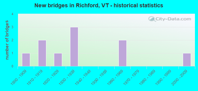
- New bridges - historical statistics
- 11900-1909
- 21910-1919
- 11920-1929
- 31930-1939
- 21960-1969
- 12000-2009

- Reconstructed bridges - Historical Statistics
- 12000-2009
- 12010-2019


- Bridge Condition - Deck
- 33.3%Very good
- 33.3%Good
- 16.7%Satisfactory
- 16.7%Failed

- Bridge Condition - Superstructure
- 50.0%Good
- 33.3%Satisfactory
- 16.7%Failed

- Bridge Condition - Substructure
- 16.7%Very good
- 33.3%Good
- 33.3%Satisfactory
- 16.7%Fair

- Bridge Condition - Channel
- 28.6%Very good
- 57.1%Good
- 14.3%Satisfactory
Find on map >> Show street view
Structure Number: 100611000506111, Location: AT JCT W CL3 TH40 (Lat: 45.009939, Lng: -72.586500), Route carried "on" structure: Other road C3031, Year Built: 1968, Status: Open, Structure Length: 1.37m (4.49ft), Average Daily Traffic: 200 (year 2019), Truck Traffic: 2%, Average Future Daily Traffic: 210 (year 2029), Design Load: H 20, Features Intersected: LUCAS BROOK
Minimum Vertical Clearance: 30+ m (98+ ft), Kilometerpoint: 0.000, Lanes on structure: 2, Owner: Town or Township Highway Agency, Approaching Roadway Width: 8.5m (27.9ft), Material/Design: Prestressed concrete, Design/Construction: Channel Beam, Number Of Spans In Main Unit: 1, Length of Maximum Span: 12.8m (42.0ft), Curb or Sidewalk Widths: Left: 0.9m (3.0ft), Right: 0.0m, Curb-To-Curb Width: 8.4m (27.6ft), Out-to-Out Width: 8.7m (28.5ft)
Condition: Deck: Good, Superstructure: Good, Substructure: Good, Channel: Good, Operating Rating: 29.9 metric tons, Method Used To Determine Operating Rating: Allowable Stress (AS), Inventory Rating: 28.1 metric tons, Method Used To Determine Inventory Rating: Allowable Stress (AS), Structural Evaluation: Better than present minimum criteria, Deck Geometry: Somewhat better than minimum adequacy, Waterway Adequacy: Better than present minimum criteria, Approach Roadway Alignment: Better than present minimum criteria, Designated Inspection Frequency: Every 24 months, Inspection Date: July 2020, Deck Structure Type: Concrete Precast Panels
Find on map >> Show street view
Structure Number: 100611002806111, Location: 0.6 MI SOUTH OF VT105 (Lat: 44.981142, Lng: -72.675072), Route carried "on" structure: Other road C3018, Year Built: 2007, Status: Open, Structure Length: 0.67m (2.20ft), Average Daily Traffic: 100 (year 2019), Truck Traffic: 2%, Average Future Daily Traffic: 105 (year 2029), Features Intersected: LOVELAND BROOK
Minimum Vertical Clearance: 30+ m (98+ ft), Kilometerpoint: 0.000, Lanes on structure: 2, Owner: Town or Township Highway Agency, Approaching Roadway Width: 7.3m (24.0ft), Skew: 2 degrees, Material/Design: Concrete, Design/Construction: Culvert, Number Of Spans In Main Unit: 1, Length of Maximum Span: 6.1m (20.0ft)
Condition: Channel: Good, Culverts: Good, Operating Rating: 68.0 metric tons, Method Used To Determine Operating Rating: Field evaluation and documented engineering judgment, Inventory Rating: 40.8 metric tons, Method Used To Determine Inventory Rating: Field evaluation and documented engineering judgment, Structural Evaluation: Better than present minimum criteria, Waterway Adequacy: Equal to present desirable criteria, Approach Roadway Alignment: Equal to present desirable criteria, Designated Inspection Frequency: Every 24 months, Inspection Date: July 2020
Find on map >> Show street view
Structure Number: 200034003006112, Location: 0.9 MI W JCT VT 139 (Lat: 44.982392, Lng: -72.684425), Route carried "on" structure: State highway 105, Year Built: 1969, Status: Temporarily open, Structure Length: 3.66m (12.01ft), Average Daily Traffic: 3,500 (year 2020), Truck Traffic: 5%, Average Future Daily Traffic: 4,000 (year 2040), Features Intersected: LOVELAND BROOK
Minimum Vertical Clearance: 30+ m (98+ ft), Kilometerpoint: 0.000, Lanes on structure: 2, Owner: State Highway Agency, Approaching Roadway Width: 9.1m (29.9ft), Material/Design: Steel, Design/Construction: Truss - Thru, Number Of Spans In Main Unit: 1, Length of Maximum Span: 36.6m (120.1ft), Curb-To-Curb Width: 7.3m (24.0ft), Out-to-Out Width: 7.3m (24.0ft)
Condition: Deck: Failed, Superstructure: Failed, Substructure: Satisfactory, Channel: Good, Waterway Adequacy: Better than present minimum criteria, Approach Roadway Alignment: Equal to present minimum criteria, Length Of Structure Improvement: 4.39m (14.40ft), Designated Inspection Frequency: Every 24 months, Inspection Date: July 2021, Bridge Improvement Cost: $1,296,000, Roadway Improvement Cost: $150,000, Total Project Cost: $1,446,000 ( Estimate for 2020), Deck Structure Type: Steel plate
Find on map >> Show street view
Structure Number: 200034003606112, Location: 0.1 MI W JCT. VT.105A E (Lat: 44.994725, Lng: -72.614206), Route carried "on" structure: State highway 105, Year Built: 1930, Status: Open, Structure Length: 1.28m (4.20ft), Average Daily Traffic: 1,000 (year 2018), Truck Traffic: 9%, Average Future Daily Traffic: 1,050 (year 2028), Design Load: H 15, Features Intersected: STANHOPE BROOK
Minimum Vertical Clearance: 30+ m (98+ ft), Kilometerpoint: 50.297, Lanes on structure: 2, Base Highway Network: Yes, Owner: State Highway Agency, Approaching Roadway Width: 11.0m (36.1ft), Skew: 2 degrees, Material/Design: Concrete, Design/Construction: Tee Beam, Number Of Spans In Main Unit: 1, Length of Maximum Span: 11.6m (38.1ft), Curb or Sidewalk Widths: Left: 0.2m (0.7ft), Right: 0.2m (0.7ft), Curb-To-Curb Width: 10.7m (35.1ft), Out-to-Out Width: 12.2m (40.0ft)
Condition: Deck: Good, Superstructure: Good, Substructure: Good, Channel: Satisfactory, Operating Rating: 49.9 metric tons, Method Used To Determine Operating Rating: Allowable Stress (AS), Inventory Rating: 28.1 metric tons, Method Used To Determine Inventory Rating: Allowable Stress (AS), Structural Evaluation: Better than present minimum criteria, Deck Geometry: Equal to present minimum criteria, Waterway Adequacy: Somewhat better than minimum adequacy, Approach Roadway Alignment: Equal to present desirable criteria, Designated Inspection Frequency: Every 24 months, Inspection Date: July 2021, Deck Structure Type: Concrete Cast-file-Place, Wearing Surface/Protective System: Wearing Surface: Bituminous
Find on map >> Show street view
Structure Number: 200302004106112, Location: 0.3 MI W JCT. VT.105 (Lat: 44.996808, Lng: -72.671928), Route carried "on" structure: County highway 2, Year Built: 1934, Year Reconstructed: 2008, Status: Open, Structure Length: 3.90m (12.80ft), Average Daily Traffic: 1,500 (year 2017), Truck Traffic: 6%, Average Future Daily Traffic: 1,575 (year 2027), Design Load: HS 20, Features Intersected: MISSISQUOI RIVER
Minimum Vertical Clearance: 6.40m (21.00ft), Kilometerpoint: 0.000, Lanes on structure: 2, Owner: Town or Township Highway Agency, Approaching Roadway Width: 13.4m (44.0ft), Material/Design: Steel, Design/Construction: Truss - Thru, Number Of Spans In Main Unit: 1, Length of Maximum Span: 38.1m (125.0ft), Curb or Sidewalk Widths: Left: 1.8m (5.9ft), Right: 1.8m (5.9ft), Curb-To-Curb Width: 8.4m (27.6ft), Out-to-Out Width: 8.6m (28.2ft)
Condition: Deck: Very good, Superstructure: Satisfactory, Substructure: Satisfactory, Channel: Very good, Operating Rating: 59.9 metric tons, Method Used To Determine Operating Rating: Load Factor (LF), Inventory Rating: 35.4 metric tons, Method Used To Determine Inventory Rating: Load Factor (LF), Structural Evaluation: Equal to present minimum criteria, Deck Geometry: Meets minimum limits, Waterway Adequacy: Equal to present desirable criteria, Approach Roadway Alignment: Equal to present desirable criteria, Length Of Structure Improvement: 3.90m (12.80ft), Designated Inspection Frequency: Every 24 months, Critical Feature Inspection Frequency: Every 24 months, Inspection Date: September 2020, Critical Feature Inspection Date: September 2020, Bridge Improvement Cost: $1,259,000, Roadway Improvement Cost: $50,000, Total Project Cost: $1,309,000 ( Estimate for 2020), Deck Structure Type: Concrete Cast-file-Place, Wearing Surface/Protective System: Wearing Surface: Bituminous, Membrane: Preformed Fabric, Deck Protection: Epoxy Coated Reinforcing
Find on map >> Show street view
Structure Number: 200611000206111, Location: 1.6 MI N JCT. VT.105 (Lat: 45.010167, Lng: -72.587761), Route carried "on" structure: Alternate State highway 105A, Year Built: 1930, Status: Open, Structure Length: 2.62m (8.60ft), Average Daily Traffic: 220 (year 2018), Truck Traffic: 3%, Average Future Daily Traffic: 231 (year 2028), Design Load: H 15, Features Intersected: LUCAS BROOK
Minimum Vertical Clearance: 30+ m (98+ ft), Kilometerpoint: 0.000, Lanes on structure: 2, Owner: State Highway Agency, Approaching Roadway Width: 7.0m (23.0ft), Material/Design: Concrete, Design/Construction: Tee Beam, Number Of Spans In Main Unit: 2, Length of Maximum Span: 12.2m (40.0ft), Curb or Sidewalk Widths: Left: 0.2m (0.7ft), Right: 0.2m (0.7ft), Curb-To-Curb Width: 6.4m (21.0ft), Out-to-Out Width: 7.2m (23.6ft)
Condition: Deck: Satisfactory, Superstructure: Satisfactory, Substructure: Fair, Channel: Good, Operating Rating: 39.0 metric tons, Method Used To Determine Operating Rating: Allowable Stress (AS), Inventory Rating: 19.1 metric tons, Method Used To Determine Inventory Rating: Allowable Stress (AS), Structural Evaluation: Somewhat better than minimum adequacy, Deck Geometry: Meets minimum limits, Waterway Adequacy: Somewhat better than minimum adequacy, Approach Roadway Alignment: Better than present minimum criteria, Length Of Structure Improvement: 3.41m (11.19ft), Designated Inspection Frequency: Every 24 months, Inspection Date: September 2021, Bridge Improvement Cost: $985,000, Roadway Improvement Cost: $150,000, Total Project Cost: $1,135,000 ( Estimate for 2020), Deck Structure Type: Concrete Cast-file-Place, Wearing Surface/Protective System: Wearing Surface: Bituminous
Find on map >> Show street view
Structure Number: 200611000306111, Location: 1.8 MI N JCT. VT.105 (Lat: 45.011756, Lng: -72.588136), Route carried "on" structure: Alternate State highway 105A, Year Built: 1929, Year Reconstructed: 2019, Status: Open, Structure Length: 6.25m (20.51ft), Average Daily Traffic: 220 (year 2018), Truck Traffic: 5%, Average Future Daily Traffic: 231 (year 2028), Design Load: H 15, Features Intersected: MISSISQUOI RIVER
Minimum Vertical Clearance: 4.57m (14.99ft), Kilometerpoint: 0.000, Lanes on structure: 2, Owner: State Highway Agency, Approaching Roadway Width: 6.4m (21.0ft), Material/Design: Steel, Design/Construction: Truss - Thru, Number Of Spans In Main Unit: 1, Number Of Approach Spans: 1, Length of Maximum Span: 45.7m (149.9ft), Curb or Sidewalk Widths: Left: 0.2m (0.7ft), Right: 0.2m (0.7ft), Curb-To-Curb Width: 6.4m (21.0ft), Out-to-Out Width: 7.3m (24.0ft)
Condition: Deck: Very good, Superstructure: Good, Substructure: Very good, Channel: Very good, Operating Rating: 19.1 metric tons, Method Used To Determine Operating Rating: Load and Resistance Factor (LRFR), Inventory Rating: 19.1 metric tons, Method Used To Determine Inventory Rating: Load and Resistance Factor (LRFR), Structural Evaluation: Somewhat better than minimum adequacy, Deck Geometry: Meets minimum limits, Waterway Adequacy: Equal to present desirable criteria, Approach Roadway Alignment: Somewhat better than minimum adequacy, Length Of Structure Improvement: 6.25m (20.51ft), Designated Inspection Frequency: Every 24 months, Critical Feature Inspection Frequency: Every 24 months, Inspection Date: September 2021, Critical Feature Inspection Date: September 2021, Bridge Improvement Cost: $1,722,000, Roadway Improvement Cost: $50,000, Total Project Cost: $1,772,000 ( Estimate for 2020), Deck Structure Type: Other, Wearing Surface/Protective System: Wearing Surface: Monolithic Concrete, Deck Protection: Epoxy Coated Reinforcing
Find on map >> Show street view
Structure Number: 100611000906111, Location: AT JCT WITH VT105A (Lat: 45.008450, Lng: -72.589303), Route carried "under" structure: Other road C3031, Year Built: 1913, Structure Length: 0. m, Average Daily Traffic: 340 (year 1998), Truck Traffic: 2%, Features Intersected: CANADIAN PACIFIC RY., Facility Carried by Structure: RAILROAD
Kilometerpoint: 0.000, Material/Design: Steel, Design/Construction: Girder and Floorbeam System, Length of Maximum Span: 19.8m (65.0ft)
Find on map >> Show street view
Structure Number: 200034003206112, Location: 1.0 MI E JCT VT 139 (Lat: 44.985864, Lng: -72.658953), Route carried "under" structure: State highway 105, Year Built: 1909, Structure Length: 0. m, Average Daily Traffic: 1,200 (year 1998), Truck Traffic: 9%, Features Intersected: MAINE/MONTRL/ATLANTIC RR, Facility Carried by Structure: RAILROAD
Kilometerpoint: 46.455, Material/Design: Steel, Design/Construction: Stringer/Multi-beam, Length of Maximum Span: 13.7m (44.9ft)
Find on map >> Show street view
Structure Number: 200611000106111, Location: 0.2 MI N JCT. VT.105 (Lat: 44.997289, Lng: -72.610925), Route carried "under" structure: Alternate State highway 105A, Year Built: 1916, Structure Length: 0. m, Average Daily Traffic: 220 (year 1998), Truck Traffic: 3%, Features Intersected: MAINE/MONTRL/ATLANTIC RR, Facility Carried by Structure: RAILROAD
Kilometerpoint: 0.000, Material/Design: Steel, Design/Construction: Stringer/Multi-beam, Length of Maximum Span: 11.6m (38.1ft)