Bridge Statistics for Richfield, Pennsylvania (PA)
Condition, Traffic, Stress, Structural Evaluation, Project Costs
- National Bridge Inventory (NBI) Statistics
- 13Number of bridges
- 52ft / 16.3mTotal length
- $3,433,000Total costs
- 13,312Total average daily traffic
- 1,226Total average daily truck traffic
- 16,362Total future (year 2031) average daily traffic
- National Bridge Inventory (NBI) Registered Bridges for Richfield
- No street view available for this location
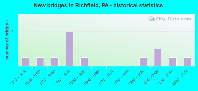
- New bridges - historical statistics
- 11910-1919
- 11920-1929
- 11930-1939
- 41940-1949
- 11950-1959
- 11990-1999
- 22000-2009
- 12010-2019
- 12020-2022

- Reconstructed bridges - Historical Statistics
- 11940-1949
- 01950-1959
- 01960-1969
- 01970-1979
- 21980-1989
- 01990-1999
- 22000-2009


- Bridge Condition - Deck
- 10.0%Excellent
- 20.0%Very good
- 10.0%Good
- 30.0%Satisfactory
- 30.0%Fair

- Bridge Condition - Superstructure
- 10.0%Excellent
- 10.0%Very good
- 20.0%Good
- 20.0%Satisfactory
- 30.0%Fair
- 10.0%Poor

- Bridge Condition - Substructure
- 20.0%Very good
- 10.0%Good
- 20.0%Satisfactory
- 50.0%Fair

- Bridge Condition - Channel
- 15.4%Very good
- 23.1%Good
- 30.8%Satisfactory
- 23.1%Fair
- 7.7%Poor

- Bridge Condition - Culverts
- 33.3%Very good
- 33.3%Good
- 33.3%Satisfactory
Find on map >> Show street view
Structure Number: 2, Location: RICHFIELD (Lat: 40.690383, Lng: -77.106889), Route carried "on" structure: State highway 35, Year Built: 1929, Status: Open, Structure Length: 2.04m (6.69ft), Average Daily Traffic: 3,425 (year 2022), Truck Traffic: 12%, Average Future Daily Traffic: 4,189 (year 2040), Design Load: H 15, Features Intersected: MAHANTANGO CREEK
Minimum Vertical Clearance: 30+ m (98+ ft), Kilometerpoint: 68.302, Lanes on structure: 2, Base Highway Network: Yes, Owner: State Highway Agency, Approaching Roadway Width: 7.6m (24.9ft), Material/Design: Concrete, Design/Construction: Tee Beam, Number Of Spans In Main Unit: 2, Length of Maximum Span: 9.8m (32.2ft), Curb or Sidewalk Widths: Left: 0.1m (0.3ft), Right: 0.1m (0.3ft), Curb-To-Curb Width: 9.2m (30.2ft), Out-to-Out Width: 10.1m (33.1ft)
Condition: Deck: Fair, Superstructure: Fair, Substructure: Fair, Channel: Fair, Operating Rating: 49.9 metric tons, Method Used To Determine Operating Rating: Allowable Stress (AS), Inventory Rating: 28.1 metric tons, Method Used To Determine Inventory Rating: Allowable Stress (AS), Structural Evaluation: Somewhat better than minimum adequacy, Deck Geometry: Meets minimum limits, Waterway Adequacy: Equal to present minimum criteria, Approach Roadway Alignment: Equal to present desirable criteria, Length Of Structure Improvement: 2.00m (6.56ft), Designated Inspection Frequency: Every 24 months, Inspection Date: April 2020, Bridge Improvement Cost: $42,000, Roadway Improvement Cost: $250,000, Total Project Cost: $564,000, Deck Structure Type: Concrete Cast-file-Place, Wearing Surface/Protective System: Wearing Surface: Bituminous
Find on map >> Show street view
Structure Number: 20048, Location: 1 MI NE SEVEN STARS (Lat: 40.618297, Lng: -77.132061), Route carried "on" structure: State highway 235, Year Built: 1936, Year Reconstructed: 1949, Status: Posted for load-capacity, Structure Length: 1.58m (5.18ft), Average Daily Traffic: 442 (year 2020), Truck Traffic: 6%, Average Future Daily Traffic: 552 (year 2041), Design Load: H 20, Features Intersected: STONEY RUN
Minimum Vertical Clearance: 30+ m (98+ ft), Kilometerpoint: 10.594, Lanes on structure: 2, Owner: State Highway Agency, Approaching Roadway Width: 6.1m (20.0ft), Material/Design: Steel, Design/Construction: Stringer/Multi-beam, Number Of Spans In Main Unit: 1, Length of Maximum Span: 15.2m (49.9ft), Curb or Sidewalk Widths: Left: 0.2m (0.7ft), Right: 0.2m (0.7ft), Curb-To-Curb Width: 7.3m (24.0ft), Out-to-Out Width: 8.1m (26.6ft)
Condition: Deck: Satisfactory, Superstructure: Fair, Substructure: Satisfactory, Channel: Fair, Operating Rating: 34.5 metric tons, Method Used To Determine Operating Rating: Load Factor (LF), Inventory Rating: 20.9 metric tons, Method Used To Determine Inventory Rating: Load Factor (LF), Structural Evaluation: Somewhat better than minimum adequacy, Deck Geometry: Meets minimum limits, Waterway Adequacy: Equal to present minimum criteria, Approach Roadway Alignment: Equal to present desirable criteria, Bridge Posting: Required (Relationship of Operating Rating to Maximum Legal Load: 10.0 - 19.9% below), Length Of Structure Improvement: 1.60m (5.25ft), Designated Inspection Frequency: Every 24 months, Other Special Inspection Frequency: Every 12 months, Inspection Date: March 2021, Other Special Inspection Date: March 2021, Bridge Improvement Cost: $49,000, Roadway Improvement Cost: $250,000, Total Project Cost: $666,000, Deck Structure Type: Concrete Cast-file-Place, Wearing Surface/Protective System: Wearing Surface: Bituminous
Find on map >> Show street view
Structure Number: 20169, Location: 1 MI E RICHFIELD (Lat: 40.688831, Lng: -77.101542), Route carried "on" structure: State highway , Year Built: 1940, Year Reconstructed: 1980, Status: Open, Structure Length: 2.65m (8.69ft), Average Daily Traffic: 497 (year 2022), Truck Traffic: 8%, Average Future Daily Traffic: 580 (year 2040), Design Load: H 20, Features Intersected: MAHANTANGO CREEK, Facility Carried by Structure: SR 2016
Minimum Vertical Clearance: 30+ m (98+ ft), Kilometerpoint: 0.000, Lanes on structure: 2, Owner: State Highway Agency, Approaching Roadway Width: 6.4m (21.0ft), Skew: 3 degrees, Material/Design: Steel, Design/Construction: Stringer/Multi-beam, Number Of Spans In Main Unit: 2, Length of Maximum Span: 12.8m (42.0ft), Curb or Sidewalk Widths: Left: 0.2m (0.7ft), Right: 0.2m (0.7ft), Curb-To-Curb Width: 6.7m (22.0ft), Out-to-Out Width: 7.8m (25.6ft)
Condition: Deck: Satisfactory, Superstructure: Fair, Substructure: Fair, Channel: Poor, Operating Rating: 64.4 metric tons, Method Used To Determine Operating Rating: Load Factor (LF), Inventory Rating: 38.1 metric tons, Method Used To Determine Inventory Rating: Load Factor (LF), Structural Evaluation: Somewhat better than minimum adequacy, Deck Geometry: Meets minimum limits, Waterway Adequacy: Better than present minimum criteria, Approach Roadway Alignment: Equal to present desirable criteria, Length Of Structure Improvement: 2.70m (8.86ft), Designated Inspection Frequency: Every 24 months, Inspection Date: April 2020, Bridge Improvement Cost: $32,000, Roadway Improvement Cost: $250,000, Total Project Cost: $430,000, Deck Structure Type: Concrete Cast-file-Place, Wearing Surface/Protective System: Wearing Surface: Monolithic Concrete
Find on map >> Show street view
Structure Number: 20184, Location: 3 MI S RICHFIELD (Lat: 40.659719, Lng: -77.080775), Route carried "on" structure: State highway , Year Built: 1990, Status: Open, Structure Length: 0.67m (2.20ft), Average Daily Traffic: 400 (year 2021), Truck Traffic: 8%, Average Future Daily Traffic: 415 (year 2040), Design Load: HS 25 or greater, Features Intersected: QUAKER RUN, Facility Carried by Structure: SR 2018
Minimum Vertical Clearance: 30+ m (98+ ft), Kilometerpoint: 5.195, Lanes on structure: 2, Owner: State Highway Agency, Approaching Roadway Width: 6.1m (20.0ft), Skew: 4 degrees, Material/Design: Concrete, Design/Construction: Culvert, Number Of Spans In Main Unit: 1, Length of Maximum Span: 6.7m (22.0ft), Curb-To-Curb Width: 9.1m (29.9ft), Out-to-Out Width: 9.1m (29.9ft)
Condition: Channel: Satisfactory, Culverts: Good, Operating Rating: 77.1 metric tons, Method Used To Determine Operating Rating: Load Factor (LF), Inventory Rating: 45.4 metric tons, Method Used To Determine Inventory Rating: Load Factor (LF), Structural Evaluation: Better than present minimum criteria, Deck Geometry: Equal to present minimum criteria, Waterway Adequacy: Better than present minimum criteria, Approach Roadway Alignment: Equal to present desirable criteria, Length Of Structure Improvement: 0.70m (2.30ft), Designated Inspection Frequency: Every 24 months, Inspection Date: April 2020
Find on map >> Show street view
Structure Number: 2019, Location: 1.5 MI SE RICHFIELD (Lat: 40.680181, Lng: -77.097361), Route carried "on" structure: State highway , Year Built: 1940, Status: Posted for load, Structure Length: 1.19m (3.90ft), Average Daily Traffic: 941 (year 2022), Truck Traffic: 10%, Average Future Daily Traffic: 1,147 (year 2041), Design Load: H 20, Features Intersected: MAHANTANGO CREEK, Facility Carried by Structure: SR 2019
Minimum Vertical Clearance: 30+ m (98+ ft), Kilometerpoint: 9.967, Lanes on structure: 2, Owner: State Highway Agency, Approaching Roadway Width: 6.7m (22.0ft), Skew: 3 degrees, Material/Design: Steel, Design/Construction: Stringer/Multi-beam, Number Of Spans In Main Unit: 2, Length of Maximum Span: 5.8m (19.0ft), Curb or Sidewalk Widths: Left: 0.2m (0.7ft), Right: 0.2m (0.7ft), Curb-To-Curb Width: 6.7m (22.0ft), Out-to-Out Width: 7.3m (24.0ft)
Condition: Deck: Fair, Superstructure: Poor, Substructure: Fair, Channel: Fair, Operating Rating: 30.8 metric tons, Method Used To Determine Operating Rating: Load Factor (LF), Inventory Rating: 18.1 metric tons, Method Used To Determine Inventory Rating: Load Factor (LF), Structural Evaluation: Meets minimum limits, Deck Geometry: Meets minimum limits, Waterway Adequacy: Equal to present minimum criteria, Approach Roadway Alignment: Meets minimum limits, Bridge Posting: Required (Relationship of Operating Rating to Maximum Legal Load: 20.0 - 29.9% below), Length Of Structure Improvement: 1.20m (3.94ft), Designated Inspection Frequency: Every 24 months, Other Special Inspection Frequency: Every 12 months, Inspection Date: March 2020, Other Special Inspection Date: March 2021, Bridge Improvement Cost: $42,000, Roadway Improvement Cost: $250,000, Total Project Cost: $564,000, Deck Structure Type: Closed Grating, Wearing Surface/Protective System: Wearing Surface: Monolithic Concrete
Find on map >> Show street view
Structure Number: 31314, Location: BOROUGH OF RICHFIELD (Lat: 40.690678, Lng: -77.112000), Route carried "on" structure: City street , Year Built: 1948, Year Reconstructed: 1987, Status: Posted for load, Structure Length: 0.85m (2.79ft), Average Daily Traffic: 75 (year 2009), Truck Traffic: 5%, Average Future Daily Traffic: 115 (year 2031), Features Intersected: W. BR. MAHANTANGO, Facility Carried by Structure: CHURCH ST (T-308
Minimum Vertical Clearance: 30+ m (98+ ft), Kilometerpoint: 0.000, Lanes on structure: 2, Owner: Town or Township Highway Agency, Approaching Roadway Width: 4.6m (15.1ft), Material/Design: Steel, Design/Construction: Stringer/Multi-beam, Number Of Spans In Main Unit: 1, Length of Maximum Span: 7.6m (24.9ft), Curb-To-Curb Width: 5.9m (19.4ft), Out-to-Out Width: 6.0m (19.7ft)
Condition: Deck: Satisfactory, Superstructure: Satisfactory, Substructure: Fair, Channel: Good, Operating Rating: 39.0 metric tons, Method Used To Determine Operating Rating: Load Factor (LF), Inventory Rating: 23.6 metric tons, Method Used To Determine Inventory Rating: Load Factor (LF), Structural Evaluation: Somewhat better than minimum adequacy, Deck Geometry: Meets minimum limits, Waterway Adequacy: Equal to present minimum criteria, Approach Roadway Alignment: Equal to present minimum criteria, Bridge Posting: Required (Relationship of Operating Rating to Maximum Legal Load: 20.0 - 29.9% below), Length Of Structure Improvement: 0.90m (2.95ft), Designated Inspection Frequency: Every 24 months, Other Special Inspection Frequency: Every 12 months, Inspection Date: September 2021, Other Special Inspection Date: September 2021, Bridge Improvement Cost: $15,000, Roadway Improvement Cost: $50,000, Total Project Cost: $198,000, Deck Structure Type: Corrugated Steel, Wearing Surface/Protective System: Wearing Surface: Bituminous
Find on map >> Show street view
Structure Number: 31316, Location: 2 MI SE OF RICHFIELD (Lat: 40.679206, Lng: -77.072036), Route carried "on" structure: City street , Year Built: 1955, Year Reconstructed: 2012, Status: Open, Structure Length: 0.91m (2.99ft), Average Daily Traffic: 50 (year 2009), Truck Traffic: 5%, Average Future Daily Traffic: 77 (year 2031), Design Load: HS 20, Features Intersected: W. BR. MAHANTANGO CREEK, Facility Carried by Structure: W. PERRY TWP. T314
Minimum Vertical Clearance: 30+ m (98+ ft), Kilometerpoint: 0.000, Lanes on structure: 2, Owner: Town or Township Highway Agency, Approaching Roadway Width: 4.6m (15.1ft), Material/Design: Steel, Design/Construction: Stringer/Multi-beam, Number Of Spans In Main Unit: 2, Length of Maximum Span: 4.3m (14.1ft), Curb or Sidewalk Widths: Left: 0.2m (0.7ft), Right: 0.2m (0.7ft), Curb-To-Curb Width: 4.9m (16.1ft), Out-to-Out Width: 5.5m (18.0ft)
Condition: Deck: Very good, Superstructure: Good, Substructure: Good, Channel: Satisfactory, Inventory Rating: 68.0 metric tons, Method Used To Determine Inventory Rating: Assigned rating based on Load Factor Design (LFD) reported in metric tons, Structural Evaluation: Better than present minimum criteria, Deck Geometry: High priority of corrective action, Waterway Adequacy: Equal to present minimum criteria, Approach Roadway Alignment: Equal to present minimum criteria, Length Of Structure Improvement: 0.90m (2.95ft), Designated Inspection Frequency: Every 24 months, Inspection Date: September 2021, Bridge Improvement Cost: $15,000, Roadway Improvement Cost: $50,000, Total Project Cost: $204,000, Deck Structure Type: Concrete Cast-file-Place, Wearing Surface/Protective System: Wearing Surface: Monolithic Concrete, Deck Protection: Epoxy Coated Reinforcing
Find on map >> Show street view
Structure Number: 31317, Location: 0.5 MI SE OF RICHFIELD (Lat: 40.683633, Lng: -77.098231), Route carried "on" structure: City street , Year Built: 1946, Year Reconstructed: 2012, Status: Open, Structure Length: 0.94m (3.08ft), Average Daily Traffic: 50 (year 2009), Truck Traffic: 5%, Average Future Daily Traffic: 77 (year 2031), Design Load: HS 20, Features Intersected: W. BR. MAHANTANGO CREEK, Facility Carried by Structure: W. PERRY TWP. T349
Minimum Vertical Clearance: 30+ m (98+ ft), Kilometerpoint: 0.000, Lanes on structure: 2, Owner: Town or Township Highway Agency, Approaching Roadway Width: 4.9m (16.1ft), Material/Design: Steel, Design/Construction: Stringer/Multi-beam, Number Of Spans In Main Unit: 1, Length of Maximum Span: 8.5m (27.9ft), Curb or Sidewalk Widths: Left: 0.2m (0.7ft), Right: 0.2m (0.7ft), Curb-To-Curb Width: 4.9m (16.1ft), Out-to-Out Width: 5.2m (17.1ft)
Condition: Deck: Very good, Superstructure: Good, Substructure: Satisfactory, Channel: Satisfactory, Operating Rating: 88.9 metric tons, Method Used To Determine Operating Rating: Assigned rating based on Load Factor Design (LFD) reported in metric tons, Inventory Rating: 53.5 metric tons, Method Used To Determine Inventory Rating: Assigned rating based on Load Factor Design (LFD) reported in metric tons, Structural Evaluation: Equal to present minimum criteria, Deck Geometry: High priority of corrective action, Waterway Adequacy: Equal to present minimum criteria, Approach Roadway Alignment: Somewhat better than minimum adequacy, Length Of Structure Improvement: 0.80m (2.62ft), Designated Inspection Frequency: Every 24 months, Inspection Date: September 2021, Bridge Improvement Cost: $60,000, Roadway Improvement Cost: $176,000, Total Project Cost: $807,000, Deck Structure Type: Concrete Cast-file-Place, Wearing Surface/Protective System: Wearing Surface: Monolithic Concrete, Deck Protection: Epoxy Coated Reinforcing
Find on map >> Show street view
Structure Number: 42453, Location: 2 MI NORTH EAST COCOLAMUS (Lat: 40.669072, Lng: -77.184828), Route carried "on" structure: State highway 35, Year Built: 2004, Status: Open, Structure Length: 0.64m (2.10ft), Average Daily Traffic: 3,321 (year 2020), Truck Traffic: 12%, Average Future Daily Traffic: 4,317 (year 2040), Design Load: HL 93, Features Intersected: TRIB COCOLAMUS CREEK
Minimum Vertical Clearance: 30+ m (98+ ft), Kilometerpoint: 62.509, Lanes on structure: 2, Base Highway Network: Yes, Owner: State Highway Agency, Approaching Roadway Width: 7.9m (25.9ft), Skew: 3 degrees, Material/Design: Concrete, Design/Construction: Culvert, Number Of Spans In Main Unit: 1, Length of Maximum Span: 6.4m (21.0ft), Curb-To-Curb Width: 13.4m (44.0ft), Out-to-Out Width: 14.7m (48.2ft)
Condition: Channel: Good, Culverts: Very good, Operating Rating: 63.5 metric tons, Method Used To Determine Operating Rating: Load Factor (LF), Inventory Rating: 49.0 metric tons, Method Used To Determine Inventory Rating: Load Factor (LF), Structural Evaluation: Equal to present desirable criteria, Deck Geometry: Better than present minimum criteria, Waterway Adequacy: Equal to present minimum criteria, Approach Roadway Alignment: Equal to present desirable criteria, Length Of Structure Improvement: 1.20m (3.94ft), Designated Inspection Frequency: Every 24 months, Inspection Date: April 2020
Find on map >> Show street view
Structure Number: 44074, Location: MOUNT PLEASANT MILLS (Lat: 40.690572, Lng: -77.106458), Route carried "on" structure: State highway 35, Year Built: 2007, Status: Open, Structure Length: 1.77m (5.81ft), Average Daily Traffic: 3,661 (year 2022), Truck Traffic: 6%, Average Future Daily Traffic: 4,373 (year 2032), Design Load: HL 93, Features Intersected: NO BRANCH MAHANTANGO CRK
Minimum Vertical Clearance: 30+ m (98+ ft), Kilometerpoint: 8.481, Lanes on structure: 2, Base Highway Network: Yes, Owner: State Highway Agency, Approaching Roadway Width: 9.1m (29.9ft), Material/Design: Prestressed concrete, Design/Construction: Box Beam or Girders - Multiple, Number Of Spans In Main Unit: 1, Length of Maximum Span: 17.4m (57.1ft), Curb or Sidewalk Widths: Left: 1.5m (4.9ft), Right: 1.5m (4.9ft), Curb-To-Curb Width: 10.0m (32.8ft), Out-to-Out Width: 13.6m (44.6ft)
Condition: Deck: Good, Superstructure: Very good, Substructure: Very good, Channel: Very good, Operating Rating: 95.3 metric tons, Method Used To Determine Operating Rating: Load and Resistance Factor (LRFR), Inventory Rating: 50.8 metric tons, Method Used To Determine Inventory Rating: Load and Resistance Factor (LRFR), Structural Evaluation: Equal to present desirable criteria, Deck Geometry: Meets minimum limits, Waterway Adequacy: Equal to present desirable criteria, Approach Roadway Alignment: Better than present minimum criteria, Designated Inspection Frequency: Every 48 months, Inspection Date: March 2020, Deck Structure Type: Concrete Cast-file-Place, Wearing Surface/Protective System: Wearing Surface: Epoxy Overlay, Deck Protection: Epoxy Coated Reinforcing
Find on map >> Show street view
Structure Number: 52717, Location: 1 MI.SE OF RICHFIELD (Lat: 40.677756, Lng: -77.096189), Route carried "on" structure: City street , Year Built: 2015, Status: Open, Structure Length: 1.19m (3.90ft), Average Daily Traffic: 250 (year 2014), Average Future Daily Traffic: 250 (year 2034), Design Load: HL 93, Features Intersected: W. BRANCH MAHANTANGO CR., Facility Carried by Structure: T-508 CRATER HILL
Minimum Vertical Clearance: 30+ m (98+ ft), Kilometerpoint: 0.000, Lanes on structure: 2, Owner: Town or Township Highway Agency, Approaching Roadway Width: 7.3m (24.0ft), Skew: 2 degrees, Material/Design: Concrete, Design/Construction: Box Beam or Girders - Single/Spread, Number Of Spans In Main Unit: 1, Length of Maximum Span: 11.3m (37.1ft), Curb or Sidewalk Widths: Left: 0.6m (2.0ft), Right: 0.6m (2.0ft), Curb-To-Curb Width: 7.3m (24.0ft), Out-to-Out Width: 8.4m (27.6ft)
Condition: Deck: Excellent, Superstructure: Excellent, Substructure: Very good, Channel: Very good, Operating Rating: 53.5 metric tons, Method Used To Determine Operating Rating: Assigned ratings based on Load and Resistance Factor Design (LRFD) reported by rating factor (RF) using HL93 loadings, Inventory Rating: 41.5 metric tons, Method Used To Determine Inventory Rating: Assigned ratings based on Load and Resistance Factor Design (LRFD) reported by rating factor (RF) using HL93 loadings, Structural Evaluation: Equal to present desirable criteria, Deck Geometry: Somewhat better than minimum adequacy, Waterway Adequacy: Better than present minimum criteria, Approach Roadway Alignment: Meets minimum limits, Designated Inspection Frequency: Every 24 months, Inspection Date: September 2021, Deck Structure Type: Concrete Cast-file-Place, Wearing Surface/Protective System: Wearing Surface: Monolithic Concrete, Deck Protection: Epoxy Coated Reinforcing
Find on map >> Show street view
Structure Number: 67755, Location: 300 FT S OF SR 35 (Lat: 40.666361, Lng: -77.187889), Route carried "on" structure: City street 545, Year Built: 1919, Status: Open, Structure Length: 0.76m (2.49ft), Average Daily Traffic: 100 (year 2020), Average Future Daily Traffic: 120 (year 2040), Design Load: HS 20, Features Intersected: COCOLAMUS CREEK, Facility Carried by Structure: LITTLE EVENDALE RD
Minimum Vertical Clearance: 30+ m (98+ ft), Kilometerpoint: 0.000, Lanes on structure: 2, Owner: Town or Township Highway Agency, Approaching Roadway Width: 3.7m (12.1ft), Skew: 3 degrees, Material/Design: Concrete, Design/Construction: Tee Beam, Number Of Spans In Main Unit: 1, Length of Maximum Span: 7.3m (24.0ft), Curb-To-Curb Width: 7.0m (23.0ft), Out-to-Out Width: 7.9m (25.9ft)
Condition: Deck: Fair, Superstructure: Satisfactory, Substructure: Fair, Channel: Satisfactory, Operating Rating: 79.8 metric tons, Method Used To Determine Operating Rating: Field evaluation and documented engineering judgment, Inventory Rating: 48.1 metric tons, Method Used To Determine Inventory Rating: Field evaluation and documented engineering judgment, Structural Evaluation: Somewhat better than minimum adequacy, Deck Geometry: Somewhat better than minimum adequacy, Waterway Adequacy: Better than present minimum criteria, Approach Roadway Alignment: Equal to present minimum criteria, Designated Inspection Frequency: Every 24 months, Inspection Date: November 2021, Deck Structure Type: Concrete Cast-file-Place, Wearing Surface/Protective System: Wearing Surface: Monolithic Concrete
Find on map >> Show street view
Structure Number: 67757, Location: 100 FT W OF SR 2017 (Lat: 40.644639, Lng: -77.145583), Route carried "on" structure: City street 479, Year Built: 2020, Status: Open, Structure Length: 1.07m (3.51ft), Average Daily Traffic: 100 (year 2020), Average Future Daily Traffic: 150 (year 2040), Design Load: H 20, Features Intersected: STONY RUN, Facility Carried by Structure: PAGE VALLEY RD
Minimum Vertical Clearance: 30+ m (98+ ft), Kilometerpoint: 0.000, Lanes on structure: 2, Owner: Town or Township Highway Agency, Approaching Roadway Width: 5.8m (19.0ft), Skew: 9 degrees, Design/Construction: Culvert, Number Of Spans In Main Unit: 1, Length of Maximum Span: 7.6m (24.9ft), Curb-To-Curb Width: 8.4m (27.6ft), Out-to-Out Width: 8.4m (27.6ft)
Condition: Channel: Good, Culverts: Satisfactory, Operating Rating: 49.0 metric tons, Method Used To Determine Operating Rating: Field evaluation and documented engineering judgment, Inventory Rating: 32.7 metric tons, Method Used To Determine Inventory Rating: Field evaluation and documented engineering judgment, Structural Evaluation: Equal to present minimum criteria, Deck Geometry: Equal to present minimum criteria, Waterway Adequacy: Better than present minimum criteria, Approach Roadway Alignment: Equal to present desirable criteria, Designated Inspection Frequency: Every 24 months, Inspection Date: November 2021