Bridge Statistics for Richburg, South Carolina (SC)
Condition, Traffic, Stress, Structural Evaluation, Project Costs
- National Bridge Inventory (NBI) Statistics
- 28Number of bridges
- 525ft / 160mTotal length
- $7,286,000Total costs
- 257,925Total average daily traffic
- 47,329Total average daily truck traffic
- National Bridge Inventory (NBI) Registered Bridges for Richburg
- No street view available for this location
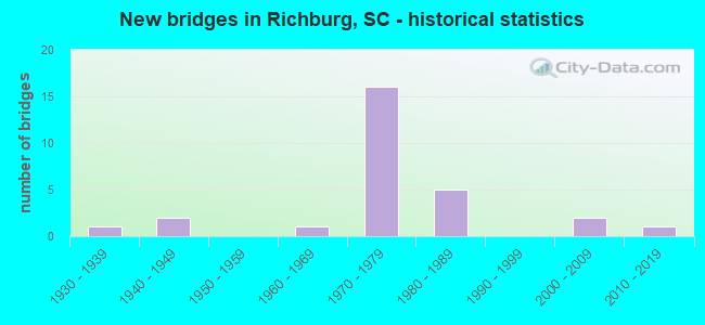
- New bridges - historical statistics
- 11930-1939
- 21940-1949
- 11960-1969
- 161970-1979
- 51980-1989
- 22000-2009
- 12010-2019


- Bridge Condition - Deck
- 21.1%Very good
- 31.6%Good
- 26.3%Satisfactory
- 21.1%Fair

- Bridge Condition - Superstructure
- 21.1%Very good
- 52.6%Good
- 21.1%Satisfactory
- 5.3%Fair

- Bridge Condition - Substructure
- 21.1%Very good
- 47.4%Good
- 26.3%Satisfactory
- 5.3%Fair

- Bridge Condition - Channel
- 38.5%Very good
- 23.1%Good
- 15.4%Satisfactory
- 15.4%Fair
- 7.7%Poor

- Bridge Condition - Culverts
- 50.0%Satisfactory
- 50.0%Fair
Find on map >> Show street view
Structure Number: 774, Location: TOWN OF LANDO (Lat: 34.776086, Lng: -81.005453), Route carried "on" structure: State highway 901, Year Built: 1937, Status: Open, Structure Length: 10.42m (34.19ft), Average Daily Traffic: 2,100 (year 2021), Truck Traffic: 5%, Average Future Daily Traffic: 3,066 (year 2041), Design Load: H 15, Features Intersected: FISHING CREEK
Minimum Vertical Clearance: 30+ m (98+ ft), Kilometerpoint: 28.909, Lanes on structure: 2, Owner: State Highway Agency, Approaching Roadway Width: 10.7m (35.1ft), Material/Design: Concrete continuous, Design/Construction: Tee Beam, Number Of Spans In Main Unit: 6, Length of Maximum Span: 17.4m (57.1ft), Curb-To-Curb Width: 6.8m (22.3ft), Out-to-Out Width: 7.2m (23.6ft)
Condition: Deck: Satisfactory, Superstructure: Satisfactory, Substructure: Satisfactory, Channel: Satisfactory, Operating Rating: 14.3 metric tons, Method Used To Determine Operating Rating: Load and Resistance Factor Rating (LRFR) rating reported by rating factor(RF) method using HL-93 loadings, Inventory Rating: 11.0 metric tons, Method Used To Determine Inventory Rating: Load and Resistance Factor Rating (LRFR) rating reported by rating factor(RF) method using HL-93 loadings, Structural Evaluation: High priority of replacement, Deck Geometry: High priority of replacement, Waterway Adequacy: Equal to present desirable criteria, Approach Roadway Alignment: Equal to present desirable criteria, Bridge Posting: Required (Relationship of Operating Rating to Maximum Legal Load: > 39.9% below), Length Of Structure Improvement: 11.46m (37.60ft), Designated Inspection Frequency: Every 24 months, Inspection Date: March 2020, Bridge Improvement Cost: $1,156,000, Roadway Improvement Cost: $289,000, Total Project Cost: $1,734,000 ( Estimate for 2022), Deck Structure Type: Concrete Cast-file-Place, Wearing Surface/Protective System: Wearing Surface: Monolithic Concrete
Find on map >> Show street view
Structure Number: 1432, Location: 2.2 MI E OF RICHBURG (Lat: 34.740872, Lng: -80.986544), Route carried "on" structure: State highway 223, Year Built: 2005, Status: Open, Structure Length: 14.02m (46.00ft), Average Daily Traffic: 1,500 (year 2020), Truck Traffic: 16%, Average Future Daily Traffic: 2,190 (year 2040), Design Load: HL 93, Features Intersected: FISHING CREEK
Minimum Vertical Clearance: 30+ m (98+ ft), Kilometerpoint: 3.462, Lanes on structure: 2, Owner: State Highway Agency, Approaching Roadway Width: 9.8m (32.2ft), Material/Design: Prestressed concrete continuous, Design/Construction: Stringer/Multi-beam, Number Of Spans In Main Unit: 3, Number Of Approach Spans: 2, Length of Maximum Span: 30.5m (100.1ft), Curb-To-Curb Width: 13.4m (44.0ft), Out-to-Out Width: 14.3m (46.9ft)
Condition: Deck: Very good, Superstructure: Very good, Substructure: Very good, Channel: Good, Operating Rating: 39.5 metric tons, Method Used To Determine Operating Rating: Load and Resistance Factor Rating (LRFR) rating reported by rating factor(RF) method using HL-93 loadings, Inventory Rating: 30.5 metric tons, Method Used To Determine Inventory Rating: Load and Resistance Factor Rating (LRFR) rating reported by rating factor(RF) method using HL-93 loadings, Structural Evaluation: Better than present minimum criteria, Deck Geometry: Equal to present desirable criteria, Waterway Adequacy: Equal to present desirable criteria, Approach Roadway Alignment: Equal to present desirable criteria, Length Of Structure Improvement: 14.02m (46.00ft), Designated Inspection Frequency: Every 24 months, Inspection Date: March 2020, Deck Structure Type: Concrete Cast-file-Place, Wearing Surface/Protective System: Wearing Surface: Monolithic Concrete
Find on map >> Show street view
Structure Number: 1434, Location: 2.3MI W RICHBURG (Lat: 34.719367, Lng: -81.061808), Route carried "on" structure: State highway 56, Year Built: 1948, Status: Open, Structure Length: 0.63m (2.07ft), Average Daily Traffic: 700 (year 2020), Truck Traffic: 11%, Average Future Daily Traffic: 1,022 (year 2040), Design Load: H 15, Features Intersected: HOOPER CREEK
Minimum Vertical Clearance: 30+ m (98+ ft), Kilometerpoint: 8.071, Lanes on structure: 2, Owner: State Highway Agency, Approaching Roadway Width: 10.7m (35.1ft), Material/Design: Concrete, Design/Construction: Culvert, Number Of Spans In Main Unit: 2, Length of Maximum Span: 3.0m (9.8ft), Curb-To-Curb Width: 10.7m (35.1ft), Out-to-Out Width: 15.8m (51.8ft)
Condition: Channel: Fair, Culverts: Satisfactory, Operating Rating: 54.8 metric tons, Method Used To Determine Operating Rating: Load and Resistance Factor Rating (LRFR) rating reported by rating factor(RF) method using HL-93 loadings, Inventory Rating: 42.4 metric tons, Method Used To Determine Inventory Rating: Load and Resistance Factor Rating (LRFR) rating reported by rating factor(RF) method using HL-93 loadings, Structural Evaluation: Equal to present minimum criteria, Deck Geometry: Equal to present minimum criteria, Waterway Adequacy: Better than present minimum criteria, Approach Roadway Alignment: Equal to present desirable criteria, Length Of Structure Improvement: 0.63m (2.07ft), Designated Inspection Frequency: Every 24 months, Inspection Date: March 2021
Find on map >> Show street view
Structure Number: 1435, Location: 1.4 MI W RICHBURG (Lat: 34.716400, Lng: -81.046808), Route carried "on" structure: State highway 56, Year Built: 1948, Status: Open, Structure Length: 0.67m (2.20ft), Average Daily Traffic: 950 (year 2020), Truck Traffic: 14%, Average Future Daily Traffic: 1,387 (year 2040), Design Load: H 20, Features Intersected: BARBER CREEK
Minimum Vertical Clearance: 30+ m (98+ ft), Kilometerpoint: 9.632, Lanes on structure: 2, Owner: State Highway Agency, Approaching Roadway Width: 9.4m (30.8ft), Material/Design: Concrete, Design/Construction: Culvert, Number Of Spans In Main Unit: 2, Length of Maximum Span: 3.0m (9.8ft), Curb-To-Curb Width: 9.4m (30.8ft), Out-to-Out Width: 10.4m (34.1ft)
Condition: Channel: Poor, Culverts: Fair, Operating Rating: 64.5 metric tons, Method Used To Determine Operating Rating: Load and Resistance Factor Rating (LRFR) rating reported by rating factor(RF) method using HL-93 loadings, Inventory Rating: 49.9 metric tons, Method Used To Determine Inventory Rating: Load and Resistance Factor Rating (LRFR) rating reported by rating factor(RF) method using HL-93 loadings, Structural Evaluation: Somewhat better than minimum adequacy, Deck Geometry: Equal to present minimum criteria, Waterway Adequacy: Equal to present minimum criteria, Approach Roadway Alignment: Equal to present desirable criteria, Length Of Structure Improvement: 0.67m (2.20ft), Designated Inspection Frequency: Every 24 months, Inspection Date: March 2021
Find on map >> Show street view
Structure Number: 3221, Location: 4MI NE RICHBURG (Lat: 34.768731, Lng: -80.988753), Route carried "on" structure: State highway 404, Year Built: 2010, Status: Open, Structure Length: 2.44m (8.01ft), Average Daily Traffic: 125 (year 2019), Truck Traffic: 5%, Average Future Daily Traffic: 160 (year 2039), Design Load: HL 93, Features Intersected: TRIB TO FISHING CR
Minimum Vertical Clearance: 30+ m (98+ ft), Kilometerpoint: 1.001, Lanes on structure: 2, Owner: State Highway Agency, Approaching Roadway Width: 10.1m (33.1ft), Material/Design: Prestressed concrete, Design/Construction: Box Beam or Girders - Multiple, Number Of Spans In Main Unit: 1, Length of Maximum Span: 24.4m (80.1ft), Curb-To-Curb Width: 10.1m (33.1ft), Out-to-Out Width: 11.0m (36.1ft)
Condition: Deck: Very good, Superstructure: Very good, Substructure: Very good, Channel: Good, Operating Rating: 48.3 metric tons, Method Used To Determine Operating Rating: Load and Resistance Factor Rating (LRFR) rating reported by rating factor(RF) method using HL-93 loadings, Inventory Rating: 37.3 metric tons, Method Used To Determine Inventory Rating: Load and Resistance Factor Rating (LRFR) rating reported by rating factor(RF) method using HL-93 loadings, Structural Evaluation: Equal to present desirable criteria, Deck Geometry: Better than present minimum criteria, Waterway Adequacy: Better than present minimum criteria, Approach Roadway Alignment: Better than present minimum criteria, Length Of Structure Improvement: 2.44m (8.01ft), Designated Inspection Frequency: Every 24 months, Inspection Date: October 2021, Deck Structure Type: Concrete Precast Panels, Wearing Surface/Protective System: Wearing Surface: Bituminous
Find on map >> Show street view
Structure Number: 4072, Location: 2.5MI NE RICHBURG (Lat: 34.748178, Lng: -81.001672), Route carried "on" structure: State highway 426, Year Built: 2003, Status: Open, Structure Length: 1.83m (6.00ft), Average Daily Traffic: 125 (year 2020), Truck Traffic: 5%, Average Future Daily Traffic: 160 (year 2040), Design Load: HS 20, Features Intersected: TRIB TO FISHING CR
Minimum Vertical Clearance: 30+ m (98+ ft), Kilometerpoint: 1.785, Lanes on structure: 2, Owner: State Highway Agency, Approaching Roadway Width: 9.4m (30.8ft), Material/Design: Prestressed concrete, Design/Construction: Slab, Number Of Spans In Main Unit: 1, Length of Maximum Span: 18.3m (60.0ft), Curb-To-Curb Width: 10.2m (33.5ft), Out-to-Out Width: 11.1m (36.4ft)
Condition: Deck: Very good, Superstructure: Very good, Substructure: Very good, Channel: Good, Operating Rating: 53.1 metric tons, Method Used To Determine Operating Rating: Load and Resistance Factor Rating (LRFR) rating reported by rating factor(RF) method using HL-93 loadings, Inventory Rating: 39.2 metric tons, Method Used To Determine Inventory Rating: Load and Resistance Factor Rating (LRFR) rating reported by rating factor(RF) method using HL-93 loadings, Structural Evaluation: Equal to present desirable criteria, Deck Geometry: Better than present minimum criteria, Waterway Adequacy: Equal to present desirable criteria, Approach Roadway Alignment: Better than present minimum criteria, Length Of Structure Improvement: 1.83m (6.00ft), Designated Inspection Frequency: Every 24 months, Inspection Date: March 2021, Deck Structure Type: Concrete Precast Panels, Wearing Surface/Protective System: Wearing Surface: Bituminous
Find on map >> Show street view
Structure Number: 4283, Location: 3.3MI SE RICHBURG (Lat: 34.676425, Lng: -80.989661), Route carried "on" structure: State highway 503, Year Built: 1964, Status: Posted for load, Structure Length: 2.29m (7.51ft), Average Daily Traffic: 200 (year 2020), Truck Traffic: 5%, Average Future Daily Traffic: 256 (year 2040), Design Load: H 10, Features Intersected: BEAVER DAM CREEK
Minimum Vertical Clearance: 30+ m (98+ ft), Kilometerpoint: 1.992, Lanes on structure: 2, Owner: State Highway Agency, Approaching Roadway Width: 9.1m (29.9ft), Material/Design: Prestressed concrete, Design/Construction: Stringer/Multi-beam, Number Of Spans In Main Unit: 1, Number Of Approach Spans: 3, Length of Maximum Span: 9.1m (29.9ft), Curb-To-Curb Width: 7.9m (25.9ft), Out-to-Out Width: 8.3m (27.2ft)
Condition: Deck: Fair, Superstructure: Fair, Substructure: Fair, Channel: Fair, Operating Rating: 18.8 metric tons, Method Used To Determine Operating Rating: Load and Resistance Factor Rating (LRFR) rating reported by rating factor(RF) method using HL-93 loadings, Inventory Rating: 14.6 metric tons, Method Used To Determine Inventory Rating: Load and Resistance Factor Rating (LRFR) rating reported by rating factor(RF) method using HL-93 loadings, Structural Evaluation: Meets minimum limits, Deck Geometry: Somewhat better than minimum adequacy, Waterway Adequacy: Equal to present desirable criteria, Approach Roadway Alignment: Equal to present desirable criteria, Bridge Posting: Required (Relationship of Operating Rating to Maximum Legal Load: 30.0 - 39.9% below), Length Of Structure Improvement: 2.29m (7.51ft), Designated Inspection Frequency: Every 24 months, Other Special Inspection Frequency: Every 24 months, Inspection Date: Febuary 2020, Other Special Inspection Date: April 2021, Deck Structure Type: Concrete Precast Panels, Wearing Surface/Protective System: Wearing Surface: Bituminous
Find on map >> Show street view
Structure Number: 6059, Location: 3.5MI NE RICHBURG (Lat: 34.746133, Lng: -80.968653), Route carried "on" structure: State highway 599, Year Built: 1972, Status: Posted for load, Structure Length: 2.29m (7.51ft), Average Daily Traffic: 250 (year 2019), Truck Traffic: 5%, Average Future Daily Traffic: 320 (year 2039), Design Load: H 10, Features Intersected: TRIB TO FISHING CR
Minimum Vertical Clearance: 30+ m (98+ ft), Kilometerpoint: 3.600, Lanes on structure: 2, Owner: State Highway Agency, Approaching Roadway Width: 9.8m (32.2ft), Material/Design: Concrete, Design/Construction: Slab, Number Of Spans In Main Unit: 5, Length of Maximum Span: 4.6m (15.1ft), Curb-To-Curb Width: 8.0m (26.2ft), Out-to-Out Width: 8.4m (27.6ft)
Condition: Deck: Satisfactory, Superstructure: Satisfactory, Substructure: Satisfactory, Channel: Satisfactory, Operating Rating: 19.1 metric tons, Method Used To Determine Operating Rating: Load and Resistance Factor Rating (LRFR) rating reported by rating factor(RF) method using HL-93 loadings, Inventory Rating: 14.9 metric tons, Method Used To Determine Inventory Rating: Load and Resistance Factor Rating (LRFR) rating reported by rating factor(RF) method using HL-93 loadings, Structural Evaluation: Meets minimum limits, Deck Geometry: Somewhat better than minimum adequacy, Waterway Adequacy: Equal to present desirable criteria, Approach Roadway Alignment: Better than present minimum criteria, Bridge Posting: Required (Relationship of Operating Rating to Maximum Legal Load: 30.0 - 39.9% below), Length Of Structure Improvement: 2.29m (7.51ft), Designated Inspection Frequency: Every 24 months, Other Special Inspection Frequency: Every 24 months, Inspection Date: Febuary 2021, Other Special Inspection Date: March 2021, Deck Structure Type: Concrete Precast Panels, Wearing Surface/Protective System: Wearing Surface: Bituminous
Find on map >> Show street view
Structure Number: 7081, Location: 0.7 SW OF RICHBURG (Lat: 34.712642, Lng: -81.031475), Route carried "on" structure: Interstate 77, Year Built: 1978, Status: Open, Structure Length: 5.97m (19.59ft), Average Daily Traffic: 19,200 (year 2020), Truck Traffic: 19%, Average Future Daily Traffic: 36,864 (year 2040), Design Load: HS 20, Features Intersected: S-12-56
Minimum Vertical Clearance: 30+ m (98+ ft), Kilometerpoint: 100.309, Lanes on structure: 2, Lanes under structure: 2, Base Highway Network: Yes, Owner: State Highway Agency, Approaching Roadway Width: 11.6m (38.1ft), Skew: 1 degrees, Material/Design: Steel, Design/Construction: Stringer/Multi-beam, Number Of Spans In Main Unit: 1, Number Of Approach Spans: 2, Length of Maximum Span: 33.5m (109.9ft), Curb-To-Curb Width: 12.5m (41.0ft), Out-to-Out Width: 13.5m (44.3ft)
Condition: Deck: Fair, Superstructure: Good, Substructure: Good, Operating Rating: 56.1 metric tons, Method Used To Determine Operating Rating: Load and Resistance Factor Rating (LRFR) rating reported by rating factor(RF) method using HL-93 loadings, Inventory Rating: 43.4 metric tons, Method Used To Determine Inventory Rating: Load and Resistance Factor Rating (LRFR) rating reported by rating factor(RF) method using HL-93 loadings, Structural Evaluation: Better than present minimum criteria, Deck Geometry: Better than present minimum criteria, Underclear: Equal to present minimum criteria, Approach Roadway Alignment: Equal to present desirable criteria, Length Of Structure Improvement: 5.97m (19.59ft), Designated Inspection Frequency: Every 24 months, Inspection Date: April 2020, Deck Structure Type: Concrete Cast-file-Place, Wearing Surface/Protective System: Wearing Surface: Monolithic Concrete
Find on map >> Show street view
Structure Number: 7083, Location: 10.6MI NE OF CHESTER (Lat: 34.745517, Lng: -81.035600), Route carried "on" structure: State highway 9, Year Built: 1978, Status: Open, Structure Length: 9.27m (30.41ft), Average Daily Traffic: 5,150 (year 2020), Truck Traffic: 15%, Average Future Daily Traffic: 8,961 (year 2040), Design Load: HS 20, Features Intersected: I-77
Minimum Vertical Clearance: 30+ m (98+ ft), Kilometerpoint: 45.585, Lanes on structure: 2, Lanes under structure: 4, Base Highway Network: Yes, Owner: State Highway Agency, Approaching Roadway Width: 14.6m (47.9ft), Skew: 2 degrees, Material/Design: Steel continuous, Design/Construction: Stringer/Multi-beam, Number Of Spans In Main Unit: 2, Number Of Approach Spans: 2, Length of Maximum Span: 33.2m (108.9ft), Curb-To-Curb Width: 12.1m (39.7ft), Out-to-Out Width: 13.1m (43.0ft)
Condition: Deck: Satisfactory, Superstructure: Satisfactory, Substructure: Good, Operating Rating: 39.5 metric tons, Method Used To Determine Operating Rating: Load and Resistance Factor Rating (LRFR) rating reported by rating factor(RF) method using HL-93 loadings, Inventory Rating: 29.2 metric tons, Method Used To Determine Inventory Rating: Load and Resistance Factor Rating (LRFR) rating reported by rating factor(RF) method using HL-93 loadings, Structural Evaluation: Equal to present minimum criteria, Deck Geometry: Better than present minimum criteria, Underclear: Equal to present minimum criteria, Approach Roadway Alignment: Equal to present desirable criteria, Length Of Structure Improvement: 9.27m (30.41ft), Designated Inspection Frequency: Every 24 months, Inspection Date: March 2020, Deck Structure Type: Concrete Cast-file-Place, Wearing Surface/Protective System: Wearing Surface: Monolithic Concrete
Find on map >> Show street view
Structure Number: 7084, Location: 10.6MI NE OF CHESTER (Lat: 34.745717, Lng: -81.035519), Route carried "on" structure: State highway 9, Year Built: 1978, Status: Open, Structure Length: 9.27m (30.41ft), Average Daily Traffic: 5,150 (year 2020), Truck Traffic: 15%, Average Future Daily Traffic: 8,961 (year 2040), Design Load: H 20, Features Intersected: I-77
Minimum Vertical Clearance: 30+ m (98+ ft), Kilometerpoint: 45.580, Lanes on structure: 2, Lanes under structure: 4, Base Highway Network: Yes, Owner: State Highway Agency, Approaching Roadway Width: 14.6m (47.9ft), Skew: 2 degrees, Material/Design: Steel continuous, Design/Construction: Stringer/Multi-beam, Number Of Spans In Main Unit: 2, Number Of Approach Spans: 2, Length of Maximum Span: 33.2m (108.9ft), Curb-To-Curb Width: 12.1m (39.7ft), Out-to-Out Width: 13.1m (43.0ft)
Condition: Deck: Good, Superstructure: Satisfactory, Substructure: Good, Operating Rating: 39.5 metric tons, Method Used To Determine Operating Rating: Load and Resistance Factor Rating (LRFR) rating reported by rating factor(RF) method using HL-93 loadings, Inventory Rating: 29.2 metric tons, Method Used To Determine Inventory Rating: Load and Resistance Factor Rating (LRFR) rating reported by rating factor(RF) method using HL-93 loadings, Structural Evaluation: Equal to present minimum criteria, Deck Geometry: Better than present minimum criteria, Underclear: Equal to present minimum criteria, Approach Roadway Alignment: Equal to present desirable criteria, Length Of Structure Improvement: 9.27m (30.41ft), Designated Inspection Frequency: Every 24 months, Inspection Date: March 2020, Deck Structure Type: Concrete Cast-file-Place, Wearing Surface/Protective System: Wearing Surface: Monolithic Concrete
Find on map >> Show street view
Structure Number: 721, Location: 0.8 MI NW OF RICHBURG (Lat: 34.722083, Lng: -81.032464), Route carried "on" structure: Interstate 77, Year Built: 1979, Status: Open, Structure Length: 6.71m (22.01ft), Average Daily Traffic: 19,200 (year 2020), Truck Traffic: 19%, Average Future Daily Traffic: 36,864 (year 2040), Design Load: HS 20, Features Intersected: RR LC
Minimum Vertical Clearance: 30+ m (98+ ft), Kilometerpoint: 101.229, Lanes on structure: 2, Base Highway Network: Yes, Owner: State Highway Agency, Approaching Roadway Width: 11.6m (38.1ft), Skew: 1 degrees, Material/Design: Prestressed concrete, Design/Construction: Stringer/Multi-beam, Number Of Spans In Main Unit: 4, Length of Maximum Span: 16.8m (55.1ft), Curb-To-Curb Width: 12.5m (41.0ft), Out-to-Out Width: 13.5m (44.3ft)
Condition: Deck: Fair, Superstructure: Good, Substructure: Good, Channel: Very good, Operating Rating: 63.8 metric tons, Method Used To Determine Operating Rating: Load and Resistance Factor Rating (LRFR) rating reported by rating factor(RF) method using HL-93 loadings, Inventory Rating: 49.2 metric tons, Method Used To Determine Inventory Rating: Load and Resistance Factor Rating (LRFR) rating reported by rating factor(RF) method using HL-93 loadings, Structural Evaluation: Better than present minimum criteria, Deck Geometry: Better than present minimum criteria, Underclear: Equal to present desirable criteria, Approach Roadway Alignment: Equal to present desirable criteria, Length Of Structure Improvement: 6.71m (22.01ft), Designated Inspection Frequency: Every 24 months, Inspection Date: April 2020, Deck Structure Type: Concrete Cast-file-Place, Wearing Surface/Protective System: Wearing Surface: Monolithic Concrete
Find on map >> Show street view
Structure Number: 7215, Location: 0.9 MI NW OF RICHBURG (Lat: 34.722125, Lng: -81.032842), Route carried "on" structure: Interstate 77, Year Built: 1979, Status: Open, Structure Length: 6.71m (22.01ft), Average Daily Traffic: 19,200 (year 2020), Truck Traffic: 19%, Average Future Daily Traffic: 36,864 (year 2040), Design Load: HS 20, Features Intersected: RR LC
Minimum Vertical Clearance: 30+ m (98+ ft), Kilometerpoint: 101.294, Lanes on structure: 2, Base Highway Network: Yes, Owner: State Highway Agency, Approaching Roadway Width: 11.6m (38.1ft), Skew: 1 degrees, Material/Design: Prestressed concrete, Design/Construction: Stringer/Multi-beam, Number Of Spans In Main Unit: 4, Length of Maximum Span: 16.8m (55.1ft), Curb-To-Curb Width: 12.5m (41.0ft), Out-to-Out Width: 13.5m (44.3ft)
Condition: Deck: Fair, Superstructure: Good, Substructure: Good, Channel: Very good, Operating Rating: 63.8 metric tons, Method Used To Determine Operating Rating: Load and Resistance Factor Rating (LRFR) rating reported by rating factor(RF) method using HL-93 loadings, Inventory Rating: 49.2 metric tons, Method Used To Determine Inventory Rating: Load and Resistance Factor Rating (LRFR) rating reported by rating factor(RF) method using HL-93 loadings, Structural Evaluation: Better than present minimum criteria, Deck Geometry: Better than present minimum criteria, Underclear: Equal to present desirable criteria, Approach Roadway Alignment: Equal to present desirable criteria, Length Of Structure Improvement: 6.71m (22.01ft), Designated Inspection Frequency: Every 24 months, Inspection Date: April 2020, Deck Structure Type: Concrete Cast-file-Place, Wearing Surface/Protective System: Wearing Surface: Monolithic Concrete
Find on map >> Show street view
Structure Number: 722, Location: 4.1 MI N RICHBURG (Lat: 34.772925, Lng: -81.037714), Route carried "on" structure: State highway 46, Year Built: 1979, Status: Open, Structure Length: 10.18m (33.40ft), Average Daily Traffic: 25 (year 2020), Average Future Daily Traffic: 32 (year 2040), Design Load: HS 15, Features Intersected: I-77
Minimum Vertical Clearance: 5.41m (17.75ft), Kilometerpoint: 2.937, Lanes on structure: 2, Lanes under structure: 4, Owner: State Highway Agency, Approaching Roadway Width: 11.4m (37.4ft), Skew: 2 degrees, Material/Design: Steel continuous, Design/Construction: Stringer/Multi-beam, Number Of Spans In Main Unit: 2, Number Of Approach Spans: 2, Length of Maximum Span: 38.4m (126.0ft), Curb-To-Curb Width: 10.4m (34.1ft), Out-to-Out Width: 11.4m (37.4ft)
Condition: Deck: Satisfactory, Superstructure: Good, Substructure: Good, Operating Rating: 28.2 metric tons, Method Used To Determine Operating Rating: Load and Resistance Factor Rating (LRFR) rating reported by rating factor(RF) method using HL-93 loadings, Inventory Rating: 21.7 metric tons, Method Used To Determine Inventory Rating: Load and Resistance Factor Rating (LRFR) rating reported by rating factor(RF) method using HL-93 loadings, Structural Evaluation: Equal to present minimum criteria, Deck Geometry: Superior to present desirable criteria, Underclear: Better than present minimum criteria, Approach Roadway Alignment: Equal to present desirable criteria, Length Of Structure Improvement: 10.18m (33.40ft), Designated Inspection Frequency: Every 24 months, Inspection Date: August 2021, Deck Structure Type: Concrete Cast-file-Place, Wearing Surface/Protective System: Wearing Surface: Monolithic Concrete
Find on map >> Show street view
Structure Number: 7221, Location: 6.0 MI S RICHBURG (Lat: 34.679086, Lng: -81.029250), Route carried "on" structure: State highway 52, Year Built: 1979, Status: Open, Structure Length: 10.36m (33.99ft), Average Daily Traffic: 475 (year 2020), Truck Traffic: 9%, Average Future Daily Traffic: 694 (year 2040), Design Load: HS 15, Features Intersected: I-77
Minimum Vertical Clearance: 5.54m (18.18ft), Kilometerpoint: 1.390, Lanes on structure: 2, Lanes under structure: 4, Owner: State Highway Agency, Approaching Roadway Width: 11.4m (37.4ft), Skew: 2 degrees, Material/Design: Steel continuous, Design/Construction: Stringer/Multi-beam, Number Of Spans In Main Unit: 2, Number Of Approach Spans: 2, Length of Maximum Span: 33.2m (108.9ft), Curb-To-Curb Width: 10.4m (34.1ft), Out-to-Out Width: 11.4m (37.4ft)
Condition: Deck: Good, Superstructure: Good, Substructure: Satisfactory, Operating Rating: 54.1 metric tons, Method Used To Determine Operating Rating: Load and Resistance Factor Rating (LRFR) rating reported by rating factor(RF) method using HL-93 loadings, Inventory Rating: 41.5 metric tons, Method Used To Determine Inventory Rating: Load and Resistance Factor Rating (LRFR) rating reported by rating factor(RF) method using HL-93 loadings, Structural Evaluation: Equal to present minimum criteria, Deck Geometry: Equal to present minimum criteria, Underclear: Better than present minimum criteria, Approach Roadway Alignment: Equal to present desirable criteria, Length Of Structure Improvement: 10.36m (33.99ft), Designated Inspection Frequency: Every 24 months, Inspection Date: March 2021, Deck Structure Type: Concrete Cast-file-Place, Wearing Surface/Protective System: Wearing Surface: Monolithic Concrete
Find on map >> Show street view
Structure Number: 7223, Location: 1.5 MI S RICHBURG (Lat: 34.696644, Lng: -81.029686), Route carried "on" structure: State highway 497, Year Built: 1979, Status: Open, Structure Length: 9.45m (31.00ft), Average Daily Traffic: 550 (year 2020), Truck Traffic: 5%, Average Future Daily Traffic: 704 (year 2040), Design Load: HS 20, Features Intersected: I-77
Minimum Vertical Clearance: 6.07m (19.91ft), Kilometerpoint: 1.027, Lanes on structure: 2, Lanes under structure: 4, Owner: State Highway Agency, Approaching Roadway Width: 8.5m (27.9ft), Material/Design: Steel continuous, Design/Construction: Stringer/Multi-beam, Number Of Spans In Main Unit: 2, Number Of Approach Spans: 2, Length of Maximum Span: 30.5m (100.1ft), Curb-To-Curb Width: 10.4m (34.1ft), Out-to-Out Width: 11.4m (37.4ft)
Condition: Deck: Satisfactory, Superstructure: Good, Substructure: Satisfactory, Operating Rating: 8.7 metric tons, Method Used To Determine Operating Rating: Load and Resistance Factor Rating (LRFR) rating reported by rating factor(RF) method using HL-93 loadings, Inventory Rating: 5.5 metric tons, Method Used To Determine Inventory Rating: Load and Resistance Factor Rating (LRFR) rating reported by rating factor(RF) method using HL-93 loadings, Structural Evaluation: High priority of replacement, Deck Geometry: Equal to present minimum criteria, Underclear: Equal to present desirable criteria, Approach Roadway Alignment: Equal to present desirable criteria, Length Of Structure Improvement: 10.94m (35.89ft), Designated Inspection Frequency: Every 24 months, Inspection Date: March 2021, Bridge Improvement Cost: $1,057,000, Roadway Improvement Cost: $264,000, Total Project Cost: $1,586,000 ( Estimate for 2021), Deck Structure Type: Concrete Cast-file-Place, Wearing Surface/Protective System: Wearing Surface: Monolithic Concrete
Find on map >> Show street view
Structure Number: 7931, Location: 8 MI NE COLUMBIA (Lat: 34.069297, Lng: -80.923069), Route carried "on" structure: Ramp Interstate 77, Year Built: 1985, Status: Open, Structure Length: 39.08m (128.22ft), Average Daily Traffic: 9,600 (year 2020), Truck Traffic: 9%, Average Future Daily Traffic: 20,256 (year 2040), Design Load: HS 20+Mod, Features Intersected: I-20 & I-77 & I-77 SB
Minimum Vertical Clearance: 30+ m (98+ ft), Kilometerpoint: 24.449, Lanes on structure: 1, Lanes under structure: 13, Owner: State Highway Agency, Approaching Roadway Width: 8.2m (26.9ft), Material/Design: Steel continuous, Design/Construction: Stringer/Multi-beam, Number Of Spans In Main Unit: 12, Number Of Approach Spans: 1, Length of Maximum Span: 50.0m (164.0ft), Curb-To-Curb Width: 8.4m (27.6ft), Out-to-Out Width: 9.4m (30.8ft)
Condition: Deck: Good, Superstructure: Good, Substructure: Good, Operating Rating: 27.9 metric tons, Method Used To Determine Operating Rating: Load and Resistance Factor Rating (LRFR) rating reported by rating factor(RF) method using HL-93 loadings, Inventory Rating: 21.4 metric tons, Method Used To Determine Inventory Rating: Load and Resistance Factor Rating (LRFR) rating reported by rating factor(RF) method using HL-93 loadings, Structural Evaluation: Somewhat better than minimum adequacy, Deck Geometry: Superior to present desirable criteria, Underclear: Equal to present minimum criteria, Approach Roadway Alignment: Equal to present desirable criteria, Length Of Structure Improvement: 39.08m (128.22ft), Designated Inspection Frequency: Every 24 months, Inspection Date: Febuary 2020, Bridge Improvement Cost: $2,644,000, Roadway Improvement Cost: $661,000, Total Project Cost: $3,966,000 ( Estimate for 2021), Deck Structure Type: Concrete Cast-file-Place, Wearing Surface/Protective System: Wearing Surface: Monolithic Concrete
Find on map >> Show street view
Structure Number: 7933, Location: 8 MI NE OF COLUMBIA (Lat: 34.067811, Lng: -80.924678), Route carried "on" structure: Ramp Interstate 77, Year Built: 1985, Status: Open, Structure Length: 9.69m (31.79ft), Average Daily Traffic: 9,850 (year 2020), Truck Traffic: 9%, Average Future Daily Traffic: 20,784 (year 2040), Design Load: HS 20+Mod, Features Intersected: I-20/RAMP OFF I-20 EB
Minimum Vertical Clearance: 30+ m (98+ ft), Kilometerpoint: 24.557, Lanes on structure: 1, Lanes under structure: 7, Owner: State Highway Agency, Approaching Roadway Width: 8.2m (26.9ft), Skew: 2 degrees, Material/Design: Steel continuous, Design/Construction: Stringer/Multi-beam, Number Of Spans In Main Unit: 3, Number Of Approach Spans: 2, Length of Maximum Span: 24.4m (80.1ft), Curb-To-Curb Width: 8.4m (27.6ft), Out-to-Out Width: 9.4m (30.8ft)
Condition: Deck: Good, Superstructure: Good, Substructure: Good, Operating Rating: 37.3 metric tons, Method Used To Determine Operating Rating: Load and Resistance Factor Rating (LRFR) rating reported by rating factor(RF) method using HL-93 loadings, Inventory Rating: 28.8 metric tons, Method Used To Determine Inventory Rating: Load and Resistance Factor Rating (LRFR) rating reported by rating factor(RF) method using HL-93 loadings, Structural Evaluation: Better than present minimum criteria, Deck Geometry: Superior to present desirable criteria, Underclear: Equal to present minimum criteria, Approach Roadway Alignment: Equal to present desirable criteria, Length Of Structure Improvement: 9.69m (31.79ft), Designated Inspection Frequency: Every 24 months, Inspection Date: January 2020, Deck Structure Type: Concrete Cast-file-Place, Wearing Surface/Protective System: Wearing Surface: Monolithic Concrete
Find on map >> Show street view
Structure Number: 7952, Location: 7.0MI W INMAN (Lat: 35.055850, Lng: -82.213511), Route carried "on" structure: County highway 875, Year Built: 1985, Status: Open, Structure Length: 1.83m (6.00ft), Average Daily Traffic: 200 (year 2020), Truck Traffic: 5%, Average Future Daily Traffic: 256 (year 2040), Design Load: H 15, Features Intersected: TRIB TO MIDDLE TYGER
Minimum Vertical Clearance: 30+ m (98+ ft), Kilometerpoint: 0.887, Lanes on structure: 2, Owner: County Highway Agency, Approaching Roadway Width: 5.4m (17.7ft), Material/Design: Prestressed concrete, Design/Construction: Channel Beam, Number Of Spans In Main Unit: 2, Length of Maximum Span: 9.1m (29.9ft), Curb-To-Curb Width: 8.0m (26.2ft), Out-to-Out Width: 8.4m (27.6ft)
Condition: Deck: Good, Superstructure: Good, Substructure: Satisfactory, Channel: Very good, Operating Rating: 21.7 metric tons, Method Used To Determine Operating Rating: Load and Resistance Factor Rating (LRFR) rating reported by rating factor(RF) method using HL-93 loadings, Inventory Rating: 15.6 metric tons, Method Used To Determine Inventory Rating: Load and Resistance Factor Rating (LRFR) rating reported by rating factor(RF) method using HL-93 loadings, Structural Evaluation: Meets minimum limits, Deck Geometry: Somewhat better than minimum adequacy, Waterway Adequacy: Equal to present desirable criteria, Approach Roadway Alignment: Equal to present minimum criteria, Length Of Structure Improvement: 1.83m (6.00ft), Designated Inspection Frequency: Every 24 months, Inspection Date: October 2021, Deck Structure Type: Concrete Precast Panels, Wearing Surface/Protective System: Wearing Surface: Monolithic Concrete
Find on map >> Show street view
Structure Number: 7953, Location: 6.5 MI NW OF WOODRUFF (Lat: 34.790922, Lng: -82.133761), Route carried "on" structure: County highway 2765, Year Built: 1985, Status: Open, Structure Length: 1.83m (6.00ft), Average Daily Traffic: 200 (year 2020), Truck Traffic: 5%, Average Future Daily Traffic: 256 (year 2040), Design Load: HS 20, Features Intersected: TRIB TO ENOREE RIV
Minimum Vertical Clearance: 30+ m (98+ ft), Kilometerpoint: 0.610, Lanes on structure: 2, Owner: County Highway Agency, Approaching Roadway Width: 5.2m (17.1ft), Material/Design: Prestressed concrete, Design/Construction: Slab, Number Of Spans In Main Unit: 2, Length of Maximum Span: 9.1m (29.9ft), Curb-To-Curb Width: 8.6m (28.2ft), Out-to-Out Width: 9.4m (30.8ft)
Condition: Deck: Very good, Superstructure: Very good, Substructure: Very good, Channel: Very good, Operating Rating: 31.4 metric tons, Method Used To Determine Operating Rating: Load and Resistance Factor Rating (LRFR) rating reported by rating factor(RF) method using HL-93 loadings, Inventory Rating: 24.3 metric tons, Method Used To Determine Inventory Rating: Load and Resistance Factor Rating (LRFR) rating reported by rating factor(RF) method using HL-93 loadings, Structural Evaluation: Equal to present minimum criteria, Deck Geometry: Equal to present minimum criteria, Waterway Adequacy: Equal to present desirable criteria, Approach Roadway Alignment: Equal to present desirable criteria, Length Of Structure Improvement: 1.83m (6.00ft), Designated Inspection Frequency: Every 24 months, Inspection Date: November 2021, Deck Structure Type: Concrete Cast-file-Place, Wearing Surface/Protective System: Wearing Surface: Monolithic Concrete
Find on map >> Show street view
Structure Number: 7961, Location: 2.5 MI NE HONEA PATH (Lat: 34.467625, Lng: -82.354328), Route carried "on" structure: State highway 81, Year Built: 1986, Status: Open, Structure Length: 5.03m (16.50ft), Average Daily Traffic: 475 (year 2020), Truck Traffic: 3%, Average Future Daily Traffic: 660 (year 2040), Design Load: HS 20, Features Intersected: BROAD MOUTH CREEK
Minimum Vertical Clearance: 30+ m (98+ ft), Kilometerpoint: 16.821, Lanes on structure: 2, Owner: State Highway Agency, Approaching Roadway Width: 6.4m (21.0ft), Material/Design: Prestressed concrete, Design/Construction: Stringer/Multi-beam, Number Of Spans In Main Unit: 3, Length of Maximum Span: 16.8m (55.1ft), Curb-To-Curb Width: 9.8m (32.2ft), Out-to-Out Width: 10.8m (35.4ft)
Condition: Deck: Good, Superstructure: Good, Substructure: Good, Channel: Very good, Operating Rating: 62.9 metric tons, Method Used To Determine Operating Rating: Load and Resistance Factor Rating (LRFR) rating reported by rating factor(RF) method using HL-93 loadings, Inventory Rating: 42.4 metric tons, Method Used To Determine Inventory Rating: Load and Resistance Factor Rating (LRFR) rating reported by rating factor(RF) method using HL-93 loadings, Structural Evaluation: Better than present minimum criteria, Deck Geometry: Equal to present minimum criteria, Waterway Adequacy: Equal to present desirable criteria, Approach Roadway Alignment: Equal to present minimum criteria, Length Of Structure Improvement: 5.03m (16.50ft), Designated Inspection Frequency: Every 24 months, Inspection Date: November 2020, Deck Structure Type: Concrete Cast-file-Place, Wearing Surface/Protective System: Wearing Surface: Monolithic Concrete
Find on map >> Show street view
Structure Number: 7079, Location: 0.5 MI W OF RICHBURG (Lat: 34.712556, Lng: -81.031067), Route carried "under" structure: State highway 56, Year Built: 1978, Structure Length: 0. m, Average Daily Traffic: 700 (year 2020), Truck Traffic: 16%, Features Intersected: S-12-56, Facility Carried by Structure: I-77 NB
Minimum Vertical Clearance: 5.00m (16.40ft), Kilometerpoint: 11.507, Lanes on structure: 2, Lanes under structure: 2, Material/Design: Steel, Design/Construction: Stringer/Multi-beam, Length of Maximum Span: 33.5m (109.9ft)
Find on map >> Show street view
Structure Number: 7081, Location: 0.7 SW OF RICHBURG (Lat: 34.712642, Lng: -81.031475), Route carried "under" structure: State highway 56, Year Built: 1978, Structure Length: 0. m, Average Daily Traffic: 700 (year 2020), Truck Traffic: 16%, Features Intersected: S-12-56, Facility Carried by Structure: I-77 SB
Minimum Vertical Clearance: 5.00m (16.40ft), Kilometerpoint: 11.507, Lanes on structure: 2, Lanes under structure: 2, Material/Design: Steel, Design/Construction: Stringer/Multi-beam, Length of Maximum Span: 33.5m (109.9ft)
Find on map >> Show street view
Structure Number: 7083, Location: 10.6MI NE OF CHESTER (Lat: 34.745517, Lng: -81.035600), Route carried "under" structure: Interstate 77, Year Built: 1978, Structure Length: 0. m, Average Daily Traffic: 19,200 (year 2020), Truck Traffic: 19%, Features Intersected: I-77, Facility Carried by Structure: SC 9 SB
Minimum Vertical Clearance: 5.44m (17.85ft), Kilometerpoint: 103.867, Lanes on structure: 2, Lanes under structure: 4, Material/Design: Steel continuous, Design/Construction: Stringer/Multi-beam, Length of Maximum Span: 33.2m (108.9ft)
Find on map >> Show street view
Structure Number: 7084, Location: 10.6MI NE OF CHESTER (Lat: 34.745717, Lng: -81.035519), Route carried "under" structure: Interstate 77, Year Built: 1978, Structure Length: 0. m, Average Daily Traffic: 19,200 (year 2020), Truck Traffic: 19%, Features Intersected: I-77, Facility Carried by Structure: SC 9 NB
Minimum Vertical Clearance: 5.44m (17.85ft), Kilometerpoint: 103.867, Lanes on structure: 2, Lanes under structure: 4, Material/Design: Steel continuous, Design/Construction: Stringer/Multi-beam, Length of Maximum Span: 33.2m (108.9ft)
Find on map >> Show street view
Structure Number: 722, Location: 4.1 MI N RICHBURG (Lat: 34.772925, Lng: -81.037714), Route carried "under" structure: Interstate 77, Year Built: 1979, Structure Length: 0. m, Average Daily Traffic: 46,500 (year 2020), Truck Traffic: 19%, Features Intersected: I-77, Facility Carried by Structure: S-12-46
Minimum Vertical Clearance: 5.41m (17.75ft), Kilometerpoint: 106.909, Lanes on structure: 2, Lanes under structure: 4, Material/Design: Steel continuous, Design/Construction: Stringer/Multi-beam, Length of Maximum Span: 38.4m (126.0ft)
Find on map >> Show street view
Structure Number: 7221, Location: 6.0 MI S RICHBURG (Lat: 34.679086, Lng: -81.029250), Route carried "under" structure: Interstate 77, Year Built: 1979, Structure Length: 0. m, Average Daily Traffic: 38,200 (year 2020), Truck Traffic: 21%, Features Intersected: I-77, Facility Carried by Structure: S-12-52
Minimum Vertical Clearance: 5.54m (18.18ft), Kilometerpoint: 96.448, Lanes on structure: 2, Lanes under structure: 4, Material/Design: Steel continuous, Design/Construction: Stringer/Multi-beam, Length of Maximum Span: 33.2m (108.9ft)
Find on map >> Show street view
Structure Number: 7223, Location: 1.5 MI S RICHBURG (Lat: 34.696644, Lng: -81.029686), Route carried "under" structure: Interstate 77, Year Built: 1979, Structure Length: 0. m, Average Daily Traffic: 38,200 (year 2020), Truck Traffic: 21%, Features Intersected: I-77, Facility Carried by Structure: S-12-497
Minimum Vertical Clearance: 6.07m (19.91ft), Kilometerpoint: 98.395, Lanes on structure: 2, Lanes under structure: 4, Material/Design: Steel continuous, Design/Construction: Stringer/Multi-beam, Length of Maximum Span: 30.5m (100.1ft)