Bridge Statistics for Rialto, California (CA)
Condition, Traffic, Stress, Structural Evaluation, Project Costs
- National Bridge Inventory (NBI) Statistics
- 34Number of bridges
- 784ft / 239mTotal length
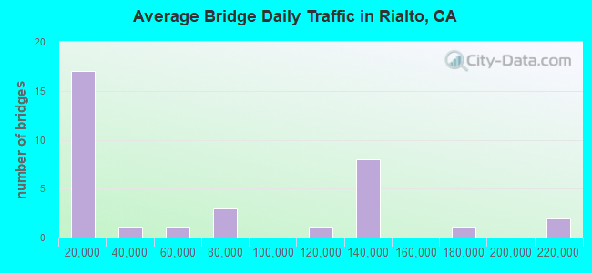
- 1,997,232Total average daily traffic
- 110,805Total average daily truck traffic
- National Bridge Inventory (NBI) Registered Bridges for Rialto
- No street view available for this location
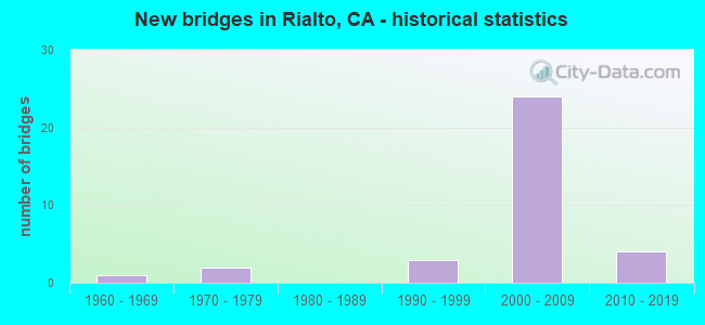
- New bridges - historical statistics
- 11960-1969
- 21970-1979
- 31990-1999
- 242000-2009
- 42010-2019
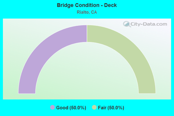
- Bridge Condition - Deck
- 50.0%Good
- 50.0%Fair
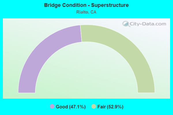
- Bridge Condition - Superstructure
- 47.1%Good
- 52.9%Fair
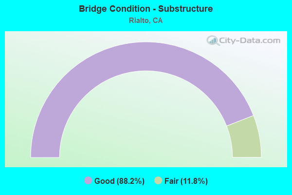
- Bridge Condition - Substructure
- 88.2%Good
- 11.8%Fair
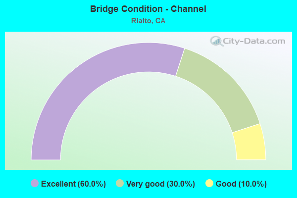
- Bridge Condition - Channel
- 60.0%Excellent
- 30.0%Very good
- 10.0%Good
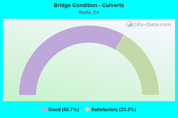
- Bridge Condition - Culverts
- 66.7%Good
- 33.3%Satisfactory
Find on map >> Show street view
Structure Number: 54 0622, Location: 08-SBD-210-17.94-RIA (Lat: 34.136150, Lng: -117.383708), Route carried "on" structure: City street , Year Built: 2006, Status: Open, Structure Length: 7.96m (26.12ft), Average Daily Traffic: 9,500 (year 2011), Truck Traffic: 2%, Average Future Daily Traffic: 10,800 (year 2040), Design Load: HS 20+Mod, Features Intersected: STATE ROUTE 210, Facility Carried by Structure: CACTUS AVENUE
Minimum Vertical Clearance: 30+ m (98+ ft), Kilometerpoint: 0.000, Lanes on structure: 4, Lanes under structure: 9, Owner: State Highway Agency, Approaching Roadway Width: 21.6m (70.9ft), Material/Design: Prestressed concrete continuous, Design/Construction: Box Beam or Girders - Multiple, Number Of Spans In Main Unit: 2, Length of Maximum Span: 40.7m (133.5ft), Curb or Sidewalk Widths: Left: 1.8m (5.9ft), Right: 1.8m (5.9ft), Curb-To-Curb Width: 21.6m (70.9ft), Out-to-Out Width: 25.8m (84.6ft)
Condition: Deck: Good, Superstructure: Fair, Substructure: Good, Operating Rating: 54.1 metric tons, Method Used To Determine Operating Rating: Assigned rating based on Load Factor Design (LFD) reported in metric tons, Inventory Rating: 32.4 metric tons, Method Used To Determine Inventory Rating: Assigned rating based on Load Factor Design (LFD) reported in metric tons, Structural Evaluation: Somewhat better than minimum adequacy, Deck Geometry: Superior to present desirable criteria, Underclear: Meets minimum limits, Approach Roadway Alignment: Equal to present desirable criteria, Designated Inspection Frequency: Every 24 months, Inspection Date: December 2020, Deck Structure Type: Concrete Cast-file-Place
Find on map >> Show street view
Structure Number: 54 0623, Location: 08-SBD-210-18.69-RIA (Lat: 34.136214, Lng: -117.370658), Route carried "on" structure: City street , Year Built: 2005, Status: Open, Structure Length: 7.17m (23.52ft), Average Daily Traffic: 15,500 (year 2014), Truck Traffic: 3%, Average Future Daily Traffic: 17,000 (year 2040), Design Load: HS 20+Mod, Features Intersected: STATE ROUTE 210, Facility Carried by Structure: RIVERSIDE AVENUE
Minimum Vertical Clearance: 30+ m (98+ ft), Kilometerpoint: 0.000, Lanes on structure: 8, Lanes under structure: 8, Base Highway Network: Yes, Owner: State Highway Agency, Approaching Roadway Width: 35.0m (114.8ft), Material/Design: Prestressed concrete continuous, Design/Construction: Box Beam or Girders - Multiple, Number Of Spans In Main Unit: 2, Length of Maximum Span: 35.8m (117.5ft), Curb or Sidewalk Widths: Left: 1.2m (3.9ft), Right: 1.2m (3.9ft), Curb-To-Curb Width: 34.8m (114.2ft), Out-to-Out Width: 40.5m (132.9ft)
Condition: Deck: Good, Superstructure: Fair, Substructure: Good, Operating Rating: 54.1 metric tons, Method Used To Determine Operating Rating: Assigned rating based on Load Factor Design (LFD) reported in metric tons, Inventory Rating: 32.4 metric tons, Method Used To Determine Inventory Rating: Assigned rating based on Load Factor Design (LFD) reported in metric tons, Structural Evaluation: Somewhat better than minimum adequacy, Deck Geometry: Better than present minimum criteria, Underclear: Meets minimum limits, Approach Roadway Alignment: Equal to present desirable criteria, Designated Inspection Frequency: Every 24 months, Inspection Date: December 2020, Deck Structure Type: Concrete Cast-file-Place
Find on map >> Show street view
Structure Number: 54 064, Location: 08-SBD-015-R103.63 (Lat: 35.011300, Lng: -116.531519), Route carried "on" structure: County highway , Year Built: 1963, Status: Open, Structure Length: 7.53m (24.70ft), Average Daily Traffic: 28 (year 2019), Truck Traffic: 2%, Average Future Daily Traffic: 46 (year 2041), Design Load: HS 20, Features Intersected: INTERSTATE 15, Facility Carried by Structure: FIELD ROAD
Minimum Vertical Clearance: 30+ m (98+ ft), Kilometerpoint: 0.000, Lanes on structure: 2, Lanes under structure: 4, Owner: State Highway Agency, Approaching Roadway Width: 8.7m (28.5ft), Skew: 1 degrees, Material/Design: Concrete continuous, Design/Construction: Box Beam or Girders - Multiple, Number Of Spans In Main Unit: 4, Length of Maximum Span: 26.8m (87.9ft), Curb or Sidewalk Widths: Left: 0.6m (2.0ft), Right: 0.6m (2.0ft), Curb-To-Curb Width: 8.5m (27.9ft), Out-to-Out Width: 10.4m (34.1ft)
Condition: Deck: Good, Superstructure: Good, Substructure: Fair, Operating Rating: 36.3 metric tons, Method Used To Determine Operating Rating: Load and Resistance Factor Rating (LRFR) rating reported by rating factor(RF) method using HL-93 loadings, Inventory Rating: 27.9 metric tons, Method Used To Determine Inventory Rating: Load and Resistance Factor Rating (LRFR) rating reported by rating factor(RF) method using HL-93 loadings, Structural Evaluation: Somewhat better than minimum adequacy, Deck Geometry: Better than present minimum criteria, Underclear: Meets minimum limits, Approach Roadway Alignment: Equal to present desirable criteria, Designated Inspection Frequency: Every 24 months, Inspection Date: September 2021, Deck Structure Type: Concrete Cast-file-Place, Wearing Surface/Protective System: Wearing Surface: Integral Concrete
Find on map >> Show street view
Structure Number: 54 0649, Location: 08-SBD-210-15.94-RIA (Lat: 34.136753, Lng: -117.418653), Route carried "on" structure: City street , Year Built: 2005, Status: Open, Structure Length: 7.26m (23.82ft), Average Daily Traffic: 3,001 (year 2021), Truck Traffic: 5%, Average Future Daily Traffic: 3,061 (year 2041), Design Load: HS 20+Mod, Features Intersected: STATE ROUTE 210, Facility Carried by Structure: ALDER AVENUE
Minimum Vertical Clearance: 30+ m (98+ ft), Kilometerpoint: 0.000, Lanes on structure: 4, Lanes under structure: 8, Owner: State Highway Agency, Approaching Roadway Width: 23.6m (77.4ft), Skew: 10 degrees, Material/Design: Prestressed concrete continuous, Design/Construction: Box Beam or Girders - Multiple, Number Of Spans In Main Unit: 2, Length of Maximum Span: 37.5m (123.0ft), Curb or Sidewalk Widths: Left: 1.8m (5.9ft), Right: 1.8m (5.9ft), Curb-To-Curb Width: 23.6m (77.4ft), Out-to-Out Width: 27.8m (91.2ft)
Condition: Deck: Fair, Superstructure: Fair, Substructure: Good, Operating Rating: 54.1 metric tons, Method Used To Determine Operating Rating: Assigned rating based on Load Factor Design (LFD) reported in metric tons, Inventory Rating: 32.4 metric tons, Method Used To Determine Inventory Rating: Assigned rating based on Load Factor Design (LFD) reported in metric tons, Structural Evaluation: Somewhat better than minimum adequacy, Deck Geometry: Superior to present desirable criteria, Underclear: Somewhat better than minimum adequacy, Approach Roadway Alignment: Equal to present desirable criteria, Designated Inspection Frequency: Every 24 months, Inspection Date: Febuary 2021, Deck Structure Type: Concrete Cast-file-Place
Find on map >> Show street view
Structure Number: 54 065, Location: 08-SBD-210-14.93-FNA (Lat: 34.136733, Lng: -117.436250), Route carried "on" structure: City street , Year Built: 2001, Status: Open, Structure Length: 8.35m (27.40ft), Average Daily Traffic: 9,500 (year 2015), Truck Traffic: 7%, Average Future Daily Traffic: 12,752 (year 2041), Design Load: HS 20+Mod, Features Intersected: STATE ROUTE 210, Facility Carried by Structure: SIERRA AVENUE
Minimum Vertical Clearance: 30+ m (98+ ft), Kilometerpoint: 0.000, Lanes on structure: 7, Lanes under structure: 10, Base Highway Network: Yes, Owner: State Highway Agency, Approaching Roadway Width: 45.3m (148.6ft), Material/Design: Prestressed concrete continuous, Design/Construction: Box Beam or Girders - Multiple, Number Of Spans In Main Unit: 2, Length of Maximum Span: 42.5m (139.4ft), Curb or Sidewalk Widths: Left: 1.8m (5.9ft), Right: 0.0m, Curb-To-Curb Width: 45.3m (148.6ft), Out-to-Out Width: 47.9m (157.2ft)
Condition: Deck: Fair, Superstructure: Fair, Substructure: Good, Operating Rating: 54.1 metric tons, Method Used To Determine Operating Rating: Assigned rating based on Load Factor Design (LFD) reported in metric tons, Inventory Rating: 32.4 metric tons, Method Used To Determine Inventory Rating: Assigned rating based on Load Factor Design (LFD) reported in metric tons, Structural Evaluation: Somewhat better than minimum adequacy, Deck Geometry: Superior to present desirable criteria, Underclear: Better than present minimum criteria, Approach Roadway Alignment: Equal to present desirable criteria, Designated Inspection Frequency: Every 24 months, Inspection Date: Febuary 2021, Deck Structure Type: Concrete Cast-file-Place
Find on map >> Show street view
Structure Number: 54 0651, Location: 08-SBD-210-16.44-RIA (Lat: 34.136636, Lng: -117.409886), Route carried "on" structure: City street , Year Built: 2005, Status: Open, Structure Length: 7.32m (24.02ft), Average Daily Traffic: 4,000 (year 2021), Truck Traffic: 5%, Average Future Daily Traffic: 5,203 (year 2041), Design Load: HS 20+Mod, Features Intersected: STATE ROUTE 210, Facility Carried by Structure: LOCUST AVENUE
Minimum Vertical Clearance: 30+ m (98+ ft), Kilometerpoint: 0.000, Lanes on structure: 4, Lanes under structure: 8, Owner: State Highway Agency, Approaching Roadway Width: 19.2m (63.0ft), Skew: 10 degrees, Material/Design: Prestressed concrete continuous, Design/Construction: Box Beam or Girders - Multiple, Number Of Spans In Main Unit: 2, Length of Maximum Span: 38.0m (124.7ft), Curb or Sidewalk Widths: Left: 1.8m (5.9ft), Right: 1.8m (5.9ft), Curb-To-Curb Width: 19.2m (63.0ft), Out-to-Out Width: 23.4m (76.8ft)
Condition: Deck: Fair, Superstructure: Fair, Substructure: Good, Operating Rating: 54.1 metric tons, Method Used To Determine Operating Rating: Assigned rating based on Load Factor Design (LFD) reported in metric tons, Inventory Rating: 32.4 metric tons, Method Used To Determine Inventory Rating: Assigned rating based on Load Factor Design (LFD) reported in metric tons, Structural Evaluation: Somewhat better than minimum adequacy, Deck Geometry: Equal to present minimum criteria, Underclear: Somewhat better than minimum adequacy, Approach Roadway Alignment: Equal to present desirable criteria, Designated Inspection Frequency: Every 24 months, Inspection Date: Febuary 2021, Deck Structure Type: Concrete Cast-file-Place
Find on map >> Show street view
Structure Number: 54 0652, Location: 08-SBD-210-16.94-RIA (Lat: 34.136419, Lng: -117.401169), Route carried "on" structure: City street , Year Built: 2005, Status: Open, Structure Length: 7.35m (24.11ft), Average Daily Traffic: 6,000 (year 2021), Truck Traffic: 5%, Average Future Daily Traffic: 7,855 (year 2041), Design Load: HS 20+Mod, Features Intersected: STATE ROUTE 210, Facility Carried by Structure: LINDEN AVENUE
Minimum Vertical Clearance: 30+ m (98+ ft), Kilometerpoint: 0.000, Lanes on structure: 5, Lanes under structure: 8, Owner: State Highway Agency, Approaching Roadway Width: 23.6m (77.4ft), Skew: 10 degrees, Material/Design: Prestressed concrete continuous, Design/Construction: Box Beam or Girders - Multiple, Number Of Spans In Main Unit: 2, Length of Maximum Span: 38.3m (125.7ft), Curb or Sidewalk Widths: Left: 1.8m (5.9ft), Right: 1.8m (5.9ft), Curb-To-Curb Width: 23.6m (77.4ft), Out-to-Out Width: 27.8m (91.2ft)
Condition: Deck: Fair, Superstructure: Fair, Substructure: Good, Operating Rating: 54.1 metric tons, Method Used To Determine Operating Rating: Assigned rating based on Load Factor Design (LFD) reported in metric tons, Inventory Rating: 32.4 metric tons, Method Used To Determine Inventory Rating: Assigned rating based on Load Factor Design (LFD) reported in metric tons, Structural Evaluation: Somewhat better than minimum adequacy, Deck Geometry: Better than present minimum criteria, Underclear: Somewhat better than minimum adequacy, Approach Roadway Alignment: Equal to present desirable criteria, Designated Inspection Frequency: Every 24 months, Inspection Date: Febuary 2021, Deck Structure Type: Concrete Cast-file-Place
Find on map >> Show street view
Structure Number: 54 0982L, Location: 08-SBD-015-13.08 (Lat: 34.184103, Lng: -117.434258), Route carried "on" structure: Interstate 15, Year Built: 1975, Status: Open, Structure Length: 60.38m (198.10ft), Average Daily Traffic: 63,500 (year 2017), Truck Traffic: 11%, Average Future Daily Traffic: 96,000 (year 2040), Design Load: HS 20, Features Intersected: LYTLE CREEK
Minimum Vertical Clearance: 30+ m (98+ ft), Kilometerpoint: 13.080, Lanes on structure: 4, Lanes under structure: 4, Base Highway Network: Yes (, Subroute: 1), Owner: State Highway Agency, Approaching Roadway Width: 20.2m (66.3ft), Material/Design: Concrete continuous, Design/Construction: Box Beam or Girders - Multiple, Number Of Spans In Main Unit: 18, Length of Maximum Span: 34.1m (111.9ft), Curb-To-Curb Width: 20.2m (66.3ft), Out-to-Out Width: 21.0m (68.9ft)
Condition: Deck: Fair, Superstructure: Good, Substructure: Good, Channel: Very good, Operating Rating: 54.8 metric tons, Method Used To Determine Operating Rating: Load and Resistance Factor Rating (LRFR) rating reported by rating factor(RF) method using HL-93 loadings, Inventory Rating: 42.1 metric tons, Method Used To Determine Inventory Rating: Load and Resistance Factor Rating (LRFR) rating reported by rating factor(RF) method using HL-93 loadings, Structural Evaluation: Better than present minimum criteria, Deck Geometry: Equal to present minimum criteria, Underclear: Equal to present minimum criteria, Waterway Adequacy: Superior to present desirable criteria, Approach Roadway Alignment: Equal to present desirable criteria, Designated Inspection Frequency: Every 24 months, Inspection Date: January 2021, Deck Structure Type: Concrete Cast-file-Place
Find on map >> Show street view
Structure Number: 54 0982R, Location: 08-SBD-015-13.08 (Lat: 34.183844, Lng: -117.433936), Route carried "on" structure: Interstate 15, Year Built: 1975, Status: Open, Structure Length: 60.38m (198.10ft), Average Daily Traffic: 63,500 (year 2017), Truck Traffic: 11%, Average Future Daily Traffic: 93,000 (year 2040), Design Load: HS 20, Features Intersected: LYTLE CREEK
Minimum Vertical Clearance: 30+ m (98+ ft), Kilometerpoint: 13.080, Lanes on structure: 4, Lanes under structure: 4, Base Highway Network: Yes (, Subroute: 1), Owner: State Highway Agency, Approaching Roadway Width: 20.2m (66.3ft), Material/Design: Concrete continuous, Design/Construction: Box Beam or Girders - Multiple, Number Of Spans In Main Unit: 18, Length of Maximum Span: 34.1m (111.9ft), Curb-To-Curb Width: 20.2m (66.3ft), Out-to-Out Width: 21.0m (68.9ft)
Condition: Deck: Fair, Superstructure: Good, Substructure: Good, Channel: Very good, Operating Rating: 99.8 metric tons, Method Used To Determine Operating Rating: Load Factor (LF), Inventory Rating: 68.4 metric tons, Method Used To Determine Inventory Rating: Load Factor (LF), Structural Evaluation: Better than present minimum criteria, Deck Geometry: Equal to present minimum criteria, Underclear: Equal to present minimum criteria, Waterway Adequacy: Superior to present desirable criteria, Approach Roadway Alignment: Equal to present desirable criteria, Designated Inspection Frequency: Every 24 months, Inspection Date: January 2021, Deck Structure Type: Concrete Cast-file-Place
Find on map >> Show street view
Structure Number: 54 1116, Location: 08-SBD-010-19.90-RIA (Lat: 34.068597, Lng: -117.371869), Route carried "on" structure: Interstate 10, Year Built: 1994, Year Reconstructed: 2012, Status: Open, Structure Length: 0.91m (2.99ft), Average Daily Traffic: 203,000 (year 2018), Truck Traffic: 10%, Average Future Daily Traffic: 225,000 (year 2040), Features Intersected: RIALTO CHANNEL
Minimum Vertical Clearance: 30+ m (98+ ft), Kilometerpoint: 19.900, Lanes on structure: 14, Base Highway Network: Yes (, Subroute: 1), Owner: State Highway Agency, Approaching Roadway Width: 37.8m (124.0ft), Skew: 30 degrees, Material/Design: Concrete continuous, Design/Construction: Culvert, Number Of Spans In Main Unit: 2, Length of Maximum Span: 4.6m (15.1ft), Curb-To-Curb Width: 37.8m (124.0ft), Out-to-Out Width: 40.2m (131.9ft)
Condition: Channel: Excellent, Culverts: Satisfactory, Operating Rating: 54.1 metric tons, Method Used To Determine Operating Rating: Field evaluation and documented engineering judgment, Inventory Rating: 32.4 metric tons, Method Used To Determine Inventory Rating: Field evaluation and documented engineering judgment, Structural Evaluation: Equal to present minimum criteria, Deck Geometry: High priority of replacement, Waterway Adequacy: Superior to present desirable criteria, Approach Roadway Alignment: Superior to present desirable criteria, Designated Inspection Frequency: Every 24 months, Inspection Date: April 2020, Deck Structure Type: Concrete Cast-file-Place
Find on map >> Show street view
Structure Number: 54 115, Location: 08-SBD-210-4.08-RCUC (Lat: 34.135244, Lng: -117.625317), Route carried "on" structure: City street , Year Built: 1999, Status: Open, Structure Length: 7.56m (24.80ft), Average Daily Traffic: 8,200 (year 2020), Truck Traffic: 5%, Average Future Daily Traffic: 9,500 (year 2040), Design Load: HS 20+Mod, Features Intersected: STATE ROUTE 210, Facility Carried by Structure: SAPPHIRE STREET
Minimum Vertical Clearance: 30+ m (98+ ft), Kilometerpoint: 0.000, Lanes on structure: 2, Lanes under structure: 8, Owner: State Highway Agency, Approaching Roadway Width: 10.9m (35.8ft), Material/Design: Prestressed concrete continuous, Design/Construction: Box Beam or Girders - Multiple, Number Of Spans In Main Unit: 2, Length of Maximum Span: 40.9m (134.2ft), Curb or Sidewalk Widths: Left: 1.5m (4.9ft), Right: 1.5m (4.9ft), Curb-To-Curb Width: 10.9m (35.8ft), Out-to-Out Width: 16.8m (55.1ft)
Condition: Deck: Good, Superstructure: Fair, Substructure: Good, Operating Rating: 54.1 metric tons, Method Used To Determine Operating Rating: Assigned rating based on Load Factor Design (LFD) reported in metric tons, Inventory Rating: 32.4 metric tons, Method Used To Determine Inventory Rating: Assigned rating based on Load Factor Design (LFD) reported in metric tons, Structural Evaluation: Somewhat better than minimum adequacy, Deck Geometry: Meets minimum limits, Underclear: Meets minimum limits, Approach Roadway Alignment: Equal to present desirable criteria, Designated Inspection Frequency: Every 24 months, Inspection Date: July 2020, Deck Structure Type: Concrete Cast-file-Place
Find on map >> Show street view
Structure Number: 54 1159, Location: 08-SBD-210-18.86-RIA (Lat: 34.136558, Lng: -117.367303), Route carried "on" structure: City street , Year Built: 2006, Status: Open, Structure Length: 13.59m (44.59ft), Average Daily Traffic: 29,000 (year 2014), Truck Traffic: 15%, Average Future Daily Traffic: 35,825 (year 2042), Design Load: HS 20+Mod, Features Intersected: STATE ROUTE 210 & RAMPS, Facility Carried by Structure: HIGHLAND AVENUE
Minimum Vertical Clearance: 30+ m (98+ ft), Kilometerpoint: 0.000, Lanes on structure: 4, Lanes under structure: 12, Base Highway Network: Yes, Owner: State Highway Agency, Approaching Roadway Width: 20.6m (67.6ft), Skew: 3 degrees, Material/Design: Prestressed concrete continuous, Design/Construction: Box Beam or Girders - Multiple, Number Of Spans In Main Unit: 4, Length of Maximum Span: 35.3m (115.8ft), Curb or Sidewalk Widths: Left: 1.5m (4.9ft), Right: 1.5m (4.9ft), Curb-To-Curb Width: 20.6m (67.6ft), Out-to-Out Width: 24.2m (79.4ft)
Condition: Deck: Good, Superstructure: Good, Substructure: Fair, Operating Rating: 54.1 metric tons, Method Used To Determine Operating Rating: Assigned rating based on Load Factor Design (LFD) reported in metric tons, Inventory Rating: 32.4 metric tons, Method Used To Determine Inventory Rating: Assigned rating based on Load Factor Design (LFD) reported in metric tons, Structural Evaluation: Somewhat better than minimum adequacy, Deck Geometry: Superior to present desirable criteria, Underclear: Somewhat better than minimum adequacy, Approach Roadway Alignment: Equal to present desirable criteria, Designated Inspection Frequency: Every 24 months, Inspection Date: December 2020, Deck Structure Type: Concrete Cast-file-Place
Find on map >> Show street view
Structure Number: 54 1160R, Location: 08-SBD-210-19.67-RIA (Lat: 34.134228, Lng: -117.353517), Route carried "on" structure: State highway 210, Year Built: 2007, Status: Open, Structure Length: 4.94m (16.21ft), Average Daily Traffic: 60,000 (year 2017), Truck Traffic: 3%, Average Future Daily Traffic: 75,000 (year 2040), Design Load: HS 20+Mod, Features Intersected: PEPPER AVENUE
Minimum Vertical Clearance: 30+ m (98+ ft), Kilometerpoint: 19.670, Lanes on structure: 4, Lanes under structure: 6, Base Highway Network: Yes, Owner: State Highway Agency, Approaching Roadway Width: 21.5m (70.5ft), Material/Design: Prestressed concrete, Design/Construction: Box Beam or Girders - Multiple, Number Of Spans In Main Unit: 1, Length of Maximum Span: 49.4m (162.1ft), Curb-To-Curb Width: 21.5m (70.5ft), Out-to-Out Width: 22.6m (74.1ft)
Condition: Deck: Good, Superstructure: Good, Substructure: Good, Operating Rating: 54.1 metric tons, Method Used To Determine Operating Rating: Assigned rating based on Load Factor Design (LFD) reported in metric tons, Inventory Rating: 32.4 metric tons, Method Used To Determine Inventory Rating: Assigned rating based on Load Factor Design (LFD) reported in metric tons, Structural Evaluation: Better than present minimum criteria, Deck Geometry: Better than present minimum criteria, Underclear: Superior to present desirable criteria, Approach Roadway Alignment: Equal to present desirable criteria, Designated Inspection Frequency: Every 24 months, Inspection Date: December 2020, Deck Structure Type: Concrete Cast-file-Place
Find on map >> Show street view
Structure Number: 54 1212, Location: 08-SBD-210-17.44-RIA (Lat: 34.136192, Lng: -117.392467), Route carried "on" structure: City street , Year Built: 2004, Status: Open, Structure Length: 7.30m (23.95ft), Average Daily Traffic: 7,000 (year 2016), Truck Traffic: 4%, Average Future Daily Traffic: 8,500 (year 2040), Design Load: HS 20+Mod, Features Intersected: STATE ROUTE 210, Facility Carried by Structure: AYALA DRIVE
Minimum Vertical Clearance: 30+ m (98+ ft), Kilometerpoint: 0.000, Lanes on structure: 7, Lanes under structure: 8, Owner: State Highway Agency, Approaching Roadway Width: 30.0m (98.4ft), Material/Design: Prestressed concrete continuous, Design/Construction: Box Beam or Girders - Multiple, Number Of Spans In Main Unit: 2, Length of Maximum Span: 37.5m (123.0ft), Curb or Sidewalk Widths: Left: 1.8m (5.9ft), Right: 1.8m (5.9ft), Curb-To-Curb Width: 30.0m (98.4ft), Out-to-Out Width: 34.2m (112.2ft)
Condition: Deck: Fair, Superstructure: Fair, Substructure: Good, Operating Rating: 54.1 metric tons, Method Used To Determine Operating Rating: Assigned rating based on Load Factor Design (LFD) reported in metric tons, Inventory Rating: 32.4 metric tons, Method Used To Determine Inventory Rating: Assigned rating based on Load Factor Design (LFD) reported in metric tons, Structural Evaluation: Somewhat better than minimum adequacy, Deck Geometry: Equal to present minimum criteria, Underclear: Meets minimum limits, Approach Roadway Alignment: Equal to present desirable criteria, Designated Inspection Frequency: Every 24 months, Inspection Date: December 2020, Deck Structure Type: Concrete Cast-file-Place
Find on map >> Show street view
Structure Number: 54 126, Location: 08-SBD-215-6.92-SBD (Lat: 34.104400, Lng: -117.301717), Route carried "on" structure: Interstate 215, Year Built: 2013, Status: Open, Structure Length: 4.14m (13.58ft), Average Daily Traffic: 177,000 (year 2019), Truck Traffic: 5%, Average Future Daily Traffic: 185,000 (year 2040), Design Load: HS 20+Mod, Features Intersected: THIRD STREET
Minimum Vertical Clearance: 30+ m (98+ ft), Kilometerpoint: 6.920, Lanes on structure: 13, Lanes under structure: 6, Base Highway Network: Yes, Owner: State Highway Agency, Approaching Roadway Width: 64.4m (211.3ft), Skew: 30 degrees, Material/Design: Concrete, Design/Construction: Box Beam or Girders - Multiple, Number Of Spans In Main Unit: 1, Length of Maximum Span: 41.4m (135.8ft), Curb-To-Curb Width: 64.4m (211.3ft), Out-to-Out Width: 66.0m (216.5ft)
Condition: Deck: Good, Superstructure: Good, Substructure: Good, Operating Rating: 54.1 metric tons, Method Used To Determine Operating Rating: Assigned rating based on Load Factor Design (LFD) reported in metric tons, Inventory Rating: 32.4 metric tons, Method Used To Determine Inventory Rating: Assigned rating based on Load Factor Design (LFD) reported in metric tons, Structural Evaluation: Better than present minimum criteria, Deck Geometry: Superior to present desirable criteria, Underclear: Somewhat better than minimum adequacy, Approach Roadway Alignment: Equal to present desirable criteria, Designated Inspection Frequency: Every 24 months, Inspection Date: Febuary 2022, Deck Structure Type: Concrete Cast-file-Place
Find on map >> Show street view
Structure Number: 54 1264, Location: 08-SBD-210-17.68-RIA (Lat: 34.135556, Lng: -117.388156), Route carried "on" structure: State highway 210, Year Built: 2005, Status: Open, Structure Length: 0.88m (2.89ft), Average Daily Traffic: 120,000 (year 2017), Truck Traffic: 3%, Average Future Daily Traffic: 125,000 (year 2040), Design Load: HS 20+Mod, Features Intersected: CACTUS CHANNEL
Minimum Vertical Clearance: 30+ m (98+ ft), Kilometerpoint: 17.680, Lanes on structure: 10, Base Highway Network: Yes (Inventory Route: 2, Subroute: 1), Owner: State Highway Agency, Approaching Roadway Width: 46.8m (153.5ft), Skew: 30 degrees, Material/Design: Concrete continuous, Design/Construction: Culvert, Number Of Spans In Main Unit: 2, Length of Maximum Span: 4.3m (14.1ft)
Condition: Channel: Excellent, Culverts: Good, Operating Rating: 54.1 metric tons, Method Used To Determine Operating Rating: Field evaluation and documented engineering judgment, Inventory Rating: 32.4 metric tons, Method Used To Determine Inventory Rating: Field evaluation and documented engineering judgment, Structural Evaluation: Better than present minimum criteria, Waterway Adequacy: Superior to present desirable criteria, Approach Roadway Alignment: Equal to present desirable criteria, Designated Inspection Frequency: Every 48 months, Inspection Date: December 2020
Find on map >> Show street view
Structure Number: 54 1267, Location: 08-SBD-010-19.97-RIA (Lat: 34.069211, Lng: -117.370506), Route carried "on" structure: City street , Year Built: 2011, Status: Open, Structure Length: 5.68m (18.64ft), Average Daily Traffic: 40,000 (year 2019), Truck Traffic: 10%, Average Future Daily Traffic: 50,000 (year 2041), Design Load: HS 20+Mod, Features Intersected: INTERSTATE 10, Facility Carried by Structure: RIVERSIDE AVENUE
Minimum Vertical Clearance: 30+ m (98+ ft), Kilometerpoint: 0.000, Lanes on structure: 9, Lanes under structure: 8, Owner: State Highway Agency, Approaching Roadway Width: 37.1m (121.7ft), Skew: 10 degrees, Material/Design: Prestressed concrete continuous, Design/Construction: Stringer/Multi-beam, Number Of Spans In Main Unit: 2, Length of Maximum Span: 28.4m (93.2ft), Curb or Sidewalk Widths: Left: 1.5m (4.9ft), Right: 1.5m (4.9ft), Curb-To-Curb Width: 37.4m (122.7ft), Out-to-Out Width: 41.1m (134.8ft)
Condition: Deck: Fair, Superstructure: Good, Substructure: Good, Operating Rating: 54.1 metric tons, Method Used To Determine Operating Rating: Assigned rating based on Load Factor Design (LFD) reported in metric tons, Inventory Rating: 32.4 metric tons, Method Used To Determine Inventory Rating: Assigned rating based on Load Factor Design (LFD) reported in metric tons, Structural Evaluation: Better than present minimum criteria, Deck Geometry: Equal to present minimum criteria, Underclear: High priority of corrective action, Approach Roadway Alignment: Equal to present desirable criteria, Designated Inspection Frequency: Every 24 months, Inspection Date: April 2020, Deck Structure Type: Concrete Cast-file-Place
Find on map >> Show street view
Structure Number: 54 1311G, Location: 08-SBD-015-16.07 (Lat: 34.220472, Lng: -117.409706), Route carried "on" structure: Ramp Interstate 15, Year Built: 2016, Status: Open, Structure Length: 16.09m (52.79ft), Average Daily Traffic: 1,001 (year 2016), Truck Traffic: 14%, Average Future Daily Traffic: 2,002 (year 2040), Design Load: HL 93, Features Intersected: CAJON CREEK / CAJON BLVD
Minimum Vertical Clearance: 6.24m (20.47ft), Kilometerpoint: 16.070, Lanes on structure: 2, Lanes under structure: 2, Base Highway Network: Yes (, Subroute: 1), Toll: Toll bridge, Owner: State Highway Agency, Approaching Roadway Width: 11.9m (39.0ft), Skew: 1 degrees, Material/Design: Prestressed concrete continuous, Design/Construction: Stringer/Multi-beam, Number Of Spans In Main Unit: 6, Length of Maximum Span: 38.2m (125.3ft), Curb-To-Curb Width: 11.9m (39.0ft), Out-to-Out Width: 12.7m (41.7ft)
Condition: Deck: Good, Superstructure: Good, Substructure: Good, Channel: Very good, Operating Rating: 42.1 metric tons, Method Used To Determine Operating Rating: Assigned ratings based on Load and Resistance Factor Design (LRFD) reported by rating factor (RF) using HL93 loadings, Inventory Rating: 32.4 metric tons, Method Used To Determine Inventory Rating: Assigned ratings based on Load and Resistance Factor Design (LRFD) reported by rating factor (RF) using HL93 loadings, Structural Evaluation: Better than present minimum criteria, Deck Geometry: Superior to present desirable criteria, Underclear: Somewhat better than minimum adequacy, Waterway Adequacy: Superior to present desirable criteria, Approach Roadway Alignment: Equal to present desirable criteria, Designated Inspection Frequency: Every 24 months, Inspection Date: January 2021, Deck Structure Type: Concrete Cast-file-Place, Wearing Surface/Protective System: Deck Protection: Epoxy Coated Reinforcing
Find on map >> Show street view
Structure Number: 54 1317, Location: 08-SBD-000--RIA (Lat: 34.136750, Lng: -117.418661), Route carried "on" structure: City street , Year Built: 2005, Status: Open, Structure Length: 0.64m (2.10ft), Average Daily Traffic: 8,000 (year 2013), Truck Traffic: 1%, Average Future Daily Traffic: 18,000 (year 2035), Features Intersected: CACTUS CHANNEL, Facility Carried by Structure: ALDER AVENUE
Minimum Vertical Clearance: 30+ m (98+ ft), Kilometerpoint: 0.000, Lanes on structure: 4, Owner: State Highway Agency, Approaching Roadway Width: 23.5m (77.1ft), Material/Design: Concrete, Design/Construction: Culvert, Number Of Spans In Main Unit: 2, Length of Maximum Span: 3.1m (10.2ft), Curb or Sidewalk Widths: Left: 3.0m (9.8ft), Right: 3.0m (9.8ft), Curb-To-Curb Width: 23.5m (77.1ft), Out-to-Out Width: 30.2m (99.1ft)
Condition: Channel: Excellent, Culverts: Good, Operating Rating: 54.1 metric tons, Method Used To Determine Operating Rating: Field evaluation and documented engineering judgment, Inventory Rating: 32.4 metric tons, Method Used To Determine Inventory Rating: Field evaluation and documented engineering judgment, Structural Evaluation: Better than present minimum criteria, Deck Geometry: Superior to present desirable criteria, Waterway Adequacy: Superior to present desirable criteria, Approach Roadway Alignment: Equal to present desirable criteria, Designated Inspection Frequency: Every 48 months, Inspection Date: December 2018
Find on map >> Show street view
Structure Number: 54 1318, Location: 08-SBD-000--RIA (Lat: 34.136636, Lng: -117.409892), Route carried "on" structure: City street , Year Built: 2005, Status: Open, Structure Length: 0.88m (2.89ft), Average Daily Traffic: 8,000 (year 2013), Truck Traffic: 1%, Average Future Daily Traffic: 18,000 (year 2035), Features Intersected: CACTUS CHANNEL, Facility Carried by Structure: LOCUST AVENUE
Minimum Vertical Clearance: 30+ m (98+ ft), Kilometerpoint: 0.000, Lanes on structure: 4, Owner: State Highway Agency, Approaching Roadway Width: 19.2m (63.0ft), Material/Design: Concrete, Design/Construction: Culvert, Number Of Spans In Main Unit: 2, Length of Maximum Span: 4.6m (15.1ft), Curb or Sidewalk Widths: Left: 3.2m (10.5ft), Right: 3.2m (10.5ft), Curb-To-Curb Width: 19.2m (63.0ft), Out-to-Out Width: 26.2m (86.0ft)
Condition: Channel: Excellent, Culverts: Good, Operating Rating: 54.1 metric tons, Method Used To Determine Operating Rating: Field evaluation and documented engineering judgment, Inventory Rating: 32.4 metric tons, Method Used To Determine Inventory Rating: Field evaluation and documented engineering judgment, Structural Evaluation: Better than present minimum criteria, Deck Geometry: Equal to present minimum criteria, Waterway Adequacy: Superior to present desirable criteria, Approach Roadway Alignment: Equal to present desirable criteria, Designated Inspection Frequency: Every 48 months, Inspection Date: December 2018
Find on map >> Show street view
Structure Number: 54 1319, Location: 08-SBD-000--RIA (Lat: 34.136419, Lng: -117.401167), Route carried "on" structure: City street , Year Built: 2005, Status: Open, Structure Length: 0.88m (2.89ft), Average Daily Traffic: 8,000 (year 2013), Truck Traffic: 1%, Average Future Daily Traffic: 18,000 (year 2035), Features Intersected: CACTUS CHANNEL, Facility Carried by Structure: LINDEN AVENUE
Minimum Vertical Clearance: 30+ m (98+ ft), Kilometerpoint: 0.000, Lanes on structure: 4, Owner: State Highway Agency, Approaching Roadway Width: 23.3m (76.4ft), Material/Design: Concrete, Design/Construction: Culvert, Number Of Spans In Main Unit: 2, Length of Maximum Span: 4.6m (15.1ft), Curb or Sidewalk Widths: Left: 3.2m (10.5ft), Right: 3.0m (9.8ft), Curb-To-Curb Width: 23.3m (76.4ft), Out-to-Out Width: 30.2m (99.1ft)
Condition: Channel: Excellent, Culverts: Good, Operating Rating: 54.1 metric tons, Method Used To Determine Operating Rating: Field evaluation and documented engineering judgment, Inventory Rating: 32.4 metric tons, Method Used To Determine Inventory Rating: Field evaluation and documented engineering judgment, Structural Evaluation: Better than present minimum criteria, Deck Geometry: Superior to present desirable criteria, Waterway Adequacy: Superior to present desirable criteria, Approach Roadway Alignment: Equal to present desirable criteria, Designated Inspection Frequency: Every 48 months, Inspection Date: December 2018
Find on map >> Show street view
Structure Number: 54C0761, Location: 0.1 MI S RTE 210 (Lat: 34.134419, Lng: -117.388142), Route carried "on" structure: City street , Year Built: 1990, Status: Open, Structure Length: 0.95m (3.12ft), Average Daily Traffic: 500 (year 2013), Truck Traffic: 1%, Average Future Daily Traffic: 921 (year 2040), Features Intersected: CACTUS CHANNEL, Facility Carried by Structure: W RENAISSANCE PKWY
Minimum Vertical Clearance: 30+ m (98+ ft), Kilometerpoint: 0.120, Lanes on structure: 2, Owner: City or Municipal Highway Agency, Approaching Roadway Width: 12.8m (42.0ft), Material/Design: Concrete, Design/Construction: Culvert, Number Of Spans In Main Unit: 2, Length of Maximum Span: 4.3m (14.1ft), Curb-To-Curb Width: 12.8m (42.0ft), Out-to-Out Width: 19.6m (64.3ft)
Condition: Channel: Excellent, Culverts: Satisfactory, Operating Rating: 54.1 metric tons, Method Used To Determine Operating Rating: Field evaluation and documented engineering judgment, Inventory Rating: 32.4 metric tons, Method Used To Determine Inventory Rating: Field evaluation and documented engineering judgment, Structural Evaluation: Equal to present minimum criteria, Deck Geometry: Superior to present desirable criteria, Waterway Adequacy: Equal to present desirable criteria, Approach Roadway Alignment: Equal to present desirable criteria, Designated Inspection Frequency: Every 48 months, Inspection Date: October 2018
Find on map >> Show street view
Structure Number: 54C0779, Location: 0.3 MI NE LYTLE CREEK RD (Lat: 34.189486, Lng: -117.434219), Route carried "on" structure: County highway , Year Built: 2006, Status: Open, Structure Length: 1.22m (4.00ft), Average Daily Traffic: 2,000 (year 2018), Truck Traffic: 4%, Average Future Daily Traffic: 3,000 (year 2040), Features Intersected: LYTLE CREEK, Facility Carried by Structure: GLEN HELEN PARKWAY
Minimum Vertical Clearance: 30+ m (98+ ft), Kilometerpoint: 0.000, Lanes on structure: 2, Owner: County Highway Agency, Approaching Roadway Width: 30.0m (98.4ft), Material/Design: Concrete, Design/Construction: Arch - Deck, Number Of Spans In Main Unit: 1, Length of Maximum Span: 12.2m (40.0ft)
Condition: Superstructure: Fair, Substructure: Good, Channel: Good, Operating Rating: 54.1 metric tons, Method Used To Determine Operating Rating: Field evaluation and documented engineering judgment, Inventory Rating: 32.4 metric tons, Method Used To Determine Inventory Rating: Field evaluation and documented engineering judgment, Structural Evaluation: Somewhat better than minimum adequacy, Waterway Adequacy: Better than present minimum criteria, Approach Roadway Alignment: Equal to present desirable criteria, Designated Inspection Frequency: Every 24 months, Inspection Date: July 2021
Find on map >> Show street view
Structure Number: 54 0622, Location: 08-SBD-210-17.94-RIA (Lat: 34.136150, Lng: -117.383708), Route carried "under" structure: State highway 210, Year Built: 2006, Structure Length: 0. m, Average Daily Traffic: 120,000 (year 2017), Truck Traffic: 3%, Features Intersected: STATE ROUTE 210, Facility Carried by Structure: CACTUS AVENUE
Minimum Vertical Clearance: 5.21m (17.09ft), Kilometerpoint: 17.940, Lanes on structure: 4, Lanes under structure: 9, Material/Design: Prestressed concrete continuous, Design/Construction: Box Beam or Girders - Multiple, Length of Maximum Span: 40.7m (133.5ft)
Find on map >> Show street view
Structure Number: 54 0623, Location: 08-SBD-210-18.69-RIA (Lat: 34.136214, Lng: -117.370658), Route carried "under" structure: State highway 210, Year Built: 2005, Structure Length: 0. m, Average Daily Traffic: 120,000 (year 2017), Truck Traffic: 3%, Features Intersected: STATE ROUTE 210, Facility Carried by Structure: RIVERSIDE AVENUE
Minimum Vertical Clearance: 5.41m (17.75ft), Kilometerpoint: 18.690, Lanes on structure: 8, Lanes under structure: 8, Material/Design: Prestressed concrete continuous, Design/Construction: Box Beam or Girders - Multiple, Length of Maximum Span: 35.8m (117.5ft)
Find on map >> Show street view
Structure Number: 54 0649, Location: 08-SBD-210-15.94-RIA (Lat: 34.136753, Lng: -117.418653), Route carried "under" structure: State highway 210, Year Built: 2005, Structure Length: 0. m, Average Daily Traffic: 120,000 (year 2019), Truck Traffic: 3%, Features Intersected: STATE ROUTE 210, Facility Carried by Structure: ALDER AVENUE
Minimum Vertical Clearance: 5.21m (17.09ft), Kilometerpoint: 15.940, Lanes on structure: 4, Lanes under structure: 8, Material/Design: Prestressed concrete continuous, Design/Construction: Box Beam or Girders - Multiple, Length of Maximum Span: 37.5m (123.0ft)
Find on map >> Show street view
Structure Number: 54 0651, Location: 08-SBD-210-16.44-RIA (Lat: 34.136636, Lng: -117.409886), Route carried "under" structure: State highway 210, Year Built: 2005, Structure Length: 0. m, Average Daily Traffic: 120,000 (year 2019), Truck Traffic: 3%, Features Intersected: STATE ROUTE 210, Facility Carried by Structure: LOCUST AVENUE
Minimum Vertical Clearance: 5.33m (17.49ft), Kilometerpoint: 16.440, Lanes on structure: 4, Lanes under structure: 8, Material/Design: Prestressed concrete continuous, Design/Construction: Box Beam or Girders - Multiple, Length of Maximum Span: 38.0m (124.7ft)
Find on map >> Show street view
Structure Number: 54 0652, Location: 08-SBD-210-16.94-RIA (Lat: 34.136419, Lng: -117.401169), Route carried "under" structure: State highway 210, Year Built: 2005, Structure Length: 0. m, Average Daily Traffic: 120,000 (year 2019), Truck Traffic: 3%, Features Intersected: STATE ROUTE 210, Facility Carried by Structure: LINDEN AVENUE
Minimum Vertical Clearance: 5.33m (17.49ft), Kilometerpoint: 16.940, Lanes on structure: 5, Lanes under structure: 8, Material/Design: Prestressed concrete continuous, Design/Construction: Box Beam or Girders - Multiple, Length of Maximum Span: 38.3m (125.7ft)
Find on map >> Show street view
Structure Number: 54 1159, Location: 08-SBD-210-18.86-RIA (Lat: 34.136558, Lng: -117.367303), Route carried "under" structure: Ramp State highway 210, Year Built: 2006, Structure Length: 0. m, Average Daily Traffic: 1,001 (year 2020), Truck Traffic: 3%, Features Intersected: STATE ROUTE 210 & RAMPS, Facility Carried by Structure: HIGHLAND AVENUE
Minimum Vertical Clearance: 7.85m (25.75ft), Kilometerpoint: 18.860, Lanes on structure: 4, Lanes under structure: 2, Material/Design: Prestressed concrete continuous, Design/Construction: Box Beam or Girders - Multiple, Length of Maximum Span: 35.3m (115.8ft)
Find on map >> Show street view
Structure Number: 54 1159, Location: 08-SBD-210-18.86-RIA (Lat: 34.136558, Lng: -117.367303), Route carried "under" structure: Ramp State highway 210, Year Built: 2006, Structure Length: 0. m, Average Daily Traffic: 1,001 (year 2020), Truck Traffic: 3%, Features Intersected: STATE ROUTE 210 & RAMPS, Facility Carried by Structure: HIGHLAND AVENUE
Minimum Vertical Clearance: 5.18m (16.99ft), Kilometerpoint: 18.860, Lanes on structure: 4, Lanes under structure: 2, Material/Design: Prestressed concrete continuous, Design/Construction: Box Beam or Girders - Multiple, Length of Maximum Span: 35.3m (115.8ft)
Find on map >> Show street view
Structure Number: 54 1159, Location: 08-SBD-210-18.86-RIA (Lat: 34.136558, Lng: -117.367303), Route carried "under" structure: State highway 210, Year Built: 2006, Structure Length: 0. m, Average Daily Traffic: 120,000 (year 2017), Truck Traffic: 3%, Features Intersected: STATE ROUTE 210 & RAMPS, Facility Carried by Structure: HIGHLAND AVENUE
Minimum Vertical Clearance: 5.92m (19.42ft), Kilometerpoint: 18.860, Lanes on structure: 4, Lanes under structure: 8, Material/Design: Prestressed concrete continuous, Design/Construction: Box Beam or Girders - Multiple, Length of Maximum Span: 35.3m (115.8ft)
Find on map >> Show street view
Structure Number: 54 1212, Location: 08-SBD-210-17.44-RIA (Lat: 34.136192, Lng: -117.392467), Route carried "under" structure: State highway 210, Year Built: 2004, Structure Length: 0. m, Average Daily Traffic: 120,000 (year 2017), Truck Traffic: 3%, Features Intersected: STATE ROUTE 210, Facility Carried by Structure: AYALA DRIVE
Minimum Vertical Clearance: 5.36m (17.59ft), Kilometerpoint: 17.440, Lanes on structure: 7, Lanes under structure: 8, Material/Design: Prestressed concrete continuous, Design/Construction: Box Beam or Girders - Multiple, Length of Maximum Span: 37.5m (123.0ft)
Find on map >> Show street view
Structure Number: 54 1213, Location: 08-SBD-210-18.13-RIA (Lat: 34.136092, Lng: -117.379233), Route carried "under" structure: State highway 210, Year Built: 2007, Structure Length: 0. m, Average Daily Traffic: 107,000 (year 2014), Truck Traffic: 5%, Features Intersected: STATE ROUTE 210, Facility Carried by Structure: PEDESTRIAN WALKWAY
Minimum Vertical Clearance: 5.84m (19.16ft), Kilometerpoint: 18.130, Lanes under structure: 9, Material/Design: Prestressed concrete continuous, Design/Construction: Box Beam or Girders - Multiple, Length of Maximum Span: 37.7m (123.7ft)
Find on map >> Show street view
Structure Number: 54 1267, Location: 08-SBD-010-19.97-RIA (Lat: 34.069211, Lng: -117.370506), Route carried "under" structure: Interstate 10, Year Built: 2011, Structure Length: 0. m, Average Daily Traffic: 202,000 (year 2018), Truck Traffic: 10%, Features Intersected: INTERSTATE 10, Facility Carried by Structure: RIVERSIDE AVENUE
Minimum Vertical Clearance: 5.48m (17.98ft), Kilometerpoint: 19.970, Lanes on structure: 9, Lanes under structure: 8, Material/Design: Prestressed concrete continuous, Design/Construction: Stringer/Multi-beam, Length of Maximum Span: 28.4m (93.2ft)