Bridge Statistics for Reynoldsville, Pennsylvania (PA)
Condition, Traffic, Stress, Structural Evaluation, Project Costs
- National Bridge Inventory (NBI) Statistics
- 35Number of bridges
- 223ft / 68.3mTotal length
- $5,343,000Total costs
- 159,547Total average daily traffic
- 51,197Total average daily truck traffic
- National Bridge Inventory (NBI) Registered Bridges for Reynoldsville
- No street view available for this location
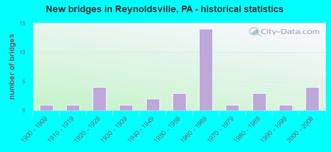
- New bridges - historical statistics
- 11900-1909
- 11910-1919
- 41920-1929
- 11930-1939
- 21940-1949
- 31950-1959
- 141960-1969
- 11970-1979
- 31980-1989
- 11990-1999
- 42000-2009

- Reconstructed bridges - Historical Statistics
- 11950-1959
- 01960-1969
- 11970-1979
- 01980-1989
- 41990-1999
- 32000-2009
- 42010-2019


- Bridge Condition - Deck
- 36.0%Good
- 44.0%Satisfactory
- 16.0%Fair
- 4.0%Poor

- Bridge Condition - Superstructure
- 7.7%Very good
- 26.9%Good
- 34.6%Satisfactory
- 26.9%Fair
- 3.8%Poor

- Bridge Condition - Substructure
- 30.8%Good
- 65.4%Satisfactory
- 3.8%Fair

- Bridge Condition - Channel
- 10.0%Very good
- 15.0%Good
- 60.0%Fair
- 15.0%Poor
Find on map >> Show street view
Structure Number: 1963, Location: 250'E.OF INTER.W/SR 4029 (Lat: 40.550794, Lng: -80.087253), Route carried "on" structure: State highway , Year Built: 1987, Status: Open, Structure Length: 1.31m (4.30ft), Average Daily Traffic: 6,989 (year 2022), Truck Traffic: 7%, Average Future Daily Traffic: 11,129 (year 2032), Design Load: HS 20, Features Intersected: BEAR RUN, Facility Carried by Structure: MOUNT NEBO RD
Minimum Vertical Clearance: 30+ m (98+ ft), Kilometerpoint: 2.445, Lanes on structure: 2, Owner: State Highway Agency, Approaching Roadway Width: 11.0m (36.1ft), Skew: 1 degrees, Material/Design: Concrete, Design/Construction: Culvert, Number Of Spans In Main Unit: 2, Length of Maximum Span: 6.7m (22.0ft)
Condition: Channel: Fair, Culverts: Satisfactory, Operating Rating: 88.0 metric tons, Method Used To Determine Operating Rating: Load Factor (LF), Inventory Rating: 52.6 metric tons, Method Used To Determine Inventory Rating: Load Factor (LF), Structural Evaluation: Equal to present minimum criteria, Waterway Adequacy: Equal to present minimum criteria, Approach Roadway Alignment: Equal to present desirable criteria, Length Of Structure Improvement: 2.10m (6.89ft), Designated Inspection Frequency: Every 24 months, Inspection Date: Febuary 2020
Find on map >> Show street view
Structure Number: 19585, Location: HORMTOWN NO.1 (Lat: 41.151844, Lng: -78.928892), Route carried "on" structure: Interstate 80, Year Built: 1964, Year Reconstructed: 1990, Status: Open, Structure Length: 3.63m (11.91ft), Average Daily Traffic: 14,934 (year 2021), Truck Traffic: 41%, Average Future Daily Traffic: 19,543 (year 2032), Design Load: HS 20+Mod, Features Intersected: SR1005
Minimum Vertical Clearance: 30+ m (98+ ft), Kilometerpoint: 25.856, Lanes on structure: 2, Lanes under structure: 2, Base Highway Network: Yes, Owner: State Highway Agency, Approaching Roadway Width: 11.6m (38.1ft), Skew: 14 degrees, Material/Design: Prestressed concrete, Design/Construction: Box Beam or Girders - Single/Spread, Number Of Spans In Main Unit: 3, Length of Maximum Span: 13.1m (43.0ft), Curb or Sidewalk Widths: Left: 0.5m (1.6ft), Right: 0.5m (1.6ft), Curb-To-Curb Width: 12.8m (42.0ft), Out-to-Out Width: 13.9m (45.6ft)
Condition: Deck: Satisfactory, Superstructure: Satisfactory, Substructure: Satisfactory, Operating Rating: 81.6 metric tons, Method Used To Determine Operating Rating: Load Factor (LF), Inventory Rating: 34.5 metric tons, Method Used To Determine Inventory Rating: Load Factor (LF), Structural Evaluation: Equal to present minimum criteria, Deck Geometry: Equal to present desirable criteria, Underclear: Meets minimum limits, Approach Roadway Alignment: Equal to present desirable criteria, Length Of Structure Improvement: 4.50m (14.76ft), Designated Inspection Frequency: Every 24 months, Inspection Date: August 2020, Deck Structure Type: Concrete Cast-file-Place, Wearing Surface/Protective System: Wearing Surface: Epoxy Overlay, Membrane: Epoxy, Deck Protection: Epoxy Coated Reinforcing
Find on map >> Show street view
Structure Number: 19587, Location: HORMTOWN NO.2 (Lat: 41.152181, Lng: -78.929564), Route carried "on" structure: Interstate 80, Year Built: 1964, Year Reconstructed: 1990, Status: Open, Structure Length: 3.60m (11.81ft), Average Daily Traffic: 14,850 (year 2021), Truck Traffic: 41%, Average Future Daily Traffic: 17,882 (year 2032), Design Load: HS 20+Mod, Features Intersected: SR1005
Minimum Vertical Clearance: 30+ m (98+ ft), Kilometerpoint: 25.544, Lanes on structure: 2, Lanes under structure: 2, Base Highway Network: Yes, Owner: State Highway Agency, Approaching Roadway Width: 11.6m (38.1ft), Skew: 14 degrees, Material/Design: Prestressed concrete, Design/Construction: Box Beam or Girders - Single/Spread, Number Of Spans In Main Unit: 3, Length of Maximum Span: 12.8m (42.0ft), Curb or Sidewalk Widths: Left: 0.5m (1.6ft), Right: 0.5m (1.6ft), Curb-To-Curb Width: 12.8m (42.0ft), Out-to-Out Width: 14.0m (45.9ft)
Condition: Deck: Satisfactory, Superstructure: Satisfactory, Substructure: Satisfactory, Operating Rating: 82.6 metric tons, Method Used To Determine Operating Rating: Load Factor (LF), Inventory Rating: 37.2 metric tons, Method Used To Determine Inventory Rating: Load Factor (LF), Structural Evaluation: Equal to present minimum criteria, Deck Geometry: Equal to present desirable criteria, Underclear: Meets minimum limits, Approach Roadway Alignment: Equal to present desirable criteria, Length Of Structure Improvement: 4.50m (14.76ft), Designated Inspection Frequency: Every 24 months, Inspection Date: August 2020, Bridge Improvement Cost: $10,000, Roadway Improvement Cost: $31,000, Total Project Cost: $140,000, Deck Structure Type: Concrete Cast-file-Place, Wearing Surface/Protective System: Wearing Surface: Epoxy Overlay, Membrane: Epoxy, Deck Protection: Epoxy Coated Reinforcing
Find on map >> Show street view
Structure Number: 19588, Location: MOORE ROAD EB (Lat: 41.152103, Lng: -78.910489), Route carried "on" structure: Interstate 80, Year Built: 1964, Status: Open, Structure Length: 1.92m (6.30ft), Average Daily Traffic: 14,934 (year 2021), Truck Traffic: 41%, Average Future Daily Traffic: 19,543 (year 2032), Design Load: HS 20+Mod, Features Intersected: T-450 MOORE ROAD
Minimum Vertical Clearance: 30+ m (98+ ft), Kilometerpoint: 27.599, Lanes on structure: 2, Lanes under structure: 2, Base Highway Network: Yes, Owner: State Highway Agency, Approaching Roadway Width: 11.6m (38.1ft), Skew: 10 degrees, Material/Design: Prestressed concrete, Design/Construction: Box Beam or Girders - Single/Spread, Number Of Spans In Main Unit: 1, Length of Maximum Span: 18.9m (62.0ft), Curb or Sidewalk Widths: Left: 0.2m (0.7ft), Right: 0.2m (0.7ft), Curb-To-Curb Width: 12.8m (42.0ft), Out-to-Out Width: 13.9m (45.6ft)
Condition: Deck: Satisfactory, Superstructure: Satisfactory, Substructure: Satisfactory, Operating Rating: 81.6 metric tons, Method Used To Determine Operating Rating: Load Factor (LF), Inventory Rating: 36.3 metric tons, Method Used To Determine Inventory Rating: Load Factor (LF), Structural Evaluation: Equal to present minimum criteria, Deck Geometry: Equal to present desirable criteria, Underclear: Meets minimum limits, Approach Roadway Alignment: Equal to present desirable criteria, Length Of Structure Improvement: 2.60m (8.53ft), Designated Inspection Frequency: Every 24 months, Inspection Date: July 2020, Deck Structure Type: Concrete Cast-file-Place, Wearing Surface/Protective System: Wearing Surface: Epoxy Overlay, Membrane: Epoxy, Deck Protection: Epoxy Coated Reinforcing
Find on map >> Show street view
Structure Number: 19589, Location: MOORE ROAD (Lat: 41.152556, Lng: -78.910272), Route carried "on" structure: Interstate 80, Year Built: 1964, Status: Open, Structure Length: 1.92m (6.30ft), Average Daily Traffic: 14,850 (year 2021), Truck Traffic: 41%, Average Future Daily Traffic: 17,882 (year 2032), Design Load: HS 20+Mod, Features Intersected: T-479 MOORE ROAD
Minimum Vertical Clearance: 30+ m (98+ ft), Kilometerpoint: 27.154, Lanes on structure: 2, Lanes under structure: 2, Base Highway Network: Yes, Owner: State Highway Agency, Approaching Roadway Width: 11.6m (38.1ft), Skew: 10 degrees, Material/Design: Prestressed concrete, Design/Construction: Box Beam or Girders - Single/Spread, Number Of Spans In Main Unit: 1, Length of Maximum Span: 18.9m (62.0ft), Curb or Sidewalk Widths: Left: 0.2m (0.7ft), Right: 0.2m (0.7ft), Curb-To-Curb Width: 12.8m (42.0ft), Out-to-Out Width: 13.9m (45.6ft)
Condition: Deck: Satisfactory, Superstructure: Satisfactory, Substructure: Satisfactory, Operating Rating: 81.6 metric tons, Method Used To Determine Operating Rating: Load Factor (LF), Inventory Rating: 36.3 metric tons, Method Used To Determine Inventory Rating: Load Factor (LF), Structural Evaluation: Equal to present minimum criteria, Deck Geometry: Equal to present desirable criteria, Underclear: High priority of corrective action, Approach Roadway Alignment: Equal to present desirable criteria, Length Of Structure Improvement: 2.60m (8.53ft), Designated Inspection Frequency: Every 24 months, Inspection Date: Febuary 2021, Deck Structure Type: Concrete Cast-file-Place, Wearing Surface/Protective System: Wearing Surface: Epoxy Overlay, Membrane: Epoxy, Deck Protection: Epoxy Coated Reinforcing
Find on map >> Show street view
Structure Number: 19629, Location: TROUT RUN NO.1 (Lat: 41.078717, Lng: -78.901728), Route carried "on" structure: State highway 310, Year Built: 1926, Year Reconstructed: 2010, Status: Open, Structure Length: 1.68m (5.51ft), Average Daily Traffic: 1,908 (year 2022), Truck Traffic: 8%, Average Future Daily Traffic: 2,611 (year 2032), Design Load: HL 93, Features Intersected: TROUT RUN
Minimum Vertical Clearance: 30+ m (98+ ft), Kilometerpoint: 16.736, Lanes on structure: 2, Base Highway Network: Yes, Owner: State Highway Agency, Approaching Roadway Width: 8.2m (26.9ft), Skew: 3 degrees, Material/Design: Prestressed concrete continuous, Design/Construction: Box Beam or Girders - Single/Spread, Number Of Spans In Main Unit: 2, Length of Maximum Span: 7.6m (24.9ft), Curb or Sidewalk Widths: Left: 0.5m (1.6ft), Right: 0.5m (1.6ft), Curb-To-Curb Width: 12.3m (40.4ft), Out-to-Out Width: 13.4m (44.0ft)
Condition: Deck: Satisfactory, Superstructure: Very good, Substructure: Good, Channel: Fair, Operating Rating: 94.3 metric tons, Method Used To Determine Operating Rating: Load Factor (LF), Inventory Rating: 58.1 metric tons, Method Used To Determine Inventory Rating: Load Factor (LF), Structural Evaluation: Better than present minimum criteria, Deck Geometry: Better than present minimum criteria, Waterway Adequacy: Equal to present minimum criteria, Approach Roadway Alignment: Equal to present desirable criteria, Length Of Structure Improvement: 1.70m (5.58ft), Designated Inspection Frequency: Every 48 months, Inspection Date: December 2018, Bridge Improvement Cost: $63,000, Roadway Improvement Cost: $186,000, Total Project Cost: $853,000, Deck Structure Type: Concrete Cast-file-Place, Wearing Surface/Protective System: Wearing Surface: Monolithic Concrete, Deck Protection: Epoxy Coated Reinforcing
Find on map >> Show street view
Structure Number: 1963, Location: REYNOLDSVILLE NO.2 (Lat: 41.089058, Lng: -78.886472), Route carried "on" structure: State highway 310, Year Built: 1940, Year Reconstructed: 2010, Status: Open, Structure Length: 1.80m (5.91ft), Average Daily Traffic: 1,908 (year 2022), Truck Traffic: 8%, Average Future Daily Traffic: 2,611 (year 2032), Design Load: HL 93, Features Intersected: SOLDIER RUN
Minimum Vertical Clearance: 30+ m (98+ ft), Kilometerpoint: 18.775, Lanes on structure: 2, Base Highway Network: Yes, Owner: State Highway Agency, Approaching Roadway Width: 7.6m (24.9ft), Material/Design: Prestressed concrete continuous, Design/Construction: Box Beam or Girders - Single/Spread, Number Of Spans In Main Unit: 2, Length of Maximum Span: 8.2m (26.9ft), Curb or Sidewalk Widths: Left: 0.2m (0.7ft), Right: 1.5m (4.9ft), Curb-To-Curb Width: 9.8m (32.2ft), Out-to-Out Width: 12.6m (41.3ft)
Condition: Deck: Satisfactory, Superstructure: Good, Substructure: Satisfactory, Channel: Fair, Operating Rating: 65.3 metric tons, Method Used To Determine Operating Rating: Load and Resistance Factor (LRFR), Inventory Rating: 49.9 metric tons, Method Used To Determine Inventory Rating: Load and Resistance Factor (LRFR), Structural Evaluation: Equal to present minimum criteria, Deck Geometry: Somewhat better than minimum adequacy, Waterway Adequacy: Equal to present minimum criteria, Approach Roadway Alignment: Equal to present desirable criteria, Length Of Structure Improvement: 2.50m (8.20ft), Designated Inspection Frequency: Every 24 months, Inspection Date: July 2020, Bridge Improvement Cost: $39,000, Roadway Improvement Cost: $116,000, Total Project Cost: $531,000, Deck Structure Type: Concrete Cast-file-Place, Wearing Surface/Protective System: Wearing Surface: Monolithic Concrete, Deck Protection: Epoxy Coated Reinforcing
Find on map >> Show street view
Structure Number: 19638, Location: REYNOLDSVILLE NO.1 (Lat: 41.099297, Lng: -78.891908), Route carried "on" structure: US 322, Year Built: 1913, Status: Open, Structure Length: 2.74m (8.99ft), Average Daily Traffic: 5,109 (year 2021), Truck Traffic: 6%, Average Future Daily Traffic: 7,655 (year 2032), Design Load: HS 20, Features Intersected: SANDY LICK CREEK
Minimum Vertical Clearance: 30+ m (98+ ft), Kilometerpoint: 30.367, Lanes on structure: 2, Base Highway Network: Yes, Owner: State Highway Agency, Approaching Roadway Width: 9.1m (29.9ft), Material/Design: Concrete, Design/Construction: Arch - Deck, Number Of Spans In Main Unit: 1, Length of Maximum Span: 27.4m (89.9ft), Curb or Sidewalk Widths: Left: 1.8m (5.9ft), Right: 1.8m (5.9ft), Curb-To-Curb Width: 9.1m (29.9ft), Out-to-Out Width: 13.7m (44.9ft)
Condition: Superstructure: Fair, Substructure: Satisfactory, Channel: Fair, Operating Rating: 49.0 metric tons, Method Used To Determine Operating Rating: Field evaluation and documented engineering judgment, Inventory Rating: 32.7 metric tons, Method Used To Determine Inventory Rating: Field evaluation and documented engineering judgment, Structural Evaluation: Somewhat better than minimum adequacy, Deck Geometry: High priority of corrective action, Waterway Adequacy: Equal to present desirable criteria, Approach Roadway Alignment: Equal to present minimum criteria, Length Of Structure Improvement: 3.60m (11.81ft), Designated Inspection Frequency: Every 24 months, Inspection Date: July 2020, Bridge Improvement Cost: $52,000, Roadway Improvement Cost: $152,000, Total Project Cost: $697,000, Deck Structure Type: Concrete Cast-file-Place
Find on map >> Show street view
Structure Number: 1964, Location: PRESCOTTVILLE NO.1 (Lat: 41.084792, Lng: -78.867136), Route carried "on" structure: US 322, Year Built: 1926, Year Reconstructed: 1957, Status: Open, Structure Length: 0.88m (2.89ft), Average Daily Traffic: 5,853 (year 2020), Truck Traffic: 6%, Average Future Daily Traffic: 6,691 (year 2032), Design Load: HS 20, Features Intersected: SOLDIER RUN
Minimum Vertical Clearance: 30+ m (98+ ft), Kilometerpoint: 33.273, Lanes on structure: 2, Base Highway Network: Yes, Owner: State Highway Agency, Approaching Roadway Width: 10.4m (34.1ft), Skew: 3 degrees, Material/Design: Prestressed concrete, Design/Construction: Box Beam or Girders - Single/Spread, Number Of Spans In Main Unit: 1, Length of Maximum Span: 7.9m (25.9ft), Curb or Sidewalk Widths: Left: 0.3m (1.0ft), Right: 0.3m (1.0ft), Curb-To-Curb Width: 11.8m (38.7ft), Out-to-Out Width: 12.6m (41.3ft)
Condition: Deck: Good, Superstructure: Good, Substructure: Satisfactory, Channel: Fair, Operating Rating: 72.6 metric tons, Method Used To Determine Operating Rating: Allowable Stress (AS), Inventory Rating: 45.4 metric tons, Method Used To Determine Inventory Rating: Allowable Stress (AS), Structural Evaluation: Equal to present minimum criteria, Deck Geometry: Somewhat better than minimum adequacy, Waterway Adequacy: Equal to present minimum criteria, Approach Roadway Alignment: Equal to present desirable criteria, Length Of Structure Improvement: 1.60m (5.25ft), Designated Inspection Frequency: Every 48 months, Inspection Date: January 2019, Bridge Improvement Cost: $53,000, Roadway Improvement Cost: $157,000, Total Project Cost: $719,000, Deck Structure Type: Concrete Cast-file-Place, Wearing Surface/Protective System: Wearing Surface: Monolithic Concrete, Deck Protection: Epoxy Coated Reinforcing
Find on map >> Show street view
Structure Number: 19642, Location: PRESCOTTVILLE NO.3 (Lat: 41.089975, Lng: -78.857914), Route carried "on" structure: US 322, Year Built: 1927, Year Reconstructed: 1998, Status: Open, Structure Length: 1.77m (5.81ft), Average Daily Traffic: 4,553 (year 2022), Truck Traffic: 4%, Average Future Daily Traffic: 5,235 (year 2032), Design Load: HS 20, Features Intersected: SOLDIER RUN
Minimum Vertical Clearance: 30+ m (98+ ft), Kilometerpoint: 33.885, Lanes on structure: 2, Base Highway Network: Yes, Owner: State Highway Agency, Approaching Roadway Width: 10.4m (34.1ft), Skew: 3 degrees, Material/Design: Prestressed concrete, Design/Construction: Box Beam or Girders - Single/Spread, Number Of Spans In Main Unit: 2, Length of Maximum Span: 7.9m (25.9ft), Curb or Sidewalk Widths: Left: 0.3m (1.0ft), Right: 0.3m (1.0ft), Curb-To-Curb Width: 11.9m (39.0ft), Out-to-Out Width: 12.6m (41.3ft)
Condition: Deck: Satisfactory, Superstructure: Good, Substructure: Satisfactory, Channel: Fair, Operating Rating: 68.0 metric tons, Method Used To Determine Operating Rating: Load Factor (LF), Inventory Rating: 40.8 metric tons, Method Used To Determine Inventory Rating: Load Factor (LF), Structural Evaluation: Equal to present minimum criteria, Deck Geometry: Somewhat better than minimum adequacy, Waterway Adequacy: Equal to present desirable criteria, Approach Roadway Alignment: Equal to present desirable criteria, Length Of Structure Improvement: 2.50m (8.20ft), Designated Inspection Frequency: Every 24 months, Inspection Date: July 2020, Deck Structure Type: Concrete Cast-file-Place, Wearing Surface/Protective System: Wearing Surface: Monolithic Concrete, Deck Protection: Epoxy Coated Reinforcing
Find on map >> Show street view
Structure Number: 19643, Location: PRESCOTTVILLE NO.4 (Lat: 41.092319, Lng: -78.853706), Route carried "on" structure: US 322, Year Built: 1957, Status: Open, Structure Length: 0.76m (2.49ft), Average Daily Traffic: 4,553 (year 2022), Truck Traffic: 4%, Average Future Daily Traffic: 5,235 (year 2032), Design Load: HS 20, Features Intersected: FEHLEY RUN
Minimum Vertical Clearance: 30+ m (98+ ft), Kilometerpoint: 34.717, Lanes on structure: 2, Base Highway Network: Yes, Owner: State Highway Agency, Approaching Roadway Width: 9.1m (29.9ft), Skew: 1 degrees, Material/Design: Concrete, Design/Construction: Tee Beam, Number Of Spans In Main Unit: 1, Length of Maximum Span: 6.7m (22.0ft), Curb or Sidewalk Widths: Left: 0.2m (0.7ft), Right: 0.2m (0.7ft), Curb-To-Curb Width: 11.5m (37.7ft), Out-to-Out Width: 12.6m (41.3ft)
Condition: Deck: Fair, Superstructure: Fair, Substructure: Satisfactory, Channel: Poor, Operating Rating: 78.9 metric tons, Method Used To Determine Operating Rating: Load Factor (LF), Inventory Rating: 47.2 metric tons, Method Used To Determine Inventory Rating: Load Factor (LF), Structural Evaluation: Somewhat better than minimum adequacy, Deck Geometry: Somewhat better than minimum adequacy, Waterway Adequacy: Equal to present minimum criteria, Approach Roadway Alignment: Equal to present desirable criteria, Length Of Structure Improvement: 1.50m (4.92ft), Designated Inspection Frequency: Every 24 months, Inspection Date: July 2020, Bridge Improvement Cost: $4,000, Roadway Improvement Cost: $13,000, Total Project Cost: $59,000, Deck Structure Type: Concrete Cast-file-Place, Wearing Surface/Protective System: Wearing Surface: Bituminous, Membrane: Preformed Fabric
Find on map >> Show street view
Structure Number: 19644, Location: RATHMEL NO.1 (Lat: 41.093744, Lng: -78.839900), Route carried "on" structure: US 322, Year Built: 1927, Year Reconstructed: 1997, Status: Open, Structure Length: 0.82m (2.69ft), Average Daily Traffic: 4,553 (year 2022), Truck Traffic: 4%, Average Future Daily Traffic: 5,235 (year 2032), Design Load: HS 20, Features Intersected: RATHMEL RUN
Minimum Vertical Clearance: 30+ m (98+ ft), Kilometerpoint: 35.364, Lanes on structure: 2, Base Highway Network: Yes, Owner: State Highway Agency, Approaching Roadway Width: 9.4m (30.8ft), Skew: 4 degrees, Material/Design: Prestressed concrete, Design/Construction: Box Beam or Girders - Single/Spread, Number Of Spans In Main Unit: 1, Length of Maximum Span: 7.3m (24.0ft), Curb or Sidewalk Widths: Left: 0.2m (0.7ft), Right: 0.2m (0.7ft), Curb-To-Curb Width: 11.6m (38.1ft), Out-to-Out Width: 12.6m (41.3ft)
Condition: Deck: Good, Superstructure: Good, Substructure: Satisfactory, Channel: Fair, Operating Rating: 68.0 metric tons, Method Used To Determine Operating Rating: Load Factor (LF), Inventory Rating: 40.8 metric tons, Method Used To Determine Inventory Rating: Load Factor (LF), Structural Evaluation: Equal to present minimum criteria, Deck Geometry: Somewhat better than minimum adequacy, Waterway Adequacy: Equal to present desirable criteria, Approach Roadway Alignment: Equal to present desirable criteria, Length Of Structure Improvement: 1.40m (4.59ft), Designated Inspection Frequency: Every 24 months, Inspection Date: July 2020, Bridge Improvement Cost: $3,000, Roadway Improvement Cost: $9,000, Total Project Cost: $41,000, Deck Structure Type: Concrete Cast-file-Place, Wearing Surface/Protective System: Wearing Surface: Monolithic Concrete, Deck Protection: Epoxy Coated Reinforcing
Find on map >> Show street view
Structure Number: 19682, Location: PARDUS NO.4 (Lat: 41.151258, Lng: -78.872519), Route carried "on" structure: State highway , Year Built: 1964, Status: Open, Structure Length: 8.63m (28.31ft), Average Daily Traffic: 311 (year 2022), Truck Traffic: 6%, Average Future Daily Traffic: 432 (year 2032), Design Load: HS 20, Features Intersected: SR0080 EB&WB, Facility Carried by Structure: SR 1009
Minimum Vertical Clearance: 30+ m (98+ ft), Kilometerpoint: 2.684, Lanes on structure: 2, Lanes under structure: 4, Owner: State Highway Agency, Approaching Roadway Width: 7.3m (24.0ft), Material/Design: Prestressed concrete, Design/Construction: Box Beam or Girders - Single/Spread, Number Of Spans In Main Unit: 6, Length of Maximum Span: 17.4m (57.1ft), Curb or Sidewalk Widths: Left: 0.5m (1.6ft), Right: 0.5m (1.6ft), Curb-To-Curb Width: 8.6m (28.2ft), Out-to-Out Width: 10.2m (33.5ft)
Condition: Deck: Fair, Superstructure: Fair, Substructure: Fair, Operating Rating: 42.6 metric tons, Method Used To Determine Operating Rating: Load Factor (LF), Inventory Rating: 25.4 metric tons, Method Used To Determine Inventory Rating: Load Factor (LF), Structural Evaluation: Somewhat better than minimum adequacy, Deck Geometry: Equal to present minimum criteria, Underclear: High priority of corrective action, Approach Roadway Alignment: Equal to present desirable criteria, Length Of Structure Improvement: 9.60m (31.50ft), Designated Inspection Frequency: Every 24 months, Inspection Date: September 2020, Deck Structure Type: Concrete Cast-file-Place, Wearing Surface/Protective System: Wearing Surface: Bituminous
Find on map >> Show street view
Structure Number: 19707, Location: PRESCOTTVILLE NO.5 (Lat: 41.083597, Lng: -78.868578), Route carried "on" structure: State highway , Year Built: 1962, Status: Open, Structure Length: 2.07m (6.79ft), Average Daily Traffic: 562 (year 2021), Truck Traffic: 5%, Average Future Daily Traffic: 735 (year 2032), Design Load: HS 20, Features Intersected: SOLDIER RUN, Facility Carried by Structure: SR2007
Minimum Vertical Clearance: 30+ m (98+ ft), Kilometerpoint: 18.647, Lanes on structure: 2, Owner: State Highway Agency, Approaching Roadway Width: 7.6m (24.9ft), Skew: 1 degrees, Material/Design: Prestressed concrete, Design/Construction: Box Beam or Girders - Single/Spread, Number Of Spans In Main Unit: 1, Length of Maximum Span: 20.4m (66.9ft), Curb or Sidewalk Widths: Left: 0.5m (1.6ft), Right: 0.5m (1.6ft), Curb-To-Curb Width: 8.6m (28.2ft), Out-to-Out Width: 10.2m (33.5ft)
Condition: Deck: Fair, Superstructure: Satisfactory, Substructure: Satisfactory, Channel: Fair, Operating Rating: 89.8 metric tons, Method Used To Determine Operating Rating: Load Factor (LF), Inventory Rating: 46.3 metric tons, Method Used To Determine Inventory Rating: Load Factor (LF), Structural Evaluation: Equal to present minimum criteria, Deck Geometry: Somewhat better than minimum adequacy, Waterway Adequacy: Equal to present desirable criteria, Approach Roadway Alignment: Equal to present desirable criteria, Length Of Structure Improvement: 2.70m (8.86ft), Designated Inspection Frequency: Every 24 months, Inspection Date: September 2020, Deck Structure Type: Concrete Cast-file-Place, Wearing Surface/Protective System: Wearing Surface: Bituminous
Find on map >> Show street view
Structure Number: 1971, Location: TROUT RUN NO.2 (Lat: 41.071467, Lng: -78.896994), Route carried "on" structure: State highway , Year Built: 1983, Status: Open, Structure Length: 0.70m (2.30ft), Average Daily Traffic: 127 (year 2020), Truck Traffic: 16%, Average Future Daily Traffic: 168 (year 2032), Design Load: HS 20, Features Intersected: TROUT RUN, Facility Carried by Structure: SR2010
Minimum Vertical Clearance: 30+ m (98+ ft), Kilometerpoint: 4.094, Lanes on structure: 2, Owner: State Highway Agency, Approaching Roadway Width: 5.8m (19.0ft), Material/Design: Concrete, Design/Construction: Slab, Number Of Spans In Main Unit: 1, Length of Maximum Span: 6.1m (20.0ft), Curb-To-Curb Width: 6.6m (21.7ft), Out-to-Out Width: 7.6m (24.9ft)
Condition: Deck: Fair, Superstructure: Fair, Substructure: Satisfactory, Channel: Poor, Operating Rating: 59.9 metric tons, Method Used To Determine Operating Rating: Load Factor (LF), Inventory Rating: 36.3 metric tons, Method Used To Determine Inventory Rating: Load Factor (LF), Structural Evaluation: Somewhat better than minimum adequacy, Deck Geometry: Meets minimum limits, Waterway Adequacy: Better than present minimum criteria, Approach Roadway Alignment: Equal to present minimum criteria, Length Of Structure Improvement: 1.30m (4.27ft), Designated Inspection Frequency: Every 24 months, Inspection Date: October 2020, Bridge Improvement Cost: $14,000, Roadway Improvement Cost: $40,000, Total Project Cost: $186,000, Deck Structure Type: Concrete Cast-file-Place, Wearing Surface/Protective System: Wearing Surface: Bituminous, Deck Protection: Epoxy Coated Reinforcing
Find on map >> Show street view
Structure Number: 19711, Location: TROUT RUN NO.3 (Lat: 41.058833, Lng: -78.883494), Route carried "on" structure: State highway , Year Built: 1961, Year Reconstructed: 2008, Status: Open, Structure Length: 1.31m (4.30ft), Average Daily Traffic: 127 (year 2020), Truck Traffic: 16%, Average Future Daily Traffic: 168 (year 2032), Design Load: HS 20, Features Intersected: TROUT RUN, Facility Carried by Structure: SR2010
Minimum Vertical Clearance: 30+ m (98+ ft), Kilometerpoint: 7.068, Lanes on structure: 2, Owner: State Highway Agency, Approaching Roadway Width: 6.1m (20.0ft), Skew: 2 degrees, Material/Design: Prestressed concrete, Design/Construction: Box Beam or Girders - Multiple, Number Of Spans In Main Unit: 1, Length of Maximum Span: 12.8m (42.0ft), Curb or Sidewalk Widths: Left: 0.5m (1.6ft), Right: 0.5m (1.6ft), Curb-To-Curb Width: 9.1m (29.9ft), Out-to-Out Width: 10.8m (35.4ft)
Condition: Deck: Good, Superstructure: Fair, Substructure: Satisfactory, Channel: Fair, Operating Rating: 52.6 metric tons, Method Used To Determine Operating Rating: Load Factor (LF), Inventory Rating: 16.3 metric tons, Method Used To Determine Inventory Rating: Load Factor (LF), Structural Evaluation: Somewhat better than minimum adequacy, Deck Geometry: Equal to present minimum criteria, Waterway Adequacy: Better than present minimum criteria, Approach Roadway Alignment: Equal to present desirable criteria, Length Of Structure Improvement: 2.00m (6.56ft), Designated Inspection Frequency: Every 24 months, Inspection Date: October 2020, Bridge Improvement Cost: $5,000, Roadway Improvement Cost: $18,000, Total Project Cost: $72,000, Deck Structure Type: Concrete Cast-file-Place, Wearing Surface/Protective System: Wearing Surface: Monolithic Concrete, Deck Protection: Epoxy Coated Reinforcing
Find on map >> Show street view
Structure Number: 19725, Location: FRONT RUN (Lat: 41.068233, Lng: -78.902992), Route carried "on" structure: State highway , Year Built: 1948, Status: Open, Structure Length: 0.64m (2.10ft), Average Daily Traffic: 197 (year 2022), Truck Traffic: 3%, Average Future Daily Traffic: 427 (year 2032), Design Load: H 20, Features Intersected: FRONT RUN, Facility Carried by Structure: SR2027
Minimum Vertical Clearance: 30+ m (98+ ft), Kilometerpoint: 3.029, Lanes on structure: 2, Owner: State Highway Agency, Approaching Roadway Width: 5.5m (18.0ft), Skew: 1 degrees, Material/Design: Concrete, Design/Construction: Slab, Number Of Spans In Main Unit: 1, Length of Maximum Span: 6.1m (20.0ft), Curb or Sidewalk Widths: Left: 0.2m (0.7ft), Right: 0.2m (0.7ft), Curb-To-Curb Width: 7.8m (25.6ft), Out-to-Out Width: 8.2m (26.9ft)
Condition: Deck: Satisfactory, Superstructure: Satisfactory, Substructure: Satisfactory, Channel: Fair, Operating Rating: 49.0 metric tons, Method Used To Determine Operating Rating: Load Factor (LF), Inventory Rating: 32.7 metric tons, Method Used To Determine Inventory Rating: Load Factor (LF), Structural Evaluation: Equal to present minimum criteria, Deck Geometry: Somewhat better than minimum adequacy, Waterway Adequacy: Equal to present desirable criteria, Approach Roadway Alignment: Equal to present desirable criteria, Length Of Structure Improvement: 1.20m (3.94ft), Designated Inspection Frequency: Every 24 months, Inspection Date: September 2020, Deck Structure Type: Concrete Cast-file-Place, Wearing Surface/Protective System: Wearing Surface: Monolithic Concrete, Deck Protection: Epoxy Coated Reinforcing
Find on map >> Show street view
Structure Number: 19728, Location: RATHMEL NO.2 (Lat: 41.093025, Lng: -78.839650), Route carried "on" structure: State highway , Year Built: 1957, Status: Open, Structure Length: 1.16m (3.81ft), Average Daily Traffic: 104 (year 2022), Truck Traffic: 6%, Average Future Daily Traffic: 181 (year 2032), Design Load: HS 20, Features Intersected: SOLDIER RUN, Facility Carried by Structure: SR2033
Minimum Vertical Clearance: 30+ m (98+ ft), Kilometerpoint: 1.036, Lanes on structure: 2, Owner: State Highway Agency, Approaching Roadway Width: 6.1m (20.0ft), Skew: 1 degrees, Material/Design: Prestressed concrete, Design/Construction: Box Beam or Girders - Multiple, Number Of Spans In Main Unit: 1, Length of Maximum Span: 11.0m (36.1ft), Curb or Sidewalk Widths: Left: 0.3m (1.0ft), Right: 0.3m (1.0ft), Curb-To-Curb Width: 8.6m (28.2ft), Out-to-Out Width: 9.1m (29.9ft)
Condition: Deck: Poor, Superstructure: Poor, Substructure: Satisfactory, Channel: Poor, Operating Rating: 59.9 metric tons, Method Used To Determine Operating Rating: Load Factor (LF), Inventory Rating: 29.0 metric tons, Method Used To Determine Inventory Rating: Load Factor (LF), Structural Evaluation: Meets minimum limits, Deck Geometry: Equal to present minimum criteria, Waterway Adequacy: Equal to present desirable criteria, Approach Roadway Alignment: Equal to present desirable criteria, Length Of Structure Improvement: 1.80m (5.91ft), Designated Inspection Frequency: Every 24 months, Inspection Date: October 2020, Bridge Improvement Cost: $4,000, Roadway Improvement Cost: $12,000, Total Project Cost: $54,000, Deck Structure Type: Other, Wearing Surface/Protective System: Wearing Surface: Bituminous
Find on map >> Show street view
Structure Number: 19729, Location: RATHMEL NO.3 (Lat: 41.093847, Lng: -78.839575), Route carried "on" structure: State highway , Year Built: 1908, Year Reconstructed: 1981, Status: Open, Structure Length: 0.64m (2.10ft), Average Daily Traffic: 476 (year 2022), Truck Traffic: 10%, Average Future Daily Traffic: 762 (year 2032), Design Load: HS 20, Features Intersected: RATHMEL RUN, Facility Carried by Structure: SR2033
Minimum Vertical Clearance: 30+ m (98+ ft), Kilometerpoint: 1.036, Lanes on structure: 2, Owner: State Highway Agency, Approaching Roadway Width: 6.1m (20.0ft), Skew: 4 degrees, Material/Design: Concrete, Design/Construction: Slab, Number Of Spans In Main Unit: 1, Length of Maximum Span: 4.9m (16.1ft), Curb-To-Curb Width: 7.0m (23.0ft), Out-to-Out Width: 7.4m (24.3ft)
Condition: Deck: Good, Superstructure: Good, Substructure: Satisfactory, Channel: Fair, Operating Rating: 69.9 metric tons, Method Used To Determine Operating Rating: Allowable Stress (AS), Inventory Rating: 45.4 metric tons, Method Used To Determine Inventory Rating: Allowable Stress (AS), Structural Evaluation: Equal to present minimum criteria, Deck Geometry: Meets minimum limits, Waterway Adequacy: Better than present minimum criteria, Approach Roadway Alignment: Equal to present desirable criteria, Length Of Structure Improvement: 1.20m (3.94ft), Designated Inspection Frequency: Every 48 months, Inspection Date: July 2020, Deck Structure Type: Concrete Cast-file-Place, Wearing Surface/Protective System: Wearing Surface: Monolithic Concrete
Find on map >> Show street view
Structure Number: 1973, Location: REYNOLDSVILLE NO.3 (Lat: 41.086217, Lng: -78.886633), Route carried "on" structure: State highway , Year Built: 1960, Year Reconstructed: 2012, Status: Open, Structure Length: 2.53m (8.30ft), Average Daily Traffic: 1,205 (year 2022), Truck Traffic: 3%, Average Future Daily Traffic: 1,701 (year 2032), Design Load: HL 93, Features Intersected: SOLDIER RUN, Facility Carried by Structure: SR 2035
Minimum Vertical Clearance: 30+ m (98+ ft), Kilometerpoint: 0.476, Lanes on structure: 2, Owner: State Highway Agency, Approaching Roadway Width: 6.4m (21.0ft), Material/Design: Prestressed concrete, Design/Construction: Box Beam or Girders - Single/Spread, Number Of Spans In Main Unit: 1, Length of Maximum Span: 25.0m (82.0ft), Curb or Sidewalk Widths: Left: 0.2m (0.7ft), Right: 0.2m (0.7ft), Curb-To-Curb Width: 10.2m (33.5ft), Out-to-Out Width: 11.3m (37.1ft)
Condition: Deck: Good, Superstructure: Good, Substructure: Good, Channel: Fair, Operating Rating: 76.8 metric tons, Method Used To Determine Operating Rating: Assigned ratings based on Load and Resistance Factor Design (LRFD) reported by rating factor (RF) using HL93 loadings, Inventory Rating: 37.3 metric tons, Method Used To Determine Inventory Rating: Assigned ratings based on Load and Resistance Factor Design (LRFD) reported by rating factor (RF) using HL93 loadings, Structural Evaluation: Better than present minimum criteria, Deck Geometry: Somewhat better than minimum adequacy, Waterway Adequacy: Better than present minimum criteria, Approach Roadway Alignment: Equal to present desirable criteria, Length Of Structure Improvement: 3.30m (10.83ft), Designated Inspection Frequency: Every 48 months, Inspection Date: October 2020, Bridge Improvement Cost: $35,000, Roadway Improvement Cost: $104,000, Total Project Cost: $475,000, Deck Structure Type: Concrete Cast-file-Place, Wearing Surface/Protective System: Wearing Surface: Monolithic Concrete, Deck Protection: Epoxy Coated Reinforcing
Find on map >> Show street view
Structure Number: 19868, Location: 2.0 MILES S OF US RTE 322 (Lat: 41.095967, Lng: -78.939144), Route carried "on" structure: City street , Year Built: 1992, Status: Open, Structure Length: 4.05m (13.29ft), Average Daily Traffic: 50 (year 2021), Average Future Daily Traffic: 70 (year 2043), Design Load: HS 20, Features Intersected: SANDY LICK CREEK, Facility Carried by Structure: T-450 O'DONNELL RD
Minimum Vertical Clearance: 30+ m (98+ ft), Kilometerpoint: 0.000, Lanes on structure: 2, Owner: County Highway Agency, Approaching Roadway Width: 5.5m (18.0ft), Material/Design: Prestressed concrete, Design/Construction: Box Beam or Girders - Multiple, Number Of Spans In Main Unit: 2, Length of Maximum Span: 19.8m (65.0ft), Curb or Sidewalk Widths: Left: 0.2m (0.7ft), Right: 0.2m (0.7ft), Curb-To-Curb Width: 7.6m (24.9ft), Out-to-Out Width: 8.6m (28.2ft)
Condition: Deck: Satisfactory, Superstructure: Satisfactory, Substructure: Good, Channel: Good, Inventory Rating: 49.0 metric tons, Method Used To Determine Inventory Rating: Load Factor (LF), Structural Evaluation: Equal to present minimum criteria, Deck Geometry: Equal to present minimum criteria, Waterway Adequacy: Superior to present desirable criteria, Approach Roadway Alignment: Equal to present desirable criteria, Length Of Structure Improvement: 4.90m (16.08ft), Designated Inspection Frequency: Every 24 months, Inspection Date: August 2021, Deck Structure Type: Concrete Cast-file-Place, Wearing Surface/Protective System: Wearing Surface: Monolithic Concrete, Deck Protection: Epoxy Coated Reinforcing
Find on map >> Show street view
Structure Number: 19869, Location: 0.1 SE OF SR 950 (Lat: 41.125128, Lng: -78.872947), Route carried "on" structure: City street , Year Built: 2005, Status: Open, Structure Length: 4.63m (15.19ft), Average Daily Traffic: 40 (year 2021), Truck Traffic: 9%, Average Future Daily Traffic: 70 (year 2043), Design Load: HL 93, Features Intersected: SANDY LICK CREEK, Facility Carried by Structure: T-544 PALUMBO RD
Minimum Vertical Clearance: 30+ m (98+ ft), Kilometerpoint: 0.000, Lanes on structure: 2, Owner: County Highway Agency, Approaching Roadway Width: 6.1m (20.0ft), Skew: 1 degrees, Material/Design: Steel, Design/Construction: Stringer/Multi-beam, Number Of Spans In Main Unit: 1, Length of Maximum Span: 45.7m (149.9ft), Curb or Sidewalk Widths: Left: 0.2m (0.7ft), Right: 0.2m (0.7ft), Curb-To-Curb Width: 7.9m (25.9ft), Out-to-Out Width: 9.0m (29.5ft)
Condition: Deck: Good, Superstructure: Very good, Substructure: Good, Channel: Very good, Operating Rating: 86.2 metric tons, Method Used To Determine Operating Rating: Load and Resistance Factor (LRFR), Inventory Rating: 66.2 metric tons, Method Used To Determine Inventory Rating: Load and Resistance Factor (LRFR), Structural Evaluation: Better than present minimum criteria, Deck Geometry: Equal to present minimum criteria, Waterway Adequacy: Equal to present desirable criteria, Approach Roadway Alignment: Equal to present desirable criteria, Length Of Structure Improvement: 4.80m (15.75ft), Designated Inspection Frequency: Every 24 months, Inspection Date: August 2021, Deck Structure Type: Concrete Cast-file-Place, Wearing Surface/Protective System: Wearing Surface: Monolithic Concrete, Deck Protection: Epoxy Coated Reinforcing
Find on map >> Show street view
Structure Number: 19875, Location: 0.2 MILES WEST OF SR322 (Lat: 41.093994, Lng: -78.890992), Route carried "on" structure: City street , Year Built: 1954, Year Reconstructed: 2000, Status: Open, Structure Length: 4.30m (14.11ft), Average Daily Traffic: 673 (year 2021), Truck Traffic: 9%, Average Future Daily Traffic: 942 (year 2043), Features Intersected: SANDY LICK CREEK, Facility Carried by Structure: FIFTH STREET
Minimum Vertical Clearance: 30+ m (98+ ft), Kilometerpoint: 0.000, Lanes on structure: 2, Owner: County Highway Agency, Approaching Roadway Width: 8.5m (27.9ft), Material/Design: Prestressed concrete continuous, Design/Construction: Box Beam or Girders - Multiple, Number Of Spans In Main Unit: 3, Length of Maximum Span: 14.3m (46.9ft), Curb or Sidewalk Widths: Left: 1.6m (5.2ft), Right: 1.6m (5.2ft), Curb-To-Curb Width: 8.5m (27.9ft), Out-to-Out Width: 12.3m (40.4ft)
Condition: Deck: Good, Superstructure: Good, Substructure: Good, Channel: Very good, Operating Rating: 41.7 metric tons, Method Used To Determine Operating Rating: Load and Resistance Factor (LRFR), Inventory Rating: 4.5 metric tons, Method Used To Determine Inventory Rating: Load and Resistance Factor (LRFR), Structural Evaluation: High priority of corrective action, Deck Geometry: Somewhat better than minimum adequacy, Waterway Adequacy: Equal to present desirable criteria, Approach Roadway Alignment: Equal to present desirable criteria, Length Of Structure Improvement: 4.30m (14.11ft), Designated Inspection Frequency: Every 24 months, Inspection Date: June 2021, Bridge Improvement Cost: $79,000, Roadway Improvement Cost: $233,000, Total Project Cost: $1,068,000, Wearing Surface/Protective System: Wearing Surface: Monolithic Concrete, Deck Protection: Epoxy Coated Reinforcing
Find on map >> Show street view
Structure Number: 19876, Location: 0.5 MILES SOUTH OF SR 322 (Lat: 41.093558, Lng: -78.894700), Route carried "on" structure: City street , Year Built: 1978, Year Reconstructed: 2019, Status: Open, Structure Length: 2.47m (8.10ft), Average Daily Traffic: 50 (year 2021), Truck Traffic: 9%, Average Future Daily Traffic: 70 (year 2043), Design Load: HS 20, Features Intersected: B&P RR, Facility Carried by Structure: POINT VIEW AVE.
Minimum Vertical Clearance: 30+ m (98+ ft), Kilometerpoint: 0.000, Lanes on structure: 2, Owner: County Highway Agency, Approaching Roadway Width: 10.4m (34.1ft), Material/Design: Prestressed concrete, Design/Construction: Box Beam or Girders - Multiple, Number Of Spans In Main Unit: 1, Length of Maximum Span: 24.1m (79.1ft), Curb or Sidewalk Widths: Left: 0.2m (0.7ft), Right: 0.2m (0.7ft), Curb-To-Curb Width: 8.8m (28.9ft), Out-to-Out Width: 9.8m (32.2ft)
Condition: Deck: Good, Superstructure: Fair, Substructure: Good, Operating Rating: 62.6 metric tons, Method Used To Determine Operating Rating: Load Factor (LF), Inventory Rating: 1.8 metric tons, Method Used To Determine Inventory Rating: Load Factor (LF), Structural Evaluation: High priority of corrective action, Deck Geometry: Better than present minimum criteria, Underclear: High priority of corrective action, Approach Roadway Alignment: Equal to present desirable criteria, Length Of Structure Improvement: 3.20m (10.50ft), Designated Inspection Frequency: Every 24 months, Inspection Date: June 2021, Wearing Surface/Protective System: Wearing Surface: Epoxy Overlay, Deck Protection: Epoxy Coated Reinforcing
Find on map >> Show street view
Structure Number: 19877, Location: 0.1 MILE SE OF SR2035 (Lat: 41.087769, Lng: -78.882503), Route carried "on" structure: City street , Year Built: 1937, Status: Posted for load, Structure Length: 1.98m (6.50ft), Average Daily Traffic: 671 (year 2021), Truck Traffic: 9%, Average Future Daily Traffic: 939 (year 2042), Features Intersected: SOLDIER RUN, Facility Carried by Structure: WORTH STREET
Minimum Vertical Clearance: 30+ m (98+ ft), Kilometerpoint: 0.000, Lanes on structure: 2, Owner: County Highway Agency, Approaching Roadway Width: 5.5m (18.0ft), Material/Design: Steel, Design/Construction: Stringer/Multi-beam, Number Of Spans In Main Unit: 1, Length of Maximum Span: 19.2m (63.0ft), Curb or Sidewalk Widths: Left: 0.2m (0.7ft), Right: 1.5m (4.9ft), Curb-To-Curb Width: 6.6m (21.7ft), Out-to-Out Width: 9.1m (29.9ft)
Condition: Deck: Satisfactory, Superstructure: Fair, Substructure: Satisfactory, Channel: Good, Operating Rating: 25.4 metric tons, Method Used To Determine Operating Rating: Load Factor (LF), Inventory Rating: 15.4 metric tons, Method Used To Determine Inventory Rating: Load Factor (LF), Structural Evaluation: Meets minimum limits, Deck Geometry: High priority of corrective action, Waterway Adequacy: Equal to present desirable criteria, Approach Roadway Alignment: Equal to present desirable criteria, Bridge Posting: Required (Relationship of Operating Rating to Maximum Legal Load: 30.0 - 39.9% below), Length Of Structure Improvement: 2.00m (6.56ft), Designated Inspection Frequency: Every 24 months, Other Special Inspection Frequency: Every 12 months, Inspection Date: June 2021, Other Special Inspection Date: June 2021, Bridge Improvement Cost: $29,000, Roadway Improvement Cost: $84,000, Total Project Cost: $386,000, Deck Structure Type: Concrete Cast-file-Place, Wearing Surface/Protective System: Wearing Surface: Bituminous
Find on map >> Show street view
Structure Number: 19878, Location: 0.1 MI SE OF US RTE 322 (Lat: 41.085817, Lng: -78.876794), Route carried "on" structure: City street , Year Built: 1989, Year Reconstructed: 2015, Status: Posted for load, Structure Length: 1.01m (3.31ft), Average Daily Traffic: 50 (year 2021), Truck Traffic: 5%, Average Future Daily Traffic: 70 (year 2041), Design Load: HS 20, Features Intersected: SOLDIER RUN, Facility Carried by Structure: SOUTH 14TH STREET
Minimum Vertical Clearance: 30+ m (98+ ft), Kilometerpoint: 0.000, Lanes on structure: 2, Owner: City or Municipal Highway Agency, Approaching Roadway Width: 5.5m (18.0ft), Skew: 2 degrees, Material/Design: Wood or Timber, Design/Construction: Stringer/Multi-beam, Number Of Spans In Main Unit: 2, Length of Maximum Span: 4.9m (16.1ft), Curb or Sidewalk Widths: Left: 0.2m (0.7ft), Right: 0.2m (0.7ft), Curb-To-Curb Width: 5.9m (19.4ft), Out-to-Out Width: 6.1m (20.0ft)
Condition: Deck: Satisfactory, Superstructure: Satisfactory, Substructure: Good, Channel: Good, Operating Rating: 10.0 metric tons, Method Used To Determine Operating Rating: Load Factor (LF), Inventory Rating: 5.4 metric tons, Method Used To Determine Inventory Rating: Load Factor (LF), Structural Evaluation: High priority of corrective action, Deck Geometry: Meets minimum limits, Waterway Adequacy: Somewhat better than minimum adequacy, Approach Roadway Alignment: Equal to present desirable criteria, Bridge Posting: Required (Relationship of Operating Rating to Maximum Legal Load: > 39.9% below), Length Of Structure Improvement: 1.60m (5.25ft), Designated Inspection Frequency: Every 24 months, Other Special Inspection Frequency: Every 12 months, Inspection Date: July 2021, Other Special Inspection Date: July 2021, Bridge Improvement Cost: $5,000, Roadway Improvement Cost: $13,000, Total Project Cost: $62,000, Deck Structure Type: Wood or Timber, Wearing Surface/Protective System: Wearing Surface: Bituminous
Find on map >> Show street view
Structure Number: 43024, Location: BUD SCHERER NO.1 (Lat: 41.153967, Lng: -78.895717), Route carried "on" structure: State highway 830, Year Built: 2005, Status: Open, Structure Length: 9.36m (30.71ft), Average Daily Traffic: 753 (year 2022), Truck Traffic: 9%, Average Future Daily Traffic: 541 (year 2032), Design Load: HL 93, Features Intersected: SR0080 EB&WB
Minimum Vertical Clearance: 30+ m (98+ ft), Kilometerpoint: 0.000, Lanes on structure: 2, Lanes under structure: 4, Owner: State Highway Agency, Approaching Roadway Width: 17.7m (58.1ft), Skew: 2 degrees, Material/Design: Prestressed concrete continuous, Design/Construction: Stringer/Multi-beam, Number Of Spans In Main Unit: 2, Length of Maximum Span: 46.3m (151.9ft), Curb or Sidewalk Widths: Left: 0.2m (0.7ft), Right: 0.2m (0.7ft), Curb-To-Curb Width: 17.7m (58.1ft), Out-to-Out Width: 18.7m (61.4ft)
Condition: Deck: Good, Superstructure: Satisfactory, Substructure: Good, Operating Rating: 70.8 metric tons, Method Used To Determine Operating Rating: Load and Resistance Factor (LRFR), Inventory Rating: 50.8 metric tons, Method Used To Determine Inventory Rating: Load and Resistance Factor (LRFR), Structural Evaluation: Equal to present minimum criteria, Deck Geometry: Superior to present desirable criteria, Underclear: Better than present minimum criteria, Approach Roadway Alignment: Equal to present desirable criteria, Designated Inspection Frequency: Every 48 months, Inspection Date: August 2020, Deck Structure Type: Concrete Cast-file-Place, Wearing Surface/Protective System: Wearing Surface: Monolithic Concrete, Deck Protection: Epoxy Coated Reinforcing
Find on map >> Show street view
Structure Number: 19585, Location: HORMTOWN NO.1 (Lat: 41.151844, Lng: -78.928892), Route carried "under" structure: State highway , Year Built: 1964, Structure Length: 0. m, Average Daily Traffic: 132 (year 2021), Truck Traffic: 1%, Features Intersected: SR1005, Facility Carried by Structure: SR0080 EB
Minimum Vertical Clearance: 4.69m (15.39ft), Kilometerpoint: 0.901, Lanes on structure: 2, Lanes under structure: 2, Material/Design: Prestressed concrete, Design/Construction: Box Beam or Girders - Single/Spread, Length of Maximum Span: 13.1m (43.0ft)
Find on map >> Show street view
Structure Number: 19587, Location: HORMTOWN NO.2 (Lat: 41.152181, Lng: -78.929564), Route carried "under" structure: State highway , Year Built: 1964, Structure Length: 0. m, Average Daily Traffic: 132 (year 2021), Truck Traffic: 1%, Features Intersected: SR1005, Facility Carried by Structure: SR0080 WB
Minimum Vertical Clearance: 4.98m (16.34ft), Kilometerpoint: 0.901, Lanes on structure: 2, Lanes under structure: 2, Material/Design: Prestressed concrete, Design/Construction: Box Beam or Girders - Single/Spread, Length of Maximum Span: 12.8m (42.0ft)
Find on map >> Show street view
Structure Number: 19588, Location: MOORE ROAD EB (Lat: 41.152103, Lng: -78.910489), Route carried "under" structure: City street , Year Built: 1964, Structure Length: 0. m, Average Daily Traffic: 50 (year 2005), Features Intersected: T-450 MOORE ROAD, Facility Carried by Structure: SR0080 EB
Minimum Vertical Clearance: 4.78m (15.68ft), Kilometerpoint: 0.000, Lanes on structure: 2, Lanes under structure: 2, Material/Design: Prestressed concrete, Design/Construction: Box Beam or Girders - Single/Spread, Length of Maximum Span: 18.9m (62.0ft)
Find on map >> Show street view
Structure Number: 19589, Location: MOORE ROAD (Lat: 41.152556, Lng: -78.910272), Route carried "under" structure: City street 450, Year Built: 1964, Structure Length: 0. m, Average Daily Traffic: 75 (year 2008), Truck Traffic: 10%, Features Intersected: T-479 MOORE ROAD, Facility Carried by Structure: SR0080 WB
Minimum Vertical Clearance: 5.64m (18.50ft), Kilometerpoint: 0.000, Lanes on structure: 2, Lanes under structure: 2, Material/Design: Prestressed concrete, Design/Construction: Box Beam or Girders - Single/Spread, Length of Maximum Span: 18.9m (62.0ft)
Find on map >> Show street view
Structure Number: 19682, Location: PARDUS NO.4 (Lat: 41.151258, Lng: -78.872519), Route carried "under" structure: Interstate 80, Year Built: 1964, Structure Length: 0. m, Average Daily Traffic: 14,298 (year 2021), Truck Traffic: 41%, Features Intersected: SR0080 EB&WB, Facility Carried by Structure: SR 1009
Minimum Vertical Clearance: 5.00m (16.40ft), Kilometerpoint: 30.814, Lanes on structure: 2, Lanes under structure: 2, Material/Design: Prestressed concrete, Design/Construction: Box Beam or Girders - Single/Spread, Length of Maximum Span: 17.4m (57.1ft)
Find on map >> Show street view
Structure Number: 19682, Location: PARDUS NO.4 (Lat: 41.151258, Lng: -78.872519), Route carried "under" structure: Interstate 80, Year Built: 1964, Structure Length: 0. m, Average Daily Traffic: 15,086 (year 2021), Truck Traffic: 42%, Features Intersected: SR0080 EB&WB, Facility Carried by Structure: SR 1009
Minimum Vertical Clearance: 5.26m (17.26ft), Kilometerpoint: 30.362, Lanes on structure: 2, Lanes under structure: 2, Material/Design: Prestressed concrete, Design/Construction: Box Beam or Girders - Single/Spread, Length of Maximum Span: 17.4m (57.1ft)
Find on map >> Show street view
Structure Number: 43024, Location: BUD SCHERER NO.1 (Lat: 41.153967, Lng: -78.895717), Route carried "under" structure: Interstate 80, Year Built: 2005, Structure Length: 0. m, Average Daily Traffic: 14,298 (year 2021), Truck Traffic: 41%, Features Intersected: SR0080 EB&WB, Facility Carried by Structure: SR0830
Minimum Vertical Clearance: 5.28m (17.32ft), Kilometerpoint: 29.221, Lanes on structure: 2, Lanes under structure: 2, Material/Design: Prestressed concrete continuous, Design/Construction: Stringer/Multi-beam, Length of Maximum Span: 46.3m (151.9ft)
Find on map >> Show street view
Structure Number: 43024, Location: BUD SCHERER NO.1 (Lat: 41.153967, Lng: -78.895717), Route carried "under" structure: Interstate 80, Year Built: 2005, Structure Length: 0. m, Average Daily Traffic: 15,086 (year 2021), Truck Traffic: 42%, Features Intersected: SR0080 EB&WB, Facility Carried by Structure: SR0830
Minimum Vertical Clearance: 5.72m (18.77ft), Kilometerpoint: 28.759, Lanes on structure: 2, Lanes under structure: 2, Material/Design: Prestressed concrete continuous, Design/Construction: Stringer/Multi-beam, Length of Maximum Span: 46.3m (151.9ft)