Bridge Statistics for Revloc, Pennsylvania (PA)
Condition, Traffic, Stress, Structural Evaluation, Project Costs
- National Bridge Inventory (NBI) Statistics
- 20Number of bridges
- 135ft / 41.1mTotal length
- $1,576,000Total costs
- 100,601Total average daily traffic
- 12,910Total average daily truck traffic
- National Bridge Inventory (NBI) Registered Bridges for Revloc
- No street view available for this location
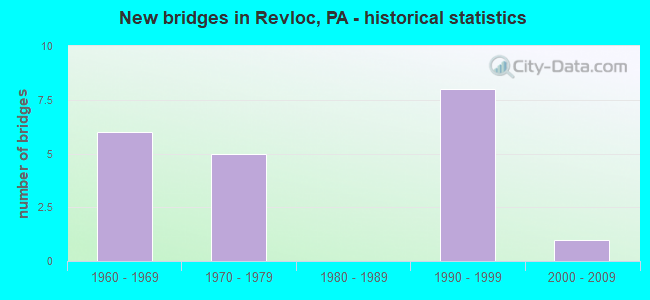
- New bridges - historical statistics
- 61960-1969
- 51970-1979
- 81990-1999
- 12000-2009

- Reconstructed bridges - Historical Statistics
- 52000-2009
- 22010-2019


- Bridge Condition - Deck
- 12.5%Very good
- 75.0%Good
- 12.5%Satisfactory

- Bridge Condition - Superstructure
- 12.5%Good
- 87.5%Satisfactory

- Bridge Condition - Substructure
- 12.5%Very good
- 50.0%Good
- 37.5%Satisfactory
Find on map >> Show street view
Structure Number: 8469, Location: OVER US 22 (Lat: 40.464156, Lng: -78.763883), Route carried "on" structure: US 219, Year Built: 1966, Year Reconstructed: 2011, Status: Open, Structure Length: 5.82m (19.09ft), Average Daily Traffic: 4,635 (year 2020), Truck Traffic: 12%, Average Future Daily Traffic: 6,522 (year 2032), Design Load: HS 20, Features Intersected: US 22
Minimum Vertical Clearance: 30+ m (98+ ft), Kilometerpoint: 28.954, Lanes on structure: 3, Lanes under structure: 6, Base Highway Network: Yes, Owner: State Highway Agency, Approaching Roadway Width: 14.9m (48.9ft), Skew: 12 degrees, Material/Design: Steel, Design/Construction: Stringer/Multi-beam, Number Of Spans In Main Unit: 1, Number Of Approach Spans: 2, Length of Maximum Span: 34.7m (113.8ft), Curb or Sidewalk Widths: Left: 0.2m (0.7ft), Right: 0.2m (0.7ft), Curb-To-Curb Width: 14.0m (45.9ft), Out-to-Out Width: 15.1m (49.5ft)
Condition: Deck: Good, Superstructure: Satisfactory, Substructure: Satisfactory, Operating Rating: 61.7 metric tons, Method Used To Determine Operating Rating: Load Factor (LF), Inventory Rating: 37.2 metric tons, Method Used To Determine Inventory Rating: Load Factor (LF), Structural Evaluation: Equal to present minimum criteria, Deck Geometry: Somewhat better than minimum adequacy, Underclear: High priority of corrective action, Approach Roadway Alignment: Equal to present desirable criteria, Length Of Structure Improvement: 6.70m (21.98ft), Designated Inspection Frequency: Every 24 months, Inspection Date: April 2021, Deck Structure Type: Concrete Cast-file-Place, Wearing Surface/Protective System: Wearing Surface: Latex Concrete
Find on map >> Show street view
Structure Number: 847, Location: OVER US 22 (Lat: 40.463853, Lng: -78.764250), Route carried "on" structure: US 219, Year Built: 1966, Year Reconstructed: 2011, Status: Open, Structure Length: 5.82m (19.09ft), Average Daily Traffic: 4,251 (year 2020), Truck Traffic: 13%, Average Future Daily Traffic: 5,378 (year 2032), Design Load: HS 20, Features Intersected: US 22
Minimum Vertical Clearance: 30+ m (98+ ft), Kilometerpoint: 28.912, Lanes on structure: 3, Lanes under structure: 6, Base Highway Network: Yes, Owner: State Highway Agency, Approaching Roadway Width: 14.3m (46.9ft), Skew: 12 degrees, Material/Design: Steel, Design/Construction: Stringer/Multi-beam, Number Of Spans In Main Unit: 1, Number Of Approach Spans: 2, Length of Maximum Span: 34.7m (113.8ft), Curb or Sidewalk Widths: Left: 0.2m (0.7ft), Right: 0.2m (0.7ft), Curb-To-Curb Width: 14.0m (45.9ft), Out-to-Out Width: 15.1m (49.5ft)
Condition: Deck: Good, Superstructure: Satisfactory, Substructure: Satisfactory, Operating Rating: 61.7 metric tons, Method Used To Determine Operating Rating: Load Factor (LF), Inventory Rating: 37.2 metric tons, Method Used To Determine Inventory Rating: Load Factor (LF), Structural Evaluation: Equal to present minimum criteria, Deck Geometry: Somewhat better than minimum adequacy, Underclear: High priority of corrective action, Approach Roadway Alignment: Equal to present desirable criteria, Length Of Structure Improvement: 6.70m (21.98ft), Designated Inspection Frequency: Every 24 months, Inspection Date: April 2021, Deck Structure Type: Concrete Cast-file-Place, Wearing Surface/Protective System: Wearing Surface: Latex Concrete
Find on map >> Show street view
Structure Number: 8473, Location: 0.7 MILE NORTH OF TR 22 (Lat: 40.474117, Lng: -78.762614), Route carried "on" structure: US 219, Year Built: 1975, Year Reconstructed: 2006, Status: Open, Structure Length: 6.34m (20.80ft), Average Daily Traffic: 4,635 (year 2020), Truck Traffic: 12%, Average Future Daily Traffic: 6,522 (year 2032), Design Load: HS 20, Features Intersected: SR 3034
Minimum Vertical Clearance: 30+ m (98+ ft), Kilometerpoint: 30.100, Lanes on structure: 2, Lanes under structure: 2, Base Highway Network: Yes, Owner: State Highway Agency, Approaching Roadway Width: 11.6m (38.1ft), Skew: 11 degrees, Material/Design: Prestressed concrete, Design/Construction: Stringer/Multi-beam, Number Of Spans In Main Unit: 3, Length of Maximum Span: 20.4m (66.9ft), Curb or Sidewalk Widths: Left: 0.2m (0.7ft), Right: 0.2m (0.7ft), Curb-To-Curb Width: 12.8m (42.0ft), Out-to-Out Width: 13.9m (45.6ft)
Condition: Deck: Good, Superstructure: Satisfactory, Substructure: Satisfactory, Operating Rating: 79.8 metric tons, Method Used To Determine Operating Rating: Load Factor (LF), Inventory Rating: 32.7 metric tons, Method Used To Determine Inventory Rating: Load Factor (LF), Structural Evaluation: Equal to present minimum criteria, Deck Geometry: Equal to present desirable criteria, Underclear: Superior to present desirable criteria, Approach Roadway Alignment: Equal to present desirable criteria, Length Of Structure Improvement: 7.30m (23.95ft), Designated Inspection Frequency: Every 24 months, Inspection Date: May 2021, Deck Structure Type: Concrete Cast-file-Place, Wearing Surface/Protective System: Wearing Surface: Latex Concrete, Deck Protection: Epoxy Coated Reinforcing
Find on map >> Show street view
Structure Number: 8475, Location: 0.5 MILE SOUTH OF TR 422 (Lat: 40.483250, Lng: -78.753361), Route carried "on" structure: US 219, Year Built: 1975, Year Reconstructed: 2006, Status: Open, Structure Length: 4.45m (14.60ft), Average Daily Traffic: 4,635 (year 2020), Truck Traffic: 12%, Average Future Daily Traffic: 6,522 (year 2032), Design Load: HS 20, Features Intersected: RAILS TO TRAILS
Minimum Vertical Clearance: 30+ m (98+ ft), Kilometerpoint: 31.012, Lanes on structure: 2, Base Highway Network: Yes, Owner: State Highway Agency, Approaching Roadway Width: 11.6m (38.1ft), Skew: 10 degrees, Material/Design: Prestressed concrete, Design/Construction: Box Beam or Girders - Single/Spread, Number Of Spans In Main Unit: 3, Length of Maximum Span: 14.3m (46.9ft), Curb or Sidewalk Widths: Left: 0.2m (0.7ft), Right: 0.2m (0.7ft), Curb-To-Curb Width: 12.8m (42.0ft), Out-to-Out Width: 13.9m (45.6ft)
Condition: Deck: Good, Superstructure: Satisfactory, Substructure: Good, Operating Rating: 58.1 metric tons, Method Used To Determine Operating Rating: Load Factor (LF), Inventory Rating: 34.5 metric tons, Method Used To Determine Inventory Rating: Load Factor (LF), Structural Evaluation: Equal to present minimum criteria, Deck Geometry: Equal to present desirable criteria, Approach Roadway Alignment: Equal to present desirable criteria, Length Of Structure Improvement: 5.40m (17.72ft), Designated Inspection Frequency: Every 24 months, Inspection Date: May 2021, Bridge Improvement Cost: $58,000, Roadway Improvement Cost: $172,000, Total Project Cost: $788,000, Deck Structure Type: Concrete Cast-file-Place, Wearing Surface/Protective System: Wearing Surface: Latex Concrete, Deck Protection: Epoxy Coated Reinforcing
Find on map >> Show street view
Structure Number: 8477, Location: 0.5 MILE SOUTH OF TR 422 (Lat: 40.483364, Lng: -78.753808), Route carried "on" structure: US 219, Year Built: 1975, Year Reconstructed: 2006, Status: Open, Structure Length: 4.45m (14.60ft), Average Daily Traffic: 4,251 (year 2020), Truck Traffic: 13%, Average Future Daily Traffic: 5,378 (year 2032), Design Load: HS 20, Features Intersected: RAILS TO TRAILS
Minimum Vertical Clearance: 30+ m (98+ ft), Kilometerpoint: 31.001, Lanes on structure: 2, Base Highway Network: Yes, Owner: State Highway Agency, Approaching Roadway Width: 11.6m (38.1ft), Skew: 10 degrees, Material/Design: Prestressed concrete, Design/Construction: Box Beam or Girders - Single/Spread, Number Of Spans In Main Unit: 3, Length of Maximum Span: 14.3m (46.9ft), Curb or Sidewalk Widths: Left: 0.2m (0.7ft), Right: 0.2m (0.7ft), Curb-To-Curb Width: 12.8m (42.0ft), Out-to-Out Width: 13.9m (45.6ft)
Condition: Deck: Satisfactory, Superstructure: Satisfactory, Substructure: Good, Operating Rating: 58.1 metric tons, Method Used To Determine Operating Rating: Load Factor (LF), Inventory Rating: 34.5 metric tons, Method Used To Determine Inventory Rating: Load Factor (LF), Structural Evaluation: Equal to present minimum criteria, Deck Geometry: Equal to present desirable criteria, Approach Roadway Alignment: Equal to present desirable criteria, Length Of Structure Improvement: 5.40m (17.72ft), Designated Inspection Frequency: Every 24 months, Inspection Date: May 2021, Bridge Improvement Cost: $58,000, Roadway Improvement Cost: $172,000, Total Project Cost: $788,000, Deck Structure Type: Concrete Cast-file-Place, Wearing Surface/Protective System: Wearing Surface: Latex Concrete, Deck Protection: Epoxy Coated Reinforcing
Find on map >> Show street view
Structure Number: 8478, Location: OVER TR 422 (Lat: 40.489564, Lng: -78.748308), Route carried "on" structure: US 219, Year Built: 1990, Year Reconstructed: 2018, Status: Open, Structure Length: 6.13m (20.11ft), Average Daily Traffic: 2,794 (year 2020), Truck Traffic: 19%, Average Future Daily Traffic: 3,140 (year 2032), Design Load: HS 25 or greater, Features Intersected: US 422 & SR 1036
Minimum Vertical Clearance: 30+ m (98+ ft), Kilometerpoint: 32.224, Lanes on structure: 2, Lanes under structure: 10, Base Highway Network: Yes, Owner: State Highway Agency, Approaching Roadway Width: 11.6m (38.1ft), Skew: 10 degrees, Material/Design: Prestressed concrete, Design/Construction: Stringer/Multi-beam, Number Of Spans In Main Unit: 3, Length of Maximum Span: 38.4m (126.0ft), Curb or Sidewalk Widths: Left: 0.2m (0.7ft), Right: 0.2m (0.7ft), Curb-To-Curb Width: 12.2m (40.0ft), Out-to-Out Width: 13.0m (42.7ft)
Condition: Deck: Good, Superstructure: Satisfactory, Substructure: Good, Operating Rating: 90.7 metric tons, Method Used To Determine Operating Rating: Load Factor (LF), Inventory Rating: 43.5 metric tons, Method Used To Determine Inventory Rating: Load Factor (LF), Structural Evaluation: Equal to present minimum criteria, Deck Geometry: Better than present minimum criteria, Underclear: Equal to present minimum criteria, Approach Roadway Alignment: Equal to present desirable criteria, Length Of Structure Improvement: 7.00m (22.97ft), Designated Inspection Frequency: Every 24 months, Inspection Date: May 2021, Deck Structure Type: Concrete Cast-file-Place, Wearing Surface/Protective System: Wearing Surface: Latex Concrete, Deck Protection: Epoxy Coated Reinforcing
Find on map >> Show street view
Structure Number: 8479, Location: OVER TR 422 (Lat: 40.489667, Lng: -78.748714), Route carried "on" structure: US 219, Year Built: 1990, Year Reconstructed: 2018, Status: Open, Structure Length: 6.52m (21.39ft), Average Daily Traffic: 2,902 (year 2020), Truck Traffic: 26%, Average Future Daily Traffic: 2,952 (year 2032), Design Load: HS 25 or greater, Features Intersected: US 422
Minimum Vertical Clearance: 30+ m (98+ ft), Kilometerpoint: 32.235, Lanes on structure: 2, Lanes under structure: 5, Base Highway Network: Yes, Owner: State Highway Agency, Approaching Roadway Width: 11.6m (38.1ft), Skew: 10 degrees, Material/Design: Prestressed concrete, Design/Construction: Stringer/Multi-beam, Number Of Spans In Main Unit: 3, Length of Maximum Span: 38.4m (126.0ft), Curb or Sidewalk Widths: Left: 0.2m (0.7ft), Right: 0.2m (0.7ft), Curb-To-Curb Width: 12.2m (40.0ft), Out-to-Out Width: 13.0m (42.7ft)
Condition: Deck: Good, Superstructure: Satisfactory, Substructure: Good, Operating Rating: 96.2 metric tons, Method Used To Determine Operating Rating: Load Factor (LF), Inventory Rating: 44.5 metric tons, Method Used To Determine Inventory Rating: Load Factor (LF), Structural Evaluation: Equal to present minimum criteria, Deck Geometry: Better than present minimum criteria, Underclear: Somewhat better than minimum adequacy, Approach Roadway Alignment: Equal to present desirable criteria, Length Of Structure Improvement: 7.50m (24.61ft), Designated Inspection Frequency: Every 48 months, Inspection Date: May 2019, Deck Structure Type: Concrete Cast-file-Place, Wearing Surface/Protective System: Wearing Surface: Latex Concrete, Deck Protection: Epoxy Coated Reinforcing
Find on map >> Show street view
Structure Number: 45643, Location: 3 MILE EAST OF NANTY GLO (Lat: 40.513417, Lng: -78.754528), Route carried "on" structure: State highway , Year Built: 2009, Status: Open, Structure Length: 1.58m (5.18ft), Average Daily Traffic: 552 (year 2022), Truck Traffic: 3%, Average Future Daily Traffic: 494 (year 2032), Design Load: HL 93, Features Intersected: S. BR. BLACKLICK CREEK, Facility Carried by Structure: SR 3034
Minimum Vertical Clearance: 30+ m (98+ ft), Kilometerpoint: 6.235, Lanes on structure: 2, Owner: State Highway Agency, Approaching Roadway Width: 8.2m (26.9ft), Material/Design: Prestressed concrete, Design/Construction: Box Beam or Girders - Single/Spread, Number Of Spans In Main Unit: 1, Length of Maximum Span: 15.2m (49.9ft), Curb or Sidewalk Widths: Left: 0.2m (0.7ft), Right: 0.2m (0.7ft), Curb-To-Curb Width: 8.5m (27.9ft), Out-to-Out Width: 9.6m (31.5ft)
Condition: Deck: Very good, Superstructure: Good, Substructure: Very good, Channel: Good, Operating Rating: 57.2 metric tons, Method Used To Determine Operating Rating: Load and Resistance Factor (LRFR), Inventory Rating: 39.9 metric tons, Method Used To Determine Inventory Rating: Load and Resistance Factor (LRFR), Structural Evaluation: Better than present minimum criteria, Deck Geometry: Somewhat better than minimum adequacy, Waterway Adequacy: Equal to present desirable criteria, Approach Roadway Alignment: Better than present minimum criteria, Designated Inspection Frequency: Every 24 months, Inspection Date: April 2020, Deck Structure Type: Concrete Cast-file-Place, Wearing Surface/Protective System: Wearing Surface: Monolithic Concrete, Deck Protection: Epoxy Coated Reinforcing
Find on map >> Show street view
Structure Number: 8469, Location: OVER US 22 (Lat: 40.464156, Lng: -78.763883), Route carried "under" structure: US 22, Year Built: 1966, Structure Length: 0. m, Average Daily Traffic: 12,256 (year 2022), Truck Traffic: 11%, Features Intersected: US 22, Facility Carried by Structure: US 219 NBL
Minimum Vertical Clearance: 4.60m (15.09ft), Kilometerpoint: 15.976, Lanes on structure: 3, Lanes under structure: 3, Material/Design: Steel, Design/Construction: Stringer/Multi-beam, Length of Maximum Span: 34.7m (113.8ft)
Find on map >> Show street view
Structure Number: 8469, Location: OVER US 22 (Lat: 40.464156, Lng: -78.763883), Route carried "under" structure: US 22, Year Built: 1966, Structure Length: 0. m, Average Daily Traffic: 11,423 (year 2022), Truck Traffic: 10%, Features Intersected: US 22, Facility Carried by Structure: US 219 NBL
Minimum Vertical Clearance: 4.72m (15.49ft), Kilometerpoint: 15.997, Lanes on structure: 3, Lanes under structure: 3, Material/Design: Steel, Design/Construction: Stringer/Multi-beam, Length of Maximum Span: 34.7m (113.8ft)
Find on map >> Show street view
Structure Number: 847, Location: OVER US 22 (Lat: 40.463853, Lng: -78.764250), Route carried "under" structure: US 22, Year Built: 1966, Structure Length: 0. m, Average Daily Traffic: 11,423 (year 2022), Truck Traffic: 10%, Features Intersected: US 22, Facility Carried by Structure: US 219 SBL
Minimum Vertical Clearance: 4.70m (15.42ft), Kilometerpoint: 15.997, Lanes on structure: 3, Lanes under structure: 3, Material/Design: Steel, Design/Construction: Stringer/Multi-beam, Length of Maximum Span: 34.7m (113.8ft)
Find on map >> Show street view
Structure Number: 847, Location: OVER US 22 (Lat: 40.463853, Lng: -78.764250), Route carried "under" structure: US 22, Year Built: 1966, Structure Length: 0. m, Average Daily Traffic: 12,256 (year 2022), Truck Traffic: 11%, Features Intersected: US 22, Facility Carried by Structure: US 219 SBL
Minimum Vertical Clearance: 4.60m (15.09ft), Kilometerpoint: 15.976, Lanes on structure: 3, Lanes under structure: 3, Material/Design: Steel, Design/Construction: Stringer/Multi-beam, Length of Maximum Span: 34.7m (113.8ft)
Find on map >> Show street view
Structure Number: 8473, Location: 0.7 MILE NORTH OF TR 22 (Lat: 40.474117, Lng: -78.762614), Route carried "under" structure: State highway , Year Built: 1975, Structure Length: 0. m, Average Daily Traffic: 552 (year 2022), Truck Traffic: 3%, Features Intersected: SR 3034, Facility Carried by Structure: US 219 NBL
Minimum Vertical Clearance: 10.36m (33.99ft), Kilometerpoint: 7.324, Lanes on structure: 2, Lanes under structure: 2, Material/Design: Prestressed concrete, Design/Construction: Stringer/Multi-beam, Length of Maximum Span: 20.4m (66.9ft)
Find on map >> Show street view
Structure Number: 8474, Location: 0.7 MILE NORTH OF TR 22 (Lat: 40.473589, Lng: -78.763469), Route carried "under" structure: State highway , Year Built: 1975, Structure Length: 0. m, Average Daily Traffic: 552 (year 2022), Truck Traffic: 3%, Features Intersected: SR 3034, Facility Carried by Structure: US 219 SBL
Minimum Vertical Clearance: 12.80m (41.99ft), Kilometerpoint: 7.324, Lanes on structure: 2, Lanes under structure: 2, Material/Design: Prestressed concrete, Design/Construction: Stringer/Multi-beam, Length of Maximum Span: 23.5m (77.1ft)
Find on map >> Show street view
Structure Number: 8478, Location: OVER TR 422 (Lat: 40.489564, Lng: -78.748308), Route carried "under" structure: US 422, Year Built: 1990, Structure Length: 0. m, Average Daily Traffic: 4,235 (year 2020), Truck Traffic: 21%, Features Intersected: US 422 & SR 1036, Facility Carried by Structure: US 219 NBL
Minimum Vertical Clearance: 4.67m (15.32ft), Kilometerpoint: 13.152, Lanes on structure: 2, Lanes under structure: 3, Material/Design: Prestressed concrete, Design/Construction: Stringer/Multi-beam, Length of Maximum Span: 38.4m (126.0ft)
Find on map >> Show street view
Structure Number: 8478, Location: OVER TR 422 (Lat: 40.489564, Lng: -78.748308), Route carried "under" structure: US 422, Year Built: 1990, Structure Length: 0. m, Average Daily Traffic: 4,249 (year 2020), Truck Traffic: 18%, Features Intersected: US 422 & SR 1036, Facility Carried by Structure: US 219 NBL
Minimum Vertical Clearance: 4.72m (15.49ft), Kilometerpoint: 13.168, Lanes on structure: 2, Lanes under structure: 2, Material/Design: Prestressed concrete, Design/Construction: Stringer/Multi-beam, Length of Maximum Span: 38.4m (126.0ft)
Find on map >> Show street view
Structure Number: 8478, Location: OVER TR 422 (Lat: 40.489564, Lng: -78.748308), Route carried "under" structure: State highway , Year Built: 1990, Structure Length: 0. m, Average Daily Traffic: 3,258 (year 2020), Truck Traffic: 8%, Features Intersected: US 422 & SR 1036, Facility Carried by Structure: US 219 NBL
Minimum Vertical Clearance: 4.72m (15.49ft), Kilometerpoint: 0.000, Lanes on structure: 2, Lanes under structure: 2, Material/Design: Prestressed concrete, Design/Construction: Stringer/Multi-beam, Length of Maximum Span: 38.4m (126.0ft)
Find on map >> Show street view
Structure Number: 8478, Location: OVER TR 422 (Lat: 40.489564, Lng: -78.748308), Route carried "under" structure: State highway , Year Built: 1990, Structure Length: 0. m, Average Daily Traffic: 3,258 (year 2020), Truck Traffic: 8%, Features Intersected: US 422 & SR 1036, Facility Carried by Structure: US 219 NBL
Minimum Vertical Clearance: 4.67m (15.32ft), Kilometerpoint: 0.000, Lanes on structure: 2, Lanes under structure: 3, Material/Design: Prestressed concrete, Design/Construction: Stringer/Multi-beam, Length of Maximum Span: 38.4m (126.0ft)
Find on map >> Show street view
Structure Number: 8479, Location: OVER TR 422 (Lat: 40.489667, Lng: -78.748714), Route carried "under" structure: US 422, Year Built: 1990, Structure Length: 0. m, Average Daily Traffic: 4,235 (year 2020), Truck Traffic: 21%, Features Intersected: US 422, Facility Carried by Structure: US 219 SBL
Minimum Vertical Clearance: 5.43m (17.81ft), Kilometerpoint: 13.152, Lanes on structure: 2, Lanes under structure: 3, Material/Design: Prestressed concrete, Design/Construction: Stringer/Multi-beam, Length of Maximum Span: 38.4m (126.0ft)
Find on map >> Show street view
Structure Number: 8479, Location: OVER TR 422 (Lat: 40.489667, Lng: -78.748714), Route carried "under" structure: US 422, Year Built: 1990, Structure Length: 0. m, Average Daily Traffic: 4,249 (year 2020), Truck Traffic: 18%, Features Intersected: US 422, Facility Carried by Structure: US 219 SBL
Minimum Vertical Clearance: 5.51m (18.08ft), Kilometerpoint: 13.168, Lanes on structure: 2, Lanes under structure: 2, Material/Design: Prestressed concrete, Design/Construction: Stringer/Multi-beam, Length of Maximum Span: 38.4m (126.0ft)