Bridge Statistics for Reiffton, Pennsylvania (PA)
Condition, Traffic, Stress, Structural Evaluation, Project Costs
- National Bridge Inventory (NBI) Statistics
- 14Number of bridges
- 148ft / 45.3mTotal length
- $2,647,000Total costs
- 301,458Total average daily traffic
- 18,409Total average daily truck traffic
- National Bridge Inventory (NBI) Registered Bridges for Reiffton
- No street view available for this location
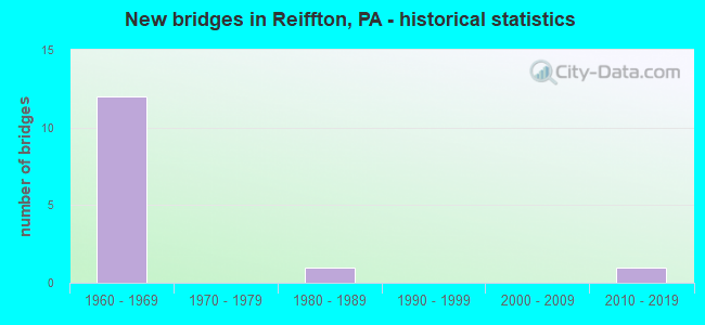
- New bridges - historical statistics
- 121960-1969
- 11980-1989
- 12010-2019

- Reconstructed bridges - Historical Statistics
- 51980-1989
- 01990-1999
- 12000-2009


- Bridge Condition - Deck
- 37.5%Good
- 25.0%Satisfactory
- 25.0%Fair
- 12.5%Poor

- Bridge Condition - Superstructure
- 25.0%Good
- 37.5%Satisfactory
- 25.0%Fair
- 12.5%Poor

- Bridge Condition - Substructure
- 37.5%Good
- 37.5%Satisfactory
- 25.0%Fair
Find on map >> Show street view
Structure Number: 474, Location: US422 JCT (I-176) (Lat: 40.306681, Lng: -75.898192), Route carried "on" structure: Interstate 176, Year Built: 1962, Year Reconstructed: 2013, Status: Open, Structure Length: 2.26m (7.41ft), Average Daily Traffic: 22,176 (year 2021), Truck Traffic: 10%, Average Future Daily Traffic: 26,904 (year 2032), Design Load: HL 93, Features Intersected: US 422(LR 793)
Minimum Vertical Clearance: 30+ m (98+ ft), Kilometerpoint: 17.655, Lanes on structure: 2, Lanes under structure: 8, Base Highway Network: Yes, Owner: State Highway Agency, Approaching Roadway Width: 15.8m (51.8ft), Skew: 31 degrees, Material/Design: Prestressed concrete, Design/Construction: Box Beam or Girders - Multiple, Number Of Spans In Main Unit: 1, Length of Maximum Span: 21.9m (71.9ft), Curb-To-Curb Width: 14.8m (48.6ft), Out-to-Out Width: 17.2m (56.4ft)
Condition: Deck: Good, Superstructure: Good, Substructure: Good, Operating Rating: 68.4 metric tons, Method Used To Determine Operating Rating: Assigned ratings based on Load and Resistance Factor Design (LRFD) reported by rating factor (RF) using HL93 loadings, Inventory Rating: 43.1 metric tons, Method Used To Determine Inventory Rating: Assigned ratings based on Load and Resistance Factor Design (LRFD) reported by rating factor (RF) using HL93 loadings, Structural Evaluation: Better than present minimum criteria, Deck Geometry: Superior to present desirable criteria, Underclear: Meets minimum limits, Approach Roadway Alignment: Better than present minimum criteria, Length Of Structure Improvement: 2.90m (9.51ft), Designated Inspection Frequency: Every 24 months, Inspection Date: November 2020, Bridge Improvement Cost: $32,000, Roadway Improvement Cost: $94,000, Total Project Cost: $432,000, Deck Structure Type: Concrete Cast-file-Place, Wearing Surface/Protective System: Wearing Surface: Monolithic Concrete, Deck Protection: Epoxy Coated Reinforcing
Find on map >> Show street view
Structure Number: 4857, Location: E.OF I-176 OVERPASS (Lat: 40.305775, Lng: -75.895086), Route carried "on" structure: US 422, Year Built: 1963, Year Reconstructed: 1988, Status: Open, Structure Length: 17.68m (58.01ft), Average Daily Traffic: 45,382 (year 2021), Truck Traffic: 6%, Average Future Daily Traffic: 60,028 (year 2032), Design Load: HS 20, Features Intersected: SCHUYLKILL RIVER
Minimum Vertical Clearance: 30+ m (98+ ft), Kilometerpoint: 33.444, Lanes on structure: 4, Base Highway Network: Yes, Owner: State Highway Agency, Approaching Roadway Width: 21.9m (71.9ft), Skew: 32 degrees, Material/Design: Steel continuous, Design/Construction: Girder and Floorbeam System, Number Of Spans In Main Unit: 4, Length of Maximum Span: 46.6m (152.9ft), Curb-To-Curb Width: 20.7m (67.9ft), Out-to-Out Width: 23.0m (75.5ft)
Condition: Deck: Satisfactory, Superstructure: Fair, Substructure: Good, Channel: Satisfactory, Operating Rating: 47.2 metric tons, Method Used To Determine Operating Rating: Load Factor (LF), Inventory Rating: 28.1 metric tons, Method Used To Determine Inventory Rating: Load Factor (LF), Structural Evaluation: Somewhat better than minimum adequacy, Deck Geometry: Equal to present minimum criteria, Waterway Adequacy: Superior to present desirable criteria, Approach Roadway Alignment: Equal to present desirable criteria, Length Of Structure Improvement: 18.40m (60.37ft), Designated Inspection Frequency: Every 24 months, Critical Feature Inspection Frequency: Every 24 months, Underwater Inspection Frequency: Every 60 months, Other Special Inspection Frequency: Every 6 months, Inspection Date: November 2020, Critical Feature Inspection Date: November 2020, Underwater Inspection Date: November 2020, Other Special Inspection Date: May 2021, Bridge Improvement Cost: $100,000, Roadway Improvement Cost: $294,000, Total Project Cost: $1,347,000, Deck Structure Type: Concrete Cast-file-Place, Wearing Surface/Protective System: Wearing Surface: Bituminous, Membrane: Preformed Fabric
Find on map >> Show street view
Structure Number: 4858, Location: READING BYPASS (Lat: 40.305214, Lng: -75.889239), Route carried "on" structure: US 422, Year Built: 1963, Year Reconstructed: 1988, Status: Open, Structure Length: 4.91m (16.11ft), Average Daily Traffic: 45,382 (year 2021), Truck Traffic: 6%, Average Future Daily Traffic: 60,028 (year 2032), Design Load: HS 20, Features Intersected: NORFOLK/SOUTHERN RR
Minimum Vertical Clearance: 30+ m (98+ ft), Kilometerpoint: 33.444, Lanes on structure: 4, Base Highway Network: Yes, Owner: State Highway Agency, Approaching Roadway Width: 20.7m (67.9ft), Skew: 34 degrees, Material/Design: Steel continuous, Design/Construction: Stringer/Multi-beam, Number Of Spans In Main Unit: 3, Length of Maximum Span: 17.7m (58.1ft), Curb or Sidewalk Widths: Left: 0.2m (0.7ft), Right: 0.2m (0.7ft), Curb-To-Curb Width: 19.9m (65.3ft), Out-to-Out Width: 21.8m (71.5ft)
Condition: Deck: Fair, Superstructure: Satisfactory, Substructure: Satisfactory, Operating Rating: 68.0 metric tons, Method Used To Determine Operating Rating: Load Factor (LF), Inventory Rating: 40.8 metric tons, Method Used To Determine Inventory Rating: Load Factor (LF), Structural Evaluation: Equal to present minimum criteria, Deck Geometry: Equal to present minimum criteria, Underclear: High priority of corrective action, Approach Roadway Alignment: Equal to present desirable criteria, Length Of Structure Improvement: 5.90m (19.36ft), Designated Inspection Frequency: Every 24 months, Inspection Date: August 2020, Deck Structure Type: Concrete Cast-file-Place, Wearing Surface/Protective System: Wearing Surface: Bituminous, Membrane: Preformed Fabric
Find on map >> Show street view
Structure Number: 4859, Location: READING BYPASS (Lat: 40.305478, Lng: -75.886958), Route carried "on" structure: US 422, Year Built: 1963, Year Reconstructed: 1988, Status: Open, Structure Length: 0.94m (3.08ft), Average Daily Traffic: 45,382 (year 2021), Truck Traffic: 6%, Average Future Daily Traffic: 60,028 (year 2032), Design Load: HS 20, Features Intersected: TWP RD 443
Minimum Vertical Clearance: 30+ m (98+ ft), Kilometerpoint: 34.432, Lanes on structure: 4, Lanes under structure: 2, Base Highway Network: Yes, Owner: State Highway Agency, Approaching Roadway Width: 20.7m (67.9ft), Skew: 31 degrees, Material/Design: Prestressed concrete, Design/Construction: Box Beam or Girders - Single/Spread, Number Of Spans In Main Unit: 1, Length of Maximum Span: 8.5m (27.9ft), Curb-To-Curb Width: 19.9m (65.3ft), Out-to-Out Width: 21.8m (71.5ft)
Condition: Deck: Fair, Superstructure: Satisfactory, Substructure: Fair, Operating Rating: 46.3 metric tons, Method Used To Determine Operating Rating: Load Factor (LF), Inventory Rating: 27.2 metric tons, Method Used To Determine Inventory Rating: Load Factor (LF), Structural Evaluation: Somewhat better than minimum adequacy, Deck Geometry: Equal to present minimum criteria, Underclear: Equal to present minimum criteria, Approach Roadway Alignment: Equal to present desirable criteria, Length Of Structure Improvement: 1.60m (5.25ft), Designated Inspection Frequency: Every 24 months, Inspection Date: May 2020, Bridge Improvement Cost: $8,000, Roadway Improvement Cost: $24,000, Total Project Cost: $109,000, Deck Structure Type: Concrete Cast-file-Place, Wearing Surface/Protective System: Wearing Surface: Bituminous, Membrane: Preformed Fabric
Find on map >> Show street view
Structure Number: 5058, Location: INT WITH US 422 BYPASS (Lat: 40.307892, Lng: -75.864675), Route carried "on" structure: Business US 422B, Year Built: 1962, Year Reconstructed: 1987, Status: Open, Structure Length: 4.88m (16.01ft), Average Daily Traffic: 6,769 (year 2020), Truck Traffic: 3%, Average Future Daily Traffic: 14,823 (year 2032), Design Load: HS 20, Features Intersected: SR 422(LR 793)W.B.
Minimum Vertical Clearance: 30+ m (98+ ft), Kilometerpoint: 0.000, Lanes on structure: 2, Lanes under structure: 2, Base Highway Network: Yes, Owner: State Highway Agency, Approaching Roadway Width: 12.2m (40.0ft), Skew: 4 degrees, Material/Design: Prestressed concrete, Design/Construction: Box Beam or Girders - Single/Spread, Number Of Spans In Main Unit: 3, Length of Maximum Span: 20.4m (66.9ft), Curb-To-Curb Width: 12.2m (40.0ft), Out-to-Out Width: 13.3m (43.6ft)
Condition: Deck: Good, Superstructure: Satisfactory, Substructure: Satisfactory, Operating Rating: 61.7 metric tons, Method Used To Determine Operating Rating: Load Factor (LF), Inventory Rating: 21.8 metric tons, Method Used To Determine Inventory Rating: Load Factor (LF), Structural Evaluation: Somewhat better than minimum adequacy, Deck Geometry: Better than present minimum criteria, Underclear: High priority of corrective action, Approach Roadway Alignment: Equal to present desirable criteria, Length Of Structure Improvement: 5.80m (19.03ft), Designated Inspection Frequency: Every 24 months, Inspection Date: October 2021, Bridge Improvement Cost: $36,000, Roadway Improvement Cost: $107,000, Total Project Cost: $488,000, Deck Structure Type: Concrete Cast-file-Place, Wearing Surface/Protective System: Wearing Surface: Latex Concrete
Find on map >> Show street view
Structure Number: 51, Location: E.NEVERSINK RD. (Lat: 40.306753, Lng: -75.875975), Route carried "on" structure: Spur State highway , Year Built: 1962, Year Reconstructed: 1985, Status: Open, Structure Length: 5.52m (18.11ft), Average Daily Traffic: 11,310 (year 2020), Truck Traffic: 4%, Average Future Daily Traffic: 21,112 (year 2032), Design Load: HS 20, Features Intersected: US 422 (LR 793), Facility Carried by Structure: SR 2039(LR146SPE)
Minimum Vertical Clearance: 30+ m (98+ ft), Kilometerpoint: 0.000, Lanes on structure: 2, Lanes under structure: 8, Owner: State Highway Agency, Approaching Roadway Width: 11.0m (36.1ft), Skew: 3 degrees, Material/Design: Prestressed concrete, Design/Construction: Box Beam or Girders - Multiple, Number Of Spans In Main Unit: 1, Number Of Approach Spans: 2, Length of Maximum Span: 27.1m (88.9ft), Curb-To-Curb Width: 12.2m (40.0ft), Out-to-Out Width: 13.3m (43.6ft)
Condition: Deck: Satisfactory, Superstructure: Fair, Substructure: Fair, Operating Rating: 58.1 metric tons, Method Used To Determine Operating Rating: Load Factor (LF), Inventory Rating: 10.9 metric tons, Method Used To Determine Inventory Rating: Load Factor (LF), Structural Evaluation: High priority of corrective action, Deck Geometry: Somewhat better than minimum adequacy, Underclear: High priority of corrective action, Approach Roadway Alignment: Equal to present desirable criteria, Length Of Structure Improvement: 6.50m (21.33ft), Designated Inspection Frequency: Every 24 months, Inspection Date: Febuary 2021, Bridge Improvement Cost: $20,000, Roadway Improvement Cost: $59,000, Total Project Cost: $271,000, Deck Structure Type: Concrete Cast-file-Place, Wearing Surface/Protective System: Wearing Surface: Epoxy Overlay
Find on map >> Show street view
Structure Number: 5358, Location: ALTHOUSE MILL BRIDGE (Lat: 40.311292, Lng: -75.848228), Route carried "on" structure: Other road 434, Year Built: 1980, Status: Posted for load, Structure Length: 2.26m (7.41ft), Average Daily Traffic: 11,973 (year 2015), Truck Traffic: 2%, Average Future Daily Traffic: 13,522 (year 2035), Design Load: HS 20, Features Intersected: ANTIETAM CREEK, Facility Carried by Structure: GIBRALTAR ROAD
Minimum Vertical Clearance: 30+ m (98+ ft), Kilometerpoint: 0.000, Lanes on structure: 2, Owner: County Highway Agency, Approaching Roadway Width: 11.0m (36.1ft), Skew: 4 degrees, Material/Design: Prestressed concrete, Design/Construction: Box Beam or Girders - Multiple, Number Of Spans In Main Unit: 1, Length of Maximum Span: 21.9m (71.9ft), Curb or Sidewalk Widths: Left: 0.2m (0.7ft), Right: 1.6m (5.2ft), Curb-To-Curb Width: 11.0m (36.1ft), Out-to-Out Width: 13.5m (44.3ft)
Condition: Deck: Poor, Superstructure: Poor, Substructure: Satisfactory, Channel: Satisfactory, Operating Rating: 29.9 metric tons, Method Used To Determine Operating Rating: Load Factor (LF), Structural Evaluation: High priority of corrective action, Deck Geometry: Meets minimum limits, Waterway Adequacy: Better than present minimum criteria, Approach Roadway Alignment: Equal to present desirable criteria, Bridge Posting: Required (Relationship of Operating Rating to Maximum Legal Load: 20.0 - 29.9% below), Length Of Structure Improvement: 3.00m (9.84ft), Designated Inspection Frequency: Every 24 months, Other Special Inspection Frequency: Every 12 months, Inspection Date: June 2020, Other Special Inspection Date: June 2021, Deck Structure Type: Other, Wearing Surface/Protective System: Wearing Surface: Bituminous
Find on map >> Show street view
Structure Number: 48147, Location: 0.2MI S OF US422 (Lat: 40.303528, Lng: -75.899825), Route carried "on" structure: Interstate 176, Year Built: 2013, Status: Open, Structure Length: 6.89m (22.60ft), Average Daily Traffic: 22,176 (year 2021), Truck Traffic: 10%, Average Future Daily Traffic: 13,300 (year 2032), Design Load: HL 93, Features Intersected: NORFOLK SOUTHERN RR
Minimum Vertical Clearance: 30+ m (98+ ft), Kilometerpoint: 17.655, Lanes on structure: 2, Base Highway Network: Yes, Owner: State Highway Agency, Approaching Roadway Width: 15.8m (51.8ft), Skew: 12 degrees, Material/Design: Steel, Design/Construction: Stringer/Multi-beam, Number Of Spans In Main Unit: 1, Length of Maximum Span: 68.6m (225.1ft), Curb or Sidewalk Widths: Left: 0.2m (0.7ft), Right: 0.2m (0.7ft), Curb-To-Curb Width: 30.4m (99.7ft), Out-to-Out Width: 33.6m (110.2ft)
Condition: Deck: Good, Superstructure: Good, Substructure: Good, Operating Rating: 61.6 metric tons, Method Used To Determine Operating Rating: Assigned ratings based on Load and Resistance Factor Design (LRFD) reported by rating factor (RF) using HL93 loadings, Inventory Rating: 38.9 metric tons, Method Used To Determine Inventory Rating: Assigned ratings based on Load and Resistance Factor Design (LRFD) reported by rating factor (RF) using HL93 loadings, Structural Evaluation: Better than present minimum criteria, Deck Geometry: Superior to present desirable criteria, Underclear: High priority of corrective action, Approach Roadway Alignment: Equal to present desirable criteria, Designated Inspection Frequency: Every 48 months, Inspection Date: November 2018, Deck Structure Type: Concrete Cast-file-Place, Wearing Surface/Protective System: Wearing Surface: Monolithic Concrete, Deck Protection: Epoxy Coated Reinforcing
Find on map >> Show street view
Structure Number: 474, Location: US422 JCT (I-176) (Lat: 40.306681, Lng: -75.898192), Route carried "under" structure: US 422, Year Built: 1962, Structure Length: 0. m, Average Daily Traffic: 21,803 (year 2021), Truck Traffic: 5%, Features Intersected: US 422(LR 793), Facility Carried by Structure: I-176(LR 1011)
Minimum Vertical Clearance: 4.91m (16.11ft), Kilometerpoint: 33.444, Lanes on structure: 2, Lanes under structure: 4, Material/Design: Prestressed concrete, Design/Construction: Box Beam or Girders - Multiple, Length of Maximum Span: 21.9m (71.9ft)
Find on map >> Show street view
Structure Number: 474, Location: US422 JCT (I-176) (Lat: 40.306681, Lng: -75.898192), Route carried "under" structure: US 422, Year Built: 1962, Structure Length: 0. m, Average Daily Traffic: 23,579 (year 2021), Truck Traffic: 6%, Features Intersected: US 422(LR 793), Facility Carried by Structure: I-176(LR 1011)
Minimum Vertical Clearance: 4.79m (15.72ft), Kilometerpoint: 33.405, Lanes on structure: 2, Lanes under structure: 4, Material/Design: Prestressed concrete, Design/Construction: Box Beam or Girders - Multiple, Length of Maximum Span: 21.9m (71.9ft)
Find on map >> Show street view
Structure Number: 4859, Location: READING BYPASS (Lat: 40.305478, Lng: -75.886958), Route carried "under" structure: City street , Year Built: 1963, Structure Length: 0. m, Average Daily Traffic: 321 (year 1994), Truck Traffic: 1%, Features Intersected: TWP RD 443, Facility Carried by Structure: US 422 (LR 793)
Minimum Vertical Clearance: 4.48m (14.70ft), Kilometerpoint: 0.000, Lanes on structure: 4, Lanes under structure: 2, Material/Design: Prestressed concrete, Design/Construction: Box Beam or Girders - Single/Spread, Length of Maximum Span: 8.5m (27.9ft)
Find on map >> Show street view
Structure Number: 5058, Location: INT WITH US 422 BYPASS (Lat: 40.307892, Lng: -75.864675), Route carried "under" structure: US 422, Year Built: 1962, Structure Length: 0. m, Average Daily Traffic: 15,167 (year 2021), Truck Traffic: 5%, Features Intersected: SR 422(LR 793)W.B.
Minimum Vertical Clearance: 4.52m (14.83ft), Kilometerpoint: 35.882, Lanes on structure: 2, Lanes under structure: 2, Material/Design: Prestressed concrete, Design/Construction: Box Beam or Girders - Single/Spread, Length of Maximum Span: 20.4m (66.9ft)
Find on map >> Show street view
Structure Number: 51, Location: E.NEVERSINK RD. (Lat: 40.306753, Lng: -75.875975), Route carried "under" structure: US 422, Year Built: 1962, Structure Length: 0. m, Average Daily Traffic: 14,871 (year 2021), Truck Traffic: 6%, Features Intersected: US 422 (LR 793), Facility Carried by Structure: SR 2039(LR146SPE)
Minimum Vertical Clearance: 4.57m (14.99ft), Kilometerpoint: 35.381, Lanes on structure: 2, Lanes under structure: 4, Material/Design: Prestressed concrete, Design/Construction: Box Beam or Girders - Multiple, Length of Maximum Span: 27.1m (88.9ft)
Find on map >> Show street view
Structure Number: 51, Location: E.NEVERSINK RD. (Lat: 40.306753, Lng: -75.875975), Route carried "under" structure: US 422, Year Built: 1962, Structure Length: 0. m, Average Daily Traffic: 15,167 (year 2021), Truck Traffic: 5%, Features Intersected: US 422 (LR 793), Facility Carried by Structure: SR 2039(LR146SPE)
Minimum Vertical Clearance: 4.88m (16.01ft), Kilometerpoint: 35.343, Lanes on structure: 2, Lanes under structure: 4, Material/Design: Prestressed concrete, Design/Construction: Box Beam or Girders - Multiple, Length of Maximum Span: 27.1m (88.9ft)