Bridge Statistics for Reidville, South Carolina (SC)
Condition, Traffic, Stress, Structural Evaluation, Project Costs
- National Bridge Inventory (NBI) Statistics
- 18Number of bridges
- 207ft / 63.0mTotal length
- $2,272,000Total costs
- 59,275Total average daily traffic
- 4,997Total average daily truck traffic
- 93,858Total future (year 2040) average daily traffic
- National Bridge Inventory (NBI) Registered Bridges for Reidville
- No street view available for this location
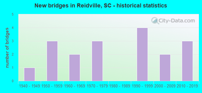
- New bridges - historical statistics
- 11940-1949
- 31950-1959
- 21960-1969
- 31970-1979
- 41990-1999
- 22000-2009
- 32010-2019


- Bridge Condition - Deck
- 47.1%Very good
- 41.2%Good
- 5.9%Satisfactory
- 5.9%Fair

- Bridge Condition - Superstructure
- 47.1%Very good
- 47.1%Good
- 5.9%Fair

- Bridge Condition - Substructure
- 41.2%Very good
- 17.6%Good
- 17.6%Satisfactory
- 17.6%Fair
- 5.9%Serious

- Bridge Condition - Channel
- 33.3%Very good
- 44.4%Good
- 16.7%Satisfactory
- 5.6%Poor
Find on map >> Show street view
Structure Number: 1563, Location: 7.0 MI SE DUNCAN (Lat: 34.836364, Lng: -82.105286), Route carried "on" structure: State highway 62, Year Built: 1948, Status: Open, Structure Length: 0.85m (2.79ft), Average Daily Traffic: 1,250 (year 2020), Truck Traffic: 4%, Average Future Daily Traffic: 2,863 (year 2040), Design Load: H 15, Features Intersected: TRIB TO BENS CREEK
Minimum Vertical Clearance: 30+ m (98+ ft), Kilometerpoint: 10.882, Lanes on structure: 2, Owner: State Highway Agency, Approaching Roadway Width: 5.6m (18.4ft), Material/Design: Concrete, Design/Construction: Culvert, Number Of Spans In Main Unit: 3, Length of Maximum Span: 2.4m (7.9ft), Curb-To-Curb Width: 7.3m (24.0ft), Out-to-Out Width: 9.1m (29.9ft)
Condition: Channel: Satisfactory, Culverts: Satisfactory, Operating Rating: 31.4 metric tons, Method Used To Determine Operating Rating: Load and Resistance Factor Rating (LRFR) rating reported by rating factor(RF) method using HL-93 loadings, Inventory Rating: 24.3 metric tons, Method Used To Determine Inventory Rating: Load and Resistance Factor Rating (LRFR) rating reported by rating factor(RF) method using HL-93 loadings, Structural Evaluation: Equal to present minimum criteria, Deck Geometry: Meets minimum limits, Waterway Adequacy: Better than present minimum criteria, Approach Roadway Alignment: Equal to present desirable criteria, Length Of Structure Improvement: 0.85m (2.79ft), Designated Inspection Frequency: Every 24 months, Inspection Date: September 2021
Find on map >> Show street view
Structure Number: 2088, Location: 7.5 MI SE GREER (Lat: 34.889069, Lng: -82.102806), Route carried "on" structure: State highway 82, Year Built: 1954, Status: Open, Structure Length: 8.23m (27.00ft), Average Daily Traffic: 6,800 (year 2020), Truck Traffic: 8%, Average Future Daily Traffic: 10,200 (year 2040), Design Load: HS 15, Features Intersected: SOUTH TYGER RIVER
Minimum Vertical Clearance: 30+ m (98+ ft), Kilometerpoint: 1.569, Lanes on structure: 2, Owner: State Highway Agency, Approaching Roadway Width: 7.7m (25.3ft), Material/Design: Concrete, Design/Construction: Tee Beam, Number Of Spans In Main Unit: 9, Length of Maximum Span: 9.1m (29.9ft), Curb-To-Curb Width: 7.9m (25.9ft), Out-to-Out Width: 9.4m (30.8ft)
Condition: Deck: Fair, Superstructure: Fair, Substructure: Fair, Channel: Good, Operating Rating: 28.5 metric tons, Method Used To Determine Operating Rating: Load and Resistance Factor Rating (LRFR) rating reported by rating factor(RF) method using HL-93 loadings, Inventory Rating: 21.7 metric tons, Method Used To Determine Inventory Rating: Load and Resistance Factor Rating (LRFR) rating reported by rating factor(RF) method using HL-93 loadings, Structural Evaluation: Somewhat better than minimum adequacy, Deck Geometry: High priority of corrective action, Waterway Adequacy: Better than present minimum criteria, Approach Roadway Alignment: Equal to present desirable criteria, Bridge Posting: Required (Relationship of Operating Rating to Maximum Legal Load: 0.1 - 9.9% below), Length Of Structure Improvement: 9.29m (30.48ft), Designated Inspection Frequency: Every 23 months, Underwater Inspection Frequency: Every 60 months, Inspection Date: September 2021, Underwater Inspection Date: December 2021, Bridge Improvement Cost: $1,175,000, Roadway Improvement Cost: $294,000, Total Project Cost: $1,763,000 ( Estimate for 2021), Deck Structure Type: Concrete Cast-file-Place, Wearing Surface/Protective System: Wearing Surface: Monolithic Concrete
Find on map >> Show street view
Structure Number: 2415, Location: 7.0 MI SE LYMAN (Lat: 34.853031, Lng: -82.079297), Route carried "on" structure: State highway 194, Year Built: 1956, Status: Open, Structure Length: 2.56m (8.40ft), Average Daily Traffic: 250 (year 2020), Truck Traffic: 5%, Average Future Daily Traffic: 320 (year 2040), Design Load: H 10, Features Intersected: BR-S TYGER RIV
Minimum Vertical Clearance: 30+ m (98+ ft), Kilometerpoint: 0.510, Lanes on structure: 2, Owner: State Highway Agency, Approaching Roadway Width: 5.6m (18.4ft), Material/Design: Concrete, Design/Construction: Slab, Number Of Spans In Main Unit: 6, Length of Maximum Span: 4.3m (14.1ft), Curb-To-Curb Width: 7.4m (24.3ft), Out-to-Out Width: 7.8m (25.6ft)
Condition: Deck: Good, Superstructure: Good, Substructure: Fair, Channel: Poor, Operating Rating: 20.4 metric tons, Method Used To Determine Operating Rating: Load and Resistance Factor Rating (LRFR) rating reported by rating factor(RF) method using HL-93 loadings, Inventory Rating: 15.9 metric tons, Method Used To Determine Inventory Rating: Load and Resistance Factor Rating (LRFR) rating reported by rating factor(RF) method using HL-93 loadings, Structural Evaluation: Meets minimum limits, Deck Geometry: Somewhat better than minimum adequacy, Waterway Adequacy: Equal to present desirable criteria, Approach Roadway Alignment: Equal to present desirable criteria, Length Of Structure Improvement: 2.56m (8.40ft), Designated Inspection Frequency: Every 23 months, Inspection Date: September 2021, Deck Structure Type: Concrete Precast Panels, Wearing Surface/Protective System: Wearing Surface: Bituminous
Find on map >> Show street view
Structure Number: 2843, Location: 10.0 MI SW SPARTANBURG (Lat: 34.872872, Lng: -82.081269), Route carried "on" structure: State highway 296, Year Built: 1958, Status: Open, Structure Length: 7.62m (25.00ft), Average Daily Traffic: 9,400 (year 2020), Truck Traffic: 3%, Average Future Daily Traffic: 13,630 (year 2040), Design Load: HS 15, Features Intersected: SOUTH TYGER RIVER
Minimum Vertical Clearance: 30+ m (98+ ft), Kilometerpoint: 11.560, Lanes on structure: 2, Owner: State Highway Agency, Approaching Roadway Width: 8.5m (27.9ft), Material/Design: Concrete, Design/Construction: Tee Beam, Number Of Spans In Main Unit: 8, Length of Maximum Span: 12.2m (40.0ft), Curb-To-Curb Width: 8.5m (27.9ft), Out-to-Out Width: 9.6m (31.5ft)
Condition: Deck: Good, Superstructure: Good, Substructure: Fair, Channel: Good, Operating Rating: 27.9 metric tons, Method Used To Determine Operating Rating: Load and Resistance Factor Rating (LRFR) rating reported by rating factor(RF) method using HL-93 loadings, Inventory Rating: 21.4 metric tons, Method Used To Determine Inventory Rating: Load and Resistance Factor Rating (LRFR) rating reported by rating factor(RF) method using HL-93 loadings, Structural Evaluation: Somewhat better than minimum adequacy, Deck Geometry: Meets minimum limits, Waterway Adequacy: Equal to present desirable criteria, Approach Roadway Alignment: Equal to present desirable criteria, Bridge Posting: Required (Relationship of Operating Rating to Maximum Legal Load: 0.1 - 9.9% below), Length Of Structure Improvement: 7.62m (25.00ft), Designated Inspection Frequency: Every 24 months, Underwater Inspection Frequency: Every 60 months, Inspection Date: January 2020, Underwater Inspection Date: January 2021, Deck Structure Type: Concrete Cast-file-Place, Wearing Surface/Protective System: Wearing Surface: Bituminous
Find on map >> Show street view
Structure Number: 2844, Location: 7.3 MI SW SPARTANBURG (Lat: 34.894489, Lng: -82.040386), Route carried "on" structure: State highway 296, Year Built: 2002, Status: Open, Structure Length: 7.47m (24.51ft), Average Daily Traffic: 22,700 (year 2020), Truck Traffic: 13%, Average Future Daily Traffic: 32,915 (year 2040), Design Load: HS 20, Features Intersected: MIDDLE TYGER RIVER
Minimum Vertical Clearance: 30+ m (98+ ft), Kilometerpoint: 16.285, Lanes on structure: 4, Owner: State Highway Agency, Approaching Roadway Width: 25.0m (82.0ft), Material/Design: Prestressed concrete continuous, Design/Construction: Stringer/Multi-beam, Number Of Spans In Main Unit: 3, Length of Maximum Span: 29.0m (95.1ft), Curb-To-Curb Width: 25.1m (82.3ft), Out-to-Out Width: 25.9m (85.0ft)
Condition: Deck: Very good, Superstructure: Very good, Substructure: Very good, Channel: Good, Operating Rating: 35.6 metric tons, Method Used To Determine Operating Rating: Load and Resistance Factor Rating (LRFR) rating reported by rating factor(RF) method using HL-93 loadings, Inventory Rating: 20.7 metric tons, Method Used To Determine Inventory Rating: Load and Resistance Factor Rating (LRFR) rating reported by rating factor(RF) method using HL-93 loadings, Structural Evaluation: Somewhat better than minimum adequacy, Deck Geometry: Superior to present desirable criteria, Waterway Adequacy: Equal to present desirable criteria, Approach Roadway Alignment: Equal to present desirable criteria, Length Of Structure Improvement: 7.47m (24.51ft), Designated Inspection Frequency: Every 24 months, Inspection Date: January 2020, Deck Structure Type: Concrete Cast-file-Place, Wearing Surface/Protective System: Wearing Surface: Monolithic Concrete
Find on map >> Show street view
Structure Number: 4218, Location: 5.0 MI SE DUNCAN (Lat: 34.899222, Lng: -82.057161), Route carried "on" structure: State highway 591, Year Built: 1963, Status: Open, Structure Length: 7.32m (24.02ft), Average Daily Traffic: 1,800 (year 2020), Truck Traffic: 2%, Average Future Daily Traffic: 2,700 (year 2040), Design Load: HS 15, Features Intersected: MIDDLE TYGER RIVER
Minimum Vertical Clearance: 30+ m (98+ ft), Kilometerpoint: 1.225, Lanes on structure: 2, Owner: State Highway Agency, Approaching Roadway Width: 6.8m (22.3ft), Material/Design: Concrete, Design/Construction: Tee Beam, Number Of Spans In Main Unit: 8, Length of Maximum Span: 9.1m (29.9ft), Curb-To-Curb Width: 7.9m (25.9ft), Out-to-Out Width: 10.1m (33.1ft)
Condition: Deck: Satisfactory, Superstructure: Good, Substructure: Good, Channel: Very good, Operating Rating: 26.6 metric tons, Method Used To Determine Operating Rating: Load and Resistance Factor Rating (LRFR) rating reported by rating factor(RF) method using HL-93 loadings, Inventory Rating: 20.4 metric tons, Method Used To Determine Inventory Rating: Load and Resistance Factor Rating (LRFR) rating reported by rating factor(RF) method using HL-93 loadings, Structural Evaluation: Somewhat better than minimum adequacy, Deck Geometry: Meets minimum limits, Waterway Adequacy: Better than present minimum criteria, Approach Roadway Alignment: Equal to present minimum criteria, Length Of Structure Improvement: 7.32m (24.02ft), Designated Inspection Frequency: Every 24 months, Inspection Date: August 2021, Deck Structure Type: Concrete Cast-file-Place, Wearing Surface/Protective System: Wearing Surface: Monolithic Concrete
Find on map >> Show street view
Structure Number: 4664, Location: 5.8 MI SE LYMAN (Lat: 34.867694, Lng: -82.106319), Route carried "on" structure: State highway 224, Year Built: 1965, Status: Posted for load, Structure Length: 2.29m (7.51ft), Average Daily Traffic: 850 (year 2020), Truck Traffic: 5%, Average Future Daily Traffic: 1,088 (year 2040), Design Load: H 10, Features Intersected: TRIB TO S. TYGER RIVER
Minimum Vertical Clearance: 30+ m (98+ ft), Kilometerpoint: 1.088, Lanes on structure: 2, Owner: State Highway Agency, Approaching Roadway Width: 5.8m (19.0ft), Material/Design: Concrete, Design/Construction: Slab, Number Of Spans In Main Unit: 5, Length of Maximum Span: 4.6m (15.1ft), Curb-To-Curb Width: 7.9m (25.9ft), Out-to-Out Width: 8.4m (27.6ft)
Condition: Deck: Good, Superstructure: Good, Substructure: Satisfactory, Channel: Very good, Operating Rating: 18.8 metric tons, Method Used To Determine Operating Rating: Load and Resistance Factor Rating (LRFR) rating reported by rating factor(RF) method using HL-93 loadings, Inventory Rating: 14.6 metric tons, Method Used To Determine Inventory Rating: Load and Resistance Factor Rating (LRFR) rating reported by rating factor(RF) method using HL-93 loadings, Structural Evaluation: Meets minimum limits, Deck Geometry: Somewhat better than minimum adequacy, Waterway Adequacy: Equal to present desirable criteria, Approach Roadway Alignment: Equal to present desirable criteria, Bridge Posting: Required (Relationship of Operating Rating to Maximum Legal Load: 30.0 - 39.9% below), Length Of Structure Improvement: 2.29m (7.51ft), Designated Inspection Frequency: Every 23 months, Inspection Date: September 2021, Deck Structure Type: Concrete Precast Panels, Wearing Surface/Protective System: Wearing Surface: Bituminous
Find on map >> Show street view
Structure Number: 6189, Location: 4.0 MI S LYMAN (Lat: 34.887439, Lng: -82.126375), Route carried "on" structure: County highway 660, Year Built: 2017, Status: Open, Structure Length: 1.37m (4.49ft), Average Daily Traffic: 200 (year 2020), Truck Traffic: 5%, Average Future Daily Traffic: 256 (year 2040), Design Load: H 10, Features Intersected: TRIB SOUTH TIGER RIV
Minimum Vertical Clearance: 30+ m (98+ ft), Kilometerpoint: 0.293, Lanes on structure: 2, Owner: County Highway Agency, Approaching Roadway Width: 6.7m (22.0ft), Material/Design: Prestressed concrete, Design/Construction: Slab, Number Of Spans In Main Unit: 1, Length of Maximum Span: 13.7m (44.9ft), Curb-To-Curb Width: 8.3m (27.2ft), Out-to-Out Width: 9.1m (29.9ft)
Condition: Deck: Very good, Superstructure: Very good, Substructure: Very good, Channel: Satisfactory, Operating Rating: 43.4 metric tons, Method Used To Determine Operating Rating: Load and Resistance Factor Rating (LRFR) rating reported by rating factor(RF) method using HL-93 loadings, Inventory Rating: 33.4 metric tons, Method Used To Determine Inventory Rating: Load and Resistance Factor Rating (LRFR) rating reported by rating factor(RF) method using HL-93 loadings, Structural Evaluation: Equal to present desirable criteria, Deck Geometry: Somewhat better than minimum adequacy, Waterway Adequacy: Better than present minimum criteria, Approach Roadway Alignment: Equal to present minimum criteria, Length Of Structure Improvement: 1.37m (4.49ft), Designated Inspection Frequency: Every 24 months, Inspection Date: October 2021, Deck Structure Type: Concrete Precast Panels, Wearing Surface/Protective System: Wearing Surface: Bituminous
Find on map >> Show street view
Structure Number: 6778, Location: 11.0 MI SW SPARTANBURG (Lat: 34.843319, Lng: -82.071656), Route carried "on" structure: State highway 417, Year Built: 1975, Status: Open, Structure Length: 4.57m (14.99ft), Average Daily Traffic: 4,100 (year 2020), Truck Traffic: 4%, Average Future Daily Traffic: 9,389 (year 2040), Design Load: HS 20, Features Intersected: BENS CREEK
Minimum Vertical Clearance: 30+ m (98+ ft), Kilometerpoint: 11.122, Lanes on structure: 2, Owner: State Highway Agency, Approaching Roadway Width: 8.1m (26.6ft), Material/Design: Prestressed concrete, Design/Construction: Stringer/Multi-beam, Number Of Spans In Main Unit: 1, Number Of Approach Spans: 3, Length of Maximum Span: 18.3m (60.0ft), Curb-To-Curb Width: 12.3m (40.4ft), Out-to-Out Width: 13.3m (43.6ft)
Condition: Deck: Very good, Superstructure: Very good, Substructure: Good, Channel: Good, Operating Rating: 49.9 metric tons, Method Used To Determine Operating Rating: Load and Resistance Factor Rating (LRFR) rating reported by rating factor(RF) method using HL-93 loadings, Inventory Rating: 38.6 metric tons, Method Used To Determine Inventory Rating: Load and Resistance Factor Rating (LRFR) rating reported by rating factor(RF) method using HL-93 loadings, Structural Evaluation: Better than present minimum criteria, Deck Geometry: Equal to present minimum criteria, Waterway Adequacy: Equal to present desirable criteria, Approach Roadway Alignment: Equal to present desirable criteria, Length Of Structure Improvement: 4.57m (14.99ft), Designated Inspection Frequency: Every 24 months, Inspection Date: January 2022, Deck Structure Type: Concrete Cast-file-Place, Wearing Surface/Protective System: Wearing Surface: Bituminous
Find on map >> Show street view
Structure Number: 6779, Location: 10.5 MI SW SPARTANBURG (Lat: 34.848783, Lng: -82.066864), Route carried "on" structure: State highway 417, Year Built: 1975, Status: Open, Structure Length: 7.32m (24.02ft), Average Daily Traffic: 3,700 (year 2021), Truck Traffic: 8%, Average Future Daily Traffic: 8,473 (year 2041), Design Load: HS 20, Features Intersected: SOUTH TYGER RIVER
Minimum Vertical Clearance: 30+ m (98+ ft), Kilometerpoint: 11.899, Lanes on structure: 2, Owner: State Highway Agency, Approaching Roadway Width: 8.4m (27.6ft), Material/Design: Prestressed concrete, Design/Construction: Stringer/Multi-beam, Number Of Spans In Main Unit: 3, Number Of Approach Spans: 2, Length of Maximum Span: 18.3m (60.0ft), Curb-To-Curb Width: 12.3m (40.4ft), Out-to-Out Width: 13.3m (43.6ft)
Condition: Deck: Very good, Superstructure: Very good, Substructure: Serious, Channel: Very good, Operating Rating: 49.9 metric tons, Method Used To Determine Operating Rating: Load and Resistance Factor Rating (LRFR) rating reported by rating factor(RF) method using HL-93 loadings, Inventory Rating: 38.6 metric tons, Method Used To Determine Inventory Rating: Load and Resistance Factor Rating (LRFR) rating reported by rating factor(RF) method using HL-93 loadings, Structural Evaluation: High priority of corrective action, Deck Geometry: Equal to present minimum criteria, Waterway Adequacy: Equal to present desirable criteria, Approach Roadway Alignment: Equal to present desirable criteria, Length Of Structure Improvement: 8.34m (27.36ft), Designated Inspection Frequency: Every 12 months, Inspection Date: January 2022, Bridge Improvement Cost: $351,000, Roadway Improvement Cost: $18,000, Total Project Cost: $386,000 ( Estimate for 2022), Deck Structure Type: Concrete Cast-file-Place, Wearing Surface/Protective System: Wearing Surface: Bituminous
Find on map >> Show street view
Structure Number: 6934, Location: 6.5 MI SE GREER (Lat: 34.886164, Lng: -82.119739), Route carried "on" structure: State highway 82, Year Built: 2010, Status: Open, Structure Length: 2.13m (6.99ft), Average Daily Traffic: 6,800 (year 2020), Truck Traffic: 8%, Average Future Daily Traffic: 10,200 (year 2040), Design Load: HS 20, Features Intersected: TRIB TO S.TYGER RIVER
Minimum Vertical Clearance: 30+ m (98+ ft), Kilometerpoint: 3.365, Lanes on structure: 2, Owner: State Highway Agency, Approaching Roadway Width: 7.6m (24.9ft), Material/Design: Prestressed concrete, Design/Construction: Slab, Number Of Spans In Main Unit: 1, Number Of Approach Spans: 2, Length of Maximum Span: 21.3m (69.9ft), Curb-To-Curb Width: 10.1m (33.1ft), Out-to-Out Width: 11.0m (36.1ft)
Condition: Deck: Very good, Superstructure: Very good, Substructure: Very good, Channel: Very good, Operating Rating: 64.5 metric tons, Method Used To Determine Operating Rating: Load and Resistance Factor Rating (LRFR) rating reported by rating factor(RF) method using HL-93 loadings, Inventory Rating: 49.9 metric tons, Method Used To Determine Inventory Rating: Load and Resistance Factor Rating (LRFR) rating reported by rating factor(RF) method using HL-93 loadings, Structural Evaluation: Equal to present desirable criteria, Deck Geometry: Meets minimum limits, Waterway Adequacy: Better than present minimum criteria, Approach Roadway Alignment: Equal to present desirable criteria, Length Of Structure Improvement: 2.13m (6.99ft), Designated Inspection Frequency: Every 23 months, Inspection Date: September 2021, Deck Structure Type: Concrete Precast Panels, Wearing Surface/Protective System: Wearing Surface: Bituminous
Find on map >> Show street view
Structure Number: 6937, Location: 7.5 MI NW WOODRUFF (Lat: 34.842956, Lng: -82.085078), Route carried "on" structure: State highway 195, Year Built: 1976, Status: Posted for load, Structure Length: 3.20m (10.50ft), Average Daily Traffic: 275 (year 2020), Truck Traffic: 5%, Average Future Daily Traffic: 352 (year 2040), Design Load: H 15, Features Intersected: BENS CREEK
Minimum Vertical Clearance: 30+ m (98+ ft), Kilometerpoint: 4.946, Lanes on structure: 2, Owner: State Highway Agency, Approaching Roadway Width: 5.7m (18.7ft), Material/Design: Prestressed concrete, Design/Construction: Channel Beam, Number Of Spans In Main Unit: 3, Number Of Approach Spans: 1, Length of Maximum Span: 9.1m (29.9ft), Curb-To-Curb Width: 9.7m (31.8ft), Out-to-Out Width: 10.2m (33.5ft)
Condition: Deck: Good, Superstructure: Good, Substructure: Satisfactory, Channel: Good, Operating Rating: 14.9 metric tons, Method Used To Determine Operating Rating: Load and Resistance Factor Rating (LRFR) rating reported by rating factor(RF) method using HL-93 loadings, Inventory Rating: 10.0 metric tons, Method Used To Determine Inventory Rating: Load and Resistance Factor Rating (LRFR) rating reported by rating factor(RF) method using HL-93 loadings, Structural Evaluation: High priority of corrective action, Deck Geometry: Equal to present minimum criteria, Waterway Adequacy: Better than present minimum criteria, Approach Roadway Alignment: Equal to present desirable criteria, Bridge Posting: Required (Relationship of Operating Rating to Maximum Legal Load: > 39.9% below), Length Of Structure Improvement: 4.06m (13.32ft), Designated Inspection Frequency: Every 24 months, Inspection Date: September 2021, Bridge Improvement Cost: $82,000, Roadway Improvement Cost: $21,000, Total Project Cost: $123,000 ( Estimate for 2021), Deck Structure Type: Concrete Cast-file-Place, Wearing Surface/Protective System: Wearing Surface: Bituminous
Find on map >> Show street view
Structure Number: 8692, Location: 7.5 MI NW WOODRUFF (Lat: 34.823631, Lng: -82.115836), Route carried "on" structure: State highway 195, Year Built: 1993, Status: Open, Structure Length: 1.83m (6.00ft), Average Daily Traffic: 275 (year 2020), Truck Traffic: 5%, Average Future Daily Traffic: 352 (year 2040), Design Load: HS 20, Features Intersected: TRIB-BENS CK
Minimum Vertical Clearance: 30+ m (98+ ft), Kilometerpoint: 0.946, Lanes on structure: 2, Owner: State Highway Agency, Approaching Roadway Width: 6.1m (20.0ft), Material/Design: Prestressed concrete, Design/Construction: Slab, Number Of Spans In Main Unit: 1, Number Of Approach Spans: 2, Length of Maximum Span: 9.1m (29.9ft), Curb-To-Curb Width: 10.4m (34.1ft), Out-to-Out Width: 11.8m (38.7ft)
Condition: Deck: Very good, Superstructure: Very good, Substructure: Very good, Channel: Good, Operating Rating: 27.5 metric tons, Method Used To Determine Operating Rating: Load and Resistance Factor Rating (LRFR) rating reported by rating factor(RF) method using HL-93 loadings, Inventory Rating: 19.4 metric tons, Method Used To Determine Inventory Rating: Load and Resistance Factor Rating (LRFR) rating reported by rating factor(RF) method using HL-93 loadings, Structural Evaluation: Somewhat better than minimum adequacy, Deck Geometry: Better than present minimum criteria, Waterway Adequacy: Better than present minimum criteria, Approach Roadway Alignment: Equal to present desirable criteria, Length Of Structure Improvement: 1.83m (6.00ft), Designated Inspection Frequency: Every 24 months, Inspection Date: September 2021, Deck Structure Type: Concrete Precast Panels, Wearing Surface/Protective System: Wearing Surface: Monolithic Concrete
Find on map >> Show street view
Structure Number: 9272, Location: 5.0 MI N WOODRUFF (Lat: 34.827311, Lng: -82.045997), Route carried "on" structure: County highway 604, Year Built: 1997, Status: Open, Structure Length: 1.52m (4.99ft), Average Daily Traffic: 200 (year 2020), Truck Traffic: 5%, Average Future Daily Traffic: 256 (year 2040), Design Load: HS 20, Features Intersected: TRIB TO S. TYGER RV
Minimum Vertical Clearance: 30+ m (98+ ft), Kilometerpoint: 0.816, Lanes on structure: 2, Owner: County Highway Agency, Approaching Roadway Width: 7.2m (23.6ft), Material/Design: Prestressed concrete, Design/Construction: Channel Beam, Number Of Spans In Main Unit: 2, Length of Maximum Span: 7.6m (24.9ft), Curb-To-Curb Width: 8.3m (27.2ft), Out-to-Out Width: 8.5m (27.9ft)
Condition: Deck: Good, Superstructure: Good, Substructure: Very good, Channel: Good, Operating Rating: 36.3 metric tons, Method Used To Determine Operating Rating: Load and Resistance Factor Rating (LRFR) rating reported by rating factor(RF) method using HL-93 loadings, Inventory Rating: 27.9 metric tons, Method Used To Determine Inventory Rating: Load and Resistance Factor Rating (LRFR) rating reported by rating factor(RF) method using HL-93 loadings, Structural Evaluation: Better than present minimum criteria, Deck Geometry: Somewhat better than minimum adequacy, Waterway Adequacy: Better than present minimum criteria, Approach Roadway Alignment: Equal to present minimum criteria, Length Of Structure Improvement: 1.52m (4.99ft), Designated Inspection Frequency: Every 24 months, Inspection Date: November 2021, Deck Structure Type: Concrete Precast Panels, Wearing Surface/Protective System: Wearing Surface: Monolithic Concrete
Find on map >> Show street view
Structure Number: 928, Location: 1.0 MI S OF REIDVILLE (Lat: 34.850150, Lng: -82.113578), Route carried "on" structure: County highway 2289, Year Built: 1997, Status: Open, Structure Length: 1.52m (4.99ft), Average Daily Traffic: 200 (year 2020), Truck Traffic: 5%, Average Future Daily Traffic: 256 (year 2040), Design Load: HS 20, Features Intersected: BENS CR
Minimum Vertical Clearance: 30+ m (98+ ft), Kilometerpoint: 0.908, Lanes on structure: 2, Owner: County Highway Agency, Approaching Roadway Width: 6.7m (22.0ft), Material/Design: Prestressed concrete, Design/Construction: Channel Beam, Number Of Spans In Main Unit: 2, Length of Maximum Span: 7.6m (24.9ft), Curb-To-Curb Width: 8.4m (27.6ft), Out-to-Out Width: 8.5m (27.9ft)
Condition: Deck: Good, Superstructure: Good, Substructure: Good, Channel: Good, Operating Rating: 36.6 metric tons, Method Used To Determine Operating Rating: Load and Resistance Factor Rating (LRFR) rating reported by rating factor(RF) method using HL-93 loadings, Inventory Rating: 28.2 metric tons, Method Used To Determine Inventory Rating: Load and Resistance Factor Rating (LRFR) rating reported by rating factor(RF) method using HL-93 loadings, Structural Evaluation: Better than present minimum criteria, Waterway Adequacy: Better than present minimum criteria, Approach Roadway Alignment: Equal to present desirable criteria, Length Of Structure Improvement: 1.52m (4.99ft), Designated Inspection Frequency: Every 24 months, Inspection Date: November 2021, Deck Structure Type: Concrete Precast Panels, Wearing Surface/Protective System: Wearing Surface: Monolithic Concrete
Find on map >> Show street view
Structure Number: 9461, Location: 8.9 MI N WOODRUFF (Lat: 34.863561, Lng: -82.087378), Route carried "on" structure: County highway 595, Year Built: 1999, Status: Open, Structure Length: 1.52m (4.99ft), Average Daily Traffic: 200 (year 2020), Truck Traffic: 5%, Average Future Daily Traffic: 256 (year 2040), Design Load: HS 20, Features Intersected: TRIB TO SOUTH TIGER RV
Minimum Vertical Clearance: 30+ m (98+ ft), Kilometerpoint: 0.647, Lanes on structure: 2, Owner: County Highway Agency, Approaching Roadway Width: 7.6m (24.9ft), Material/Design: Prestressed concrete, Design/Construction: Channel Beam, Number Of Spans In Main Unit: 2, Length of Maximum Span: 7.6m (24.9ft), Curb-To-Curb Width: 8.3m (27.2ft), Out-to-Out Width: 8.5m (27.9ft)
Condition: Deck: Very good, Superstructure: Very good, Substructure: Very good, Channel: Very good, Operating Rating: 36.6 metric tons, Method Used To Determine Operating Rating: Load and Resistance Factor Rating (LRFR) rating reported by rating factor(RF) method using HL-93 loadings, Inventory Rating: 28.2 metric tons, Method Used To Determine Inventory Rating: Load and Resistance Factor Rating (LRFR) rating reported by rating factor(RF) method using HL-93 loadings, Structural Evaluation: Better than present minimum criteria, Deck Geometry: Somewhat better than minimum adequacy, Waterway Adequacy: Better than present minimum criteria, Approach Roadway Alignment: Equal to present minimum criteria, Length Of Structure Improvement: 1.52m (4.99ft), Designated Inspection Frequency: Every 24 months, Inspection Date: November 2021, Deck Structure Type: Concrete Precast Panels, Wearing Surface/Protective System: Wearing Surface: Monolithic Concrete
Find on map >> Show street view
Structure Number: 9917, Location: 8 MI SE OF SPARTANBURG (Lat: 34.850261, Lng: -82.119664), Route carried "on" structure: County highway 8218, Year Built: 2004, Status: Open, Structure Length: 0.91m (2.99ft), Average Daily Traffic: 75 (year 2020), Average Future Daily Traffic: 96 (year 2040), Design Load: H 10, Features Intersected: BENS CREEK
Minimum Vertical Clearance: 30+ m (98+ ft), Kilometerpoint: 1.793, Lanes on structure: 2, Owner: County Highway Agency, Approaching Roadway Width: 7.6m (24.9ft), Material/Design: Concrete, Design/Construction: Slab, Number Of Spans In Main Unit: 2, Length of Maximum Span: 4.6m (15.1ft), Curb-To-Curb Width: 7.9m (25.9ft), Out-to-Out Width: 8.4m (27.6ft)
Condition: Deck: Good, Superstructure: Good, Substructure: Satisfactory, Channel: Satisfactory, Operating Rating: 26.9 metric tons, Method Used To Determine Operating Rating: Load and Resistance Factor Rating (LRFR) rating reported by rating factor(RF) method using HL-93 loadings, Inventory Rating: 20.7 metric tons, Method Used To Determine Inventory Rating: Load and Resistance Factor Rating (LRFR) rating reported by rating factor(RF) method using HL-93 loadings, Structural Evaluation: Equal to present minimum criteria, Deck Geometry: High priority of replacement, Waterway Adequacy: Equal to present minimum criteria, Approach Roadway Alignment: Equal to present minimum criteria, Length Of Structure Improvement: 0.91m (2.99ft), Designated Inspection Frequency: Every 24 months, Inspection Date: October 2021, Deck Structure Type: Concrete Precast Panels, Wearing Surface/Protective System: Wearing Surface: Bituminous
Find on map >> Show street view
Structure Number: 9979, Location: 4 MI W OF SPARTANBURG (Lat: 34.869522, Lng: -82.127939), Route carried "on" structure: County highway 656, Year Built: 2013, Status: Open, Structure Length: 0.76m (2.49ft), Average Daily Traffic: 200 (year 2020), Truck Traffic: 5%, Average Future Daily Traffic: 256 (year 2040), Design Load: HS 20, Features Intersected: BRUSHY CREEK
Minimum Vertical Clearance: 30+ m (98+ ft), Kilometerpoint: 0.801, Lanes on structure: 2, Owner: County Highway Agency, Approaching Roadway Width: 7.1m (23.3ft), Material/Design: Concrete, Design/Construction: Slab, Number Of Spans In Main Unit: 1, Length of Maximum Span: 7.6m (24.9ft), Curb-To-Curb Width: 8.3m (27.2ft), Out-to-Out Width: 8.4m (27.6ft)
Condition: Deck: Very good, Superstructure: Very good, Substructure: Very good, Channel: Very good, Operating Rating: 36.0 metric tons, Method Used To Determine Operating Rating: Load and Resistance Factor Rating (LRFR) rating reported by rating factor(RF) method using HL-93 loadings, Inventory Rating: 27.9 metric tons, Method Used To Determine Inventory Rating: Load and Resistance Factor Rating (LRFR) rating reported by rating factor(RF) method using HL-93 loadings, Structural Evaluation: Better than present minimum criteria, Deck Geometry: High priority of corrective action, Waterway Adequacy: Equal to present minimum criteria, Approach Roadway Alignment: Equal to present minimum criteria, Length Of Structure Improvement: 0.76m (2.49ft), Designated Inspection Frequency: Every 24 months, Inspection Date: November 2021, Deck Structure Type: Concrete Precast Panels, Wearing Surface/Protective System: Wearing Surface: Monolithic Concrete