Bridge Statistics for Rehoboth, Massachusetts (MA)
Condition, Traffic, Stress, Structural Evaluation, Project Costs
- National Bridge Inventory (NBI) Statistics
- 14Number of bridges
- 112ft / 34.3mTotal length
- $26,956,000Total costs
- 295,999Total average daily traffic
- 6,101Total average daily truck traffic
- National Bridge Inventory (NBI) Registered Bridges for Rehoboth
- No street view available for this location
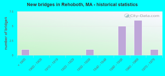
- New bridges - historical statistics
- 1Before 1900
- 11930-1939
- 51950-1959
- 61960-1969
- 11970-1979
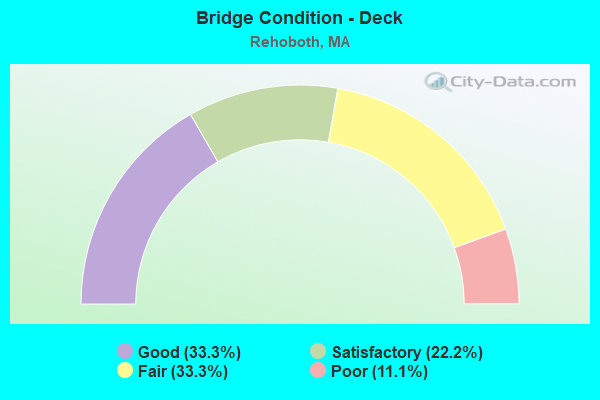
- Bridge Condition - Deck
- 33.3%Good
- 22.2%Satisfactory
- 33.3%Fair
- 11.1%Poor
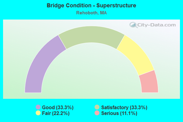
- Bridge Condition - Superstructure
- 33.3%Good
- 33.3%Satisfactory
- 22.2%Fair
- 11.1%Serious
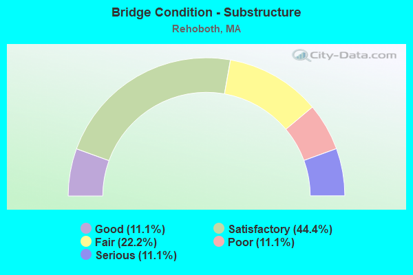
- Bridge Condition - Substructure
- 11.1%Good
- 44.4%Satisfactory
- 22.2%Fair
- 11.1%Poor
- 11.1%Serious
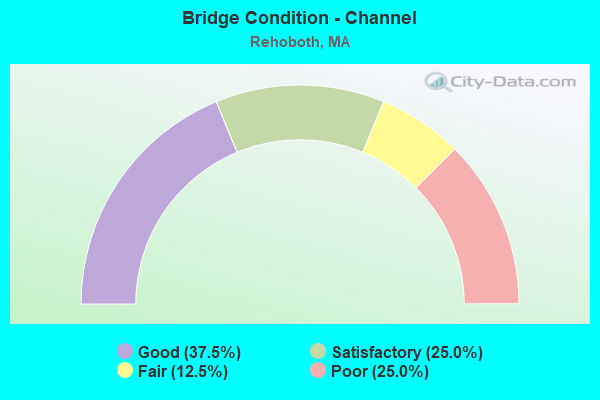
- Bridge Condition - Channel
- 37.5%Good
- 25.0%Satisfactory
- 12.5%Fair
- 25.0%Poor
Find on map >> Show street view
Structure Number: R040013N6DOTNBI, Location: 1.7 MI NE SEEKONK T.L. (Lat: 41.841078, Lng: -71.267742), Route carried "on" structure: US 44, Year Built: 1850, Year Reconstructed: 1929, Status: Open, Structure Length: 0.85m (2.79ft), Average Daily Traffic: 13,760 (year 2018), Truck Traffic: 6%, Average Future Daily Traffic: 30,796 (year 2032), Design Load: H 20, Features Intersected: WATER PALMER RIVER
Minimum Vertical Clearance: 30+ m (98+ ft), Kilometerpoint: 7.000, Lanes on structure: 2, Base Highway Network: Yes, Owner: State Highway Agency, Approaching Roadway Width: 12.2m (40.0ft), Material/Design: Masonry, Design/Construction: Arch - Deck, Number Of Spans In Main Unit: 2, Length of Maximum Span: 3.4m (11.2ft), Curb-To-Curb Width: 12.2m (40.0ft), Out-to-Out Width: 13.4m (44.0ft)
Condition: Deck: Satisfactory, Superstructure: Serious, Substructure: Serious, Channel: Poor, Operating Rating: 52.3 metric tons, Method Used To Determine Operating Rating: Allowable Stress (AS), Inventory Rating: 33.7 metric tons, Method Used To Determine Inventory Rating: Allowable Stress (AS), Structural Evaluation: High priority of corrective action, Deck Geometry: Somewhat better than minimum adequacy, Waterway Adequacy: Equal to present minimum criteria, Approach Roadway Alignment: Equal to present desirable criteria, Length Of Structure Improvement: 0.90m (2.95ft), Designated Inspection Frequency: Every 6 months, Underwater Inspection Frequency: Every 6 months, Other Special Inspection Frequency: Every 6 months, Inspection Date: August 2021, Underwater Inspection Date: December 2021, Other Special Inspection Date: Febuary 2022, Bridge Improvement Cost: $474,000, Roadway Improvement Cost: $48,000, Total Project Cost: $712,000 ( Estimate for 2022), Deck Structure Type: Concrete Cast-file-Place, Wearing Surface/Protective System: Wearing Surface: Bituminous
Find on map >> Show street view
Structure Number: R040043LWMUNNBI, Location: 1 MI E OF SEEKONK (Lat: 41.809350, Lng: -71.277914), Route carried "on" structure: City street , Year Built: 1964, Status: Open, Structure Length: 1.05m (3.44ft), Average Daily Traffic: 1,700 (year 2018), Truck Traffic: 4%, Average Future Daily Traffic: 4,422 (year 2031), Design Load: H 20, Features Intersected: WATER PALMER RIVER, Facility Carried by Structure: HWY REED ST
Minimum Vertical Clearance: 30+ m (98+ ft), Kilometerpoint: 0.708, Lanes on structure: 2, Owner: Town or Township Highway Agency, Approaching Roadway Width: 9.1m (29.9ft), Skew: 4 degrees, Material/Design: Prestressed concrete, Design/Construction: Slab, Number Of Spans In Main Unit: 1, Length of Maximum Span: 10.2m (33.5ft), Curb or Sidewalk Widths: Left: 1.5m (4.9ft), Right: 1.5m (4.9ft), Curb-To-Curb Width: 9.1m (29.9ft), Out-to-Out Width: 12.2m (40.0ft)
Condition: Deck: Good, Superstructure: Good, Substructure: Poor, Channel: Poor, Operating Rating: 60.9 metric tons, Method Used To Determine Operating Rating: Load Factor (LF), Inventory Rating: 48.0 metric tons, Method Used To Determine Inventory Rating: Load Factor (LF), Structural Evaluation: Meets minimum limits, Deck Geometry: Somewhat better than minimum adequacy, Waterway Adequacy: Better than present minimum criteria, Approach Roadway Alignment: Equal to present desirable criteria, Length Of Structure Improvement: 1.10m (3.61ft), Designated Inspection Frequency: Every 12 months, Underwater Inspection Frequency: Every 12 months, Inspection Date: October 2020, Underwater Inspection Date: November 2021, Bridge Improvement Cost: $528,000, Roadway Improvement Cost: $53,000, Total Project Cost: $793,000 ( Estimate for 2022), Deck Structure Type: Concrete Precast Panels, Wearing Surface/Protective System: Wearing Surface: Bituminous, Membrane: Built-up
Find on map >> Show street view
Structure Number: R040053WMDOTNBI, Location: .2 KM NW SWANSEA T.L. (Lat: 41.775375, Lng: -71.281003), Route carried "on" structure: US 6, Year Built: 1972, Status: Open, Structure Length: 1.95m (6.40ft), Average Daily Traffic: 13,450 (year 2020), Truck Traffic: 7%, Average Future Daily Traffic: 26,058 (year 2032), Design Load: H 20, Features Intersected: WATER PALMER RIVER
Minimum Vertical Clearance: 30+ m (98+ ft), Kilometerpoint: 9.640, Lanes on structure: 4, Owner: State Highway Agency, Approaching Roadway Width: 15.8m (51.8ft), Material/Design: Steel, Design/Construction: Stringer/Multi-beam, Number Of Spans In Main Unit: 2, Length of Maximum Span: 9.8m (32.2ft), Curb or Sidewalk Widths: Left: 1.9m (6.2ft), Right: 0.8m (2.6ft), Curb-To-Curb Width: 15.8m (51.8ft), Out-to-Out Width: 18.6m (61.0ft)
Condition: Deck: Fair, Superstructure: Satisfactory, Substructure: Fair, Channel: Fair, Operating Rating: 53.0 metric tons, Method Used To Determine Operating Rating: Allowable Stress (AS), Inventory Rating: 37.2 metric tons, Method Used To Determine Inventory Rating: Allowable Stress (AS), Structural Evaluation: Somewhat better than minimum adequacy, Deck Geometry: Meets minimum limits, Waterway Adequacy: Equal to present desirable criteria, Approach Roadway Alignment: Equal to present desirable criteria, Length Of Structure Improvement: 2.00m (6.56ft), Designated Inspection Frequency: Every 24 months, Underwater Inspection Frequency: Every 24 months, Inspection Date: August 2021, Underwater Inspection Date: June 2020, Bridge Improvement Cost: $1,462,000, Roadway Improvement Cost: $147,000, Total Project Cost: $2,194,000 ( Estimate for 2022), Deck Structure Type: Concrete Cast-file-Place, Wearing Surface/Protective System: Wearing Surface: Bituminous, Membrane: Built-up
Find on map >> Show street view
Structure Number: R040073LVMUNNBI, Location: .1 MI W OF RT 118 (Lat: 41.841833, Lng: -71.244375), Route carried "on" structure: City street , Year Built: 1955, Status: Open, Structure Length: 1.46m (4.79ft), Average Daily Traffic: 2,200 (year 2018), Truck Traffic: 8%, Average Future Daily Traffic: 3,632 (year 2031), Design Load: H 20, Features Intersected: WATER PALMER RIVER, Facility Carried by Structure: HWY COUNTY ST
Minimum Vertical Clearance: 30+ m (98+ ft), Kilometerpoint: 0.193, Lanes on structure: 2, Owner: Town or Township Highway Agency, Approaching Roadway Width: 7.9m (25.9ft), Skew: 1 degrees, Material/Design: Concrete continuous, Design/Construction: Slab, Number Of Spans In Main Unit: 3, Length of Maximum Span: 4.6m (15.1ft), Curb or Sidewalk Widths: Left: 1.5m (4.9ft), Right: 0.3m (1.0ft), Curb-To-Curb Width: 9.1m (29.9ft), Out-to-Out Width: 11.8m (38.7ft)
Condition: Deck: Good, Superstructure: Good, Substructure: Fair, Channel: Good, Operating Rating: 48.5 metric tons, Method Used To Determine Operating Rating: Allowable Stress (AS), Inventory Rating: 32.8 metric tons, Method Used To Determine Inventory Rating: Allowable Stress (AS), Structural Evaluation: Somewhat better than minimum adequacy, Deck Geometry: Meets minimum limits, Waterway Adequacy: Equal to present minimum criteria, Approach Roadway Alignment: Equal to present desirable criteria, Length Of Structure Improvement: 1.50m (4.92ft), Designated Inspection Frequency: Every 24 months, Inspection Date: October 2020, Bridge Improvement Cost: $696,000, Roadway Improvement Cost: $70,000, Total Project Cost: $1,045,000 ( Estimate for 2022), Deck Structure Type: Concrete Cast-file-Place, Wearing Surface/Protective System: Wearing Surface: Bituminous
Find on map >> Show street view
Structure Number: R040123JXMUNNBI, Location: .3 MI W OF MASON ST (Lat: 41.800472, Lng: -71.273033), Route carried "on" structure: City street , Year Built: 1969, Status: Posted for load, Structure Length: 1.71m (5.61ft), Average Daily Traffic: 2,900 (year 2018), Truck Traffic: 1%, Average Future Daily Traffic: 9,634 (year 2031), Design Load: H 20, Features Intersected: WATER PALMER RIVER, Facility Carried by Structure: HWY PROVDENCE ST
Minimum Vertical Clearance: 30+ m (98+ ft), Kilometerpoint: 2.189, Lanes on structure: 2, Owner: Town or Township Highway Agency, Approaching Roadway Width: 9.1m (29.9ft), Skew: 2 degrees, Material/Design: Steel, Design/Construction: Stringer/Multi-beam, Number Of Spans In Main Unit: 1, Length of Maximum Span: 15.8m (51.8ft), Curb or Sidewalk Widths: Left: 0.5m (1.6ft), Right: 0.5m (1.6ft), Curb-To-Curb Width: 9.1m (29.9ft), Out-to-Out Width: 10.9m (35.8ft)
Condition: Deck: Good, Superstructure: Satisfactory, Substructure: Good, Channel: Good, Operating Rating: 50.0 metric tons, Method Used To Determine Operating Rating: Load Factor (LF), Inventory Rating: 30.0 metric tons, Method Used To Determine Inventory Rating: Load Factor (LF), Structural Evaluation: Equal to present minimum criteria, Deck Geometry: Meets minimum limits, Waterway Adequacy: Superior to present desirable criteria, Approach Roadway Alignment: Equal to present desirable criteria, Length Of Structure Improvement: 1.80m (5.91ft), Designated Inspection Frequency: Every 24 months, Inspection Date: October 2020, Bridge Improvement Cost: $771,000, Roadway Improvement Cost: $78,000, Total Project Cost: $1,157,000 ( Estimate for 2022), Deck Structure Type: Concrete Cast-file-Place, Wearing Surface/Protective System: Wearing Surface: Bituminous, Membrane: Built-up
Find on map >> Show street view
Structure Number: R040173Y6DOTNBI, Location: 1.1 MI FROM SWANSEA TL (Lat: 41.781919, Lng: -71.287878), Route carried "on" structure: City street , Year Built: 1959, Status: Open, Structure Length: 8.17m (26.80ft), Average Daily Traffic: 1,300 (year 2019), Truck Traffic: 15%, Average Future Daily Traffic: 3,948 (year 2031), Design Load: H 20, Features Intersected: I 195, Facility Carried by Structure: HWY BARNEY AVE
Minimum Vertical Clearance: 30+ m (98+ ft), Kilometerpoint: 0.000, Lanes on structure: 2, Lanes under structure: 6, Owner: State Highway Agency, Approaching Roadway Width: 9.8m (32.2ft), Skew: 1 degrees, Material/Design: Steel, Design/Construction: Stringer/Multi-beam, Number Of Spans In Main Unit: 5, Length of Maximum Span: 22.6m (74.1ft), Curb or Sidewalk Widths: Left: 0.5m (1.6ft), Right: 1.5m (4.9ft), Curb-To-Curb Width: 9.8m (32.2ft), Out-to-Out Width: 12.7m (41.7ft)
Condition: Deck: Satisfactory, Superstructure: Satisfactory, Substructure: Satisfactory, Operating Rating: 54.8 metric tons, Method Used To Determine Operating Rating: Load Factor (LF), Inventory Rating: 32.8 metric tons, Method Used To Determine Inventory Rating: Load Factor (LF), Structural Evaluation: Equal to present minimum criteria, Deck Geometry: Somewhat better than minimum adequacy, Underclear: High priority of corrective action, Approach Roadway Alignment: Equal to present minimum criteria, Length Of Structure Improvement: 8.20m (26.90ft), Designated Inspection Frequency: Every 24 months, Inspection Date: May 2020, Bridge Improvement Cost: $2,784,000, Roadway Improvement Cost: $279,000, Total Project Cost: $4,177,000 ( Estimate for 2022), Deck Structure Type: Concrete Cast-file-Place, Wearing Surface/Protective System: Wearing Surface: Bituminous, Membrane: Built-up
Find on map >> Show street view
Structure Number: R040183U4DOTNBI, Location: .6 MI FROM SWANSEA T.L. (Lat: 41.778575, Lng: -71.279381), Route carried "on" structure: Interstate 195, Year Built: 1960, Status: Open, Structure Length: 4.75m (15.58ft), Average Daily Traffic: 46,696 (year 2019), Truck Traffic: 6%, Average Future Daily Traffic: 61,593 (year 2032), Design Load: H 20, Features Intersected: WATER PALMER RIVER
Minimum Vertical Clearance: 30+ m (98+ ft), Kilometerpoint: 5.954, Lanes on structure: 3, Base Highway Network: Yes, Owner: State Highway Agency, Approaching Roadway Width: 15.2m (49.9ft), Material/Design: Steel continuous, Design/Construction: Stringer/Multi-beam, Number Of Spans In Main Unit: 3, Length of Maximum Span: 20.1m (65.9ft), Curb or Sidewalk Widths: Left: 0.8m (2.6ft), Right: 0.0m, Curb-To-Curb Width: 15.2m (49.9ft), Out-to-Out Width: 17.4m (57.1ft)
Condition: Deck: Poor, Superstructure: Fair, Substructure: Satisfactory, Channel: Satisfactory, Operating Rating: 52.9 metric tons, Method Used To Determine Operating Rating: Load Factor (LF), Inventory Rating: 31.7 metric tons, Method Used To Determine Inventory Rating: Load Factor (LF), Structural Evaluation: Somewhat better than minimum adequacy, Deck Geometry: Meets minimum limits, Waterway Adequacy: Somewhat better than minimum adequacy, Approach Roadway Alignment: Equal to present minimum criteria, Length Of Structure Improvement: 4.80m (15.75ft), Designated Inspection Frequency: Every 12 months, Underwater Inspection Frequency: Every 36 months, Other Special Inspection Frequency: Every 12 months, Inspection Date: July 2021, Underwater Inspection Date: March 2020, Other Special Inspection Date: July 2021, Bridge Improvement Cost: $3,281,000, Roadway Improvement Cost: $329,000, Total Project Cost: $4,922,000 ( Estimate for 2022), Deck Structure Type: Concrete Cast-file-Place, Wearing Surface/Protective System: Wearing Surface: Bituminous, Membrane: Built-up
Find on map >> Show street view
Structure Number: R040183U5DOTNBI, Location: .6 MI FROM SWANSEA T L (Lat: 41.778992, Lng: -71.279103), Route carried "on" structure: Interstate 195, Year Built: 1960, Status: Open, Structure Length: 4.75m (15.58ft), Average Daily Traffic: 31,163 (year 2018), Truck Traffic: 3%, Average Future Daily Traffic: 61,593 (year 2032), Design Load: HS 20, Features Intersected: WATER PALMER RIVER
Minimum Vertical Clearance: 30+ m (98+ ft), Kilometerpoint: 15.449, Lanes on structure: 3, Base Highway Network: Yes, Owner: State Highway Agency, Approaching Roadway Width: 15.2m (49.9ft), Material/Design: Steel continuous, Design/Construction: Stringer/Multi-beam, Number Of Spans In Main Unit: 3, Length of Maximum Span: 20.1m (65.9ft), Curb or Sidewalk Widths: Left: 0.5m (1.6ft), Right: 0.8m (2.6ft), Curb-To-Curb Width: 15.2m (49.9ft), Out-to-Out Width: 17.4m (57.1ft)
Condition: Deck: Fair, Superstructure: Fair, Substructure: Satisfactory, Channel: Satisfactory, Operating Rating: 52.8 metric tons, Method Used To Determine Operating Rating: Load Factor (LF), Inventory Rating: 31.6 metric tons, Method Used To Determine Inventory Rating: Load Factor (LF), Structural Evaluation: Somewhat better than minimum adequacy, Deck Geometry: Meets minimum limits, Waterway Adequacy: Equal to present desirable criteria, Approach Roadway Alignment: Better than present minimum criteria, Length Of Structure Improvement: 4.80m (15.75ft), Designated Inspection Frequency: Every 24 months, Underwater Inspection Frequency: Every 36 months, Inspection Date: July 2021, Underwater Inspection Date: March 2020, Bridge Improvement Cost: $3,281,000, Roadway Improvement Cost: $329,000, Total Project Cost: $4,922,000 ( Estimate for 2022), Deck Structure Type: Concrete Cast-file-Place, Wearing Surface/Protective System: Wearing Surface: Bituminous, Membrane: Built-up
Find on map >> Show street view
Structure Number: R040193WUDOTNBI, Location: .4 MI FROM SWANSEA T.L. (Lat: 41.777953, Lng: -71.275628), Route carried "on" structure: City street , Year Built: 1958, Status: Open, Structure Length: 8.87m (29.10ft), Average Daily Traffic: 1,430 (year 2020), Average Future Daily Traffic: 4,106 (year 2033), Design Load: H 20, Features Intersected: I 195, Facility Carried by Structure: HWY MASON ST
Minimum Vertical Clearance: 30+ m (98+ ft), Kilometerpoint: 0.000, Lanes on structure: 2, Lanes under structure: 6, Owner: State Highway Agency, Approaching Roadway Width: 9.8m (32.2ft), Skew: 2 degrees, Material/Design: Steel, Design/Construction: Stringer/Multi-beam, Number Of Spans In Main Unit: 5, Length of Maximum Span: 24.4m (80.1ft), Curb or Sidewalk Widths: Left: 1.5m (4.9ft), Right: 0.0m, Curb-To-Curb Width: 9.8m (32.2ft), Out-to-Out Width: 12.7m (41.7ft)
Condition: Deck: Fair, Superstructure: Good, Substructure: Satisfactory, Operating Rating: 44.2 metric tons, Method Used To Determine Operating Rating: Allowable Stress (AS), Inventory Rating: 21.8 metric tons, Method Used To Determine Inventory Rating: Allowable Stress (AS), Structural Evaluation: Somewhat better than minimum adequacy, Deck Geometry: Somewhat better than minimum adequacy, Underclear: High priority of corrective action, Approach Roadway Alignment: Better than present minimum criteria, Length Of Structure Improvement: 8.90m (29.20ft), Designated Inspection Frequency: Every 24 months, Inspection Date: Febuary 2022, Bridge Improvement Cost: $4,440,000, Roadway Improvement Cost: $445,000, Total Project Cost: $6,661,000 ( Estimate for 2022), Deck Structure Type: Concrete Cast-file-Place, Wearing Surface/Protective System: Wearing Surface: Bituminous, Membrane: Built-up
Find on map >> Show street view
Structure Number: R040223JWMUNNBI, Location: .25 MI NW OF RTE 44 (Lat: 41.845853, Lng: -71.265308), Route carried "on" structure: City street , Year Built: 1936, Status: Open, Structure Length: 0.70m (2.30ft), Average Daily Traffic: 2,200 (year 2019), Truck Traffic: 6%, Average Future Daily Traffic: 3,317 (year 2032), Features Intersected: WATER PALMER RIVER, Facility Carried by Structure: HWY DANFORTH ST
Minimum Vertical Clearance: 30+ m (98+ ft), Kilometerpoint: 0.000, Lanes on structure: 2, Owner: Town or Township Highway Agency, Approaching Roadway Width: 8.2m (26.9ft), Material/Design: Steel, Design/Construction: Culvert, Number Of Spans In Main Unit: 3, Length of Maximum Span: 2.1m (6.9ft)
Condition: Channel: Good, Culverts: Fair, Inventory Rating: 72.6 metric tons, Method Used To Determine Inventory Rating: Load Factor (LF), Structural Evaluation: Somewhat better than minimum adequacy, Waterway Adequacy: Better than present minimum criteria, Approach Roadway Alignment: Equal to present minimum criteria, Length Of Structure Improvement: 0.90m (2.95ft), Designated Inspection Frequency: Every 24 months, Inspection Date: March 2021, Bridge Improvement Cost: $248,000, Roadway Improvement Cost: $25,000, Total Project Cost: $373,000 ( Estimate for 2022)
Find on map >> Show street view
Structure Number: R040173Y6DOTNBI, Location: 1.1 MI FROM SWANSEA T.L. (Lat: 41.766667, Lng: -71.283333), Route carried "under" structure: Interstate 195, Year Built: 1959, Structure Length: 0. m, Average Daily Traffic: 44,800 (year 0000), Features Intersected: I 195 EB, Facility Carried by Structure: HWY BARNEY AVE
Minimum Vertical Clearance: 4.42m (14.50ft), Kilometerpoint: 0.000, Lanes on structure: 4, Lanes under structure: 2, Material/Design: Steel, Design/Construction: Stringer/Multi-beam, Length of Maximum Span: 23.2m (76.1ft)
Find on map >> Show street view
Structure Number: R040173Y6DOTNBI, Location: 1.1 MI FROM SWANSEA T.L. (Lat: 41.766667, Lng: -71.283333), Route carried "under" structure: Interstate 195, Year Built: 1959, Structure Length: 0. m, Average Daily Traffic: 44,800 (year 0000), Features Intersected: I 195 WB, Facility Carried by Structure: HWY BARNEY AVE
Minimum Vertical Clearance: 4.42m (14.50ft), Kilometerpoint: 0.000, Lanes on structure: 4, Lanes under structure: 2, Material/Design: Steel, Design/Construction: Stringer/Multi-beam, Length of Maximum Span: 23.2m (76.1ft)
Find on map >> Show street view
Structure Number: R040193WUDOTNBI, Location: .4 MI FROM SWANSEA T.L. (Lat: 41.783333, Lng: -71.283333), Route carried "under" structure: Interstate 195, Year Built: 1960, Structure Length: 0. m, Average Daily Traffic: 44,800 (year 0000), Features Intersected: I 195 EB, Facility Carried by Structure: HWY MASON ST
Minimum Vertical Clearance: 4.42m (14.50ft), Kilometerpoint: 0.000, Lanes on structure: 3, Lanes under structure: 2, Material/Design: Steel, Design/Construction: Stringer/Multi-beam, Length of Maximum Span: 24.4m (80.1ft)
Find on map >> Show street view
Structure Number: R040193WUDOTNBI, Location: 091286 STATUTORY (Lat: 41.783333, Lng: -71.283333), Route carried "under" structure: Interstate 195, Year Built: 1960, Structure Length: 0. m, Average Daily Traffic: 44,800 (year 0000), Features Intersected: I 195 WB, Facility Carried by Structure: HWY MASON ST
Minimum Vertical Clearance: 4.42m (14.50ft), Kilometerpoint: 0.000, Lanes on structure: 3, Lanes under structure: 2, Material/Design: Steel, Design/Construction: Stringer/Multi-beam, Length of Maximum Span: 24.4m (80.1ft)