Bridge Statistics for Reese, Michigan (MI)
Condition, Traffic, Stress, Structural Evaluation, Project Costs
- National Bridge Inventory (NBI) Statistics
- 16Number of bridges
- 59ft / 18.1mTotal length
- $1,408,000Total costs
- 30,982Total average daily traffic
- 2,359Total average daily truck traffic
- 41,692Total future (year 2018) average daily traffic
- National Bridge Inventory (NBI) Registered Bridges for Reese
- No street view available for this location
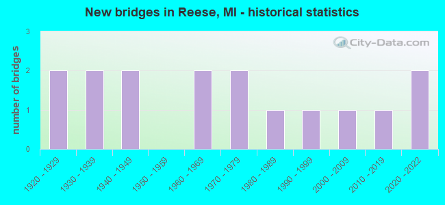
- New bridges - historical statistics
- 21920-1929
- 21930-1939
- 21940-1949
- 21960-1969
- 21970-1979
- 11980-1989
- 11990-1999
- 12000-2009
- 12010-2019
- 22020-2022


- Bridge Condition - Deck
- 8.3%Excellent
- 8.3%Very good
- 25.0%Good
- 33.3%Satisfactory
- 16.7%Fair
- 8.3%Serious

- Bridge Condition - Superstructure
- 8.3%Excellent
- 8.3%Very good
- 25.0%Good
- 8.3%Satisfactory
- 41.7%Fair
- 8.3%Poor

- Bridge Condition - Substructure
- 8.3%Excellent
- 41.7%Good
- 8.3%Satisfactory
- 25.0%Fair
- 16.7%Poor

- Bridge Condition - Channel
- 12.5%Very good
- 43.8%Good
- 18.8%Satisfactory
- 18.8%Fair
- 6.3%Poor

- Bridge Condition - Culverts
- 25.0%Excellent
- 25.0%Good
- 25.0%Satisfactory
- 25.0%Fair
Find on map >> Show street view
Structure Number: 732, Location: AT BRIGGS RD (Lat: 43.507850, Lng: -83.708886), Route carried "on" structure: County highway , Year Built: 1948, Status: Posted for load, Structure Length: 0.91m (2.99ft), Average Daily Traffic: 121 (year 2000), Truck Traffic: 10%, Average Future Daily Traffic: 145 (year 2020), Design Load: HS 20+Mod, Features Intersected: CONSTANT DURUSSEL DRAIN, Facility Carried by Structure: BROWN ROAD
Minimum Vertical Clearance: 30.48m (100.00ft), Kilometerpoint: 8.782, Lanes on structure: 2, Owner: County Highway Agency, Approaching Roadway Width: 7.9m (25.9ft), Material/Design: Steel, Design/Construction: Stringer/Multi-beam, Number Of Spans In Main Unit: 1, Length of Maximum Span: 8.2m (26.9ft), Curb-To-Curb Width: 9.1m (29.9ft), Out-to-Out Width: 9.9m (32.5ft)
Condition: Deck: Satisfactory, Superstructure: Satisfactory, Substructure: Fair, Channel: Satisfactory, Operating Rating: 12.7 metric tons, Method Used To Determine Operating Rating: Allowable Stress (AS), Inventory Rating: 4.5 metric tons, Method Used To Determine Inventory Rating: Allowable Stress (AS), Structural Evaluation: High priority of replacement, Deck Geometry: Equal to present minimum criteria, Waterway Adequacy: Equal to present minimum criteria, Approach Roadway Alignment: Equal to present desirable criteria, Bridge Posting: Required (Relationship of Operating Rating to Maximum Legal Load: 10.0 - 19.9% below), Length Of Structure Improvement: 1.40m (4.59ft), Designated Inspection Frequency: Every 24 months, Inspection Date: April 2020, Bridge Improvement Cost: $235,000, Roadway Improvement Cost: $70,000, Total Project Cost: $330,000, Deck Structure Type: Concrete Cast-file-Place, Wearing Surface/Protective System: Wearing Surface: Bituminous
Find on map >> Show street view
Structure Number: 735, Location: 200 FEET N OF BROWN ROAD (Lat: 43.509336, Lng: -83.738686), Route carried "on" structure: County highway , Year Built: 1924, Status: Posted for load, Structure Length: 1.00m (3.28ft), Average Daily Traffic: 96 (year 2000), Truck Traffic: 5%, Average Future Daily Traffic: 115 (year 2020), Design Load: H 15, Features Intersected: QUANICASSEE RIVER, Facility Carried by Structure: NOLET ROAD
Minimum Vertical Clearance: 30.48m (100.00ft), Kilometerpoint: 1.788, Lanes on structure: 2, Owner: County Highway Agency, Approaching Roadway Width: 8.5m (27.9ft), Skew: 4 degrees, Material/Design: Steel, Design/Construction: Stringer/Multi-beam, Number Of Spans In Main Unit: 1, Length of Maximum Span: 9.1m (29.9ft), Curb-To-Curb Width: 6.7m (22.0ft), Out-to-Out Width: 7.6m (24.9ft)
Condition: Deck: Serious, Superstructure: Poor, Substructure: Fair, Channel: Fair, Operating Rating: 40.9 metric tons, Method Used To Determine Operating Rating: Load Factor (LF), Inventory Rating: 24.5 metric tons, Method Used To Determine Inventory Rating: Load Factor (LF), Structural Evaluation: Meets minimum limits, Deck Geometry: Somewhat better than minimum adequacy, Waterway Adequacy: Better than present minimum criteria, Approach Roadway Alignment: Equal to present desirable criteria, Bridge Posting: Required (Relationship of Operating Rating to Maximum Legal Load: > 39.9% below), Length Of Structure Improvement: 1.50m (4.92ft), Designated Inspection Frequency: Every 12 months, Inspection Date: April 2021, Bridge Improvement Cost: $252,000, Roadway Improvement Cost: $70,000, Total Project Cost: $350,000, Deck Structure Type: Concrete Cast-file-Place, Wearing Surface/Protective System: Wearing Surface: Bituminous
Find on map >> Show street view
Structure Number: 9107, Location: 0.2 MI W OF M-15 (Lat: 43.450556, Lng: -83.758953), Route carried "on" structure: State highway 81, Year Built: 1939, Year Reconstructed: 1992, Status: Open, Structure Length: 1.52m (4.99ft), Average Daily Traffic: 8,033 (year 2007), Truck Traffic: 8%, Average Future Daily Traffic: 8,975 (year 2018), Design Load: HS 25 or greater, Features Intersected: CHEBOYGANING CREEK
Minimum Vertical Clearance: 30.48m (100.00ft), Kilometerpoint: 26.758, Lanes on structure: 2, Base Highway Network: Yes (Inventory Route: 47, Subroute: 10), Owner: State Highway Agency, Approaching Roadway Width: 13.4m (44.0ft), Material/Design: Prestressed concrete, Design/Construction: Box Beam or Girders - Multiple, Number Of Spans In Main Unit: 1, Length of Maximum Span: 15.2m (49.9ft), Curb-To-Curb Width: 13.4m (44.0ft), Out-to-Out Width: 14.3m (46.9ft)
Condition: Deck: Fair, Superstructure: Fair, Substructure: Fair, Channel: Satisfactory, Operating Rating: 82.3 metric tons, Method Used To Determine Operating Rating: Load Factor (LF) rating reported by rating factor (RF) method using MS18 loading, Inventory Rating: 49.2 metric tons, Method Used To Determine Inventory Rating: Load Factor (LF) rating reported by rating factor (RF) method using MS18 loading, Structural Evaluation: Somewhat better than minimum adequacy, Deck Geometry: Equal to present minimum criteria, Waterway Adequacy: Equal to present desirable criteria, Approach Roadway Alignment: Somewhat better than minimum adequacy, Designated Inspection Frequency: Every 24 months, Inspection Date: August 2021, Bridge Improvement Cost: $24,000, Deck Structure Type: Concrete Cast-file-Place, Wearing Surface/Protective System: Wearing Surface: Epoxy Overlay, Deck Protection: Epoxy Coated Reinforcing
Find on map >> Show street view
Structure Number: 9179, Location: 0.1 MI S OF M-15 (Lat: 43.426992, Lng: -83.738011), Route carried "on" structure: State highway 83, Year Built: 1941, Year Reconstructed: 1987, Status: Open, Structure Length: 1.98m (6.50ft), Average Daily Traffic: 2,975 (year 2007), Truck Traffic: 11%, Average Future Daily Traffic: 3,275 (year 2034), Design Load: HS 20+Mod, Features Intersected: CHEBOYGANING CREEK
Minimum Vertical Clearance: 30.48m (100.00ft), Kilometerpoint: 23.013, Lanes on structure: 2, Base Highway Network: Yes (Inventory Route: 46, Subroute: 7), Owner: State Highway Agency, Approaching Roadway Width: 12.2m (40.0ft), Skew: 4 degrees, Material/Design: Steel, Design/Construction: Stringer/Multi-beam, Number Of Spans In Main Unit: 1, Length of Maximum Span: 19.8m (65.0ft), Curb-To-Curb Width: 13.4m (44.0ft), Out-to-Out Width: 14.4m (47.2ft)
Condition: Deck: Good, Superstructure: Good, Substructure: Satisfactory, Channel: Good, Operating Rating: 61.6 metric tons, Method Used To Determine Operating Rating: Load Factor (LF) rating reported by rating factor (RF) method using MS18 loading, Inventory Rating: 36.9 metric tons, Method Used To Determine Inventory Rating: Load Factor (LF) rating reported by rating factor (RF) method using MS18 loading, Structural Evaluation: Equal to present minimum criteria, Deck Geometry: Better than present minimum criteria, Waterway Adequacy: Equal to present desirable criteria, Approach Roadway Alignment: Equal to present desirable criteria, Designated Inspection Frequency: Every 24 months, Inspection Date: July 2021, Deck Structure Type: Concrete Cast-file-Place, Wearing Surface/Protective System: Wearing Surface: Epoxy Overlay, Deck Protection: Epoxy Coated Reinforcing
Find on map >> Show street view
Structure Number: 9288, Location: 0.1 MI NE OF DEHMEL ROAD (Lat: 43.436317, Lng: -83.757328), Route carried "on" structure: ServiceCounty highway , Year Built: 1994, Status: Open, Structure Length: 1.82m (5.97ft), Average Daily Traffic: 609 (year 2010), Truck Traffic: 5%, Average Future Daily Traffic: 639 (year 2020), Design Load: HS 20, Features Intersected: CHEBOYGANING CREEK, Facility Carried by Structure: WADSWORTH ROAD
Minimum Vertical Clearance: 30.48m (100.00ft), Kilometerpoint: 12.816, Lanes on structure: 2, Owner: County Highway Agency, Approaching Roadway Width: 7.3m (24.0ft), Skew: 1 degrees, Material/Design: Prestressed concrete, Design/Construction: Box Beam or Girders - Multiple, Number Of Spans In Main Unit: 1, Length of Maximum Span: 17.6m (57.7ft), Curb-To-Curb Width: 9.8m (32.2ft), Out-to-Out Width: 10.4m (34.1ft)
Condition: Deck: Fair, Superstructure: Fair, Substructure: Good, Channel: Satisfactory, Operating Rating: 74.2 metric tons, Method Used To Determine Operating Rating: Load Factor (LF) rating reported by rating factor (RF) method using MS18 loading, Inventory Rating: 34.3 metric tons, Method Used To Determine Inventory Rating: Load Factor (LF) rating reported by rating factor (RF) method using MS18 loading, Structural Evaluation: Somewhat better than minimum adequacy, Deck Geometry: Equal to present minimum criteria, Waterway Adequacy: Equal to present desirable criteria, Approach Roadway Alignment: Equal to present desirable criteria, Designated Inspection Frequency: Every 24 months, Inspection Date: April 2021, Deck Structure Type: Concrete Cast-file-Place, Wearing Surface/Protective System: Wearing Surface: Integral Concrete, Deck Protection: Epoxy Coated Reinforcing
Find on map >> Show street view
Structure Number: 9294, Location: 1.0 MI N OF HOLLAND ROAD (Lat: 43.422486, Lng: -83.718189), Route carried "on" structure: ServiceCounty highway , Year Built: 1960, Status: Posted for load, Structure Length: 1.98m (6.50ft), Average Daily Traffic: 433 (year 2010), Truck Traffic: 5%, Average Future Daily Traffic: 455 (year 2020), Design Load: H 20, Features Intersected: CHEBOYGANING CREEK, Facility Carried by Structure: BLOCK ROAD
Minimum Vertical Clearance: 30.48m (100.00ft), Kilometerpoint: 3.307, Lanes on structure: 2, Owner: County Highway Agency, Approaching Roadway Width: 11.0m (36.1ft), Skew: 1 degrees, Material/Design: Steel, Design/Construction: Stringer/Multi-beam, Number Of Spans In Main Unit: 1, Length of Maximum Span: 18.6m (61.0ft), Curb-To-Curb Width: 7.0m (23.0ft), Out-to-Out Width: 8.0m (26.2ft)
Condition: Deck: Satisfactory, Superstructure: Fair, Substructure: Poor, Channel: Poor, Operating Rating: 35.6 metric tons, Method Used To Determine Operating Rating: Load Factor (LF) rating reported by rating factor (RF) method using MS18 loading, Inventory Rating: 21.4 metric tons, Method Used To Determine Inventory Rating: Load Factor (LF) rating reported by rating factor (RF) method using MS18 loading, Structural Evaluation: Meets minimum limits, Deck Geometry: Meets minimum limits, Waterway Adequacy: Equal to present desirable criteria, Approach Roadway Alignment: Equal to present desirable criteria, Bridge Posting: Required (Relationship of Operating Rating to Maximum Legal Load: > 39.9% below), Designated Inspection Frequency: Every 12 months, Inspection Date: April 2021, Deck Structure Type: Concrete Cast-file-Place, Wearing Surface/Protective System: Wearing Surface: Monolithic Concrete
Find on map >> Show street view
Structure Number: 10397, Location: 1.0 MI E OF BAY CO LINE (Lat: 43.522422, Lng: -83.681897), Route carried "on" structure: State highway 138, Year Built: 1968, Status: Open, Structure Length: 1.22m (4.00ft), Average Daily Traffic: 1,305 (year 2007), Truck Traffic: 6%, Average Future Daily Traffic: 2,112 (year 2018), Design Load: HS 20, Features Intersected: NO NAME DRAIN
Minimum Vertical Clearance: 30.48m (100.00ft), Kilometerpoint: 1.387, Lanes on structure: 2, Base Highway Network: Yes (Inventory Route: 27, Subroute: 6), Owner: State Highway Agency, Approaching Roadway Width: 12.8m (42.0ft), Material/Design: Steel, Design/Construction: Stringer/Multi-beam, Number Of Spans In Main Unit: 1, Length of Maximum Span: 12.2m (40.0ft), Curb or Sidewalk Widths: Left: 0.2m (0.7ft), Right: 0.2m (0.7ft), Curb-To-Curb Width: 12.5m (41.0ft), Out-to-Out Width: 13.3m (43.6ft)
Condition: Deck: Good, Superstructure: Fair, Substructure: Good, Channel: Good, Operating Rating: 80.4 metric tons, Method Used To Determine Operating Rating: Load Factor (LF) rating reported by rating factor (RF) method using MS18 loading, Inventory Rating: 48.0 metric tons, Method Used To Determine Inventory Rating: Load Factor (LF) rating reported by rating factor (RF) method using MS18 loading, Structural Evaluation: Somewhat better than minimum adequacy, Deck Geometry: Better than present minimum criteria, Waterway Adequacy: Equal to present desirable criteria, Approach Roadway Alignment: Equal to present desirable criteria, Designated Inspection Frequency: Every 24 months, Inspection Date: July 2020, Deck Structure Type: Concrete Cast-file-Place, Wearing Surface/Protective System: Wearing Surface: Epoxy Overlay
Find on map >> Show street view
Structure Number: 10411, Location: 0.6 MI SE OF SAGINAW COL (Lat: 43.414014, Lng: -83.688211), Route carried "on" structure: State highway 15, Year Built: 2009, Status: Open, Structure Length: 0.91m (2.99ft), Average Daily Traffic: 2,842 (year 2007), Truck Traffic: 5%, Average Future Daily Traffic: 3,600 (year 2030), Design Load: Greater than HL93, Features Intersected: SHEBOYGAN DRAIN
Minimum Vertical Clearance: 30.48m (100.00ft), Kilometerpoint: 27.587, Lanes on structure: 2, Base Highway Network: Yes (Inventory Route: 27, Subroute: 3), Owner: State Highway Agency, Approaching Roadway Width: 13.4m (44.0ft), Skew: 3 degrees, Material/Design: Prestressed concrete, Design/Construction: Stringer/Multi-beam, Number Of Spans In Main Unit: 1, Length of Maximum Span: 8.1m (26.6ft), Curb-To-Curb Width: 13.4m (44.0ft), Out-to-Out Width: 14.4m (47.2ft)
Condition: Deck: Very good, Superstructure: Very good, Substructure: Good, Channel: Good, Inventory Rating: 64.1 metric tons, Method Used To Determine Inventory Rating: Load Factor (LF), Structural Evaluation: Better than present minimum criteria, Deck Geometry: Better than present minimum criteria, Waterway Adequacy: Equal to present minimum criteria, Approach Roadway Alignment: Equal to present minimum criteria, Designated Inspection Frequency: Every 24 months, Inspection Date: October 2020, Deck Structure Type: Concrete Cast-file-Place, Wearing Surface/Protective System: Wearing Surface: Bituminous, Deck Protection: Epoxy Coated Reinforcing
Find on map >> Show street view
Structure Number: 10412, Location: @ SAGINAW COUNTY LINE (Lat: 43.418553, Lng: -83.698497), Route carried "on" structure: State highway 15, Year Built: 1929, Status: Open, Structure Length: 0.94m (3.08ft), Average Daily Traffic: 2,842 (year 2007), Truck Traffic: 7%, Average Future Daily Traffic: 4,100 (year 2018), Design Load: H 15, Features Intersected: CHEBOYGANING CREEK
Minimum Vertical Clearance: 30.48m (100.00ft), Kilometerpoint: 0.000, Lanes on structure: 2, Base Highway Network: Yes (Inventory Route: 46, Subroute: 3), Owner: State Highway Agency, Approaching Roadway Width: 11.6m (38.1ft), Material/Design: Concrete, Design/Construction: Tee Beam, Number Of Spans In Main Unit: 1, Length of Maximum Span: 9.4m (30.8ft), Curb-To-Curb Width: 14.0m (45.9ft), Out-to-Out Width: 14.7m (48.2ft)
Condition: Deck: Satisfactory, Superstructure: Fair, Substructure: Poor, Channel: Fair, Operating Rating: 58.3 metric tons, Method Used To Determine Operating Rating: Load Factor (LF) rating reported by rating factor (RF) method using MS18 loading, Inventory Rating: 35.0 metric tons, Method Used To Determine Inventory Rating: Load Factor (LF) rating reported by rating factor (RF) method using MS18 loading, Structural Evaluation: Meets minimum limits, Deck Geometry: Superior to present desirable criteria, Waterway Adequacy: Equal to present desirable criteria, Approach Roadway Alignment: Equal to present desirable criteria, Designated Inspection Frequency: Every 24 months, Other Special Inspection Frequency: Every 12 months, Inspection Date: August 2020, Other Special Inspection Date: August 2021, Deck Structure Type: Concrete Cast-file-Place, Wearing Surface/Protective System: Wearing Surface: Bituminous
Find on map >> Show street view
Structure Number: 10416, Location: 0.3 MI WEST OF RICHVILLE (Lat: 43.407239, Lng: -83.679006), Route carried "on" structure: State highway 46, Year Built: 1939, Status: Open, Structure Length: 0.68m (2.23ft), Average Daily Traffic: 6,701 (year 2007), Truck Traffic: 10%, Average Future Daily Traffic: 7,308 (year 2018), Features Intersected: CHEBOYGAN & BRANCHES DRN
Minimum Vertical Clearance: 30.48m (100.00ft), Kilometerpoint: 1.577, Lanes on structure: 2, Base Highway Network: Yes (Inventory Route: 27, Subroute: 8), Owner: State Highway Agency, Approaching Roadway Width: 10.9m (35.8ft), Skew: 6 degrees, Material/Design: Concrete, Design/Construction: Culvert, Number Of Spans In Main Unit: 1, Length of Maximum Span: 6.8m (22.3ft), Out-to-Out Width: 21.9m (71.9ft)
Condition: Channel: Fair, Culverts: Fair, Operating Rating: 40.8 metric tons, Method Used To Determine Operating Rating: Field evaluation and documented engineering judgment, Inventory Rating: 24.5 metric tons, Method Used To Determine Inventory Rating: Field evaluation and documented engineering judgment, Structural Evaluation: Somewhat better than minimum adequacy, Waterway Adequacy: Equal to present minimum criteria, Approach Roadway Alignment: Equal to present minimum criteria, Designated Inspection Frequency: Every 12 months, Inspection Date: March 2021
Find on map >> Show street view
Structure Number: 10488, Location: SEC 29-30 DENMARK TWP (Lat: 43.407900, Lng: -83.679600), Route carried "on" structure: County highway 7903, Year Built: 2020, Status: Open, Structure Length: 0.98m (3.22ft), Average Daily Traffic: 2,348 (year 2017), Truck Traffic: 10%, Average Future Daily Traffic: 6,230 (year 2037), Design Load: Greater than HL93, Features Intersected: SHEBOYGAN 1/C DRAIN, Facility Carried by Structure: VAN BUREN ROAD
Minimum Vertical Clearance: 30.48m (100.00ft), Kilometerpoint: 10.188, Lanes on structure: 2, Owner: County Highway Agency, Approaching Roadway Width: 8.5m (27.9ft), Skew: 1 degrees, Material/Design: Prestressed concrete, Design/Construction: Box Beam or Girders - Single/Spread, Number Of Spans In Main Unit: 1, Length of Maximum Span: 9.4m (30.8ft), Curb-To-Curb Width: 8.5m (27.9ft), Out-to-Out Width: 9.3m (30.5ft)
Condition: Deck: Excellent, Superstructure: Excellent, Substructure: Excellent, Channel: Very good, Operating Rating: 65.4 metric tons, Method Used To Determine Operating Rating: Load and Resistance Factor Rating (LRFR) rating reported by rating factor(RF) method using HL-93 loadings, Inventory Rating: 48.0 metric tons, Method Used To Determine Inventory Rating: Load and Resistance Factor Rating (LRFR) rating reported by rating factor(RF) method using HL-93 loadings, Structural Evaluation: Superior to present desirable criteria, Deck Geometry: Meets minimum limits, Waterway Adequacy: Equal to present minimum criteria, Approach Roadway Alignment: Equal to present desirable criteria, Length Of Structure Improvement: 1.37m (4.49ft), Designated Inspection Frequency: Every 24 months, Inspection Date: July 2020, Bridge Improvement Cost: $444,000, Roadway Improvement Cost: $178,000, Total Project Cost: $728,000, Deck Structure Type: Concrete Cast-file-Place, Wearing Surface/Protective System: Wearing Surface: Monolithic Concrete, Deck Protection: Epoxy Coated Reinforcing
Find on map >> Show street view
Structure Number: 10492, Location: SEC 2-3 DENMARK TWP (Lat: 43.472397, Lng: -83.621436), Route carried "on" structure: County highway , Year Built: 1972, Status: Open, Structure Length: 0.76m (2.49ft), Average Daily Traffic: 2,000 (year 2009), Average Future Daily Traffic: 3,600 (year 2029), Design Load: HS 20, Features Intersected: NORTHWEST DRAIN, Facility Carried by Structure: BRADLEYVILLE ROAD
Minimum Vertical Clearance: 30.48m (100.00ft), Kilometerpoint: 8.807, Lanes on structure: 2, Owner: County Highway Agency, Approaching Roadway Width: 9.1m (29.9ft), Skew: 2 degrees, Material/Design: Prestressed concrete, Design/Construction: Box Beam or Girders - Multiple, Number Of Spans In Main Unit: 1, Length of Maximum Span: 7.2m (23.6ft), Curb-To-Curb Width: 10.7m (35.1ft), Out-to-Out Width: 11.1m (36.4ft)
Condition: Deck: Satisfactory, Superstructure: Good, Substructure: Good, Channel: Good, Operating Rating: 95.4 metric tons, Method Used To Determine Operating Rating: Field evaluation and documented engineering judgment, Inventory Rating: 57.2 metric tons, Method Used To Determine Inventory Rating: Field evaluation and documented engineering judgment, Structural Evaluation: Better than present minimum criteria, Deck Geometry: Equal to present minimum criteria, Waterway Adequacy: Equal to present desirable criteria, Approach Roadway Alignment: Superior to present desirable criteria, Designated Inspection Frequency: Every 24 months, Inspection Date: April 2021, Deck Structure Type: Concrete Precast Panels, Wearing Surface/Protective System: Wearing Surface: Bituminous
Find on map >> Show street view
Structure Number: 10595, Location: SEC 19 GILFORD TWP (Lat: 43.515217, Lng: -83.698853), Route carried "on" structure: ServiceCounty highway , Year Built: 1979, Status: Open, Structure Length: 0.66m (2.17ft), Average Daily Traffic: 43 (year 2009), Average Future Daily Traffic: 78 (year 2029), Design Load: H 20, Features Intersected: GIBSON DRAIN, Facility Carried by Structure: PARRENT ROAD
Minimum Vertical Clearance: 30.48m (100.00ft), Kilometerpoint: 0.016, Lanes on structure: 2, Owner: County Highway Agency, Approaching Roadway Width: 9.1m (29.9ft), Material/Design: Steel, Design/Construction: Culvert, Number Of Spans In Main Unit: 1, Length of Maximum Span: 6.5m (21.3ft)
Condition: Channel: Good, Culverts: Satisfactory, Operating Rating: 31.4 metric tons, Method Used To Determine Operating Rating: Load Factor (LF) rating reported by rating factor (RF) method using MS18 loading, Inventory Rating: 18.8 metric tons, Method Used To Determine Inventory Rating: Load Factor (LF) rating reported by rating factor (RF) method using MS18 loading, Structural Evaluation: Somewhat better than minimum adequacy, Waterway Adequacy: Equal to present desirable criteria, Approach Roadway Alignment: Equal to present minimum criteria, Designated Inspection Frequency: Every 24 months, Inspection Date: May 2021
Find on map >> Show street view
Structure Number: 106, Location: SEC 31-32 GILFORD TWP (Lat: 43.480592, Lng: -83.681233), Route carried "on" structure: ServiceCounty highway , Year Built: 1980, Status: Open, Structure Length: 0.68m (2.23ft), Average Daily Traffic: 450 (year 2009), Average Future Daily Traffic: 815 (year 2029), Design Load: H 20, Features Intersected: BR 1 SQUAW CK-GILFORD DN, Facility Carried by Structure: VAN BUREN ROAD
Minimum Vertical Clearance: 30.48m (100.00ft), Kilometerpoint: 17.222, Lanes on structure: 2, Owner: County Highway Agency, Approaching Roadway Width: 8.5m (27.9ft), Material/Design: Steel, Design/Construction: Culvert, Number Of Spans In Main Unit: 1, Length of Maximum Span: 6.8m (22.3ft)
Condition: Channel: Good, Culverts: Good, Operating Rating: 52.5 metric tons, Method Used To Determine Operating Rating: Load Factor (LF) rating reported by rating factor (RF) method using MS18 loading, Inventory Rating: 39.2 metric tons, Method Used To Determine Inventory Rating: Load Factor (LF) rating reported by rating factor (RF) method using MS18 loading, Structural Evaluation: Better than present minimum criteria, Waterway Adequacy: Better than present minimum criteria, Approach Roadway Alignment: Equal to present desirable criteria, Designated Inspection Frequency: Every 24 months, Inspection Date: May 2021
Find on map >> Show street view
Structure Number: 10602, Location: SEC 20 GILFORD TWP (Lat: 43.522369, Lng: -83.672111), Route carried "on" structure: ServiceCounty highway , Year Built: 2020, Status: Open, Structure Length: 0.67m (2.20ft), Average Daily Traffic: 24 (year 2009), Average Future Daily Traffic: 45 (year 2029), Design Load: Greater than HL93, Features Intersected: CENTER LINE DRAIN, Facility Carried by Structure: PIKE ROAD
Minimum Vertical Clearance: 30.48m (100.00ft), Kilometerpoint: 0.798, Lanes on structure: 2, Owner: County Highway Agency, Approaching Roadway Width: 8.5m (27.9ft), Material/Design: Concrete, Design/Construction: Culvert, Number Of Spans In Main Unit: 1, Length of Maximum Span: 6.1m (20.0ft)
Condition: Channel: Very good, Culverts: Excellent, Operating Rating: 69.3 metric tons, Method Used To Determine Operating Rating: Load and Resistance Factor Rating (LRFR) rating reported by rating factor(RF) method using HL-93 loadings, Inventory Rating: 53.5 metric tons, Method Used To Determine Inventory Rating: Load and Resistance Factor Rating (LRFR) rating reported by rating factor(RF) method using HL-93 loadings, Structural Evaluation: Superior to present desirable criteria, Waterway Adequacy: Superior to present desirable criteria, Approach Roadway Alignment: Better than present minimum criteria, Designated Inspection Frequency: Every 24 months, Inspection Date: Febuary 2021
Find on map >> Show street view
Structure Number: 13688, Location: 50 FT EAST OF BRIGGS RD (Lat: 43.493428, Lng: -83.708708), Route carried "on" structure: County highway , Year Built: 2011, Status: Open, Structure Length: 1.34m (4.40ft), Average Daily Traffic: 160 (year 2011), Truck Traffic: 1%, Average Future Daily Traffic: 200 (year 2031), Design Load: HL 93, Features Intersected: CONSTANT DURUSSELL DRAIN, Facility Carried by Structure: KINNEY ROAD
Minimum Vertical Clearance: 30.48m (100.00ft), Kilometerpoint: 8.807, Lanes on structure: 2, Owner: County Highway Agency, Approaching Roadway Width: 9.8m (32.2ft), Material/Design: Wood or Timber, Design/Construction: Slab, Number Of Spans In Main Unit: 3, Length of Maximum Span: 6.1m (20.0ft), Curb-To-Curb Width: 9.8m (32.2ft), Out-to-Out Width: 10.4m (34.1ft)
Condition: Deck: Good, Superstructure: Good, Substructure: Good, Channel: Good, Operating Rating: 50.2 metric tons, Method Used To Determine Operating Rating: Load Factor (LF) rating reported by rating factor (RF) method using MS18 loading, Inventory Rating: 38.6 metric tons, Method Used To Determine Inventory Rating: Load Factor (LF) rating reported by rating factor (RF) method using MS18 loading, Structural Evaluation: Better than present minimum criteria, Deck Geometry: Better than present minimum criteria, Waterway Adequacy: Equal to present desirable criteria, Approach Roadway Alignment: Equal to present desirable criteria, Designated Inspection Frequency: Every 24 months, Inspection Date: April 2020, Deck Structure Type: Wood or Timber, Wearing Surface/Protective System: Wearing Surface: Bituminous