Bridge Statistics for Reedsville, Pennsylvania (PA)
Condition, Traffic, Stress, Structural Evaluation, Project Costs
- National Bridge Inventory (NBI) Statistics
- 19Number of bridges
- 384ft / 117mTotal length
- $15,306,000Total costs
- 117,788Total average daily traffic
- 15,840Total average daily truck traffic
- National Bridge Inventory (NBI) Registered Bridges for Reedsville
- No street view available for this location
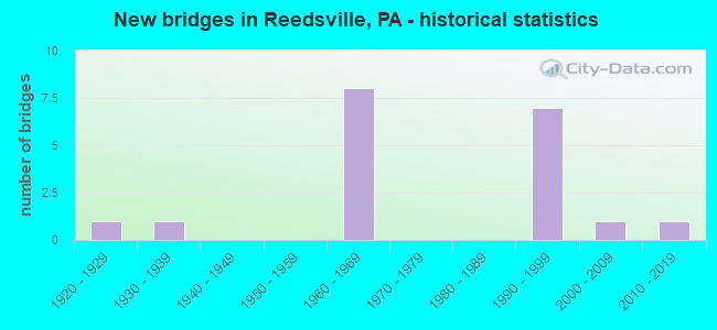
- New bridges - historical statistics
- 11920-1929
- 11930-1939
- 81960-1969
- 71990-1999
- 12000-2009
- 12010-2019


- Bridge Condition - Deck
- 7.7%Very good
- 23.1%Good
- 53.8%Satisfactory
- 15.4%Fair

- Bridge Condition - Superstructure
- 7.7%Very good
- 23.1%Good
- 61.5%Satisfactory
- 7.7%Fair

- Bridge Condition - Substructure
- 38.5%Good
- 46.2%Satisfactory
- 15.4%Fair

- Bridge Condition - Channel
- 27.3%Very good
- 18.2%Good
- 45.5%Satisfactory
- 9.1%Fair
Find on map >> Show street view
Structure Number: 26427, Location: REEDSVILLE (Lat: 40.662194, Lng: -77.598894), Route carried "on" structure: US 322, Year Built: 1964, Status: Open, Structure Length: 10.09m (33.10ft), Average Daily Traffic: 10,629 (year 2020), Truck Traffic: 16%, Average Future Daily Traffic: 14,593 (year 2040), Design Load: HS 20, Features Intersected: KISH CR & TWP RD 439
Minimum Vertical Clearance: 30+ m (98+ ft), Kilometerpoint: 13.671, Lanes on structure: 2, Lanes under structure: 2, Base Highway Network: Yes, Owner: State Highway Agency, Approaching Roadway Width: 12.2m (40.0ft), Skew: 1 degrees, Material/Design: Steel continuous, Design/Construction: Stringer/Multi-beam, Number Of Spans In Main Unit: 4, Length of Maximum Span: 25.9m (85.0ft), Curb-To-Curb Width: 11.0m (36.1ft), Out-to-Out Width: 12.4m (40.7ft)
Condition: Deck: Satisfactory, Superstructure: Satisfactory, Substructure: Satisfactory, Channel: Very good, Operating Rating: 50.8 metric tons, Method Used To Determine Operating Rating: Load Factor (LF), Inventory Rating: 30.8 metric tons, Method Used To Determine Inventory Rating: Load Factor (LF), Structural Evaluation: Equal to present minimum criteria, Deck Geometry: Somewhat better than minimum adequacy, Underclear: Superior to present desirable criteria, Waterway Adequacy: Superior to present desirable criteria, Approach Roadway Alignment: Equal to present desirable criteria, Length Of Structure Improvement: 10.10m (33.14ft), Designated Inspection Frequency: Every 24 months, Inspection Date: April 2020, Bridge Improvement Cost: $145,000, Roadway Improvement Cost: $426,000, Total Project Cost: $1,954,000, Deck Structure Type: Concrete Cast-file-Place, Wearing Surface/Protective System: Wearing Surface: Latex Concrete
Find on map >> Show street view
Structure Number: 26428, Location: REEDSVILLE (Lat: 40.662342, Lng: -77.598839), Route carried "on" structure: US 322, Year Built: 1964, Status: Open, Structure Length: 10.09m (33.10ft), Average Daily Traffic: 10,535 (year 2020), Truck Traffic: 16%, Average Future Daily Traffic: 15,483 (year 2040), Design Load: HS 20, Features Intersected: KISH CR & TWP RD 439
Minimum Vertical Clearance: 30+ m (98+ ft), Kilometerpoint: 13.662, Lanes on structure: 2, Lanes under structure: 2, Base Highway Network: Yes, Owner: State Highway Agency, Approaching Roadway Width: 14.6m (47.9ft), Skew: 1 degrees, Material/Design: Steel continuous, Design/Construction: Stringer/Multi-beam, Number Of Spans In Main Unit: 4, Length of Maximum Span: 25.9m (85.0ft), Curb or Sidewalk Widths: Left: 0.5m (1.6ft), Right: 0.5m (1.6ft), Curb-To-Curb Width: 11.3m (37.1ft), Out-to-Out Width: 12.4m (40.7ft)
Condition: Deck: Satisfactory, Superstructure: Satisfactory, Substructure: Satisfactory, Channel: Very good, Operating Rating: 50.8 metric tons, Method Used To Determine Operating Rating: Load Factor (LF), Inventory Rating: 30.8 metric tons, Method Used To Determine Inventory Rating: Load Factor (LF), Structural Evaluation: Equal to present minimum criteria, Deck Geometry: Somewhat better than minimum adequacy, Underclear: Superior to present desirable criteria, Waterway Adequacy: Superior to present desirable criteria, Approach Roadway Alignment: Equal to present desirable criteria, Length Of Structure Improvement: 10.10m (33.14ft), Designated Inspection Frequency: Every 24 months, Inspection Date: April 2020, Bridge Improvement Cost: $145,000, Roadway Improvement Cost: $426,000, Total Project Cost: $1,954,000, Deck Structure Type: Concrete Cast-file-Place, Wearing Surface/Protective System: Wearing Surface: Latex Concrete
Find on map >> Show street view
Structure Number: 26429, Location: REEDSVILLE (Lat: 40.656067, Lng: -77.592456), Route carried "on" structure: US 322, Year Built: 1964, Status: Open, Structure Length: 16.00m (52.49ft), Average Daily Traffic: 10,629 (year 2020), Truck Traffic: 16%, Average Future Daily Traffic: 14,593 (year 2040), Design Load: HS 20, Features Intersected: KISHACOQUILLAS C/ABND RR
Minimum Vertical Clearance: 30+ m (98+ ft), Kilometerpoint: 14.523, Lanes on structure: 2, Base Highway Network: Yes, Owner: State Highway Agency, Approaching Roadway Width: 9.8m (32.2ft), Skew: 5 degrees, Material/Design: Steel, Design/Construction: Stringer/Multi-beam, Number Of Spans In Main Unit: 5, Length of Maximum Span: 31.7m (104.0ft), Curb-To-Curb Width: 8.9m (29.2ft), Out-to-Out Width: 10.0m (32.8ft)
Condition: Deck: Satisfactory, Superstructure: Satisfactory, Substructure: Satisfactory, Channel: Satisfactory, Inventory Rating: 62.6 metric tons, Method Used To Determine Inventory Rating: Load Factor (LF), Structural Evaluation: Equal to present minimum criteria, Deck Geometry: Meets minimum limits, Underclear: High priority of corrective action, Waterway Adequacy: Superior to present desirable criteria, Approach Roadway Alignment: Equal to present desirable criteria, Length Of Structure Improvement: 16.00m (52.49ft), Designated Inspection Frequency: Every 24 months, Inspection Date: April 2020, Bridge Improvement Cost: $207,000, Roadway Improvement Cost: $610,000, Total Project Cost: $2,796,000, Deck Structure Type: Concrete Cast-file-Place, Wearing Surface/Protective System: Wearing Surface: Latex Concrete
Find on map >> Show street view
Structure Number: 2643, Location: 1 MI S REEDSVILLE (Lat: 40.654694, Lng: -77.585028), Route carried "on" structure: US 322, Year Built: 1964, Status: Open, Structure Length: 17.53m (57.51ft), Average Daily Traffic: 10,629 (year 2020), Truck Traffic: 16%, Average Future Daily Traffic: 14,593 (year 2040), Design Load: HS 20, Features Intersected: KISHACOQUILLAS C/ABND RR
Minimum Vertical Clearance: 30+ m (98+ ft), Kilometerpoint: 14.523, Lanes on structure: 2, Base Highway Network: Yes, Owner: State Highway Agency, Approaching Roadway Width: 9.8m (32.2ft), Skew: 19 degrees, Material/Design: Steel, Design/Construction: Stringer/Multi-beam, Number Of Spans In Main Unit: 5, Length of Maximum Span: 33.5m (109.9ft), Curb-To-Curb Width: 9.2m (30.2ft), Out-to-Out Width: 10.0m (32.8ft)
Condition: Deck: Satisfactory, Superstructure: Satisfactory, Substructure: Satisfactory, Channel: Fair, Operating Rating: 89.8 metric tons, Method Used To Determine Operating Rating: Load Factor (LF), Inventory Rating: 53.5 metric tons, Method Used To Determine Inventory Rating: Load Factor (LF), Structural Evaluation: Equal to present minimum criteria, Deck Geometry: Meets minimum limits, Underclear: High priority of corrective action, Waterway Adequacy: Superior to present desirable criteria, Approach Roadway Alignment: Equal to present desirable criteria, Length Of Structure Improvement: 17.50m (57.41ft), Designated Inspection Frequency: Every 24 months, Underwater Inspection Frequency: Every 24 months, Inspection Date: June 2020, Underwater Inspection Date: July 2021, Bridge Improvement Cost: $190,000, Roadway Improvement Cost: $558,000, Total Project Cost: $2,559,000, Deck Structure Type: Concrete Cast-file-Place, Wearing Surface/Protective System: Wearing Surface: Latex Concrete
Find on map >> Show street view
Structure Number: 26431, Location: REEDSVILLE (Lat: 40.656219, Lng: -77.592592), Route carried "on" structure: US 322, Year Built: 1964, Status: Open, Structure Length: 16.00m (52.49ft), Average Daily Traffic: 10,535 (year 2020), Truck Traffic: 16%, Average Future Daily Traffic: 15,483 (year 2041), Design Load: HS 20, Features Intersected: KISHACOQUILLAS C/ABND RR
Minimum Vertical Clearance: 30+ m (98+ ft), Kilometerpoint: 14.499, Lanes on structure: 2, Base Highway Network: Yes, Owner: State Highway Agency, Approaching Roadway Width: 9.8m (32.2ft), Skew: 5 degrees, Material/Design: Steel, Design/Construction: Stringer/Multi-beam, Number Of Spans In Main Unit: 5, Length of Maximum Span: 31.7m (104.0ft), Curb or Sidewalk Widths: Left: 0.5m (1.6ft), Right: 0.5m (1.6ft), Curb-To-Curb Width: 9.1m (29.9ft), Out-to-Out Width: 10.0m (32.8ft)
Condition: Deck: Satisfactory, Superstructure: Satisfactory, Substructure: Good, Channel: Satisfactory, Inventory Rating: 63.5 metric tons, Method Used To Determine Inventory Rating: Load Factor (LF), Structural Evaluation: Equal to present minimum criteria, Deck Geometry: Meets minimum limits, Underclear: High priority of corrective action, Waterway Adequacy: Superior to present desirable criteria, Approach Roadway Alignment: Equal to present desirable criteria, Length Of Structure Improvement: 16.00m (52.49ft), Designated Inspection Frequency: Every 24 months, Underwater Inspection Frequency: Every 60 months, Inspection Date: April 2020, Underwater Inspection Date: July 2021, Bridge Improvement Cost: $207,000, Roadway Improvement Cost: $610,000, Total Project Cost: $2,796,000, Deck Structure Type: Concrete Cast-file-Place, Wearing Surface/Protective System: Wearing Surface: Latex Concrete
Find on map >> Show street view
Structure Number: 26432, Location: 1 MI S REEDSVILLE (Lat: 40.654794, Lng: -77.585017), Route carried "on" structure: US 322, Year Built: 1964, Status: Open, Structure Length: 17.53m (57.51ft), Average Daily Traffic: 10,535 (year 2020), Truck Traffic: 16%, Average Future Daily Traffic: 15,483 (year 2040), Design Load: HS 20, Features Intersected: KISHACOQUILLAS C/ABND RR
Minimum Vertical Clearance: 30+ m (98+ ft), Kilometerpoint: 14.499, Lanes on structure: 2, Base Highway Network: Yes, Owner: State Highway Agency, Approaching Roadway Width: 9.8m (32.2ft), Skew: 5 degrees, Material/Design: Steel, Design/Construction: Stringer/Multi-beam, Number Of Spans In Main Unit: 5, Length of Maximum Span: 33.5m (109.9ft), Curb or Sidewalk Widths: Left: 0.5m (1.6ft), Right: 0.5m (1.6ft), Curb-To-Curb Width: 9.1m (29.9ft), Out-to-Out Width: 10.0m (32.8ft)
Condition: Deck: Satisfactory, Superstructure: Satisfactory, Substructure: Satisfactory, Channel: Satisfactory, Operating Rating: 88.9 metric tons, Method Used To Determine Operating Rating: Load Factor (LF), Inventory Rating: 53.5 metric tons, Method Used To Determine Inventory Rating: Load Factor (LF), Structural Evaluation: Equal to present minimum criteria, Deck Geometry: Meets minimum limits, Underclear: High priority of corrective action, Waterway Adequacy: Superior to present desirable criteria, Approach Roadway Alignment: Equal to present desirable criteria, Length Of Structure Improvement: 17.50m (57.41ft), Designated Inspection Frequency: Every 24 months, Inspection Date: June 2020, Bridge Improvement Cost: $190,000, Roadway Improvement Cost: $558,000, Total Project Cost: $2,559,000, Deck Structure Type: Concrete Cast-file-Place, Wearing Surface/Protective System: Wearing Surface: Latex Concrete
Find on map >> Show street view
Structure Number: 26502, Location: REEDSVILLE (Lat: 40.662344, Lng: -77.594650), Route carried "on" structure: State highway , Year Built: 1921, Year Reconstructed: 1939, Status: Open, Structure Length: 2.59m (8.50ft), Average Daily Traffic: 6,266 (year 2020), Truck Traffic: 3%, Average Future Daily Traffic: 8,771 (year 2040), Design Load: H 15, Features Intersected: HONEY CREEK, Facility Carried by Structure: SR 1005
Minimum Vertical Clearance: 30+ m (98+ ft), Kilometerpoint: 9.265, Lanes on structure: 2, Owner: State Highway Agency, Approaching Roadway Width: 10.4m (34.1ft), Material/Design: Concrete, Design/Construction: Tee Beam, Number Of Spans In Main Unit: 2, Length of Maximum Span: 10.4m (34.1ft), Curb or Sidewalk Widths: Left: 0.2m (0.7ft), Right: 1.5m (4.9ft), Curb-To-Curb Width: 10.5m (34.4ft), Out-to-Out Width: 12.6m (41.3ft)
Condition: Deck: Fair, Superstructure: Fair, Substructure: Fair, Channel: Satisfactory, Operating Rating: 68.0 metric tons, Method Used To Determine Operating Rating: Field evaluation and documented engineering judgment, Inventory Rating: 40.8 metric tons, Method Used To Determine Inventory Rating: Field evaluation and documented engineering judgment, Structural Evaluation: Somewhat better than minimum adequacy, Deck Geometry: Meets minimum limits, Waterway Adequacy: Equal to present minimum criteria, Approach Roadway Alignment: Equal to present desirable criteria, Length Of Structure Improvement: 2.60m (8.53ft), Designated Inspection Frequency: Every 24 months, Inspection Date: October 2020, Bridge Improvement Cost: $50,000, Roadway Improvement Cost: $250,000, Total Project Cost: $675,000, Deck Structure Type: Concrete Cast-file-Place, Wearing Surface/Protective System: Wearing Surface: Bituminous
Find on map >> Show street view
Structure Number: 26614, Location: 400FT W INTER T439-LR29 (Lat: 40.663003, Lng: -77.597300), Route carried "on" structure: City street , Year Built: 1930, Status: Open, Structure Length: 1.22m (4.00ft), Average Daily Traffic: 800 (year 2021), Truck Traffic: 1%, Average Future Daily Traffic: 1,200 (year 2041), Design Load: HS 20, Features Intersected: TEA CREEK, Facility Carried by Structure: T-439
Minimum Vertical Clearance: 30+ m (98+ ft), Kilometerpoint: 0.000, Lanes on structure: 2, Owner: Town or Township Highway Agency, Approaching Roadway Width: 5.8m (19.0ft), Skew: 3 degrees, Material/Design: Steel, Design/Construction: Stringer/Multi-beam, Number Of Spans In Main Unit: 1, Length of Maximum Span: 11.6m (38.1ft), Curb or Sidewalk Widths: Left: 1.3m (4.3ft), Right: 0.1m (0.3ft), Curb-To-Curb Width: 5.9m (19.4ft), Out-to-Out Width: 7.7m (25.3ft)
Condition: Deck: Fair, Superstructure: Satisfactory, Substructure: Fair, Channel: Satisfactory, Operating Rating: 51.7 metric tons, Method Used To Determine Operating Rating: Load Factor (LF), Inventory Rating: 30.8 metric tons, Method Used To Determine Inventory Rating: Load Factor (LF), Structural Evaluation: Somewhat better than minimum adequacy, Deck Geometry: High priority of replacement, Waterway Adequacy: Better than present minimum criteria, Approach Roadway Alignment: Equal to present desirable criteria, Length Of Structure Improvement: 1.20m (3.94ft), Designated Inspection Frequency: Every 24 months, Inspection Date: April 2021, Bridge Improvement Cost: $2,000, Total Project Cost: $13,000, Deck Structure Type: Concrete Cast-file-Place, Wearing Surface/Protective System: Wearing Surface: Bituminous
Find on map >> Show street view
Structure Number: 26615, Location: 50FT N INTER LR499 &T445 (Lat: 40.665739, Lng: -77.592744), Route carried "on" structure: City street , Year Built: 1993, Status: Open, Structure Length: 2.65m (8.69ft), Average Daily Traffic: 150 (year 2021), Truck Traffic: 5%, Average Future Daily Traffic: 210 (year 2041), Design Load: HS 20+Mod, Features Intersected: HONEY CREEK, Facility Carried by Structure: T-446
Minimum Vertical Clearance: 30+ m (98+ ft), Kilometerpoint: 0.000, Lanes on structure: 1, Owner: Town or Township Highway Agency, Approaching Roadway Width: 4.3m (14.1ft), Skew: 2 degrees, Material/Design: Prestressed concrete, Design/Construction: Box Beam or Girders - Multiple, Number Of Spans In Main Unit: 1, Length of Maximum Span: 26.2m (86.0ft), Curb or Sidewalk Widths: Left: 0.0m, Right: 1.5m (4.9ft), Curb-To-Curb Width: 4.3m (14.1ft), Out-to-Out Width: 6.6m (21.7ft)
Condition: Deck: Satisfactory, Superstructure: Satisfactory, Substructure: Satisfactory, Channel: Good, Inventory Rating: 44.5 metric tons, Method Used To Determine Inventory Rating: Load Factor (LF), Structural Evaluation: Equal to present minimum criteria, Deck Geometry: High priority of replacement, Waterway Adequacy: Equal to present desirable criteria, Approach Roadway Alignment: Equal to present minimum criteria, Length Of Structure Improvement: 3.40m (11.15ft), Designated Inspection Frequency: Every 24 months, Inspection Date: June 2021, Deck Structure Type: Concrete Cast-file-Place, Wearing Surface/Protective System: Wearing Surface: Monolithic Concrete, Deck Protection: Epoxy Coated Reinforcing
Find on map >> Show street view
Structure Number: 40248, Location: REEDSVILLE (Lat: 40.667922, Lng: -77.603842), Route carried "on" structure: US 322, Year Built: 1998, Status: Open, Structure Length: 3.41m (11.19ft), Average Daily Traffic: 10,629 (year 2020), Truck Traffic: 16%, Average Future Daily Traffic: 14,593 (year 2041), Design Load: HS 25 or greater, Features Intersected: SR 655-PA 655
Minimum Vertical Clearance: 30+ m (98+ ft), Kilometerpoint: 12.942, Lanes on structure: 2, Lanes under structure: 8, Base Highway Network: Yes, Owner: State Highway Agency, Approaching Roadway Width: 13.1m (43.0ft), Skew: 12 degrees, Material/Design: Prestressed concrete, Design/Construction: Stringer/Multi-beam, Number Of Spans In Main Unit: 1, Length of Maximum Span: 32.3m (106.0ft), Curb or Sidewalk Widths: Left: 0.2m (0.7ft), Right: 0.2m (0.7ft), Curb-To-Curb Width: 13.1m (43.0ft), Out-to-Out Width: 14.0m (45.9ft)
Condition: Deck: Good, Superstructure: Good, Substructure: Good, Inventory Rating: 45.4 metric tons, Method Used To Determine Inventory Rating: Load Factor (LF), Structural Evaluation: Better than present minimum criteria, Deck Geometry: Superior to present desirable criteria, Underclear: Equal to present minimum criteria, Approach Roadway Alignment: Equal to present desirable criteria, Length Of Structure Improvement: 4.40m (14.44ft), Designated Inspection Frequency: Every 24 months, Inspection Date: October 2021, Deck Structure Type: Concrete Cast-file-Place, Wearing Surface/Protective System: Wearing Surface: Monolithic Concrete, Deck Protection: Epoxy Coated Reinforcing
Find on map >> Show street view
Structure Number: 40249, Location: REEDSVILLE (Lat: 40.668047, Lng: -77.603750), Route carried "on" structure: US 322, Year Built: 1998, Status: Open, Structure Length: 3.57m (11.71ft), Average Daily Traffic: 10,535 (year 2020), Truck Traffic: 16%, Average Future Daily Traffic: 15,483 (year 2039), Design Load: HS 25 or greater, Features Intersected: SR 655-PA 655
Minimum Vertical Clearance: 30+ m (98+ ft), Kilometerpoint: 12.938, Lanes on structure: 2, Lanes under structure: 8, Base Highway Network: Yes, Owner: State Highway Agency, Approaching Roadway Width: 13.1m (43.0ft), Skew: 12 degrees, Material/Design: Prestressed concrete, Design/Construction: Stringer/Multi-beam, Number Of Spans In Main Unit: 1, Length of Maximum Span: 33.5m (109.9ft), Curb or Sidewalk Widths: Left: 0.2m (0.7ft), Right: 0.2m (0.7ft), Curb-To-Curb Width: 13.0m (42.7ft), Out-to-Out Width: 14.0m (45.9ft)
Condition: Deck: Good, Superstructure: Good, Substructure: Good, Operating Rating: 79.8 metric tons, Method Used To Determine Operating Rating: Load Factor (LF), Inventory Rating: 40.8 metric tons, Method Used To Determine Inventory Rating: Load Factor (LF), Structural Evaluation: Better than present minimum criteria, Deck Geometry: Superior to present desirable criteria, Underclear: Equal to present minimum criteria, Approach Roadway Alignment: Equal to present desirable criteria, Length Of Structure Improvement: 4.50m (14.76ft), Designated Inspection Frequency: Every 24 months, Inspection Date: October 2021, Deck Structure Type: Concrete Cast-file-Place, Wearing Surface/Protective System: Wearing Surface: Monolithic Concrete, Deck Protection: Epoxy Coated Reinforcing
Find on map >> Show street view
Structure Number: 42994, Location: YEAGERTOWN (Lat: 40.654358, Lng: -77.583422), Route carried "on" structure: State highway , Year Built: 2005, Status: Open, Structure Length: 14.17m (46.49ft), Average Daily Traffic: 6,266 (year 2020), Truck Traffic: 3%, Average Future Daily Traffic: 8,771 (year 2040), Design Load: H 15, Features Intersected: ABANDON RR & KISHAC CR., Facility Carried by Structure: SR 1005
Minimum Vertical Clearance: 30+ m (98+ ft), Kilometerpoint: 7.662, Lanes on structure: 2, Owner: State Highway Agency, Approaching Roadway Width: 12.2m (40.0ft), Material/Design: Prestressed concrete continuous, Design/Construction: Stringer/Multi-beam, Number Of Spans In Main Unit: 4, Length of Maximum Span: 38.1m (125.0ft), Curb or Sidewalk Widths: Left: 0.2m (0.7ft), Right: 0.2m (0.7ft), Curb-To-Curb Width: 12.3m (40.4ft), Out-to-Out Width: 13.4m (44.0ft)
Condition: Deck: Good, Superstructure: Good, Substructure: Good, Channel: Very good, Operating Rating: 78.0 metric tons, Method Used To Determine Operating Rating: Load and Resistance Factor (LRFR), Inventory Rating: 44.5 metric tons, Method Used To Determine Inventory Rating: Load and Resistance Factor (LRFR), Structural Evaluation: Better than present minimum criteria, Deck Geometry: Somewhat better than minimum adequacy, Waterway Adequacy: Superior to present desirable criteria, Approach Roadway Alignment: Equal to present minimum criteria, Designated Inspection Frequency: Every 24 months, Inspection Date: May 2020, Deck Structure Type: Concrete Cast-file-Place, Wearing Surface/Protective System: Wearing Surface: Monolithic Concrete, Deck Protection: Epoxy Coated Reinforcing
Find on map >> Show street view
Structure Number: 48785, Location: REEDSVILLE (Lat: 40.666272, Lng: -77.598708), Route carried "on" structure: State highway , Year Built: 2014, Status: Open, Structure Length: 2.38m (7.81ft), Average Daily Traffic: 6,266 (year 2020), Truck Traffic: 3%, Average Future Daily Traffic: 8,771 (year 2040), Design Load: HL 93, Features Intersected: TEA CREEK, Facility Carried by Structure: SR 1005
Minimum Vertical Clearance: 30+ m (98+ ft), Kilometerpoint: 9.820, Lanes on structure: 2, Owner: State Highway Agency, Approaching Roadway Width: 8.5m (27.9ft), Skew: 6 degrees, Material/Design: Prestressed concrete, Design/Construction: Box Beam or Girders - Multiple, Number Of Spans In Main Unit: 1, Length of Maximum Span: 20.7m (67.9ft), Curb or Sidewalk Widths: Left: 0.2m (0.7ft), Right: 0.2m (0.7ft), Curb-To-Curb Width: 10.1m (33.1ft), Out-to-Out Width: 11.1m (36.4ft)
Condition: Deck: Very good, Superstructure: Very good, Substructure: Good, Channel: Good, Operating Rating: 51.8 metric tons, Method Used To Determine Operating Rating: Assigned ratings based on Load and Resistance Factor Design (LRFD) reported by rating factor (RF) using HL93 loadings, Inventory Rating: 39.9 metric tons, Method Used To Determine Inventory Rating: Assigned ratings based on Load and Resistance Factor Design (LRFD) reported by rating factor (RF) using HL93 loadings, Structural Evaluation: Better than present minimum criteria, Deck Geometry: Meets minimum limits, Waterway Adequacy: Better than present minimum criteria, Approach Roadway Alignment: Equal to present desirable criteria, Designated Inspection Frequency: Every 24 months, Inspection Date: October 2020, Deck Structure Type: Concrete Cast-file-Place, Wearing Surface/Protective System: Wearing Surface: Monolithic Concrete, Deck Protection: Epoxy Coated Reinforcing
Find on map >> Show street view
Structure Number: 26427, Location: REEDSVILLE (Lat: 40.662194, Lng: -77.598894), Route carried "under" structure: City street , Year Built: 1964, Structure Length: 0. m, Average Daily Traffic: 50 (year 2004), Features Intersected: KISH CR & TWP RD 439, Facility Carried by Structure: SR 322-US 322
Minimum Vertical Clearance: 14.17m (46.49ft), Kilometerpoint: 0.000, Lanes on structure: 2, Lanes under structure: 2, Material/Design: Steel continuous, Design/Construction: Stringer/Multi-beam, Length of Maximum Span: 25.9m (85.0ft)
Find on map >> Show street view
Structure Number: 26428, Location: REEDSVILLE (Lat: 40.662342, Lng: -77.598839), Route carried "under" structure: City street , Year Built: 1964, Structure Length: 0. m, Average Daily Traffic: 50 (year 2004), Features Intersected: KISH CR & TWP RD 439, Facility Carried by Structure: SR 322-US 322
Minimum Vertical Clearance: 14.17m (46.49ft), Kilometerpoint: 0.000, Lanes on structure: 2, Lanes under structure: 2, Material/Design: Steel continuous, Design/Construction: Stringer/Multi-beam, Length of Maximum Span: 25.9m (85.0ft)
Find on map >> Show street view
Structure Number: 40248, Location: REEDSVILLE (Lat: 40.667922, Lng: -77.603842), Route carried "under" structure: State highway 655, Year Built: 1998, Structure Length: 0. m, Average Daily Traffic: 3,321 (year 2021), Truck Traffic: 13%, Features Intersected: SR 655-PA 655, Facility Carried by Structure: SR 322-US 322
Minimum Vertical Clearance: 5.84m (19.16ft), Kilometerpoint: 25.051, Lanes on structure: 2, Lanes under structure: 4, Material/Design: Prestressed concrete, Design/Construction: Stringer/Multi-beam, Length of Maximum Span: 32.3m (106.0ft)
Find on map >> Show street view
Structure Number: 40248, Location: REEDSVILLE (Lat: 40.667922, Lng: -77.603842), Route carried "under" structure: State highway 655, Year Built: 1998, Structure Length: 0. m, Average Daily Traffic: 3,321 (year 2021), Truck Traffic: 13%, Features Intersected: SR 655-PA 655, Facility Carried by Structure: SR 322-US 322
Minimum Vertical Clearance: 5.23m (17.16ft), Kilometerpoint: 25.051, Lanes on structure: 2, Lanes under structure: 4, Material/Design: Prestressed concrete, Design/Construction: Stringer/Multi-beam, Length of Maximum Span: 32.3m (106.0ft)
Find on map >> Show street view
Structure Number: 40249, Location: REEDSVILLE (Lat: 40.668047, Lng: -77.603750), Route carried "under" structure: State highway 655, Year Built: 1998, Structure Length: 0. m, Average Daily Traffic: 3,321 (year 2021), Truck Traffic: 13%, Features Intersected: SR 655-PA 655, Facility Carried by Structure: SR 322-US 322
Minimum Vertical Clearance: 5.67m (18.60ft), Kilometerpoint: 25.051, Lanes on structure: 2, Lanes under structure: 4, Material/Design: Prestressed concrete, Design/Construction: Stringer/Multi-beam, Length of Maximum Span: 33.5m (109.9ft)
Find on map >> Show street view
Structure Number: 40249, Location: REEDSVILLE (Lat: 40.668047, Lng: -77.603750), Route carried "under" structure: State highway 655, Year Built: 1998, Structure Length: 0. m, Average Daily Traffic: 3,321 (year 2021), Truck Traffic: 13%, Features Intersected: SR 655-PA 655, Facility Carried by Structure: SR 322-US 322
Minimum Vertical Clearance: 5.12m (16.80ft), Kilometerpoint: 25.051, Lanes on structure: 2, Lanes under structure: 4, Material/Design: Prestressed concrete, Design/Construction: Stringer/Multi-beam, Length of Maximum Span: 33.5m (109.9ft)