Bridge Statistics for Redford, Michigan (MI)
Condition, Traffic, Stress, Structural Evaluation, Project Costs
- National Bridge Inventory (NBI) Statistics
- 32Number of bridges
- 302ft / 91.9mTotal length
- $158,000Total costs
- 1,779,977Total average daily traffic
- 85,145Total average daily truck traffic
- National Bridge Inventory (NBI) Registered Bridges for Redford
- No street view available for this location
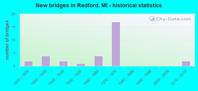
- New bridges - historical statistics
- 21920-1929
- 41930-1939
- 21940-1949
- 11950-1959
- 41960-1969
- 171970-1979
- 22010-2019

- Reconstructed bridges - Historical Statistics
- 11930-1939
- 01940-1949
- 21950-1959
- 11960-1969
- 01970-1979
- 01980-1989
- 31990-1999
- 42000-2009


- Bridge Condition - Deck
- 22.2%Very good
- 38.9%Good
- 22.2%Satisfactory
- 16.7%Fair

- Bridge Condition - Superstructure
- 5.6%Excellent
- 33.3%Good
- 22.2%Satisfactory
- 22.2%Fair
- 16.7%Poor

- Bridge Condition - Substructure
- 5.6%Excellent
- 22.2%Very good
- 27.8%Good
- 27.8%Satisfactory
- 11.1%Fair
- 5.6%Poor

- Bridge Condition - Channel
- 18.2%Very good
- 9.1%Good
- 36.4%Satisfactory
- 27.3%Fair
- 9.1%Poor

- Bridge Condition - Culverts
- 50.0%Good
- 50.0%Satisfactory
Find on map >> Show street view
Structure Number: 1129, Location: 2.1 MI S OF M-5 (Lat: 42.392628, Lng: -83.276214), Route carried "on" structure: US 24, Year Built: 1960, Year Reconstructed: 1996, Status: Open, Structure Length: 3.78m (12.40ft), Average Daily Traffic: 40,989 (year 2018), Truck Traffic: 3%, Average Future Daily Traffic: 47,137 (year 2038), Design Load: HS 25 or greater, Features Intersected: ROUGE RIVER
Minimum Vertical Clearance: 30.48m (100.00ft), Kilometerpoint: 33.746, Lanes on structure: 4, Base Highway Network: Yes (Inventory Route: 470, Subroute: 38), Owner: State Highway Agency, Approaching Roadway Width: 16.4m (53.8ft), Material/Design: Prestressed concrete, Design/Construction: Box Beam or Girders - Multiple, Number Of Spans In Main Unit: 2, Length of Maximum Span: 18.9m (62.0ft), Curb or Sidewalk Widths: Left: 0.0m, Right: 1.7m (5.6ft), Curb-To-Curb Width: 19.8m (65.0ft), Out-to-Out Width: 22.4m (73.5ft)
Condition: Deck: Good, Superstructure: Satisfactory, Substructure: Good, Channel: Very good, Operating Rating: 66.1 metric tons, Method Used To Determine Operating Rating: Load Factor (LF) rating reported by rating factor (RF) method using MS18 loading, Inventory Rating: 39.5 metric tons, Method Used To Determine Inventory Rating: Load Factor (LF) rating reported by rating factor (RF) method using MS18 loading, Structural Evaluation: Equal to present minimum criteria, Deck Geometry: Better than present minimum criteria, Waterway Adequacy: Better than present minimum criteria, Approach Roadway Alignment: Equal to present desirable criteria, Designated Inspection Frequency: Every 24 months, Inspection Date: November 2021, Bridge Improvement Cost: $396,000, Deck Structure Type: Concrete Cast-file-Place, Wearing Surface/Protective System: Wearing Surface: Epoxy Overlay
Find on map >> Show street view
Structure Number: 11291, Location: 2.1 MI S OF M-5 (Lat: 42.392642, Lng: -83.276617), Route carried "on" structure: US 24, Year Built: 1960, Year Reconstructed: 1996, Status: Open, Structure Length: 3.78m (12.40ft), Average Daily Traffic: 40,989 (year 2018), Truck Traffic: 3%, Average Future Daily Traffic: 47,137 (year 2038), Design Load: HS 25 or greater, Features Intersected: ROUGE RIVER
Minimum Vertical Clearance: 30.48m (100.00ft), Kilometerpoint: 22.668, Lanes on structure: 4, Base Highway Network: Yes (Inventory Route: 157, Subroute: 6), Owner: State Highway Agency, Approaching Roadway Width: 16.4m (53.8ft), Material/Design: Prestressed concrete, Design/Construction: Box Beam or Girders - Multiple, Number Of Spans In Main Unit: 2, Length of Maximum Span: 18.9m (62.0ft), Curb or Sidewalk Widths: Left: 1.7m (5.6ft), Right: 0.0m, Curb-To-Curb Width: 19.8m (65.0ft), Out-to-Out Width: 22.4m (73.5ft)
Condition: Deck: Good, Superstructure: Fair, Substructure: Good, Channel: Very good, Operating Rating: 70.6 metric tons, Method Used To Determine Operating Rating: Load Factor (LF) rating reported by rating factor (RF) method using MS18 loading, Inventory Rating: 37.3 metric tons, Method Used To Determine Inventory Rating: Load Factor (LF) rating reported by rating factor (RF) method using MS18 loading, Structural Evaluation: Somewhat better than minimum adequacy, Deck Geometry: Better than present minimum criteria, Waterway Adequacy: Better than present minimum criteria, Approach Roadway Alignment: Equal to present desirable criteria, Designated Inspection Frequency: Every 24 months, Other Special Inspection Frequency: Every 24 months, Inspection Date: November 2021, Other Special Inspection Date: August 2021, Deck Structure Type: Concrete Cast-file-Place, Wearing Surface/Protective System: Wearing Surface: Epoxy Overlay
Find on map >> Show street view
Structure Number: 11501, Location: IN REDFORD TWP (Lat: 42.384717, Lng: -83.307367), Route carried "on" structure: County highway , Year Built: 2014, Status: Open, Structure Length: 6.11m (20.05ft), Average Daily Traffic: 3,000 (year 1995), Truck Traffic: 3%, Average Future Daily Traffic: 4,734 (year 2034), Design Load: Greater than HL93, Features Intersected: I-96, Facility Carried by Structure: BREAKFAST U-TRN LN
Minimum Vertical Clearance: 30.48m (100.00ft), Kilometerpoint: 0.066, Lanes on structure: 2, Lanes under structure: 11, Owner: State Highway Agency, Approaching Roadway Width: 12.2m (40.0ft), Skew: 20 degrees, Material/Design: Prestressed concrete, Design/Construction: Box Beam or Girders - Single/Spread, Number Of Spans In Main Unit: 2, Length of Maximum Span: 30.1m (98.8ft), Curb-To-Curb Width: 12.2m (40.0ft), Out-to-Out Width: 16.0m (52.5ft)
Condition: Deck: Very good, Superstructure: Excellent, Substructure: Excellent, Operating Rating: 53.8 metric tons, Method Used To Determine Operating Rating: Load and Resistance Factor Rating (LRFR) rating reported by rating factor(RF) method using HL-93 loadings, Inventory Rating: 39.5 metric tons, Method Used To Determine Inventory Rating: Load and Resistance Factor Rating (LRFR) rating reported by rating factor(RF) method using HL-93 loadings, Structural Evaluation: Superior to present desirable criteria, Deck Geometry: Equal to present minimum criteria, Underclear: High priority of corrective action, Approach Roadway Alignment: Equal to present desirable criteria, Designated Inspection Frequency: Every 24 months, Inspection Date: September 2020, Deck Structure Type: Concrete Cast-file-Place, Wearing Surface/Protective System: Wearing Surface: Monolithic Concrete, Deck Protection: Epoxy Coated Reinforcing
Find on map >> Show street view
Structure Number: 11502, Location: IN REDFORD TWP (Lat: 42.384864, Lng: -83.295378), Route carried "on" structure: County highway 2057, Year Built: 1974, Year Reconstructed: 2014, Status: Open, Structure Length: 5.39m (17.68ft), Average Daily Traffic: 37,500 (year 1996), Truck Traffic: 12%, Average Future Daily Traffic: 21,416 (year 2034), Design Load: HS 20, Features Intersected: I-96, Facility Carried by Structure: BEECH DALY RD
Minimum Vertical Clearance: 30.48m (100.00ft), Kilometerpoint: 3.166, Lanes on structure: 5, Lanes under structure: 8, Owner: State Highway Agency, Approaching Roadway Width: 19.5m (64.0ft), Material/Design: Steel, Design/Construction: Stringer/Multi-beam, Number Of Spans In Main Unit: 2, Length of Maximum Span: 26.6m (87.3ft), Curb or Sidewalk Widths: Left: 2.4m (7.9ft), Right: 2.4m (7.9ft), Curb-To-Curb Width: 19.5m (64.0ft), Out-to-Out Width: 25.1m (82.3ft)
Condition: Deck: Very good, Superstructure: Good, Substructure: Very good, Operating Rating: 63.8 metric tons, Method Used To Determine Operating Rating: Load Factor (LF) rating reported by rating factor (RF) method using MS18 loading, Inventory Rating: 38.2 metric tons, Method Used To Determine Inventory Rating: Load Factor (LF) rating reported by rating factor (RF) method using MS18 loading, Structural Evaluation: Better than present minimum criteria, Deck Geometry: Meets minimum limits, Underclear: Somewhat better than minimum adequacy, Approach Roadway Alignment: Equal to present desirable criteria, Designated Inspection Frequency: Every 24 months, Inspection Date: September 2020, Deck Structure Type: Concrete Cast-file-Place, Wearing Surface/Protective System: Wearing Surface: Monolithic Concrete, Deck Protection: Epoxy Coated Reinforcing
Find on map >> Show street view
Structure Number: 11503, Location: IN REDFORD TWP (Lat: 42.384944, Lng: -83.288714), Route carried "on" structure: County highway , Year Built: 1974, Year Reconstructed: 2014, Status: Open, Structure Length: 6.10m (20.01ft), Average Daily Traffic: 5,600 (year 1995), Average Future Daily Traffic: 902 (year 2034), Design Load: HS 20, Features Intersected: I-96, Facility Carried by Structure: GARFIELD ST U-TRN
Minimum Vertical Clearance: 30.48m (100.00ft), Kilometerpoint: 0.040, Lanes on structure: 2, Lanes under structure: 10, Owner: State Highway Agency, Approaching Roadway Width: 14.3m (46.9ft), Skew: 30 degrees, Material/Design: Steel, Design/Construction: Stringer/Multi-beam, Number Of Spans In Main Unit: 2, Length of Maximum Span: 30.1m (98.8ft), Curb-To-Curb Width: 12.2m (40.0ft), Out-to-Out Width: 15.1m (49.5ft)
Condition: Deck: Very good, Superstructure: Good, Substructure: Very good, Operating Rating: 67.4 metric tons, Method Used To Determine Operating Rating: Load Factor (LF) rating reported by rating factor (RF) method using MS18 loading, Inventory Rating: 40.5 metric tons, Method Used To Determine Inventory Rating: Load Factor (LF) rating reported by rating factor (RF) method using MS18 loading, Structural Evaluation: Better than present minimum criteria, Deck Geometry: Somewhat better than minimum adequacy, Underclear: High priority of corrective action, Approach Roadway Alignment: Equal to present desirable criteria, Designated Inspection Frequency: Every 24 months, Inspection Date: September 2020, Deck Structure Type: Concrete Cast-file-Place, Wearing Surface/Protective System: Wearing Surface: Monolithic Concrete, Deck Protection: Epoxy Coated Reinforcing
Find on map >> Show street view
Structure Number: 11504, Location: IN REDFORD TWP (Lat: 42.385036, Lng: -83.280814), Route carried "on" structure: County highway , Year Built: 1974, Year Reconstructed: 2014, Status: Open, Structure Length: 6.29m (20.64ft), Average Daily Traffic: 1,550 (year 2012), Truck Traffic: 2%, Average Future Daily Traffic: 1,747 (year 2034), Design Load: HS 20, Features Intersected: I-96, Facility Carried by Structure: FENTON ST
Minimum Vertical Clearance: 30.48m (100.00ft), Kilometerpoint: 0.484, Lanes on structure: 2, Lanes under structure: 10, Owner: State Highway Agency, Approaching Roadway Width: 9.1m (29.9ft), Material/Design: Steel, Design/Construction: Stringer/Multi-beam, Number Of Spans In Main Unit: 2, Length of Maximum Span: 31.5m (103.3ft), Curb or Sidewalk Widths: Left: 2.4m (7.9ft), Right: 2.4m (7.9ft), Curb-To-Curb Width: 9.1m (29.9ft), Out-to-Out Width: 14.8m (48.6ft)
Condition: Deck: Very good, Superstructure: Good, Substructure: Very good, Operating Rating: 63.8 metric tons, Method Used To Determine Operating Rating: Load Factor (LF) rating reported by rating factor (RF) method using MS18 loading, Inventory Rating: 38.2 metric tons, Method Used To Determine Inventory Rating: Load Factor (LF) rating reported by rating factor (RF) method using MS18 loading, Structural Evaluation: Better than present minimum criteria, Deck Geometry: Somewhat better than minimum adequacy, Underclear: High priority of corrective action, Approach Roadway Alignment: Equal to present desirable criteria, Designated Inspection Frequency: Every 24 months, Inspection Date: September 2020, Deck Structure Type: Concrete Cast-file-Place, Wearing Surface/Protective System: Wearing Surface: Monolithic Concrete, Deck Protection: Epoxy Coated Reinforcing
Find on map >> Show street view
Structure Number: 11505, Location: W LTS OF DETROIT (Lat: 42.384864, Lng: -83.276039), Route carried "on" structure: US 24, Year Built: 1970, Year Reconstructed: 2003, Status: Open, Structure Length: 27.43m (89.99ft), Average Daily Traffic: 69,110 (year 2007), Truck Traffic: 5%, Average Future Daily Traffic: 68,228 (year 2018), Design Load: HS 20, Features Intersected: I-96
Minimum Vertical Clearance: 30+ m (98+ ft), Kilometerpoint: 32.927, Lanes on structure: 6, Lanes under structure: 10, Base Highway Network: Yes (Inventory Route: 470, Subroute: 38), Owner: State Highway Agency, Approaching Roadway Width: 26.8m (87.9ft), Skew: 30 degrees, Material/Design: Steel continuous, Design/Construction: Stringer/Multi-beam, Number Of Spans In Main Unit: 7, Length of Maximum Span: 50.3m (165.0ft), Curb-To-Curb Width: 26.8m (87.9ft), Out-to-Out Width: 27.2m (89.2ft)
Condition: Deck: Good, Superstructure: Satisfactory, Substructure: Satisfactory, Operating Rating: 78.4 metric tons, Method Used To Determine Operating Rating: Load Factor (LF) rating reported by rating factor (RF) method using MS18 loading, Inventory Rating: 47.0 metric tons, Method Used To Determine Inventory Rating: Load Factor (LF) rating reported by rating factor (RF) method using MS18 loading, Structural Evaluation: Equal to present minimum criteria, Deck Geometry: Better than present minimum criteria, Underclear: Better than present minimum criteria, Approach Roadway Alignment: Equal to present desirable criteria, Designated Inspection Frequency: Every 24 months, Inspection Date: April 2020, Deck Structure Type: Concrete Cast-file-Place, Wearing Surface/Protective System: Wearing Surface: Monolithic Concrete, Deck Protection: Epoxy Coated Reinforcing
Find on map >> Show street view
Structure Number: 11514, Location: IN REDFORD TWP (Lat: 42.384889, Lng: -83.299486), Route carried "on" structure: County highway , Year Built: 1973, Year Reconstructed: 2014, Status: Open, Structure Length: 6.71m (22.01ft), Average Daily Traffic: 1,540 (year 2012), Truck Traffic: 2%, Average Future Daily Traffic: 1,736 (year 2034), Design Load: HS 20, Features Intersected: I-96, Facility Carried by Structure: BERWYN STREET
Minimum Vertical Clearance: 30.48m (100.00ft), Kilometerpoint: 0.042, Lanes on structure: 2, Lanes under structure: 10, Owner: State Highway Agency, Approaching Roadway Width: 8.5m (27.9ft), Material/Design: Steel, Design/Construction: Stringer/Multi-beam, Number Of Spans In Main Unit: 2, Length of Maximum Span: 37.3m (122.4ft), Curb or Sidewalk Widths: Left: 2.4m (7.9ft), Right: 2.4m (7.9ft), Curb-To-Curb Width: 8.5m (27.9ft), Out-to-Out Width: 14.1m (46.3ft)
Condition: Deck: Good, Superstructure: Satisfactory, Substructure: Good, Operating Rating: 70.3 metric tons, Method Used To Determine Operating Rating: Load Factor (LF) rating reported by rating factor (RF) method using MS18 loading, Inventory Rating: 42.1 metric tons, Method Used To Determine Inventory Rating: Load Factor (LF) rating reported by rating factor (RF) method using MS18 loading, Structural Evaluation: Equal to present minimum criteria, Deck Geometry: Somewhat better than minimum adequacy, Underclear: High priority of corrective action, Approach Roadway Alignment: Equal to present minimum criteria, Designated Inspection Frequency: Every 24 months, Inspection Date: September 2020, Deck Structure Type: Concrete Cast-file-Place, Wearing Surface/Protective System: Wearing Surface: Monolithic Concrete, Deck Protection: Epoxy Coated Reinforcing
Find on map >> Show street view
Structure Number: 11522, Location: IN REDFORD TWP (Lat: 42.385100, Lng: -83.296414), Route carried "on" structure: ServiceCounty highway 2057, Year Built: 1974, Status: Open, Structure Length: 5.38m (17.65ft), Average Daily Traffic: 2,800 (year 1995), Average Future Daily Traffic: 2,800 (year 2015), Design Load: HS 20, Features Intersected: I-96, Facility Carried by Structure: LFT TRN BEECH DALY
Minimum Vertical Clearance: 30.48m (100.00ft), Kilometerpoint: 0.061, Lanes on structure: 2, Lanes under structure: 8, Owner: State Highway Agency, Approaching Roadway Width: 5.4m (17.7ft), Material/Design: Steel, Design/Construction: Stringer/Multi-beam, Number Of Spans In Main Unit: 2, Length of Maximum Span: 26.5m (86.9ft), Curb or Sidewalk Widths: Left: 0.2m (0.7ft), Right: 0.2m (0.7ft), Curb-To-Curb Width: 6.1m (20.0ft), Out-to-Out Width: 7.2m (23.6ft)
Condition: Deck: Good, Superstructure: Good, Substructure: Good, Operating Rating: 63.5 metric tons, Method Used To Determine Operating Rating: Load Factor (LF) rating reported by rating factor (RF) method using MS18 loading, Inventory Rating: 37.9 metric tons, Method Used To Determine Inventory Rating: Load Factor (LF) rating reported by rating factor (RF) method using MS18 loading, Structural Evaluation: Better than present minimum criteria, Deck Geometry: High priority of replacement, Underclear: Meets minimum limits, Approach Roadway Alignment: Equal to present desirable criteria, Length Of Structure Improvement: 5.40m (17.72ft), Designated Inspection Frequency: Every 24 months, Inspection Date: September 2020, Bridge Improvement Cost: $91,000, Roadway Improvement Cost: $7,000, Total Project Cost: $79,000, Deck Structure Type: Concrete Cast-file-Place, Wearing Surface/Protective System: Wearing Surface: Epoxy Overlay
Find on map >> Show street view
Structure Number: 11523, Location: IN REDFORD TWP (Lat: 42.385058, Lng: -83.294133), Route carried "on" structure: ServiceInterstate 96, Year Built: 1974, Status: Open, Structure Length: 5.38m (17.65ft), Average Daily Traffic: 2,800 (year 1995), Truck Traffic: 5%, Average Future Daily Traffic: 2,800 (year 2015), Design Load: HS 20, Features Intersected: I-96, Facility Carried by Structure: LFT TRN E BEECH DL
Minimum Vertical Clearance: 30.48m (100.00ft), Kilometerpoint: 0.040, Lanes on structure: 1, Lanes under structure: 8, Owner: State Highway Agency, Approaching Roadway Width: 5.4m (17.7ft), Material/Design: Steel, Design/Construction: Stringer/Multi-beam, Number Of Spans In Main Unit: 2, Length of Maximum Span: 26.5m (86.9ft), Curb or Sidewalk Widths: Left: 0.2m (0.7ft), Right: 0.2m (0.7ft), Curb-To-Curb Width: 6.0m (19.7ft), Out-to-Out Width: 7.2m (23.6ft)
Condition: Deck: Good, Superstructure: Good, Substructure: Very good, Operating Rating: 80.4 metric tons, Method Used To Determine Operating Rating: Load Factor (LF) rating reported by rating factor (RF) method using MS18 loading, Inventory Rating: 48.0 metric tons, Method Used To Determine Inventory Rating: Load Factor (LF) rating reported by rating factor (RF) method using MS18 loading, Structural Evaluation: Better than present minimum criteria, Deck Geometry: High priority of replacement, Underclear: High priority of corrective action, Approach Roadway Alignment: Equal to present desirable criteria, Length Of Structure Improvement: 5.40m (17.72ft), Designated Inspection Frequency: Every 24 months, Inspection Date: September 2020, Bridge Improvement Cost: $91,000, Roadway Improvement Cost: $7,000, Total Project Cost: $79,000, Deck Structure Type: Concrete Cast-file-Place, Wearing Surface/Protective System: Wearing Surface: Epoxy Overlay
Find on map >> Show street view
Structure Number: 12076, Location: REDFORD E/INKSTER (Lat: 42.398922, Lng: -83.308883), Route carried "on" structure: County highway 2057, Year Built: 1925, Year Reconstructed: 1935, Status: Posted for load, Structure Length: 2.47m (8.10ft), Average Daily Traffic: 18,173 (year 1995), Truck Traffic: 5%, Average Future Daily Traffic: 19,798 (year 2015), Design Load: HS 20+Mod, Features Intersected: BELL CREEK, Facility Carried by Structure: FIVE MILE ROAD
Minimum Vertical Clearance: 30.48m (100.00ft), Kilometerpoint: 0.502, Lanes on structure: 4, Owner: County Highway Agency, Approaching Roadway Width: 17.6m (57.7ft), Skew: 4 degrees, Material/Design: Concrete, Design/Construction: Tee Beam, Number Of Spans In Main Unit: 2, Length of Maximum Span: 11.2m (36.7ft), Curb or Sidewalk Widths: Left: 0.9m (3.0ft), Right: 0.9m (3.0ft), Curb-To-Curb Width: 15.2m (49.9ft), Out-to-Out Width: 18.3m (60.0ft)
Condition: Deck: Fair, Superstructure: Poor, Substructure: Poor, Channel: Poor, Operating Rating: 30.8 metric tons, Method Used To Determine Operating Rating: Load Factor (LF) rating reported by rating factor (RF) method using MS18 loading, Inventory Rating: 18.5 metric tons, Method Used To Determine Inventory Rating: Load Factor (LF) rating reported by rating factor (RF) method using MS18 loading, Structural Evaluation: Meets minimum limits, Deck Geometry: High priority of corrective action, Waterway Adequacy: Equal to present desirable criteria, Approach Roadway Alignment: Equal to present desirable criteria, Bridge Posting: Required (Relationship of Operating Rating to Maximum Legal Load: 30.0 - 39.9% below), Designated Inspection Frequency: Every 12 months, Inspection Date: May 2021, Deck Structure Type: Concrete Cast-file-Place, Wearing Surface/Protective System: Wearing Surface: Bituminous
Find on map >> Show street view
Structure Number: 12077, Location: REDFORD E/BEECH-DALY (Lat: 42.399814, Lng: -83.286036), Route carried "on" structure: County highway 2057, Year Built: 1978, Status: Posted for load, Structure Length: 2.86m (9.38ft), Average Daily Traffic: 19,861 (year 1995), Truck Traffic: 5%, Average Future Daily Traffic: 19,334 (year 2015), Design Load: HS 20+Mod, Features Intersected: UPPER ROUGE RIVER, Facility Carried by Structure: FIVE MILE ROAD
Minimum Vertical Clearance: 30.48m (100.00ft), Kilometerpoint: 2.385, Lanes on structure: 5, Owner: County Highway Agency, Approaching Roadway Width: 18.9m (62.0ft), Skew: 1 degrees, Material/Design: Steel continuous, Design/Construction: Stringer/Multi-beam, Number Of Spans In Main Unit: 3, Length of Maximum Span: 12.8m (42.0ft), Curb or Sidewalk Widths: Left: 3.0m (9.8ft), Right: 3.0m (9.8ft), Curb-To-Curb Width: 18.9m (62.0ft), Out-to-Out Width: 25.7m (84.3ft)
Condition: Deck: Good, Superstructure: Good, Substructure: Good, Channel: Fair, Operating Rating: 44.7 metric tons, Method Used To Determine Operating Rating: Load Factor (LF) rating reported by rating factor (RF) method using MS18 loading, Inventory Rating: 26.9 metric tons, Method Used To Determine Inventory Rating: Load Factor (LF) rating reported by rating factor (RF) method using MS18 loading, Structural Evaluation: Equal to present minimum criteria, Deck Geometry: Meets minimum limits, Waterway Adequacy: Equal to present desirable criteria, Approach Roadway Alignment: Equal to present desirable criteria, Bridge Posting: Required (Relationship of Operating Rating to Maximum Legal Load: 20.0 - 29.9% below), Designated Inspection Frequency: Every 24 months, Inspection Date: June 2021, Deck Structure Type: Concrete Cast-file-Place, Wearing Surface/Protective System: Wearing Surface: Monolithic Concrete
Find on map >> Show street view
Structure Number: 12078, Location: REDFORD W/TELEGRAPH (Lat: 42.399983, Lng: -83.279703), Route carried "on" structure: County highway 2057, Year Built: 1979, Status: Open, Structure Length: 0.64m (2.10ft), Average Daily Traffic: 19,861 (year 1995), Truck Traffic: 5%, Average Future Daily Traffic: 19,334 (year 2015), Features Intersected: SMITH DRAIN, Facility Carried by Structure: FIVE MILE ROAD
Minimum Vertical Clearance: 30.48m (100.00ft), Kilometerpoint: 2.907, Lanes on structure: 5, Owner: County Highway Agency, Approaching Roadway Width: 18.9m (62.0ft), Material/Design: Steel, Design/Construction: Culvert, Number Of Spans In Main Unit: 2, Length of Maximum Span: 2.7m (8.9ft), Curb or Sidewalk Widths: Left: 0.0m, Right: 1.5m (4.9ft), Curb-To-Curb Width: 18.9m (62.0ft), Out-to-Out Width: 27.4m (89.9ft)
Condition: Channel: Fair, Culverts: Satisfactory, Operating Rating: 97.2 metric tons, Method Used To Determine Operating Rating: Load Factor (LF) rating reported by rating factor (RF) method using MS18 loading, Inventory Rating: 97.2 metric tons, Method Used To Determine Inventory Rating: Load Factor (LF) rating reported by rating factor (RF) method using MS18 loading, Structural Evaluation: Equal to present minimum criteria, Deck Geometry: Meets minimum limits, Waterway Adequacy: Equal to present minimum criteria, Approach Roadway Alignment: Equal to present desirable criteria, Designated Inspection Frequency: Every 24 months, Inspection Date: June 2021
Find on map >> Show street view
Structure Number: 1209, Location: REDFORD E/INKSTER (Lat: 42.413528, Lng: -83.307792), Route carried "on" structure: County highway 2057, Year Built: 1927, Year Reconstructed: 1960, Status: Posted for load, Structure Length: 1.04m (3.41ft), Average Daily Traffic: 8,328 (year 1997), Truck Traffic: 5%, Average Future Daily Traffic: 17,936 (year 2015), Design Load: HS 20+Mod, Features Intersected: UPPER ROUGE RIVER, Facility Carried by Structure: SIX MILE ROAD
Minimum Vertical Clearance: 30.48m (100.00ft), Kilometerpoint: 20.024, Lanes on structure: 4, Base Highway Network: Yes (Inventory Route: 168, Subroute: 1), Owner: County Highway Agency, Approaching Roadway Width: 14.0m (45.9ft), Material/Design: Concrete, Design/Construction: Tee Beam, Number Of Spans In Main Unit: 1, Length of Maximum Span: 9.7m (31.8ft), Curb or Sidewalk Widths: Left: 1.2m (3.9ft), Right: 1.2m (3.9ft), Curb-To-Curb Width: 14.0m (45.9ft), Out-to-Out Width: 17.1m (56.1ft)
Condition: Deck: Fair, Superstructure: Poor, Substructure: Fair, Channel: Satisfactory, Operating Rating: 44.1 metric tons, Method Used To Determine Operating Rating: Load Factor (LF) rating reported by rating factor (RF) method using MS18 loading, Inventory Rating: 26.2 metric tons, Method Used To Determine Inventory Rating: Load Factor (LF) rating reported by rating factor (RF) method using MS18 loading, Structural Evaluation: Meets minimum limits, Deck Geometry: High priority of replacement, Waterway Adequacy: Equal to present desirable criteria, Approach Roadway Alignment: Equal to present desirable criteria, Bridge Posting: Required (Relationship of Operating Rating to Maximum Legal Load: 20.0 - 29.9% below), Designated Inspection Frequency: Every 12 months, Inspection Date: June 2021, Deck Structure Type: Concrete Cast-file-Place, Wearing Surface/Protective System: Wearing Surface: Bituminous
Find on map >> Show street view
Structure Number: 12174, Location: REDFORD TWP S/FIVE MILE (Lat: 42.392108, Lng: -83.295564), Route carried "on" structure: County highway 2057, Year Built: 1933, Year Reconstructed: 1961, Status: Posted for load, Structure Length: 2.07m (6.79ft), Average Daily Traffic: 24,472 (year 1995), Truck Traffic: 5%, Average Future Daily Traffic: 28,183 (year 2015), Design Load: HS 20+Mod, Features Intersected: BELL CREEK, Facility Carried by Structure: BEECH-DALY ROAD
Minimum Vertical Clearance: 30.48m (100.00ft), Kilometerpoint: 3.970, Lanes on structure: 4, Owner: County Highway Agency, Approaching Roadway Width: 18.2m (59.7ft), Material/Design: Steel continuous, Design/Construction: Stringer/Multi-beam, Number Of Spans In Main Unit: 2, Length of Maximum Span: 9.7m (31.8ft), Curb or Sidewalk Widths: Left: 1.7m (5.6ft), Right: 1.7m (5.6ft), Curb-To-Curb Width: 14.6m (47.9ft), Out-to-Out Width: 19.0m (62.3ft)
Condition: Deck: Satisfactory, Superstructure: Fair, Substructure: Satisfactory, Channel: Satisfactory, Operating Rating: 37.9 metric tons, Method Used To Determine Operating Rating: Load Factor (LF) rating reported by rating factor (RF) method using MS18 loading, Inventory Rating: 22.7 metric tons, Method Used To Determine Inventory Rating: Load Factor (LF) rating reported by rating factor (RF) method using MS18 loading, Structural Evaluation: Somewhat better than minimum adequacy, Deck Geometry: High priority of replacement, Waterway Adequacy: Superior to present desirable criteria, Approach Roadway Alignment: Equal to present desirable criteria, Bridge Posting: Required (Relationship of Operating Rating to Maximum Legal Load: 20.0 - 29.9% below), Designated Inspection Frequency: Every 12 months, Inspection Date: June 2021, Deck Structure Type: Concrete Cast-file-Place, Wearing Surface/Protective System: Wearing Surface: Bituminous
Find on map >> Show street view
Structure Number: 12175, Location: REDFORD N/FIVE MILE (Lat: 42.407297, Lng: -83.296203), Route carried "on" structure: County highway 2057, Year Built: 1932, Year Reconstructed: 1961, Status: Open, Structure Length: 1.03m (3.38ft), Average Daily Traffic: 29,650 (year 1995), Truck Traffic: 5%, Average Future Daily Traffic: 31,100 (year 2015), Design Load: HS 20+Mod, Features Intersected: ROUGE RIVER, Facility Carried by Structure: BEECH-DALY ROAD
Minimum Vertical Clearance: 30.48m (100.00ft), Kilometerpoint: 5.657, Lanes on structure: 4, Owner: County Highway Agency, Approaching Roadway Width: 18.2m (59.7ft), Material/Design: Prestressed concrete, Design/Construction: Box Beam or Girders - Multiple, Number Of Spans In Main Unit: 1, Length of Maximum Span: 9.1m (29.9ft), Curb or Sidewalk Widths: Left: 1.6m (5.2ft), Right: 1.6m (5.2ft), Curb-To-Curb Width: 14.6m (47.9ft), Out-to-Out Width: 18.8m (61.7ft)
Condition: Deck: Satisfactory, Superstructure: Fair, Substructure: Satisfactory, Channel: Good, Operating Rating: 54.4 metric tons, Method Used To Determine Operating Rating: Load Factor (LF) rating reported by rating factor (RF) method using MS18 loading, Inventory Rating: 32.4 metric tons, Method Used To Determine Inventory Rating: Load Factor (LF) rating reported by rating factor (RF) method using MS18 loading, Structural Evaluation: Somewhat better than minimum adequacy, Deck Geometry: High priority of replacement, Waterway Adequacy: Better than present minimum criteria, Approach Roadway Alignment: Equal to present desirable criteria, Designated Inspection Frequency: Every 24 months, Inspection Date: June 2021, Deck Structure Type: Concrete Cast-file-Place, Wearing Surface/Protective System: Wearing Surface: Bituminous, Deck Protection: Epoxy Coated Reinforcing
Find on map >> Show street view
Structure Number: 12176, Location: REDFORD S/FIVE MILE (Lat: 42.393050, Lng: -83.295597), Route carried "on" structure: County highway 2057, Year Built: 1961, Status: Open, Structure Length: 0.61m (2.00ft), Average Daily Traffic: 24,472 (year 1995), Average Future Daily Traffic: 28,143 (year 2015), Design Load: HS 20+Mod, Features Intersected: WESTERN GOLF CLUB PATH, Facility Carried by Structure: BEECH-DALY ROAD
Minimum Vertical Clearance: 30.48m (100.00ft), Kilometerpoint: 0.000, Lanes on structure: 4, Owner: County Highway Agency, Approaching Roadway Width: 18.3m (60.0ft), Material/Design: Steel, Design/Construction: Culvert, Number Of Spans In Main Unit: 1, Length of Maximum Span: 6.1m (20.0ft), Curb-To-Curb Width: 14.6m (47.9ft), Out-to-Out Width: 18.3m (60.0ft)
Condition: Culverts: Good, Operating Rating: 51.2 metric tons, Method Used To Determine Operating Rating: Load Factor (LF) rating reported by rating factor (RF) method using MS18 loading, Inventory Rating: 30.8 metric tons, Method Used To Determine Inventory Rating: Load Factor (LF) rating reported by rating factor (RF) method using MS18 loading, Structural Evaluation: Better than present minimum criteria, Deck Geometry: High priority of replacement, Approach Roadway Alignment: Equal to present desirable criteria, Designated Inspection Frequency: Every 24 months, Inspection Date: June 2021, Wearing Surface/Protective System: Deck Protection: Internally Sealed
Find on map >> Show street view
Structure Number: 12287, Location: REDFORD N/FIVE MILE (Lat: 42.403236, Lng: -83.288747), Route carried "on" structure: County highway , Year Built: 1948, Status: Open, Structure Length: 1.89m (6.20ft), Average Daily Traffic: 1,000 (year 1987), Truck Traffic: 2%, Average Future Daily Traffic: 1,100 (year 2015), Design Load: H 20, Features Intersected: UPPER ROUGE RIVER, Facility Carried by Structure: GARFIELD STREET
Minimum Vertical Clearance: 30.48m (100.00ft), Kilometerpoint: 0.386, Lanes on structure: 2, Owner: County Highway Agency, Approaching Roadway Width: 8.5m (27.9ft), Material/Design: Steel continuous, Design/Construction: Stringer/Multi-beam, Number Of Spans In Main Unit: 3, Length of Maximum Span: 8.8m (28.9ft), Curb or Sidewalk Widths: Left: 1.1m (3.6ft), Right: 1.1m (3.6ft), Curb-To-Curb Width: 7.3m (24.0ft), Out-to-Out Width: 10.2m (33.5ft)
Condition: Deck: Satisfactory, Superstructure: Fair, Substructure: Satisfactory, Channel: Satisfactory, Operating Rating: 53.1 metric tons, Method Used To Determine Operating Rating: Load Factor (LF) rating reported by rating factor (RF) method using MS18 loading, Inventory Rating: 38.9 metric tons, Method Used To Determine Inventory Rating: Load Factor (LF) rating reported by rating factor (RF) method using MS18 loading, Structural Evaluation: Somewhat better than minimum adequacy, Deck Geometry: Meets minimum limits, Waterway Adequacy: Better than present minimum criteria, Approach Roadway Alignment: Equal to present desirable criteria, Designated Inspection Frequency: Every 24 months, Inspection Date: June 2021, Deck Structure Type: Concrete Cast-file-Place, Wearing Surface/Protective System: Wearing Surface: Bituminous
Find on map >> Show street view
Structure Number: 12288, Location: REDFORD S/SIX MILE (Lat: 42.410417, Lng: -83.301708), Route carried "on" structure: County highway , Year Built: 1934, Status: Open, Structure Length: 0.97m (3.18ft), Average Daily Traffic: 4,000 (year 1987), Truck Traffic: 1%, Average Future Daily Traffic: 4,400 (year 2015), Design Load: HS 20+Mod, Features Intersected: UPPER ROUGE RIVER, Facility Carried by Structure: KINLOCH STREET
Minimum Vertical Clearance: 30.48m (100.00ft), Kilometerpoint: 1.980, Lanes on structure: 2, Owner: County Highway Agency, Approaching Roadway Width: 13.4m (44.0ft), Material/Design: Concrete, Design/Construction: Tee Beam, Number Of Spans In Main Unit: 1, Length of Maximum Span: 8.5m (27.9ft), Curb or Sidewalk Widths: Left: 1.0m (3.3ft), Right: 1.0m (3.3ft), Curb-To-Curb Width: 9.2m (30.2ft), Out-to-Out Width: 12.5m (41.0ft)
Condition: Deck: Fair, Superstructure: Poor, Substructure: Fair, Channel: Fair, Operating Rating: 64.2 metric tons, Method Used To Determine Operating Rating: Load Factor (LF) rating reported by rating factor (RF) method using MS18 loading, Inventory Rating: 38.2 metric tons, Method Used To Determine Inventory Rating: Load Factor (LF) rating reported by rating factor (RF) method using MS18 loading, Structural Evaluation: Meets minimum limits, Deck Geometry: Meets minimum limits, Waterway Adequacy: Equal to present desirable criteria, Approach Roadway Alignment: Equal to present desirable criteria, Designated Inspection Frequency: Every 12 months, Inspection Date: June 2021, Deck Structure Type: Concrete Cast-file-Place, Wearing Surface/Protective System: Wearing Surface: Bituminous
Find on map >> Show street view
Structure Number: 12289, Location: REDFORD W/TELEGRAPH (Lat: 42.398200, Lng: -83.278331), Route carried "on" structure: County highway , Year Built: 1947, Status: Posted for load, Structure Length: 1.95m (6.40ft), Average Daily Traffic: 500 (year 1987), Truck Traffic: 1%, Average Future Daily Traffic: 550 (year 2015), Design Load: H 20, Features Intersected: UPPER ROUGE RIVER, Facility Carried by Structure: GRAHAM ROAD
Minimum Vertical Clearance: 30.48m (100.00ft), Kilometerpoint: 0.641, Lanes on structure: 2, Owner: County Highway Agency, Approaching Roadway Width: 8.5m (27.9ft), Material/Design: Concrete continuous, Design/Construction: Slab, Number Of Spans In Main Unit: 3, Length of Maximum Span: 7.3m (24.0ft), Curb or Sidewalk Widths: Left: 0.6m (2.0ft), Right: 0.6m (2.0ft), Curb-To-Curb Width: 7.3m (24.0ft), Out-to-Out Width: 9.1m (29.9ft)
Condition: Deck: Satisfactory, Superstructure: Satisfactory, Substructure: Satisfactory, Channel: Satisfactory, Operating Rating: 28.2 metric tons, Method Used To Determine Operating Rating: Load Factor (LF) rating reported by rating factor (RF) method using MS18 loading, Inventory Rating: 16.8 metric tons, Method Used To Determine Inventory Rating: Load Factor (LF) rating reported by rating factor (RF) method using MS18 loading, Structural Evaluation: Somewhat better than minimum adequacy, Deck Geometry: Meets minimum limits, Waterway Adequacy: Equal to present desirable criteria, Approach Roadway Alignment: Equal to present desirable criteria, Bridge Posting: Required (Relationship of Operating Rating to Maximum Legal Load: > 39.9% below), Designated Inspection Frequency: Every 24 months, Inspection Date: May 2021, Deck Structure Type: Concrete Cast-file-Place, Wearing Surface/Protective System: Wearing Surface: Integral Concrete
Find on map >> Show street view
Structure Number: 11297, Location: 0.5 MI N OF M-14 (Lat: 42.378417, Lng: -83.275725), Route carried "under" structure: US 24, Year Built: 1961, Structure Length: 0. m, Average Daily Traffic: 34,555 (year 2007), Truck Traffic: 5%, Features Intersected: US-24 NB, Facility Carried by Structure: CSX RR
Minimum Vertical Clearance: 4.50m (14.76ft), Kilometerpoint: 21.094, Lanes under structure: 4, Material/Design: Steel, Design/Construction: Girder and Floorbeam System, Length of Maximum Span: 24.3m (79.7ft)
Find on map >> Show street view
Structure Number: 11298, Location: 0.5 MI N OF M-14 (Lat: 42.378428, Lng: -83.275303), Route carried "under" structure: US 24, Year Built: 1936, Structure Length: 0. m, Average Daily Traffic: 34,555 (year 2007), Truck Traffic: 5%, Features Intersected: US-24 SB, Facility Carried by Structure: CSX RR
Minimum Vertical Clearance: 4.60m (15.09ft), Kilometerpoint: 32.175, Lanes under structure: 4, Material/Design: Steel, Design/Construction: Girder and Floorbeam System, Length of Maximum Span: 20.1m (65.9ft)
Find on map >> Show street view
Structure Number: 11484, Location: IN REDFORD TWP (Lat: 42.384936, Lng: -83.303153), Route carried "under" structure: Interstate 96, Year Built: 1974, Structure Length: 0. m, Average Daily Traffic: 150,540 (year 2007), Truck Traffic: 7%, Features Intersected: I-96, Facility Carried by Structure: MINOCK PED X-OVER
Minimum Vertical Clearance: 5.41m (17.75ft), Kilometerpoint: 11.974, Lanes under structure: 10, Material/Design: Steel continuous, Design/Construction: Stringer/Multi-beam, Length of Maximum Span: 32.6m (107.0ft)
Find on map >> Show street view
Structure Number: 11501, Location: IN REDFORD TWP (Lat: 42.384717, Lng: -83.307367), Route carried "under" structure: Interstate 96, Year Built: 2014, Structure Length: 0. m, Average Daily Traffic: 145,900 (year 2012), Truck Traffic: 4%, Features Intersected: I-96, Facility Carried by Structure: BREAKFAST U-TRN LN
Minimum Vertical Clearance: 4.62m (15.16ft), Kilometerpoint: 11.626, Lanes on structure: 2, Lanes under structure: 11, Material/Design: Prestressed concrete, Design/Construction: Box Beam or Girders - Single/Spread, Length of Maximum Span: 30.1m (98.8ft)
Find on map >> Show street view
Structure Number: 11502, Location: IN REDFORD TWP (Lat: 42.384864, Lng: -83.295378), Route carried "under" structure: Interstate 96, Year Built: 1974, Structure Length: 0. m, Average Daily Traffic: 145,900 (year 2012), Truck Traffic: 4%, Features Intersected: I-96, Facility Carried by Structure: BEECH DALY RD
Minimum Vertical Clearance: 5.08m (16.67ft), Kilometerpoint: 12.614, Lanes on structure: 5, Lanes under structure: 8, Material/Design: Steel, Design/Construction: Stringer/Multi-beam, Length of Maximum Span: 26.6m (87.3ft)
Find on map >> Show street view
Structure Number: 11503, Location: IN REDFORD TWP (Lat: 42.384944, Lng: -83.288714), Route carried "under" structure: Interstate 96, Year Built: 1974, Structure Length: 0. m, Average Daily Traffic: 139,400 (year 2012), Truck Traffic: 5%, Features Intersected: I-96, Facility Carried by Structure: GARFIELD ST U-TRN
Minimum Vertical Clearance: 4.47m (14.67ft), Kilometerpoint: 13.155, Lanes on structure: 2, Lanes under structure: 10, Material/Design: Steel, Design/Construction: Stringer/Multi-beam, Length of Maximum Span: 30.1m (98.8ft)
Find on map >> Show street view
Structure Number: 11504, Location: IN REDFORD TWP (Lat: 42.385036, Lng: -83.280814), Route carried "under" structure: Interstate 96, Year Built: 1974, Structure Length: 0. m, Average Daily Traffic: 139,400 (year 2012), Truck Traffic: 5%, Features Intersected: I-96, Facility Carried by Structure: FENTON ST
Minimum Vertical Clearance: 4.52m (14.83ft), Kilometerpoint: 13.813, Lanes on structure: 2, Lanes under structure: 10, Material/Design: Steel, Design/Construction: Stringer/Multi-beam, Length of Maximum Span: 31.5m (103.3ft)
Find on map >> Show street view
Structure Number: 11505, Location: W LTS OF DETROIT (Lat: 42.384864, Lng: -83.276039), Route carried "under" structure: Interstate 96, Year Built: 1970, Structure Length: 0. m, Average Daily Traffic: 164,804 (year 2007), Truck Traffic: 5%, Features Intersected: I-96, Facility Carried by Structure: US-24 TELEGRAPH RD
Minimum Vertical Clearance: 6.12m (20.08ft), Kilometerpoint: 14.208, Lanes on structure: 6, Lanes under structure: 10, Material/Design: Steel continuous, Design/Construction: Stringer/Multi-beam, Length of Maximum Span: 50.3m (165.0ft)
Find on map >> Show street view
Structure Number: 11514, Location: IN REDFORD TWP (Lat: 42.384889, Lng: -83.299486), Route carried "under" structure: Interstate 96, Year Built: 1973, Structure Length: 0. m, Average Daily Traffic: 145,900 (year 2012), Truck Traffic: 4%, Features Intersected: I-96, Facility Carried by Structure: BERWYN STREET
Minimum Vertical Clearance: 4.47m (14.67ft), Kilometerpoint: 12.275, Lanes on structure: 2, Lanes under structure: 10, Material/Design: Steel, Design/Construction: Stringer/Multi-beam, Length of Maximum Span: 37.3m (122.4ft)
Find on map >> Show street view
Structure Number: 11522, Location: IN REDFORD TWP (Lat: 42.385100, Lng: -83.296414), Route carried "under" structure: Interstate 96, Year Built: 1974, Structure Length: 0. m, Average Daily Traffic: 145,900 (year 2012), Truck Traffic: 4%, Features Intersected: I-96, Facility Carried by Structure: LFT TRN BEECH DALY
Minimum Vertical Clearance: 4.85m (15.91ft), Kilometerpoint: 12.528, Lanes on structure: 2, Lanes under structure: 8, Material/Design: Steel, Design/Construction: Stringer/Multi-beam, Length of Maximum Span: 26.5m (86.9ft)
Find on map >> Show street view
Structure Number: 11523, Location: IN REDFORD TWP (Lat: 42.385058, Lng: -83.294133), Route carried "under" structure: Interstate 96, Year Built: 1974, Structure Length: 0. m, Average Daily Traffic: 139,400 (year 2012), Truck Traffic: 5%, Features Intersected: I-96, Facility Carried by Structure: LFT TRN E BEECH DL
Minimum Vertical Clearance: 4.47m (14.67ft), Kilometerpoint: 12.717, Lanes on structure: 1, Lanes under structure: 8, Material/Design: Steel, Design/Construction: Stringer/Multi-beam, Length of Maximum Span: 26.5m (86.9ft)
Find on map >> Show street view
Structure Number: 12173, Location: REDFORD N/PLYMOUTH (Lat: 42.377875, Lng: -83.295128), Route carried "under" structure: County highway 2057, Year Built: 1954, Structure Length: 0. m, Average Daily Traffic: 37,528 (year 1996), Truck Traffic: 5%, Features Intersected: BEECH-DALY ROAD, Facility Carried by Structure: CSX RR
Minimum Vertical Clearance: 30+ m (98+ ft), Kilometerpoint: 2.403, Lanes under structure: 4, Material/Design: Steel, Design/Construction: Girder and Floorbeam System, Length of Maximum Span: 20.7m (67.9ft)