Bridge Statistics for Reddick, Florida (FL)
Condition, Traffic, Stress, Structural Evaluation, Project Costs
- National Bridge Inventory (NBI) Statistics
- 13Number of bridges
- 144ft / 44.1mTotal length
- 211,400Total average daily traffic
- 42,359Total average daily truck traffic
- National Bridge Inventory (NBI) Registered Bridges for Reddick
- No street view available for this location
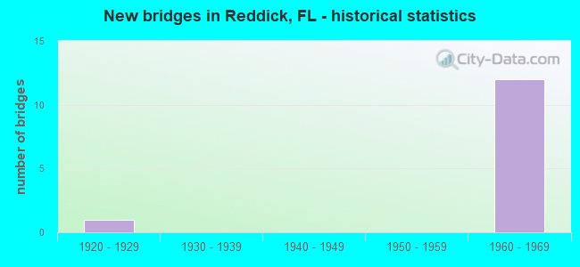
- New bridges - historical statistics
- 11920-1929
- 121960-1969

- Reconstructed bridges - Historical Statistics
- 11950-1959
- 01960-1969
- 01970-1979
- 01980-1989
- 21990-1999


Find on map >> Show street view
Structure Number: 360033, Location: CR-316 over I-75 (Lat: 29.366719, Lng: -82.226481), Route carried "on" structure: County highway 316, Year Built: 1964, Status: Open, Structure Length: 8.88m (29.13ft), Average Daily Traffic: 700 (year 2020), Truck Traffic: 8%, Average Future Daily Traffic: 1,215 (year 2042), Design Load: H 20, Features Intersected: I-75
Minimum Vertical Clearance: 30+ m (98+ ft), Kilometerpoint: 17.257, Lanes on structure: 2, Lanes under structure: 6, Owner: State Highway Agency, Approaching Roadway Width: 7.3m (24.0ft), Skew: 2 degrees, Material/Design: Prestressed concrete, Design/Construction: Stringer/Multi-beam, Number Of Spans In Main Unit: 4, Length of Maximum Span: 22.9m (75.1ft), Curb or Sidewalk Widths: Left: 0.6m (2.0ft), Right: 0.6m (2.0ft), Curb-To-Curb Width: 8.5m (27.9ft), Out-to-Out Width: 10.4m (34.1ft)
Condition: Deck: Good, Superstructure: Good, Substructure: Good, Operating Rating: 56.0 metric tons, Method Used To Determine Operating Rating: Load Factor (LF), Inventory Rating: 34.3 metric tons, Method Used To Determine Inventory Rating: Load Factor (LF), Structural Evaluation: Better than present minimum criteria, Deck Geometry: Somewhat better than minimum adequacy, Underclear: Meets minimum limits, Approach Roadway Alignment: Equal to present desirable criteria, Designated Inspection Frequency: Every 24 months, Inspection Date: May 2021, Deck Structure Type: Concrete Cast-file-Place
Find on map >> Show street view
Structure Number: 360035, Location: I-75 SB over CR-329 (Lat: 29.347842, Lng: -82.219417), Route carried "on" structure: Interstate 75, Year Built: 1964, Year Reconstructed: 1997, Status: Open, Structure Length: 5.04m (16.54ft), Average Daily Traffic: 30,750 (year 2020), Truck Traffic: 21%, Average Future Daily Traffic: 53,351 (year 2042), Design Load: HS 20+Mod, Features Intersected: CR-329
Minimum Vertical Clearance: 30+ m (98+ ft), Kilometerpoint: 44.852, Lanes on structure: 3, Lanes under structure: 2, Base Highway Network: Yes, Owner: State Highway Agency, Approaching Roadway Width: 17.3m (56.8ft), Skew: 3 degrees, Material/Design: Prestressed concrete, Design/Construction: Stringer/Multi-beam, Number Of Spans In Main Unit: 3, Length of Maximum Span: 18.6m (61.0ft), Curb-To-Curb Width: 17.3m (56.8ft), Out-to-Out Width: 18.3m (60.0ft)
Condition: Deck: Good, Superstructure: Good, Substructure: Good, Operating Rating: 57.7 metric tons, Method Used To Determine Operating Rating: Load Factor (LF), Inventory Rating: 34.7 metric tons, Method Used To Determine Inventory Rating: Load Factor (LF), Structural Evaluation: Better than present minimum criteria, Deck Geometry: Better than present minimum criteria, Underclear: Somewhat better than minimum adequacy, Approach Roadway Alignment: Equal to present desirable criteria, Designated Inspection Frequency: Every 24 months, Inspection Date: May 2021, Deck Structure Type: Concrete Cast-file-Place
Find on map >> Show street view
Structure Number: 360036, Location: I-75 NB OVER CR-329 (Lat: 29.347739, Lng: -82.219119), Route carried "on" structure: Interstate 75, Year Built: 1964, Year Reconstructed: 1997, Status: Open, Structure Length: 5.04m (16.54ft), Average Daily Traffic: 30,750 (year 2020), Truck Traffic: 21%, Average Future Daily Traffic: 53,351 (year 2042), Design Load: HS 20+Mod, Features Intersected: CR-329
Minimum Vertical Clearance: 30+ m (98+ ft), Kilometerpoint: 44.836, Lanes on structure: 3, Lanes under structure: 2, Base Highway Network: Yes, Owner: State Highway Agency, Approaching Roadway Width: 17.3m (56.8ft), Skew: 3 degrees, Material/Design: Prestressed concrete, Design/Construction: Stringer/Multi-beam, Number Of Spans In Main Unit: 3, Length of Maximum Span: 18.6m (61.0ft), Curb-To-Curb Width: 17.3m (56.8ft), Out-to-Out Width: 18.3m (60.0ft)
Condition: Deck: Good, Superstructure: Good, Substructure: Good, Operating Rating: 57.7 metric tons, Method Used To Determine Operating Rating: Load Factor (LF), Inventory Rating: 34.7 metric tons, Method Used To Determine Inventory Rating: Load Factor (LF), Structural Evaluation: Better than present minimum criteria, Deck Geometry: Better than present minimum criteria, Underclear: Somewhat better than minimum adequacy, Approach Roadway Alignment: Equal to present desirable criteria, Designated Inspection Frequency: Every 24 months, Inspection Date: May 2021, Deck Structure Type: Concrete Cast-file-Place
Find on map >> Show street view
Structure Number: 360042, Location: US-441 NB - US-301 SB (Lat: 29.342956, Lng: -82.150939), Route carried "on" structure: US 25, Year Built: 1964, Status: Open, Structure Length: 5.36m (17.59ft), Average Daily Traffic: 4,350 (year 2020), Truck Traffic: 16%, Average Future Daily Traffic: 7,547 (year 2042), Design Load: HS 20, Features Intersected: US-301 SB, Facility Carried by Structure: US-441 NB
Minimum Vertical Clearance: 30+ m (98+ ft), Kilometerpoint: 14.066, Lanes on structure: 2, Lanes under structure: 2, Base Highway Network: Yes, Owner: State Highway Agency, Approaching Roadway Width: 10.6m (34.8ft), Skew: 4 degrees, Material/Design: Prestressed concrete, Design/Construction: Stringer/Multi-beam, Number Of Spans In Main Unit: 3, Length of Maximum Span: 18.9m (62.0ft), Curb-To-Curb Width: 8.5m (27.9ft), Out-to-Out Width: 10.4m (34.1ft)
Condition: Deck: Good, Superstructure: Good, Substructure: Good, Operating Rating: 60.2 metric tons, Method Used To Determine Operating Rating: Load Factor (LF), Inventory Rating: 37.2 metric tons, Method Used To Determine Inventory Rating: Load Factor (LF), Structural Evaluation: Better than present minimum criteria, Deck Geometry: High priority of corrective action, Underclear: Meets minimum limits, Approach Roadway Alignment: Better than present minimum criteria, Designated Inspection Frequency: Every 24 months, Inspection Date: July 2021, Deck Structure Type: Concrete Cast-file-Place, Wearing Surface/Protective System: Wearing Surface: Monolithic Concrete
Find on map >> Show street view
Structure Number: 36091, Location: US-441SB - Abandoned RR (Lat: 29.398861, Lng: -82.201967), Route carried "on" structure: US 441, Year Built: 1964, Status: Open, Structure Length: 3.63m (11.91ft), Average Daily Traffic: 3,600 (year 2020), Truck Traffic: 2%, Average Future Daily Traffic: 6,246 (year 2042), Design Load: HS 20, Features Intersected: Abandoned RR
Minimum Vertical Clearance: 30+ m (98+ ft), Kilometerpoint: 22.138, Lanes on structure: 2, Owner: State Highway Agency, Approaching Roadway Width: 9.7m (31.8ft), Material/Design: Prestressed concrete, Design/Construction: Stringer/Multi-beam, Number Of Spans In Main Unit: 3, Length of Maximum Span: 11.9m (39.0ft), Curb-To-Curb Width: 8.5m (27.9ft), Out-to-Out Width: 10.3m (33.8ft)
Condition: Deck: Good, Superstructure: Good, Substructure: Good, Operating Rating: 64.8 metric tons, Method Used To Determine Operating Rating: Load Factor (LF), Inventory Rating: 41.3 metric tons, Method Used To Determine Inventory Rating: Load Factor (LF), Structural Evaluation: Better than present minimum criteria, Deck Geometry: High priority of corrective action, Approach Roadway Alignment: Equal to present desirable criteria, Designated Inspection Frequency: Every 24 months, Inspection Date: Febuary 2022, Deck Structure Type: Concrete Cast-file-Place, Wearing Surface/Protective System: Wearing Surface: Monolithic Concrete
Find on map >> Show street view
Structure Number: 360941, Location: US-441 NB - Abandoned RR (Lat: 29.399003, Lng: -82.201836), Route carried "on" structure: US 441, Year Built: 1964, Status: Open, Structure Length: 3.63m (11.91ft), Average Daily Traffic: 3,600 (year 2020), Truck Traffic: 2%, Average Future Daily Traffic: 6,246 (year 2042), Design Load: HS 20, Features Intersected: Abandoned RR
Minimum Vertical Clearance: 30+ m (98+ ft), Kilometerpoint: 22.138, Lanes on structure: 2, Owner: State Highway Agency, Approaching Roadway Width: 8.6m (28.2ft), Material/Design: Prestressed concrete, Design/Construction: Stringer/Multi-beam, Number Of Spans In Main Unit: 3, Length of Maximum Span: 11.9m (39.0ft), Curb-To-Curb Width: 8.4m (27.6ft), Out-to-Out Width: 10.4m (34.1ft)
Condition: Deck: Good, Superstructure: Good, Substructure: Good, Operating Rating: 64.8 metric tons, Method Used To Determine Operating Rating: Load Factor (LF), Inventory Rating: 41.3 metric tons, Method Used To Determine Inventory Rating: Load Factor (LF), Structural Evaluation: Better than present minimum criteria, Deck Geometry: High priority of corrective action, Approach Roadway Alignment: Equal to present desirable criteria, Designated Inspection Frequency: Every 24 months, Inspection Date: Febuary 2022, Deck Structure Type: Concrete Cast-file-Place, Wearing Surface/Protective System: Wearing Surface: Monolithic Concrete
Find on map >> Show street view
Structure Number: 360951, Location: NW 120th Street over I-75 (Lat: 29.323203, Lng: -82.212278), Route carried "on" structure: County highway 75, Year Built: 1964, Status: Open, Structure Length: 8.73m (28.64ft), Average Daily Traffic: 300 (year 2021), Truck Traffic: 7%, Average Future Daily Traffic: 521 (year 2042), Design Load: H 20, Features Intersected: I-75, Facility Carried by Structure: NW 120th Street
Minimum Vertical Clearance: 30+ m (98+ ft), Kilometerpoint: 3.545, Lanes on structure: 2, Lanes under structure: 6, Owner: State Highway Agency, Approaching Roadway Width: 6.9m (22.6ft), Skew: 1 degrees, Material/Design: Prestressed concrete, Design/Construction: Stringer/Multi-beam, Number Of Spans In Main Unit: 4, Length of Maximum Span: 21.9m (71.9ft), Curb or Sidewalk Widths: Left: 0.6m (2.0ft), Right: 0.6m (2.0ft), Curb-To-Curb Width: 8.6m (28.2ft), Out-to-Out Width: 10.4m (34.1ft)
Condition: Deck: Good, Superstructure: Good, Substructure: Good, Operating Rating: 74.0 metric tons, Method Used To Determine Operating Rating: Load Factor (LF), Inventory Rating: 44.4 metric tons, Method Used To Determine Inventory Rating: Load Factor (LF), Structural Evaluation: Better than present minimum criteria, Deck Geometry: Equal to present minimum criteria, Underclear: Meets minimum limits, Approach Roadway Alignment: Equal to present desirable criteria, Designated Inspection Frequency: Every 24 months, Inspection Date: May 2021, Deck Structure Type: Concrete Cast-file-Place
Find on map >> Show street view
Structure Number: 364002, Location: 3.9 miles North of SR-326 (Lat: 29.320694, Lng: -82.196667), Route carried "on" structure: Alternate County highway 25A, Year Built: 1925, Year Reconstructed: 1962, Status: Posted for load, Structure Length: 3.76m (12.34ft), Average Daily Traffic: 4,000 (year 2020), Truck Traffic: 10%, Average Future Daily Traffic: 6,940 (year 2042), Design Load: HS 20, Features Intersected: SCL Railroad
Minimum Vertical Clearance: 30+ m (98+ ft), Kilometerpoint: 17.096, Lanes on structure: 2, Owner: County Highway Agency, Approaching Roadway Width: 8.1m (26.6ft), Skew: 3 degrees, Material/Design: Concrete, Design/Construction: Tee Beam, Number Of Spans In Main Unit: 3, Length of Maximum Span: 12.6m (41.3ft), Curb or Sidewalk Widths: Left: 0.6m (2.0ft), Right: 0.6m (2.0ft), Curb-To-Curb Width: 8.5m (27.9ft), Out-to-Out Width: 10.4m (34.1ft)
Condition: Deck: Good, Superstructure: Good, Substructure: Good, Operating Rating: 26.4 metric tons, Method Used To Determine Operating Rating: Load Factor (LF), Inventory Rating: 15.8 metric tons, Method Used To Determine Inventory Rating: Load Factor (LF), Structural Evaluation: Meets minimum limits, Deck Geometry: Meets minimum limits, Underclear: Meets minimum limits, Approach Roadway Alignment: Equal to present desirable criteria, Bridge Posting: Required (Relationship of Operating Rating to Maximum Legal Load: 30.0 - 39.9% below), Designated Inspection Frequency: Every 24 months, Other Special Inspection Frequency: Every 12 months, Inspection Date: Febuary 2022, Other Special Inspection Date: Febuary 2022, Deck Structure Type: Concrete Cast-file-Place, Wearing Surface/Protective System: Wearing Surface: Bituminous
Find on map >> Show street view
Structure Number: 360033, Location: CR-316 over I-75 (Lat: 29.366719, Lng: -82.226481), Route carried "under" structure: Interstate 75, Year Built: 1964, Structure Length: 0. m, Average Daily Traffic: 61,500 (year 2020), Truck Traffic: 21%, Features Intersected: I-75, Facility Carried by Structure: CR-316
Minimum Vertical Clearance: 4.97m (16.31ft), Kilometerpoint: 47.123, Lanes on structure: 2, Lanes under structure: 6, Material/Design: Prestressed concrete, Design/Construction: Stringer/Multi-beam, Length of Maximum Span: 22.9m (75.1ft)
Find on map >> Show street view
Structure Number: 360035, Location: I-75 SB over CR-329 (Lat: 29.347842, Lng: -82.219417), Route carried "under" structure: County highway 329, Year Built: 1964, Structure Length: 0. m, Average Daily Traffic: 1,500 (year 2020), Truck Traffic: 8%, Features Intersected: CR-329, Facility Carried by Structure: I-75
Minimum Vertical Clearance: 4.79m (15.72ft), Kilometerpoint: 3.178, Lanes on structure: 3, Lanes under structure: 2, Material/Design: Prestressed concrete, Design/Construction: Stringer/Multi-beam, Length of Maximum Span: 18.6m (61.0ft)
Find on map >> Show street view
Structure Number: 360036, Location: I-75 NB OVER CR-329 (Lat: 29.347739, Lng: -82.219119), Route carried "under" structure: County highway 329, Year Built: 1964, Structure Length: 0. m, Average Daily Traffic: 1,500 (year 2020), Truck Traffic: 8%, Features Intersected: CR-329, Facility Carried by Structure: I-75
Minimum Vertical Clearance: 4.94m (16.21ft), Kilometerpoint: 3.143, Lanes on structure: 3, Lanes under structure: 2, Material/Design: Prestressed concrete, Design/Construction: Stringer/Multi-beam, Length of Maximum Span: 18.6m (61.0ft)
Find on map >> Show street view
Structure Number: 360042, Location: US-441 NB - US-301 SB (Lat: 29.342956, Lng: -82.150939), Route carried "under" structure: US 200, Year Built: 1964, Structure Length: 0. m, Average Daily Traffic: 7,350 (year 2020), Truck Traffic: 28%, Features Intersected: US-301 SB, Facility Carried by Structure: US-441 NB
Minimum Vertical Clearance: 5.15m (16.90ft), Kilometerpoint: 0.370, Lanes on structure: 2, Lanes under structure: 2, Material/Design: Prestressed concrete, Design/Construction: Stringer/Multi-beam, Length of Maximum Span: 18.9m (62.0ft)
Find on map >> Show street view
Structure Number: 360951, Location: NW 120th Street over I-75 (Lat: 29.323203, Lng: -82.212278), Route carried "under" structure: Interstate 93, Year Built: 1964, Structure Length: 0. m, Average Daily Traffic: 61,500 (year 2020), Truck Traffic: 21%, Features Intersected: I-75, Facility Carried by Structure: NW 120th Street
Minimum Vertical Clearance: 4.85m (15.91ft), Kilometerpoint: 42.089, Lanes on structure: 2, Lanes under structure: 6, Material/Design: Prestressed concrete, Design/Construction: Stringer/Multi-beam, Length of Maximum Span: 21.9m (71.9ft)