Bridge Statistics for Reamstown, Pennsylvania (PA)
Condition, Traffic, Stress, Structural Evaluation, Project Costs
- National Bridge Inventory (NBI) Statistics
- 23Number of bridges
- 174ft / 53.2mTotal length
- $2,411,000Total costs
- 224,532Total average daily traffic
- 38,310Total average daily truck traffic
- National Bridge Inventory (NBI) Registered Bridges for Reamstown
- No street view available for this location
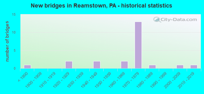
- New bridges - historical statistics
- 1Before 1900
- 21920-1929
- 21940-1949
- 21960-1969
- 131970-1979
- 11980-1989
- 12000-2009
- 12010-2019

- Reconstructed bridges - Historical Statistics
- 31960-1969
- 01970-1979
- 01980-1989
- 01990-1999
- 12000-2009


- Bridge Condition - Deck
- 7.1%Excellent
- 7.1%Very good
- 14.3%Good
- 50.0%Satisfactory
- 14.3%Fair
- 7.1%Poor

- Bridge Condition - Superstructure
- 7.1%Excellent
- 28.6%Good
- 28.6%Satisfactory
- 28.6%Fair
- 7.1%Poor

- Bridge Condition - Substructure
- 7.1%Excellent
- 35.7%Good
- 35.7%Satisfactory
- 14.3%Fair
- 7.1%Poor

- Bridge Condition - Channel
- 10.0%Very good
- 10.0%Good
- 20.0%Satisfactory
- 60.0%Fair
Find on map >> Show street view
Structure Number: 21105, Location: 0.75 MI.N.W. OF HAHNSTOWN (Lat: 40.181933, Lng: -76.131014), Route carried "on" structure: US 222, Year Built: 1970, Status: Open, Structure Length: 6.46m (21.19ft), Average Daily Traffic: 19,012 (year 2020), Truck Traffic: 19%, Average Future Daily Traffic: 21,568 (year 2032), Design Load: HS 20, Features Intersected: SR 1049; GLENWOOD RD
Minimum Vertical Clearance: 30+ m (98+ ft), Kilometerpoint: 68.338, Lanes on structure: 2, Lanes under structure: 2, Base Highway Network: Yes, Owner: State Highway Agency, Approaching Roadway Width: 11.6m (38.1ft), Skew: 10 degrees, Material/Design: Prestressed concrete, Design/Construction: Stringer/Multi-beam, Number Of Spans In Main Unit: 3, Length of Maximum Span: 25.9m (85.0ft), Curb or Sidewalk Widths: Left: 0.2m (0.7ft), Right: 0.2m (0.7ft), Curb-To-Curb Width: 12.0m (39.4ft), Out-to-Out Width: 13.2m (43.3ft)
Condition: Deck: Good, Superstructure: Satisfactory, Substructure: Good, Operating Rating: 66.2 metric tons, Method Used To Determine Operating Rating: Load Factor (LF), Inventory Rating: 27.2 metric tons, Method Used To Determine Inventory Rating: Load Factor (LF), Structural Evaluation: Equal to present minimum criteria, Deck Geometry: Equal to present minimum criteria, Underclear: Superior to present desirable criteria, Approach Roadway Alignment: Equal to present desirable criteria, Length Of Structure Improvement: 7.50m (24.61ft), Designated Inspection Frequency: Every 24 months, Inspection Date: June 2020, Deck Structure Type: Concrete Cast-file-Place, Wearing Surface/Protective System: Wearing Surface: Latex Concrete
Find on map >> Show street view
Structure Number: 21106, Location: 0.75 MI.N.W. OF HAHNSTOWN (Lat: 40.182317, Lng: -76.131242), Route carried "on" structure: US 222, Year Built: 1970, Status: Open, Structure Length: 5.39m (17.68ft), Average Daily Traffic: 19,535 (year 2020), Truck Traffic: 19%, Average Future Daily Traffic: 24,865 (year 2032), Design Load: HS 20, Features Intersected: SR 1049; GLENWOOD RD
Minimum Vertical Clearance: 30+ m (98+ ft), Kilometerpoint: 68.373, Lanes on structure: 2, Lanes under structure: 2, Base Highway Network: Yes, Owner: State Highway Agency, Approaching Roadway Width: 11.6m (38.1ft), Skew: 11 degrees, Material/Design: Prestressed concrete, Design/Construction: Stringer/Multi-beam, Number Of Spans In Main Unit: 3, Length of Maximum Span: 25.9m (85.0ft), Curb or Sidewalk Widths: Left: 0.2m (0.7ft), Right: 0.2m (0.7ft), Curb-To-Curb Width: 12.0m (39.4ft), Out-to-Out Width: 13.2m (43.3ft)
Condition: Deck: Very good, Superstructure: Good, Substructure: Satisfactory, Operating Rating: 62.6 metric tons, Method Used To Determine Operating Rating: Load Factor (LF), Inventory Rating: 28.1 metric tons, Method Used To Determine Inventory Rating: Load Factor (LF), Structural Evaluation: Equal to present minimum criteria, Deck Geometry: Equal to present minimum criteria, Underclear: Superior to present desirable criteria, Approach Roadway Alignment: Equal to present desirable criteria, Length Of Structure Improvement: 6.30m (20.67ft), Designated Inspection Frequency: Every 24 months, Inspection Date: June 2020, Deck Structure Type: Concrete Cast-file-Place, Wearing Surface/Protective System: Wearing Surface: Latex Concrete
Find on map >> Show street view
Structure Number: 21107, Location: S.E. Reamstown (Lat: 40.204525, Lng: -76.117775), Route carried "on" structure: US 222, Year Built: 1971, Status: Open, Structure Length: 7.74m (25.39ft), Average Daily Traffic: 19,012 (year 2020), Truck Traffic: 19%, Average Future Daily Traffic: 21,568 (year 2032), Design Load: HS 20, Features Intersected: SR1051 Church Street
Minimum Vertical Clearance: 30+ m (98+ ft), Kilometerpoint: 70.398, Lanes on structure: 2, Lanes under structure: 2, Base Highway Network: Yes, Owner: State Highway Agency, Approaching Roadway Width: 11.6m (38.1ft), Skew: 12 degrees, Material/Design: Prestressed concrete, Design/Construction: Stringer/Multi-beam, Number Of Spans In Main Unit: 3, Length of Maximum Span: 29.3m (96.1ft), Curb or Sidewalk Widths: Left: 0.2m (0.7ft), Right: 0.2m (0.7ft), Curb-To-Curb Width: 12.0m (39.4ft), Out-to-Out Width: 13.0m (42.7ft)
Condition: Deck: Satisfactory, Superstructure: Good, Substructure: Good, Operating Rating: 98.9 metric tons, Method Used To Determine Operating Rating: Load Factor (LF), Inventory Rating: 25.4 metric tons, Method Used To Determine Inventory Rating: Load Factor (LF), Structural Evaluation: Equal to present minimum criteria, Deck Geometry: Better than present minimum criteria, Underclear: Superior to present desirable criteria, Approach Roadway Alignment: Equal to present desirable criteria, Length Of Structure Improvement: 8.70m (28.54ft), Designated Inspection Frequency: Every 24 months, Inspection Date: June 2020, Deck Structure Type: Concrete Cast-file-Place, Wearing Surface/Protective System: Wearing Surface: Monolithic Concrete
Find on map >> Show street view
Structure Number: 21108, Location: .5 mi.S. of Reamstown (Lat: 40.204778, Lng: -76.117933), Route carried "on" structure: US 222, Year Built: 1971, Year Reconstructed: 2011, Status: Open, Structure Length: 8.35m (27.40ft), Average Daily Traffic: 19,535 (year 2020), Truck Traffic: 19%, Average Future Daily Traffic: 24,865 (year 2032), Design Load: HS 20, Features Intersected: SR 1051; Church St
Minimum Vertical Clearance: 30+ m (98+ ft), Kilometerpoint: 70.515, Lanes on structure: 2, Lanes under structure: 2, Base Highway Network: Yes, Owner: State Highway Agency, Approaching Roadway Width: 11.6m (38.1ft), Skew: 12 degrees, Material/Design: Prestressed concrete, Design/Construction: Stringer/Multi-beam, Number Of Spans In Main Unit: 3, Length of Maximum Span: 29.3m (96.1ft), Curb or Sidewalk Widths: Left: 0.2m (0.7ft), Right: 0.2m (0.7ft), Curb-To-Curb Width: 12.0m (39.4ft), Out-to-Out Width: 13.0m (42.7ft)
Condition: Deck: Good, Superstructure: Satisfactory, Substructure: Satisfactory, Operating Rating: 96.2 metric tons, Method Used To Determine Operating Rating: Load Factor (LF), Inventory Rating: 25.4 metric tons, Method Used To Determine Inventory Rating: Load Factor (LF), Structural Evaluation: Equal to present minimum criteria, Deck Geometry: Better than present minimum criteria, Underclear: Superior to present desirable criteria, Approach Roadway Alignment: Equal to present desirable criteria, Length Of Structure Improvement: 9.40m (30.84ft), Designated Inspection Frequency: Every 24 months, Inspection Date: June 2020, Deck Structure Type: Concrete Cast-file-Place, Wearing Surface/Protective System: Wearing Surface: Monolithic Concrete, Deck Protection: Epoxy Coated Reinforcing
Find on map >> Show street view
Structure Number: 21111, Location: 1.25 mi. E. of Reamstown (Lat: 40.214917, Lng: -76.094781), Route carried "on" structure: State highway , Year Built: 1972, Status: Open, Structure Length: 9.88m (32.41ft), Average Daily Traffic: 1,035 (year 2022), Truck Traffic: 2%, Average Future Daily Traffic: 992 (year 2032), Design Load: HS 20, Features Intersected: US 222; SR 0222, Facility Carried by Structure: Lausch Rd; T-963
Minimum Vertical Clearance: 30+ m (98+ ft), Kilometerpoint: 0.000, Lanes on structure: 2, Lanes under structure: 4, Owner: State Highway Agency, Approaching Roadway Width: 9.1m (29.9ft), Skew: 4 degrees, Material/Design: Steel, Design/Construction: Stringer/Multi-beam, Number Of Spans In Main Unit: 2, Number Of Approach Spans: 2, Length of Maximum Span: 35.1m (115.2ft), Curb or Sidewalk Widths: Left: 0.2m (0.7ft), Right: 0.2m (0.7ft), Curb-To-Curb Width: 12.8m (42.0ft), Out-to-Out Width: 14.0m (45.9ft)
Condition: Deck: Satisfactory, Superstructure: Fair, Substructure: Satisfactory, Operating Rating: 79.8 metric tons, Method Used To Determine Operating Rating: Load Factor (LF), Inventory Rating: 47.2 metric tons, Method Used To Determine Inventory Rating: Load Factor (LF), Structural Evaluation: Somewhat better than minimum adequacy, Deck Geometry: Better than present minimum criteria, Underclear: High priority of corrective action, Approach Roadway Alignment: Better than present minimum criteria, Length Of Structure Improvement: 10.90m (35.76ft), Designated Inspection Frequency: Every 24 months, Inspection Date: August 2020, Bridge Improvement Cost: $107,000, Roadway Improvement Cost: $316,000, Total Project Cost: $1,447,000, Deck Structure Type: Concrete Cast-file-Place, Wearing Surface/Protective System: Wearing Surface: Monolithic Concrete
Find on map >> Show street view
Structure Number: 21434, Location: 0.5 MI.N.E. OF REMANSTOWN (Lat: 40.216717, Lng: -76.128886), Route carried "on" structure: State highway , Year Built: 1962, Status: Open, Structure Length: 3.32m (10.89ft), Average Daily Traffic: 1,773 (year 2021), Truck Traffic: 5%, Average Future Daily Traffic: 1,826 (year 2032), Design Load: H 20, Features Intersected: COCALICO CREEK, Facility Carried by Structure: SR 1030
Minimum Vertical Clearance: 30+ m (98+ ft), Kilometerpoint: 2.017, Lanes on structure: 2, Owner: State Highway Agency, Approaching Roadway Width: 6.1m (20.0ft), Skew: 3 degrees, Material/Design: Prestressed concrete, Design/Construction: Box Beam or Girders - Multiple, Number Of Spans In Main Unit: 2, Length of Maximum Span: 16.5m (54.1ft), Curb or Sidewalk Widths: Left: 0.5m (1.6ft), Right: 0.5m (1.6ft), Curb-To-Curb Width: 8.5m (27.9ft), Out-to-Out Width: 10.2m (33.5ft)
Condition: Deck: Fair, Superstructure: Fair, Substructure: Satisfactory, Channel: Satisfactory, Operating Rating: 53.5 metric tons, Method Used To Determine Operating Rating: Load Factor (LF), Inventory Rating: 17.2 metric tons, Method Used To Determine Inventory Rating: Load Factor (LF), Structural Evaluation: Meets minimum limits, Deck Geometry: Somewhat better than minimum adequacy, Waterway Adequacy: Better than present minimum criteria, Approach Roadway Alignment: Equal to present desirable criteria, Length Of Structure Improvement: 4.20m (13.78ft), Designated Inspection Frequency: Every 24 months, Inspection Date: March 2021, Bridge Improvement Cost: $10,000, Roadway Improvement Cost: $30,000, Total Project Cost: $137,000, Deck Structure Type: Other, Wearing Surface/Protective System: Wearing Surface: Bituminous
Find on map >> Show street view
Structure Number: 2148, Location: REAMSTOWN (Lat: 40.212594, Lng: -76.124919), Route carried "on" structure: State highway , Year Built: 1969, Status: Open, Structure Length: 1.01m (3.31ft), Average Daily Traffic: 7,087 (year 2022), Truck Traffic: 6%, Average Future Daily Traffic: 9,446 (year 2032), Design Load: HS 20, Features Intersected: STONY RUN CREEK, Facility Carried by Structure: SR 1051
Minimum Vertical Clearance: 30+ m (98+ ft), Kilometerpoint: 8.352, Lanes on structure: 2, Owner: State Highway Agency, Approaching Roadway Width: 9.1m (29.9ft), Material/Design: Prestressed concrete, Design/Construction: Box Beam or Girders - Single/Spread, Number Of Spans In Main Unit: 1, Length of Maximum Span: 9.8m (32.2ft), Curb or Sidewalk Widths: Left: 1.5m (4.9ft), Right: 1.5m (4.9ft), Curb-To-Curb Width: 9.1m (29.9ft), Out-to-Out Width: 13.0m (42.7ft)
Condition: Deck: Satisfactory, Superstructure: Satisfactory, Substructure: Good, Channel: Good, Operating Rating: 71.7 metric tons, Method Used To Determine Operating Rating: Load Factor (LF), Inventory Rating: 38.1 metric tons, Method Used To Determine Inventory Rating: Load Factor (LF), Structural Evaluation: Equal to present minimum criteria, Deck Geometry: High priority of corrective action, Waterway Adequacy: Better than present minimum criteria, Approach Roadway Alignment: Equal to present desirable criteria, Length Of Structure Improvement: 1.80m (5.91ft), Designated Inspection Frequency: Every 24 months, Inspection Date: December 2020, Deck Structure Type: Concrete Cast-file-Place, Wearing Surface/Protective System: Wearing Surface: Monolithic Concrete
Find on map >> Show street view
Structure Number: 21791, Location: EAST COCALICO TWP (Lat: 40.225194, Lng: -76.102358), Route carried "on" structure: Interstate 76, Year Built: 1949, Status: Open, Structure Length: 0.79m (2.59ft), Average Daily Traffic: 24,971 (year 2001), Truck Traffic: 24%, Average Future Daily Traffic: 32,334 (year 2030), Design Load: HS 20, Features Intersected: STONY RUN
Minimum Vertical Clearance: 30+ m (98+ ft), Kilometerpoint: 0.000, Lanes on structure: 4, Base Highway Network: Yes, Toll: On toll road, Owner: State Toll Authority, Approaching Roadway Width: 23.8m (78.1ft), Skew: 31 degrees, Material/Design: Concrete, Design/Construction: Culvert, Number Of Spans In Main Unit: 1, Length of Maximum Span: 6.1m (20.0ft)
Condition: Channel: Fair, Culverts: Satisfactory, Operating Rating: 89.8 metric tons, Method Used To Determine Operating Rating: Load Factor (LF), Inventory Rating: 89.8 metric tons, Method Used To Determine Inventory Rating: Load Factor (LF), Structural Evaluation: Equal to present minimum criteria, Waterway Adequacy: Superior to present desirable criteria, Approach Roadway Alignment: Equal to present desirable criteria, Length Of Structure Improvement: 1.60m (5.25ft), Designated Inspection Frequency: Every 48 months, Inspection Date: March 2019
Find on map >> Show street view
Structure Number: 21844, Location: 2000 FT WEST OF SR 1059 (Lat: 40.203044, Lng: -76.089900), Route carried "on" structure: City street , Year Built: 1945, Year Reconstructed: 1966, Status: Posted for load, Structure Length: 1.04m (3.41ft), Average Daily Traffic: 310 (year 2012), Truck Traffic: 2%, Average Future Daily Traffic: 415 (year 2032), Features Intersected: LITTLE MUDDY CREEK, Facility Carried by Structure: T842 KRAMER MLL RD
Minimum Vertical Clearance: 30+ m (98+ ft), Kilometerpoint: 0.000, Lanes on structure: 2, Owner: Town or Township Highway Agency, Approaching Roadway Width: 5.8m (19.0ft), Skew: 2 degrees, Material/Design: Steel, Design/Construction: Stringer/Multi-beam, Number Of Spans In Main Unit: 1, Length of Maximum Span: 10.1m (33.1ft), Curb-To-Curb Width: 7.1m (23.3ft), Out-to-Out Width: 7.2m (23.6ft)
Condition: Deck: Satisfactory, Superstructure: Satisfactory, Substructure: Poor, Channel: Fair, Operating Rating: 29.0 metric tons, Method Used To Determine Operating Rating: Load Factor (LF), Inventory Rating: 17.2 metric tons, Method Used To Determine Inventory Rating: Load Factor (LF), Structural Evaluation: Meets minimum limits, Deck Geometry: Meets minimum limits, Waterway Adequacy: Equal to present desirable criteria, Approach Roadway Alignment: Meets minimum limits, Bridge Posting: Required (Relationship of Operating Rating to Maximum Legal Load: 30.0 - 39.9% below), Length Of Structure Improvement: 1.00m (3.28ft), Designated Inspection Frequency: Every 24 months, Other Special Inspection Frequency: Every 12 months, Inspection Date: March 2020, Other Special Inspection Date: March 2021, Bridge Improvement Cost: $9,000, Roadway Improvement Cost: $25,000, Total Project Cost: $117,000, Deck Structure Type: Concrete Cast-file-Place, Wearing Surface/Protective System: Wearing Surface: Bituminous
Find on map >> Show street view
Structure Number: 21891, Location: 600 FT SW OF SR 1051 (Lat: 40.210278, Lng: -76.124983), Route carried "on" structure: City street , Year Built: 1924, Year Reconstructed: 1960, Status: Open, Structure Length: 1.40m (4.59ft), Average Daily Traffic: 1,035 (year 2011), Truck Traffic: 10%, Average Future Daily Traffic: 1,385 (year 2031), Features Intersected: E BR STONY RUN, Facility Carried by Structure: T-700 REAMSTOWN RD
Minimum Vertical Clearance: 30+ m (98+ ft), Kilometerpoint: 0.000, Lanes on structure: 2, Owner: Town or Township Highway Agency, Approaching Roadway Width: 8.5m (27.9ft), Material/Design: Concrete, Design/Construction: Tee Beam, Number Of Spans In Main Unit: 2, Length of Maximum Span: 6.7m (22.0ft), Curb or Sidewalk Widths: Left: 0.0m, Right: 1.2m (3.9ft), Curb-To-Curb Width: 7.6m (24.9ft), Out-to-Out Width: 9.8m (32.2ft)
Condition: Deck: Poor, Superstructure: Fair, Substructure: Fair, Channel: Fair, Operating Rating: 78.0 metric tons, Method Used To Determine Operating Rating: Field evaluation and documented engineering judgment, Inventory Rating: 46.3 metric tons, Method Used To Determine Inventory Rating: Field evaluation and documented engineering judgment, Structural Evaluation: Somewhat better than minimum adequacy, Deck Geometry: Meets minimum limits, Waterway Adequacy: Better than present minimum criteria, Approach Roadway Alignment: Equal to present desirable criteria, Length Of Structure Improvement: 1.40m (4.59ft), Designated Inspection Frequency: Every 24 months, Inspection Date: June 2021, Bridge Improvement Cost: $19,000, Roadway Improvement Cost: $56,000, Total Project Cost: $258,000, Deck Structure Type: Concrete Cast-file-Place, Wearing Surface/Protective System: Wearing Surface: Bituminous
Find on map >> Show street view
Structure Number: 21892, Location: 900 FT SE OF SR 272 (Lat: 40.207522, Lng: -76.132567), Route carried "on" structure: City street , Year Built: 1925, Year Reconstructed: 1965, Status: Open, Structure Length: 0.85m (2.79ft), Average Daily Traffic: 310 (year 2011), Truck Traffic: 2%, Average Future Daily Traffic: 415 (year 2031), Features Intersected: STONY RUN, Facility Carried by Structure: COCALICO CREEK RD
Minimum Vertical Clearance: 30+ m (98+ ft), Kilometerpoint: 0.000, Lanes on structure: 2, Owner: Town or Township Highway Agency, Approaching Roadway Width: 4.6m (15.1ft), Skew: 3 degrees, Material/Design: Steel, Design/Construction: Stringer/Multi-beam, Number Of Spans In Main Unit: 1, Length of Maximum Span: 7.0m (23.0ft), Curb-To-Curb Width: 7.1m (23.3ft), Out-to-Out Width: 7.3m (24.0ft)
Condition: Deck: Fair, Superstructure: Poor, Substructure: Fair, Channel: Fair, Operating Rating: 52.6 metric tons, Method Used To Determine Operating Rating: Load Factor (LF), Inventory Rating: 31.8 metric tons, Method Used To Determine Inventory Rating: Load Factor (LF), Structural Evaluation: Meets minimum limits, Deck Geometry: Meets minimum limits, Waterway Adequacy: Equal to present minimum criteria, Approach Roadway Alignment: Equal to present minimum criteria, Length Of Structure Improvement: 0.80m (2.62ft), Designated Inspection Frequency: Every 24 months, Inspection Date: June 2021, Bridge Improvement Cost: $7,000, Roadway Improvement Cost: $21,000, Total Project Cost: $96,000, Deck Structure Type: Concrete Cast-file-Place, Wearing Surface/Protective System: Wearing Surface: Bituminous
Find on map >> Show street view
Structure Number: 21893, Location: 1500 FT EAST OF SR 272 (Lat: 40.208008, Lng: -76.134717), Route carried "on" structure: City street , Year Built: 1891, Status: Posted for load, Structure Length: 1.68m (5.51ft), Average Daily Traffic: 100 (year 2012), Average Future Daily Traffic: 110 (year 2032), Design Load: HS 20, Features Intersected: COCALICO CREEK, Facility Carried by Structure: COCALICO CREEK RD
Minimum Vertical Clearance: 3.20m (10.50ft), Kilometerpoint: 0.000, Lanes on structure: 1, Owner: County Highway Agency, Approaching Roadway Width: 6.1m (20.0ft), Material/Design: Wood or Timber, Design/Construction: Truss - Thru, Number Of Spans In Main Unit: 1, Length of Maximum Span: 16.5m (54.1ft), Curb-To-Curb Width: 4.0m (13.1ft), Out-to-Out Width: 5.1m (16.7ft)
Condition: Deck: Satisfactory, Superstructure: Fair, Substructure: Satisfactory, Channel: Fair, Operating Rating: 3.6 metric tons, Method Used To Determine Operating Rating: Allowable Stress (AS), Inventory Rating: 1.8 metric tons, Method Used To Determine Inventory Rating: Allowable Stress (AS), Structural Evaluation: High priority of replacement, Deck Geometry: High priority of replacement, Waterway Adequacy: Equal to present minimum criteria, Approach Roadway Alignment: Somewhat better than minimum adequacy, Bridge Posting: Required (Relationship of Operating Rating to Maximum Legal Load: > 39.9% below), Length Of Structure Improvement: 1.90m (6.23ft), Designated Inspection Frequency: Every 24 months, Other Special Inspection Frequency: Every 12 months, Inspection Date: May 2020, Other Special Inspection Date: May 2021, Bridge Improvement Cost: $26,000, Roadway Improvement Cost: $78,000, Total Project Cost: $356,000, Deck Structure Type: Wood or Timber
Find on map >> Show street view
Structure Number: 21952, Location: AT T-647 INTERSECTION (Lat: 40.170158, Lng: -76.105419), Route carried "on" structure: City street , Year Built: 1982, Status: Open, Structure Length: 2.62m (8.60ft), Average Daily Traffic: 680 (year 2012), Average Future Daily Traffic: 900 (year 2032), Design Load: HS 20+Mod, Features Intersected: MUDDY CREEK, Facility Carried by Structure: FRYSVILLE RD
Minimum Vertical Clearance: 30+ m (98+ ft), Kilometerpoint: 0.000, Lanes on structure: 2, Owner: County Highway Agency, Approaching Roadway Width: 8.5m (27.9ft), Skew: 1 degrees, Material/Design: Steel, Design/Construction: Stringer/Multi-beam, Number Of Spans In Main Unit: 1, Length of Maximum Span: 25.6m (84.0ft), Curb-To-Curb Width: 8.5m (27.9ft), Out-to-Out Width: 9.4m (30.8ft)
Condition: Deck: Satisfactory, Superstructure: Good, Substructure: Good, Channel: Fair, Operating Rating: 67.1 metric tons, Method Used To Determine Operating Rating: Load Factor (LF), Inventory Rating: 39.9 metric tons, Method Used To Determine Inventory Rating: Load Factor (LF), Structural Evaluation: Better than present minimum criteria, Deck Geometry: Somewhat better than minimum adequacy, Waterway Adequacy: Meets minimum limits, Approach Roadway Alignment: Equal to present desirable criteria, Length Of Structure Improvement: 3.40m (11.15ft), Designated Inspection Frequency: Every 24 months, Inspection Date: April 2020, Deck Structure Type: Concrete Cast-file-Place, Wearing Surface/Protective System: Wearing Surface: Monolithic Concrete, Deck Protection: Epoxy Coated Reinforcing
Find on map >> Show street view
Structure Number: 4092, Location: 1/4 MI.N. REAMSTOWN (Lat: 40.214306, Lng: -76.125342), Route carried "on" structure: State highway 272, Year Built: 2000, Status: Open, Structure Length: 0.85m (2.79ft), Average Daily Traffic: 14,351 (year 2022), Truck Traffic: 9%, Average Future Daily Traffic: 19,001 (year 2032), Design Load: HS 25 or greater, Features Intersected: STONY RUN
Minimum Vertical Clearance: 30+ m (98+ ft), Kilometerpoint: 59.325, Lanes on structure: 2, Owner: State Highway Agency, Approaching Roadway Width: 13.4m (44.0ft), Skew: 1 degrees, Material/Design: Prestressed concrete, Design/Construction: Box Beam or Girders - Single/Spread, Number Of Spans In Main Unit: 1, Length of Maximum Span: 7.3m (24.0ft), Curb or Sidewalk Widths: Left: 0.2m (0.7ft), Right: 0.2m (0.7ft), Curb-To-Curb Width: 13.4m (44.0ft), Out-to-Out Width: 14.3m (46.9ft)
Condition: Deck: Satisfactory, Superstructure: Good, Substructure: Good, Channel: Satisfactory, Operating Rating: 70.8 metric tons, Method Used To Determine Operating Rating: Load Factor (LF), Inventory Rating: 41.7 metric tons, Method Used To Determine Inventory Rating: Load Factor (LF), Structural Evaluation: Better than present minimum criteria, Deck Geometry: Equal to present minimum criteria, Waterway Adequacy: Superior to present desirable criteria, Approach Roadway Alignment: Equal to present desirable criteria, Length Of Structure Improvement: 1.50m (4.92ft), Designated Inspection Frequency: Every 24 months, Inspection Date: Febuary 2021, Deck Structure Type: Concrete Cast-file-Place, Wearing Surface/Protective System: Wearing Surface: Monolithic Concrete, Deck Protection: Epoxy Coated Reinforcing
Find on map >> Show street view
Structure Number: 54926, Location: 1 MI West of SR 272 (Lat: 40.224533, Lng: -76.111875), Route carried "on" structure: City street , Year Built: 2018, Status: Open, Structure Length: 1.86m (6.10ft), Average Daily Traffic: 5,832 (year 2016), Truck Traffic: 7%, Average Future Daily Traffic: 6,715 (year 2026), Design Load: HL 93, Features Intersected: Stony Run, Facility Carried by Structure: T-901 Denver Rd.
Minimum Vertical Clearance: 30+ m (98+ ft), Kilometerpoint: 0.000, Lanes on structure: 2, Owner: Town or Township Highway Agency, Approaching Roadway Width: 11.0m (36.1ft), Skew: 3 degrees, Material/Design: Prestressed concrete, Design/Construction: Tee Beam, Number Of Spans In Main Unit: 1, Length of Maximum Span: 17.7m (58.1ft), Curb or Sidewalk Widths: Left: 0.2m (0.7ft), Right: 0.2m (0.7ft), Curb-To-Curb Width: 11.7m (38.4ft), Out-to-Out Width: 12.7m (41.7ft)
Condition: Deck: Excellent, Superstructure: Excellent, Substructure: Excellent, Channel: Very good, Operating Rating: 60.9 metric tons, Method Used To Determine Operating Rating: Assigned ratings based on Load and Resistance Factor Design (LRFD) reported by rating factor (RF) using HL93 loadings, Inventory Rating: 39.9 metric tons, Method Used To Determine Inventory Rating: Assigned ratings based on Load and Resistance Factor Design (LRFD) reported by rating factor (RF) using HL93 loadings, Structural Evaluation: Superior to present desirable criteria, Deck Geometry: Somewhat better than minimum adequacy, Waterway Adequacy: Superior to present desirable criteria, Approach Roadway Alignment: Equal to present minimum criteria, Designated Inspection Frequency: Every 24 months, Inspection Date: June 2021, Deck Structure Type: Concrete Cast-file-Place, Wearing Surface/Protective System: Wearing Surface: Monolithic Concrete, Deck Protection: Epoxy Coated Reinforcing
Find on map >> Show street view
Structure Number: 21105, Location: 0.75 MI.N.W. OF HAHNSTOWN (Lat: 40.181933, Lng: -76.131014), Route carried "under" structure: State highway , Year Built: 1970, Structure Length: 0. m, Average Daily Traffic: 938 (year 2022), Truck Traffic: 7%, Features Intersected: SR 1049; GLENWOOD RD, Facility Carried by Structure: US 222 NB; SR 0222
Minimum Vertical Clearance: 9.20m (30.18ft), Kilometerpoint: 1.135, Lanes on structure: 2, Lanes under structure: 2, Material/Design: Prestressed concrete, Design/Construction: Stringer/Multi-beam, Length of Maximum Span: 25.9m (85.0ft)
Find on map >> Show street view
Structure Number: 21106, Location: 0.75 MI.N.W. OF HAHNSTOWN (Lat: 40.182317, Lng: -76.131242), Route carried "under" structure: State highway , Year Built: 1970, Structure Length: 0. m, Average Daily Traffic: 938 (year 2022), Truck Traffic: 7%, Features Intersected: SR 1049; GLENWOOD RD, Facility Carried by Structure: US 222 SB; SR 0222
Minimum Vertical Clearance: 6.20m (20.34ft), Kilometerpoint: 1.135, Lanes on structure: 2, Lanes under structure: 2, Material/Design: Prestressed concrete, Design/Construction: Stringer/Multi-beam, Length of Maximum Span: 25.9m (85.0ft)
Find on map >> Show street view
Structure Number: 21107, Location: S.E. Reamstown (Lat: 40.204525, Lng: -76.117775), Route carried "under" structure: State highway , Year Built: 1971, Structure Length: 0. m, Average Daily Traffic: 5,492 (year 2022), Truck Traffic: 5%, Features Intersected: SR1051 Church Street, Facility Carried by Structure: US 222 NB
Minimum Vertical Clearance: 8.79m (28.84ft), Kilometerpoint: 7.242, Lanes on structure: 2, Lanes under structure: 2, Material/Design: Prestressed concrete, Design/Construction: Stringer/Multi-beam, Length of Maximum Span: 29.3m (96.1ft)
Find on map >> Show street view
Structure Number: 21108, Location: .5 mi.S. of Reamstown (Lat: 40.204778, Lng: -76.117933), Route carried "under" structure: State highway , Year Built: 1971, Structure Length: 0. m, Average Daily Traffic: 5,492 (year 2022), Truck Traffic: 5%, Features Intersected: SR 1051; Church St, Facility Carried by Structure: US 222 SB; SR 0222
Minimum Vertical Clearance: 8.76m (28.74ft), Kilometerpoint: 7.242, Lanes on structure: 2, Lanes under structure: 2, Material/Design: Prestressed concrete, Design/Construction: Stringer/Multi-beam, Length of Maximum Span: 29.3m (96.1ft)
Find on map >> Show street view
Structure Number: 2111, Location: 1 MI. E. OF REAMSTOWN (Lat: 40.210181, Lng: -76.106375), Route carried "under" structure: US 222, Year Built: 1972, Structure Length: 0. m, Average Daily Traffic: 19,012 (year 2020), Truck Traffic: 19%, Features Intersected: US 222; SR 0222, Facility Carried by Structure: SR 1082; T-852
Minimum Vertical Clearance: 4.57m (14.99ft), Kilometerpoint: 71.460, Lanes on structure: 2, Lanes under structure: 4, Material/Design: Prestressed concrete, Design/Construction: Box Beam or Girders - Single/Spread, Length of Maximum Span: 25.9m (85.0ft)
Find on map >> Show street view
Structure Number: 2111, Location: 1 MI. E. OF REAMSTOWN (Lat: 40.210181, Lng: -76.106375), Route carried "under" structure: US 222, Year Built: 1972, Structure Length: 0. m, Average Daily Traffic: 19,535 (year 2020), Truck Traffic: 19%, Features Intersected: US 222; SR 0222, Facility Carried by Structure: SR 1082; T-852
Minimum Vertical Clearance: 4.54m (14.90ft), Kilometerpoint: 71.522, Lanes on structure: 2, Lanes under structure: 4, Material/Design: Prestressed concrete, Design/Construction: Box Beam or Girders - Single/Spread, Length of Maximum Span: 25.9m (85.0ft)
Find on map >> Show street view
Structure Number: 21111, Location: 1.25 mi. E. of Reamstown (Lat: 40.214917, Lng: -76.094781), Route carried "under" structure: US 222, Year Built: 1972, Structure Length: 0. m, Average Daily Traffic: 19,535 (year 2020), Truck Traffic: 19%, Features Intersected: US 222; SR 0222, Facility Carried by Structure: Lausch Rd; T-963
Minimum Vertical Clearance: 4.52m (14.83ft), Kilometerpoint: 72.573, Lanes on structure: 2, Lanes under structure: 2, Material/Design: Steel, Design/Construction: Stringer/Multi-beam, Length of Maximum Span: 35.1m (115.2ft)
Find on map >> Show street view
Structure Number: 21111, Location: 1.25 mi. E. of Reamstown (Lat: 40.214917, Lng: -76.094781), Route carried "under" structure: US 222, Year Built: 1972, Structure Length: 0. m, Average Daily Traffic: 19,012 (year 2020), Truck Traffic: 19%, Features Intersected: US 222; SR 0222, Facility Carried by Structure: Lausch Rd; T-963
Minimum Vertical Clearance: 4.47m (14.67ft), Kilometerpoint: 72.543, Lanes on structure: 2, Lanes under structure: 2, Material/Design: Steel, Design/Construction: Stringer/Multi-beam, Length of Maximum Span: 35.1m (115.2ft)