Bridge Statistics for Rawlins, Wyoming (WY)
Condition, Traffic, Stress, Structural Evaluation, Project Costs
- National Bridge Inventory (NBI) Statistics
- 28Number of bridges
- 413ft / 126mTotal length
- $440,000Total costs
- 162,217Total average daily traffic
- 79,638Total average daily truck traffic
- National Bridge Inventory (NBI) Registered Bridges for Rawlins
- No street view available for this location
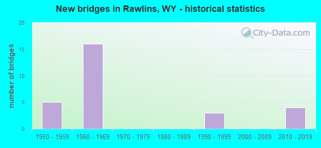
- New bridges - historical statistics
- 51950-1959
- 161960-1969
- 31990-1999
- 42010-2019
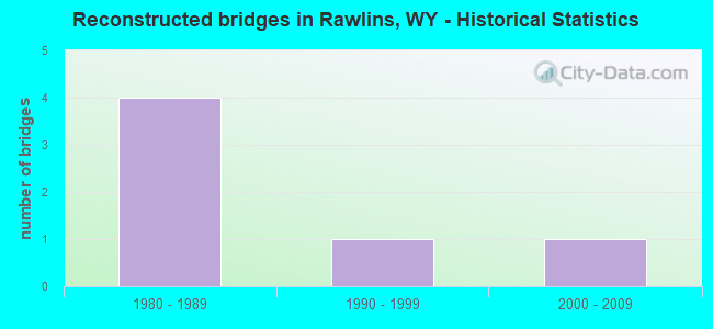
- Reconstructed bridges - Historical Statistics
- 41980-1989
- 11990-1999
- 12000-2009
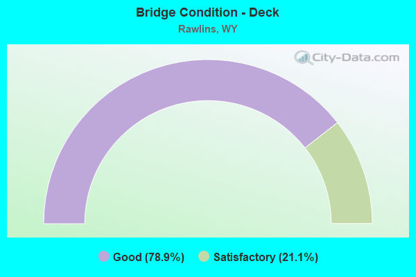
- Bridge Condition - Deck
- 78.9%Good
- 21.1%Satisfactory
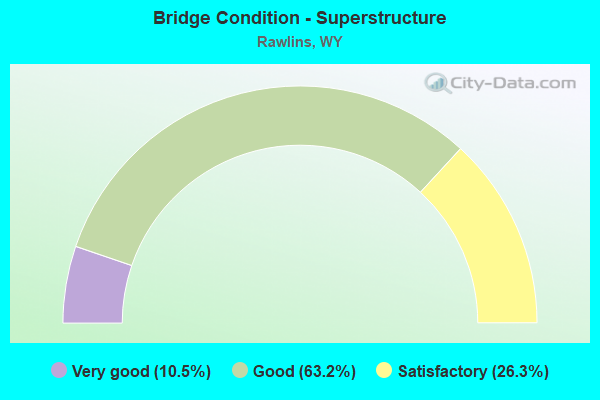
- Bridge Condition - Superstructure
- 10.5%Very good
- 63.2%Good
- 26.3%Satisfactory
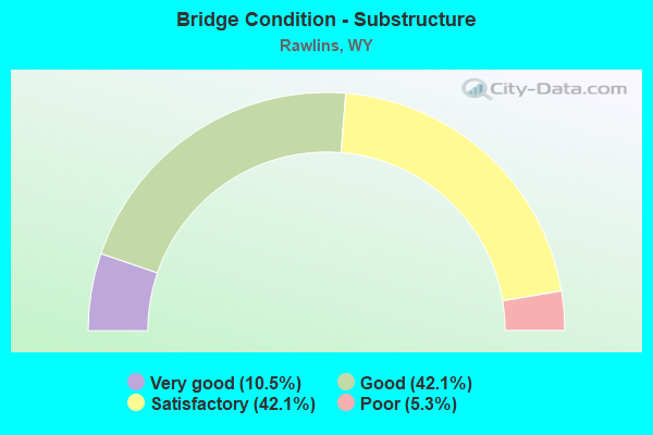
- Bridge Condition - Substructure
- 10.5%Very good
- 42.1%Good
- 42.1%Satisfactory
- 5.3%Poor
Find on map >> Show street view
Structure Number: ATJ, Location: Creston Jct - Rawlins (Lat: 41.775689, Lng: -107.327075), Route carried "on" structure: Interstate 80, Year Built: 1959, Status: Open, Structure Length: 2.45m (8.04ft), Average Daily Traffic: 6,767 (year 2021), Truck Traffic: 55%, Average Future Daily Traffic: 9,474 (year 2041), Design Load: HS 20+Mod, Features Intersected: 4 Mile Draw
Minimum Vertical Clearance: 30+ m (98+ ft), Kilometerpoint: 335.703, Lanes on structure: 2, Base Highway Network: Yes (Inventory Route: ML8, Subroute: 1), Owner: State Highway Agency, Approaching Roadway Width: 10.4m (34.1ft), Skew: 10 degrees, Material/Design: Concrete continuous, Design/Construction: Slab, Number Of Spans In Main Unit: 3, Length of Maximum Span: 9.1m (29.9ft), Curb-To-Curb Width: 11.6m (38.1ft), Out-to-Out Width: 12.5m (41.0ft)
Condition: Deck: Good, Superstructure: Good, Substructure: Satisfactory, Channel: Satisfactory, Operating Rating: 40.5 metric tons, Method Used To Determine Operating Rating: Load Factor (LF), Inventory Rating: 24.1 metric tons, Method Used To Determine Inventory Rating: Load Factor (LF), Structural Evaluation: Somewhat better than minimum adequacy, Deck Geometry: Equal to present minimum criteria, Waterway Adequacy: Equal to present desirable criteria, Approach Roadway Alignment: Equal to present desirable criteria, Designated Inspection Frequency: Every 24 months, Inspection Date: June 2020, Deck Structure Type: Concrete Cast-file-Place, Wearing Surface/Protective System: Wearing Surface: Bituminous, Membrane: Preformed Fabric
Find on map >> Show street view
Structure Number: ATK, Location: Creston Jct - Rawlins (Lat: 41.776114, Lng: -107.327017), Route carried "on" structure: Interstate 80, Year Built: 1959, Status: Open, Structure Length: 2.45m (8.04ft), Average Daily Traffic: 7,500 (year 2021), Truck Traffic: 44%, Average Future Daily Traffic: 10,500 (year 2041), Design Load: HS 20+Mod, Features Intersected: 4 Mile Draw
Minimum Vertical Clearance: 30+ m (98+ ft), Kilometerpoint: 335.484, Lanes on structure: 2, Base Highway Network: Yes (Inventory Route: ML8, Subroute: 1), Owner: State Highway Agency, Approaching Roadway Width: 10.4m (34.1ft), Skew: 10 degrees, Material/Design: Concrete continuous, Design/Construction: Slab, Number Of Spans In Main Unit: 3, Length of Maximum Span: 9.1m (29.9ft), Curb-To-Curb Width: 11.6m (38.1ft), Out-to-Out Width: 12.5m (41.0ft)
Condition: Deck: Good, Superstructure: Good, Substructure: Good, Channel: Satisfactory, Operating Rating: 40.5 metric tons, Method Used To Determine Operating Rating: Load Factor (LF), Inventory Rating: 24.1 metric tons, Method Used To Determine Inventory Rating: Load Factor (LF), Structural Evaluation: Somewhat better than minimum adequacy, Deck Geometry: Equal to present minimum criteria, Waterway Adequacy: Equal to present desirable criteria, Approach Roadway Alignment: Equal to present desirable criteria, Designated Inspection Frequency: Every 24 months, Inspection Date: June 2020, Deck Structure Type: Concrete Cast-file-Place, Wearing Surface/Protective System: Wearing Surface: Bituminous, Membrane: Preformed Fabric
Find on map >> Show street view
Structure Number: ATL, Location: Creston Jct - Rawlins (Lat: 41.776558, Lng: -107.311217), Route carried "on" structure: Interstate 80, Year Built: 1959, Status: Open, Structure Length: 2.65m (8.69ft), Average Daily Traffic: 6,767 (year 2021), Truck Traffic: 55%, Average Future Daily Traffic: 9,474 (year 2041), Design Load: HS 20+Mod, Features Intersected: Johnson Intg
Minimum Vertical Clearance: 30+ m (98+ ft), Kilometerpoint: 337.027, Lanes on structure: 2, Lanes under structure: 2, Base Highway Network: Yes (Inventory Route: ML8, Subroute: 1), Owner: State Highway Agency, Approaching Roadway Width: 11.6m (38.1ft), Skew: 10 degrees, Material/Design: Concrete continuous, Design/Construction: Slab, Number Of Spans In Main Unit: 3, Length of Maximum Span: 9.9m (32.5ft), Curb-To-Curb Width: 11.6m (38.1ft), Out-to-Out Width: 12.5m (41.0ft)
Condition: Deck: Satisfactory, Superstructure: Satisfactory, Substructure: Satisfactory, Operating Rating: 45.1 metric tons, Method Used To Determine Operating Rating: Load Factor (LF), Inventory Rating: 27.1 metric tons, Method Used To Determine Inventory Rating: Load Factor (LF), Structural Evaluation: Equal to present minimum criteria, Deck Geometry: Equal to present minimum criteria, Underclear: High priority of corrective action, Approach Roadway Alignment: Equal to present desirable criteria, Designated Inspection Frequency: Every 24 months, Inspection Date: May 2021, Deck Structure Type: Concrete Cast-file-Place, Wearing Surface/Protective System: Wearing Surface: Bituminous, Membrane: Preformed Fabric
Find on map >> Show street view
Structure Number: ATM, Location: Creston Jct - Rawlins (Lat: 41.776975, Lng: -107.311272), Route carried "on" structure: Interstate 80, Year Built: 1959, Status: Open, Structure Length: 2.65m (8.69ft), Average Daily Traffic: 7,500 (year 2021), Truck Traffic: 44%, Average Future Daily Traffic: 10,500 (year 2041), Design Load: HS 20+Mod, Features Intersected: Johnson Intg
Minimum Vertical Clearance: 30+ m (98+ ft), Kilometerpoint: 336.797, Lanes on structure: 2, Lanes under structure: 2, Base Highway Network: Yes (Inventory Route: ML8, Subroute: 1), Owner: State Highway Agency, Approaching Roadway Width: 11.6m (38.1ft), Skew: 10 degrees, Material/Design: Concrete continuous, Design/Construction: Slab, Number Of Spans In Main Unit: 3, Length of Maximum Span: 9.9m (32.5ft), Curb-To-Curb Width: 11.6m (38.1ft), Out-to-Out Width: 12.5m (41.0ft)
Condition: Deck: Satisfactory, Superstructure: Satisfactory, Substructure: Satisfactory, Operating Rating: 42.8 metric tons, Method Used To Determine Operating Rating: Load Factor (LF), Inventory Rating: 25.5 metric tons, Method Used To Determine Inventory Rating: Load Factor (LF), Structural Evaluation: Equal to present minimum criteria, Deck Geometry: Equal to present minimum criteria, Underclear: High priority of corrective action, Approach Roadway Alignment: Equal to present desirable criteria, Designated Inspection Frequency: Every 24 months, Inspection Date: May 2021, Deck Structure Type: Concrete Cast-file-Place, Wearing Surface/Protective System: Wearing Surface: Bituminous, Membrane: Preformed Fabric
Find on map >> Show street view
Structure Number: ATN, Location: Creston Jct - Rawlins (Lat: 41.778867, Lng: -107.282644), Route carried "on" structure: Interstate 80, Year Built: 1963, Status: Posted for load, Structure Length: 3.82m (12.53ft), Average Daily Traffic: 7,581 (year 2021), Truck Traffic: 51%, Average Future Daily Traffic: 10,613 (year 2041), Design Load: HS 20+Mod, Features Intersected: Two Mile Draw
Minimum Vertical Clearance: 30+ m (98+ ft), Kilometerpoint: 339.417, Lanes on structure: 2, Lanes under structure: 2, Base Highway Network: Yes (Inventory Route: ML8, Subroute: 1), Owner: State Highway Agency, Approaching Roadway Width: 11.6m (38.1ft), Skew: 10 degrees, Material/Design: Concrete continuous, Design/Construction: Slab, Number Of Spans In Main Unit: 4, Length of Maximum Span: 10.7m (35.1ft), Curb-To-Curb Width: 11.6m (38.1ft), Out-to-Out Width: 12.5m (41.0ft)
Condition: Deck: Satisfactory, Superstructure: Satisfactory, Substructure: Satisfactory, Operating Rating: 42.5 metric tons, Method Used To Determine Operating Rating: Load Factor (LF), Inventory Rating: 25.5 metric tons, Method Used To Determine Inventory Rating: Load Factor (LF), Structural Evaluation: Equal to present minimum criteria, Deck Geometry: Equal to present minimum criteria, Underclear: High priority of corrective action, Approach Roadway Alignment: Equal to present desirable criteria, Length Of Structure Improvement: 0.30m (0.98ft), Designated Inspection Frequency: Every 24 months, Inspection Date: May 2021, Bridge Improvement Cost: $1,000, Roadway Improvement Cost: $1,000, Total Project Cost: $3,000, Deck Structure Type: Concrete Cast-file-Place, Wearing Surface/Protective System: Wearing Surface: Epoxy Overlay
Find on map >> Show street view
Structure Number: ATO, Location: Creston Jct - Rawlins (Lat: 41.779233, Lng: -107.282708), Route carried "on" structure: Interstate 80, Year Built: 1963, Status: Posted for load, Structure Length: 3.82m (12.53ft), Average Daily Traffic: 7,722 (year 2021), Truck Traffic: 44%, Average Future Daily Traffic: 10,811 (year 2041), Design Load: HS 20+Mod, Features Intersected: Two Mile Draw
Minimum Vertical Clearance: 30+ m (98+ ft), Kilometerpoint: 339.185, Lanes on structure: 2, Lanes under structure: 2, Base Highway Network: Yes (Inventory Route: ML8, Subroute: 1), Owner: State Highway Agency, Approaching Roadway Width: 11.6m (38.1ft), Skew: 10 degrees, Material/Design: Concrete continuous, Design/Construction: Slab, Number Of Spans In Main Unit: 4, Length of Maximum Span: 10.7m (35.1ft), Curb-To-Curb Width: 11.6m (38.1ft), Out-to-Out Width: 12.5m (41.0ft)
Condition: Deck: Good, Superstructure: Good, Substructure: Satisfactory, Operating Rating: 42.8 metric tons, Method Used To Determine Operating Rating: Load Factor (LF), Inventory Rating: 25.5 metric tons, Method Used To Determine Inventory Rating: Load Factor (LF), Structural Evaluation: Equal to present minimum criteria, Deck Geometry: Equal to present minimum criteria, Underclear: High priority of corrective action, Approach Roadway Alignment: Equal to present desirable criteria, Designated Inspection Frequency: Every 24 months, Inspection Date: May 2021, Deck Structure Type: Concrete Cast-file-Place, Wearing Surface/Protective System: Wearing Surface: Epoxy Overlay
Find on map >> Show street view
Structure Number: ATQ, Location: Rawlins (Lat: 41.781017, Lng: -107.257283), Route carried "on" structure: Interstate 80, Year Built: 1962, Year Reconstructed: 1991, Status: Open, Structure Length: 5.85m (19.19ft), Average Daily Traffic: 7,000 (year 2021), Truck Traffic: 51%, Average Future Daily Traffic: 9,800 (year 2041), Design Load: HS 20+Mod, Features Intersected: UPRR
Minimum Vertical Clearance: 30+ m (98+ ft), Kilometerpoint: 341.590, Lanes on structure: 2, Base Highway Network: Yes (Inventory Route: ML8, Subroute: 1), Owner: State Highway Agency, Approaching Roadway Width: 11.0m (36.1ft), Skew: 12 degrees, Material/Design: Steel continuous, Design/Construction: Stringer/Multi-beam, Number Of Spans In Main Unit: 3, Length of Maximum Span: 26.8m (87.9ft), Curb-To-Curb Width: 12.2m (40.0ft), Out-to-Out Width: 13.0m (42.7ft)
Condition: Deck: Good, Superstructure: Good, Substructure: Satisfactory, Operating Rating: 53.5 metric tons, Method Used To Determine Operating Rating: Load Factor (LF), Inventory Rating: 31.8 metric tons, Method Used To Determine Inventory Rating: Load Factor (LF), Structural Evaluation: Equal to present minimum criteria, Deck Geometry: Better than present minimum criteria, Underclear: Better than present minimum criteria, Approach Roadway Alignment: Equal to present desirable criteria, Designated Inspection Frequency: Every 24 months, Inspection Date: May 2021, Deck Structure Type: Concrete Cast-file-Place, Wearing Surface/Protective System: Wearing Surface: Latex Concrete
Find on map >> Show street view
Structure Number: ATR, Location: Rawlins (Lat: 41.781161, Lng: -107.257106), Route carried "on" structure: Interstate 80, Year Built: 1962, Year Reconstructed: 1990, Status: Open, Structure Length: 5.85m (19.19ft), Average Daily Traffic: 7,500 (year 2021), Truck Traffic: 44%, Average Future Daily Traffic: 10,500 (year 2041), Design Load: HS 20+Mod, Features Intersected: UPRR
Minimum Vertical Clearance: 30+ m (98+ ft), Kilometerpoint: 341.377, Lanes on structure: 2, Base Highway Network: Yes (Inventory Route: ML8, Subroute: 1), Owner: State Highway Agency, Approaching Roadway Width: 12.2m (40.0ft), Skew: 12 degrees, Material/Design: Steel continuous, Design/Construction: Stringer/Multi-beam, Number Of Spans In Main Unit: 3, Length of Maximum Span: 26.5m (86.9ft), Curb-To-Curb Width: 12.2m (40.0ft), Out-to-Out Width: 13.0m (42.7ft)
Condition: Deck: Good, Superstructure: Good, Substructure: Good, Operating Rating: 53.5 metric tons, Method Used To Determine Operating Rating: Load Factor (LF), Inventory Rating: 31.8 metric tons, Method Used To Determine Inventory Rating: Load Factor (LF), Structural Evaluation: Better than present minimum criteria, Deck Geometry: Better than present minimum criteria, Underclear: Better than present minimum criteria, Approach Roadway Alignment: Equal to present desirable criteria, Designated Inspection Frequency: Every 24 months, Inspection Date: May 2021, Deck Structure Type: Concrete Cast-file-Place, Wearing Surface/Protective System: Wearing Surface: Latex Concrete
Find on map >> Show street view
Structure Number: ATS, Location: Rawlins (Lat: 41.778986, Lng: -107.251258), Route carried "on" structure: Interstate 80, Year Built: 1963, Year Reconstructed: 1991, Status: Open, Structure Length: 4.21m (13.81ft), Average Daily Traffic: 7,000 (year 2021), Truck Traffic: 51%, Average Future Daily Traffic: 9,800 (year 2041), Design Load: HS 20+Mod, Features Intersected: WYO 71
Minimum Vertical Clearance: 30+ m (98+ ft), Kilometerpoint: 342.140, Lanes on structure: 2, Lanes under structure: 2, Base Highway Network: Yes (Inventory Route: ML8, Subroute: 1), Owner: State Highway Agency, Approaching Roadway Width: 11.6m (38.1ft), Skew: 13 degrees, Material/Design: Concrete continuous, Design/Construction: Tee Beam, Number Of Spans In Main Unit: 3, Length of Maximum Span: 16.6m (54.5ft), Curb-To-Curb Width: 11.6m (38.1ft), Out-to-Out Width: 12.5m (41.0ft)
Condition: Deck: Good, Superstructure: Good, Substructure: Good, Operating Rating: 50.8 metric tons, Method Used To Determine Operating Rating: Load Factor (LF), Inventory Rating: 29.9 metric tons, Method Used To Determine Inventory Rating: Load Factor (LF), Structural Evaluation: Better than present minimum criteria, Deck Geometry: Equal to present minimum criteria, Underclear: Somewhat better than minimum adequacy, Approach Roadway Alignment: Equal to present desirable criteria, Designated Inspection Frequency: Every 24 months, Inspection Date: May 2021, Deck Structure Type: Concrete Cast-file-Place, Wearing Surface/Protective System: Wearing Surface: Latex Concrete
Find on map >> Show street view
Structure Number: ATT, Location: Rawlins (Lat: 41.779117, Lng: -107.251011), Route carried "on" structure: Interstate 80, Year Built: 1963, Status: Open, Structure Length: 4.21m (13.81ft), Average Daily Traffic: 7,500 (year 2021), Truck Traffic: 44%, Average Future Daily Traffic: 10,500 (year 2041), Design Load: HS 20+Mod, Features Intersected: WYO 71
Minimum Vertical Clearance: 30+ m (98+ ft), Kilometerpoint: 341.932, Lanes on structure: 2, Lanes under structure: 2, Base Highway Network: Yes (Inventory Route: ML8, Subroute: 1), Owner: State Highway Agency, Approaching Roadway Width: 11.6m (38.1ft), Skew: 13 degrees, Material/Design: Concrete continuous, Design/Construction: Tee Beam, Number Of Spans In Main Unit: 3, Length of Maximum Span: 16.6m (54.5ft), Curb-To-Curb Width: 11.6m (38.1ft), Out-to-Out Width: 12.5m (41.0ft)
Condition: Deck: Good, Superstructure: Good, Substructure: Good, Operating Rating: 50.8 metric tons, Method Used To Determine Operating Rating: Load Factor (LF), Inventory Rating: 29.9 metric tons, Method Used To Determine Inventory Rating: Load Factor (LF), Structural Evaluation: Better than present minimum criteria, Deck Geometry: Equal to present minimum criteria, Underclear: Somewhat better than minimum adequacy, Approach Roadway Alignment: Equal to present desirable criteria, Designated Inspection Frequency: Every 24 months, Inspection Date: May 2021, Deck Structure Type: Concrete Cast-file-Place, Wearing Surface/Protective System: Wearing Surface: Latex Concrete
Find on map >> Show street view
Structure Number: ATU, Location: Rawlins (Lat: 41.778503, Lng: -107.224708), Route carried "on" structure: State highway 78, Year Built: 1963, Status: Open, Structure Length: 5.91m (19.39ft), Average Daily Traffic: 4,109 (year 2021), Truck Traffic: 6%, Average Future Daily Traffic: 5,753 (year 2041), Design Load: HS 20, Features Intersected: I-80
Minimum Vertical Clearance: 30+ m (98+ ft), Kilometerpoint: 0.214, Lanes on structure: 2, Lanes under structure: 4, Owner: State Highway Agency, Approaching Roadway Width: 8.6m (28.2ft), Skew: 1 degrees, Material/Design: Concrete continuous, Design/Construction: Tee Beam, Number Of Spans In Main Unit: 4, Length of Maximum Span: 17.5m (57.4ft), Curb-To-Curb Width: 8.5m (27.9ft), Out-to-Out Width: 9.4m (30.8ft)
Condition: Deck: Good, Superstructure: Good, Substructure: Good, Operating Rating: 47.2 metric tons, Method Used To Determine Operating Rating: Load Factor (LF), Inventory Rating: 28.1 metric tons, Method Used To Determine Inventory Rating: Load Factor (LF), Structural Evaluation: Better than present minimum criteria, Deck Geometry: Meets minimum limits, Underclear: High priority of corrective action, Approach Roadway Alignment: Equal to present desirable criteria, Length Of Structure Improvement: 5.91m (19.39ft), Designated Inspection Frequency: Every 24 months, Inspection Date: May 2021, Bridge Improvement Cost: $281,000, Roadway Improvement Cost: $28,000, Total Project Cost: $422,000 ( Estimate for 2014), Deck Structure Type: Concrete Cast-file-Place, Wearing Surface/Protective System: Wearing Surface: Latex Concrete
Find on map >> Show street view
Structure Number: ATV, Location: Rawlins (Lat: 41.786117, Lng: -107.206697), Route carried "on" structure: Interstate 80, Year Built: 1963, Year Reconstructed: 1991, Status: Open, Structure Length: 1.86m (6.10ft), Average Daily Traffic: 7,000 (year 2021), Truck Traffic: 95%, Average Future Daily Traffic: 9,800 (year 2041), Design Load: HS 20+Mod, Features Intersected: Machinery Pass
Minimum Vertical Clearance: 3.98m (13.06ft), Kilometerpoint: 346.114, Lanes on structure: 2, Base Highway Network: Yes (Inventory Route: ML8, Subroute: 1), Owner: State Highway Agency, Approaching Roadway Width: 11.6m (38.1ft), Skew: 10 degrees, Material/Design: Concrete continuous, Design/Construction: Slab, Number Of Spans In Main Unit: 3, Length of Maximum Span: 7.6m (24.9ft), Curb-To-Curb Width: 11.6m (38.1ft), Out-to-Out Width: 12.5m (41.0ft)
Condition: Deck: Good, Superstructure: Good, Substructure: Satisfactory, Operating Rating: 46.1 metric tons, Method Used To Determine Operating Rating: Load Factor (LF), Inventory Rating: 27.4 metric tons, Method Used To Determine Inventory Rating: Load Factor (LF), Structural Evaluation: Equal to present minimum criteria, Deck Geometry: Equal to present minimum criteria, Approach Roadway Alignment: Equal to present desirable criteria, Designated Inspection Frequency: Every 24 months, Inspection Date: May 2021, Deck Structure Type: Concrete Cast-file-Place, Wearing Surface/Protective System: Wearing Surface: Latex Concrete
Find on map >> Show street view
Structure Number: ATW, Location: Rawlins (Lat: 41.786267, Lng: -107.206831), Route carried "on" structure: Interstate 80, Year Built: 1963, Status: Open, Structure Length: 1.86m (6.10ft), Average Daily Traffic: 7,500 (year 2021), Truck Traffic: 44%, Average Future Daily Traffic: 10,500 (year 2041), Design Load: HS 20+Mod, Features Intersected: Machinery Pass
Minimum Vertical Clearance: 30+ m (98+ ft), Kilometerpoint: 345.871, Lanes on structure: 2, Base Highway Network: Yes (Inventory Route: ML8, Subroute: 1), Owner: State Highway Agency, Approaching Roadway Width: 11.6m (38.1ft), Skew: 10 degrees, Material/Design: Concrete continuous, Design/Construction: Slab, Number Of Spans In Main Unit: 3, Length of Maximum Span: 7.6m (24.9ft), Curb-To-Curb Width: 11.6m (38.1ft), Out-to-Out Width: 12.5m (41.0ft)
Condition: Deck: Satisfactory, Superstructure: Satisfactory, Substructure: Satisfactory, Operating Rating: 46.1 metric tons, Method Used To Determine Operating Rating: Load Factor (LF), Inventory Rating: 27.4 metric tons, Method Used To Determine Inventory Rating: Load Factor (LF), Structural Evaluation: Equal to present minimum criteria, Deck Geometry: Equal to present minimum criteria, Approach Roadway Alignment: Equal to present desirable criteria, Designated Inspection Frequency: Every 24 months, Inspection Date: May 2021, Deck Structure Type: Concrete Cast-file-Place, Wearing Surface/Protective System: Wearing Surface: Latex Concrete
Find on map >> Show street view
Structure Number: ATX, Location: Rawlins (Lat: 41.787386, Lng: -107.204178), Route carried "on" structure: Interstate 80, Year Built: 1963, Year Reconstructed: 1991, Status: Open, Structure Length: 6.46m (21.19ft), Average Daily Traffic: 7,000 (year 2021), Truck Traffic: 95%, Average Future Daily Traffic: 9,800 (year 2041), Design Load: HS 20+Mod, Features Intersected: UPRR
Minimum Vertical Clearance: 30+ m (98+ ft), Kilometerpoint: 346.366, Lanes on structure: 2, Base Highway Network: Yes (Inventory Route: ML8, Subroute: 1), Owner: State Highway Agency, Approaching Roadway Width: 12.2m (40.0ft), Skew: 13 degrees, Material/Design: Steel continuous, Design/Construction: Stringer/Multi-beam, Number Of Spans In Main Unit: 3, Length of Maximum Span: 28.0m (91.9ft), Curb-To-Curb Width: 12.2m (40.0ft), Out-to-Out Width: 13.0m (42.7ft)
Condition: Deck: Good, Superstructure: Good, Substructure: Good, Operating Rating: 58.1 metric tons, Method Used To Determine Operating Rating: Load Factor (LF), Inventory Rating: 34.5 metric tons, Method Used To Determine Inventory Rating: Load Factor (LF), Structural Evaluation: Better than present minimum criteria, Deck Geometry: Better than present minimum criteria, Underclear: Meets minimum limits, Approach Roadway Alignment: Equal to present desirable criteria, Designated Inspection Frequency: Every 24 months, Inspection Date: May 2021, Deck Structure Type: Concrete Cast-file-Place, Wearing Surface/Protective System: Wearing Surface: Latex Concrete
Find on map >> Show street view
Structure Number: ATY, Location: Rawlins (Lat: 41.787475, Lng: -107.204492), Route carried "on" structure: Interstate 80, Year Built: 1963, Status: Open, Structure Length: 6.46m (21.19ft), Average Daily Traffic: 7,500 (year 2021), Truck Traffic: 44%, Average Future Daily Traffic: 10,500 (year 2041), Design Load: HS 20+Mod, Features Intersected: UPRR
Minimum Vertical Clearance: 30+ m (98+ ft), Kilometerpoint: 346.106, Lanes on structure: 2, Base Highway Network: Yes (Inventory Route: ML8, Subroute: 1), Owner: State Highway Agency, Approaching Roadway Width: 11.0m (36.1ft), Skew: 13 degrees, Material/Design: Steel continuous, Design/Construction: Stringer/Multi-beam, Number Of Spans In Main Unit: 3, Length of Maximum Span: 28.0m (91.9ft), Curb-To-Curb Width: 12.9m (42.3ft), Out-to-Out Width: 13.6m (44.6ft)
Condition: Deck: Good, Superstructure: Good, Substructure: Good, Operating Rating: 55.3 metric tons, Method Used To Determine Operating Rating: Load Factor (LF), Inventory Rating: 33.6 metric tons, Method Used To Determine Inventory Rating: Load Factor (LF), Structural Evaluation: Better than present minimum criteria, Deck Geometry: Superior to present desirable criteria, Underclear: Meets minimum limits, Approach Roadway Alignment: Equal to present desirable criteria, Designated Inspection Frequency: Every 24 months, Inspection Date: May 2021, Deck Structure Type: Concrete Cast-file-Place, Wearing Surface/Protective System: Wearing Surface: Latex Concrete
Find on map >> Show street view
Structure Number: CLV, Location: 6Th Street Rawlins (Lat: 41.784164, Lng: -107.239972), Route carried "on" structure: State highway 71, Year Built: 1966, Year Reconstructed: 2006, Status: Open, Structure Length: 44.78m (146.92ft), Average Daily Traffic: 2,153 (year 2021), Truck Traffic: 2%, Average Future Daily Traffic: 3,014 (year 2041), Design Load: HS 20, Features Intersected: UPRR, Facility Carried by Structure: S. 6th Street
Minimum Vertical Clearance: 30+ m (98+ ft), Kilometerpoint: 160.661, Lanes on structure: 2, Owner: Town or Township Highway Agency, Approaching Roadway Width: 10.4m (34.1ft), Material/Design: Steel continuous, Design/Construction: Stringer/Multi-beam, Number Of Spans In Main Unit: 6, Number Of Approach Spans: 5, Length of Maximum Span: 41.1m (134.8ft), Curb-To-Curb Width: 10.4m (34.1ft), Out-to-Out Width: 11.4m (37.4ft)
Condition: Deck: Good, Superstructure: Satisfactory, Substructure: Poor, Operating Rating: 47.2 metric tons, Method Used To Determine Operating Rating: Allowable Stress (AS), Inventory Rating: 33.6 metric tons, Method Used To Determine Inventory Rating: Allowable Stress (AS), Structural Evaluation: Meets minimum limits, Deck Geometry: Somewhat better than minimum adequacy, Underclear: Meets minimum limits, Approach Roadway Alignment: Equal to present minimum criteria, Length Of Structure Improvement: 6.10m (20.01ft), Designated Inspection Frequency: Every 24 months, Inspection Date: May 2021, Bridge Improvement Cost: $10,000, Roadway Improvement Cost: $1,000, Total Project Cost: $15,000, Deck Structure Type: Concrete Cast-file-Place, Wearing Surface/Protective System: Wearing Surface: Epoxy Overlay, Deck Protection: Epoxy Coated Reinforcing
Find on map >> Show street view
Structure Number: IYI, Location: Johnson Rd Int/Spruce Int (Lat: 41.781400, Lng: -107.267539), Route carried "on" structure: US 54, Year Built: 1994, Status: Open, Structure Length: 9.54m (31.30ft), Average Daily Traffic: 3,178 (year 2021), Truck Traffic: 14%, Average Future Daily Traffic: 4,449 (year 2041), Design Load: HS 20, Features Intersected: I-80, Facility Carried by Structure: I-80 Bus.
Minimum Vertical Clearance: 30+ m (98+ ft), Kilometerpoint: 340.708, Lanes on structure: 2, Lanes under structure: 4, Base Highway Network: Yes, Owner: State Highway Agency, Approaching Roadway Width: 16.5m (54.1ft), Skew: 3 degrees, Material/Design: Steel continuous, Design/Construction: Stringer/Multi-beam, Number Of Spans In Main Unit: 4, Length of Maximum Span: 30.2m (99.1ft), Curb or Sidewalk Widths: Left: 0.0m, Right: 1.5m (4.9ft), Curb-To-Curb Width: 15.8m (51.8ft), Out-to-Out Width: 18.4m (60.4ft)
Condition: Deck: Good, Superstructure: Good, Substructure: Good, Operating Rating: 68.0 metric tons, Method Used To Determine Operating Rating: Load Factor (LF), Inventory Rating: 40.8 metric tons, Method Used To Determine Inventory Rating: Load Factor (LF), Structural Evaluation: Better than present minimum criteria, Deck Geometry: Superior to present desirable criteria, Underclear: Equal to present minimum criteria, Approach Roadway Alignment: Better than present minimum criteria, Designated Inspection Frequency: Every 24 months, Inspection Date: May 2021, Deck Structure Type: Concrete Cast-file-Place
Find on map >> Show street view
Structure Number: MFQ, Location: Cedar Street Interchange (Lat: 41.788964, Lng: -107.200617), Route carried "on" structure: Interstate 80, Year Built: 2010, Status: Open, Structure Length: 5.49m (18.01ft), Average Daily Traffic: 7,000 (year 2021), Truck Traffic: 95%, Average Future Daily Traffic: 9,800 (year 2041), Design Load: HL 93, Features Intersected: East Cedar Street
Minimum Vertical Clearance: 30+ m (98+ ft), Kilometerpoint: 346.711, Lanes on structure: 2, Lanes under structure: 4, Base Highway Network: Yes (Inventory Route: ML8, Subroute: 1), Owner: State Highway Agency, Approaching Roadway Width: 11.6m (38.1ft), Skew: 13 degrees, Material/Design: Steel continuous, Design/Construction: Stringer/Multi-beam, Number Of Spans In Main Unit: 3, Length of Maximum Span: 29.6m (97.1ft), Curb-To-Curb Width: 12.2m (40.0ft), Out-to-Out Width: 13.3m (43.6ft)
Condition: Deck: Good, Superstructure: Very good, Substructure: Very good, Operating Rating: 42.4 metric tons, Method Used To Determine Operating Rating: Load and Resistance Factor Rating (LRFR) rating reported by rating factor(RF) method using HL-93 loadings, Inventory Rating: 32.7 metric tons, Method Used To Determine Inventory Rating: Load and Resistance Factor Rating (LRFR) rating reported by rating factor(RF) method using HL-93 loadings, Structural Evaluation: Equal to present desirable criteria, Deck Geometry: Better than present minimum criteria, Underclear: Equal to present minimum criteria, Approach Roadway Alignment: Better than present minimum criteria, Designated Inspection Frequency: Every 24 months, Inspection Date: June 2020, Deck Structure Type: Concrete Cast-file-Place, Wearing Surface/Protective System: Wearing Surface: Bituminous, Deck Protection: Epoxy Coated Reinforcing
Find on map >> Show street view
Structure Number: MFR, Location: Cedar Street Interchange (Lat: 41.789094, Lng: -107.200833), Route carried "on" structure: Interstate 80, Year Built: 2010, Status: Open, Structure Length: 5.94m (19.49ft), Average Daily Traffic: 7,500 (year 2021), Truck Traffic: 44%, Average Future Daily Traffic: 10,500 (year 2041), Design Load: HL 93, Features Intersected: East Cedar Street
Minimum Vertical Clearance: 30+ m (98+ ft), Kilometerpoint: 346.460, Lanes on structure: 2, Lanes under structure: 2, Base Highway Network: Yes (Inventory Route: ML8, Subroute: 1), Owner: State Highway Agency, Approaching Roadway Width: 11.6m (38.1ft), Skew: 3 degrees, Material/Design: Steel continuous, Design/Construction: Stringer/Multi-beam, Number Of Spans In Main Unit: 3, Length of Maximum Span: 29.6m (97.1ft), Curb-To-Curb Width: 12.2m (40.0ft), Out-to-Out Width: 13.3m (43.6ft)
Condition: Deck: Good, Superstructure: Very good, Substructure: Very good, Operating Rating: 64.8 metric tons, Method Used To Determine Operating Rating: Load Factor (LF), Inventory Rating: 38.7 metric tons, Method Used To Determine Inventory Rating: Load Factor (LF), Structural Evaluation: Equal to present desirable criteria, Deck Geometry: Better than present minimum criteria, Underclear: Somewhat better than minimum adequacy, Approach Roadway Alignment: Better than present minimum criteria, Designated Inspection Frequency: Every 24 months, Inspection Date: June 2020, Deck Structure Type: Concrete Cast-file-Place, Wearing Surface/Protective System: Wearing Surface: Bituminous, Deck Protection: Epoxy Coated Reinforcing
Find on map >> Show street view
Structure Number: ATS, Location: Rawlins (Lat: 41.778986, Lng: -107.251258), Route carried "under" structure: State highway 71, Year Built: 1963, Structure Length: 0. m, Average Daily Traffic: 361 (year 2021), Truck Traffic: 22%, Features Intersected: WYO 71, Facility Carried by Structure: I-80 EBL
Minimum Vertical Clearance: 5.03m (16.50ft), Kilometerpoint: 2.303, Lanes on structure: 2, Lanes under structure: 2, Material/Design: Concrete continuous, Design/Construction: Tee Beam, Length of Maximum Span: 16.6m (54.5ft)
Find on map >> Show street view
Structure Number: ATT, Location: Rawlins (Lat: 41.779117, Lng: -107.251011), Route carried "under" structure: State highway 71, Year Built: 1963, Structure Length: 0. m, Average Daily Traffic: 361 (year 2021), Truck Traffic: 22%, Features Intersected: WYO 71, Facility Carried by Structure: I-80 WBL
Minimum Vertical Clearance: 5.06m (16.60ft), Kilometerpoint: 2.277, Lanes on structure: 2, Lanes under structure: 2, Material/Design: Concrete continuous, Design/Construction: Tee Beam, Length of Maximum Span: 16.6m (54.5ft)
Find on map >> Show street view
Structure Number: ATU, Location: Rawlins (Lat: 41.778503, Lng: -107.224708), Route carried "under" structure: Interstate 80, Year Built: 1963, Structure Length: 0. m, Average Daily Traffic: 7,000 (year 2021), Truck Traffic: 44%, Features Intersected: I-80, Facility Carried by Structure: WYO 78
Minimum Vertical Clearance: 5.41m (17.75ft), Kilometerpoint: 344.374, Lanes on structure: 2, Lanes under structure: 2, Material/Design: Concrete continuous, Design/Construction: Tee Beam, Length of Maximum Span: 17.5m (57.4ft)
Find on map >> Show street view
Structure Number: ATU, Location: Rawlins (Lat: 41.778503, Lng: -107.224708), Route carried "under" structure: Interstate 80, Year Built: 1963, Structure Length: 0. m, Average Daily Traffic: 7,500 (year 2021), Truck Traffic: 44%, Features Intersected: I-80, Facility Carried by Structure: WYO 78
Minimum Vertical Clearance: 5.53m (18.14ft), Kilometerpoint: 344.137, Lanes on structure: 2, Lanes under structure: 2, Material/Design: Concrete continuous, Design/Construction: Tee Beam, Length of Maximum Span: 17.5m (57.4ft)
Find on map >> Show street view
Structure Number: DKI, Location: Colorado Street Rawlins (Lat: 41.787731, Lng: -107.232264), Route carried "under" structure: City street 4563, Year Built: 1951, Structure Length: 0. m, Average Daily Traffic: 4,097 (year 2021), Truck Traffic: 5%, Features Intersected: Washington Street, Facility Carried by Structure: UPRR
Minimum Vertical Clearance: 4.06m (13.32ft), Kilometerpoint: 160.859, Lanes under structure: 2, Material/Design: Steel, Design/Construction: Stringer/Multi-beam, Length of Maximum Span: 7.3m (24.0ft)
Find on map >> Show street view
Structure Number: IYI, Location: Johnson Rd Int/Spruce Int (Lat: 41.781400, Lng: -107.267539), Route carried "under" structure: Interstate 80, Year Built: 1994, Structure Length: 0. m, Average Daily Traffic: 7,581 (year 2021), Truck Traffic: 51%, Features Intersected: I-80
Minimum Vertical Clearance: 5.18m (16.99ft), Kilometerpoint: 340.705, Lanes on structure: 2, Lanes under structure: 2, Material/Design: Steel continuous, Design/Construction: Stringer/Multi-beam, Length of Maximum Span: 30.2m (99.1ft)
Find on map >> Show street view
Structure Number: IYI, Location: Johnson Rd Int/Spruce Int (Lat: 41.781400, Lng: -107.267539), Route carried "under" structure: Interstate 80, Year Built: 1994, Structure Length: 0. m, Average Daily Traffic: 7,500 (year 2021), Truck Traffic: 44%, Features Intersected: I-80
Minimum Vertical Clearance: 5.21m (17.09ft), Kilometerpoint: 340.468, Lanes on structure: 2, Lanes under structure: 2, Material/Design: Steel continuous, Design/Construction: Stringer/Multi-beam, Length of Maximum Span: 30.2m (99.1ft)
Find on map >> Show street view
Structure Number: MFQ, Location: Cedar Street Interchange (Lat: 41.788964, Lng: -107.200617), Route carried "under" structure: State highway 76, Year Built: 2010, Structure Length: 0. m, Average Daily Traffic: 1,020 (year 2021), Truck Traffic: 5%, Features Intersected: East Cedar Street, Facility Carried by Structure: I-80 EBL
Minimum Vertical Clearance: 5.33m (17.49ft), Kilometerpoint: 347.055, Lanes on structure: 2, Lanes under structure: 2, Material/Design: Steel continuous, Design/Construction: Stringer/Multi-beam, Length of Maximum Span: 29.6m (97.1ft)
Find on map >> Show street view
Structure Number: MFR, Location: Cedar Street Interchange (Lat: 41.789094, Lng: -107.200833), Route carried "under" structure: Business US 54, Year Built: 2010, Structure Length: 0. m, Average Daily Traffic: 1,020 (year 2021), Truck Traffic: 5%, Features Intersected: East Cedar Street, Facility Carried by Structure: I-80 WBL
Minimum Vertical Clearance: 6.65m (21.82ft), Kilometerpoint: 346.984, Lanes on structure: 2, Lanes under structure: 2, Material/Design: Steel continuous, Design/Construction: Stringer/Multi-beam, Length of Maximum Span: 29.6m (97.1ft)