Bridge Statistics for Ravenna, Michigan (MI)
Condition, Traffic, Stress, Structural Evaluation, Project Costs
- National Bridge Inventory (NBI) Statistics
- 17Number of bridges
- 95ft / 29.3mTotal length
- 25,163Total average daily traffic
- 1,823Total average daily truck traffic
- 36,178Total future (year 2018) average daily traffic
- National Bridge Inventory (NBI) Registered Bridges for Ravenna
- No street view available for this location
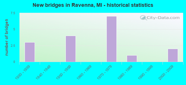
- New bridges - historical statistics
- 31930-1939
- 41950-1959
- 71970-1979
- 11980-1989
- 22000-2009

- Reconstructed bridges - Historical Statistics
- 11990-1999
- 12000-2009


- Bridge Condition - Deck
- 68.8%Good
- 18.8%Satisfactory
- 6.3%Fair
- 6.3%Critical

- Bridge Condition - Superstructure
- 12.5%Very good
- 25.0%Good
- 25.0%Satisfactory
- 12.5%Fair
- 18.8%Serious
- 6.3%Critical

- Bridge Condition - Substructure
- 6.3%Very good
- 31.3%Good
- 31.3%Satisfactory
- 31.3%Fair

- Bridge Condition - Channel
- 11.8%Very good
- 5.9%Good
- 47.1%Satisfactory
- 29.4%Fair
- 5.9%Poor
Find on map >> Show street view
Structure Number: 7559, Location: 4.6 MI W OF M-37 (Lat: 43.235303, Lng: -85.903694), Route carried "on" structure: State highway 46, Year Built: 1958, Year Reconstructed: 1999, Status: Open, Structure Length: 1.22m (4.00ft), Average Daily Traffic: 5,976 (year 2007), Truck Traffic: 12%, Average Future Daily Traffic: 8,358 (year 2018), Design Load: HS 20, Features Intersected: CROCKERY CREEK
Minimum Vertical Clearance: 30.48m (100.00ft), Kilometerpoint: 28.013, Lanes on structure: 2, Base Highway Network: Yes (Inventory Route: 85, Subroute: 3), Owner: State Highway Agency, Approaching Roadway Width: 13.4m (44.0ft), Skew: 2 degrees, Material/Design: Prestressed concrete, Design/Construction: Box Beam or Girders - Multiple, Number Of Spans In Main Unit: 1, Length of Maximum Span: 12.2m (40.0ft), Curb or Sidewalk Widths: Left: 0.4m (1.3ft), Right: 0.4m (1.3ft), Curb-To-Curb Width: 13.4m (44.0ft), Out-to-Out Width: 15.0m (49.2ft)
Condition: Deck: Good, Superstructure: Serious, Substructure: Good, Channel: Satisfactory, Operating Rating: 57.7 metric tons, Method Used To Determine Operating Rating: Load Factor (LF) rating reported by rating factor (RF) method using MS18 loading, Inventory Rating: 34.7 metric tons, Method Used To Determine Inventory Rating: Load Factor (LF) rating reported by rating factor (RF) method using MS18 loading, Structural Evaluation: High priority of corrective action, Deck Geometry: Equal to present minimum criteria, Waterway Adequacy: Equal to present desirable criteria, Approach Roadway Alignment: Better than present minimum criteria, Designated Inspection Frequency: Every 12 months, Inspection Date: June 2021, Deck Structure Type: Concrete Cast-file-Place, Wearing Surface/Protective System: Wearing Surface: Monolithic Concrete, Deck Protection: Epoxy Coated Reinforcing
Find on map >> Show street view
Structure Number: 7647, Location: 11.2 MI E OF I-96 (Lat: 43.162214, Lng: -85.963242), Route carried "on" structure: County highway 87, Year Built: 1953, Year Reconstructed: 2013, Status: Open, Structure Length: 3.66m (12.01ft), Average Daily Traffic: 1,987 (year 2012), Truck Traffic: 5%, Average Future Daily Traffic: 3,294 (year 2032), Design Load: HS 20, Features Intersected: CROCKERY CREEK, Facility Carried by Structure: ELLIS ROAD
Minimum Vertical Clearance: 30.48m (100.00ft), Kilometerpoint: 8.396, Lanes on structure: 2, Owner: County Highway Agency, Approaching Roadway Width: 12.2m (40.0ft), Material/Design: Steel continuous, Design/Construction: Stringer/Multi-beam, Number Of Spans In Main Unit: 3, Length of Maximum Span: 14.0m (45.9ft), Curb-To-Curb Width: 8.7m (28.5ft), Out-to-Out Width: 9.4m (30.8ft)
Condition: Deck: Good, Superstructure: Good, Substructure: Good, Channel: Satisfactory, Operating Rating: 45.4 metric tons, Method Used To Determine Operating Rating: Load and Resistance Factor Rating (LRFR) rating reported by rating factor(RF) method using HL-93 loadings, Inventory Rating: 35.6 metric tons, Method Used To Determine Inventory Rating: Load and Resistance Factor Rating (LRFR) rating reported by rating factor(RF) method using HL-93 loadings, Structural Evaluation: Better than present minimum criteria, Deck Geometry: Somewhat better than minimum adequacy, Waterway Adequacy: Equal to present desirable criteria, Approach Roadway Alignment: Equal to present desirable criteria, Designated Inspection Frequency: Every 24 months, Inspection Date: September 2020, Deck Structure Type: Concrete Cast-file-Place, Wearing Surface/Protective System: Wearing Surface: Monolithic Concrete, Deck Protection: Epoxy Coated Reinforcing
Find on map >> Show street view
Structure Number: 7661, Location: 0.7 MI S OF MT GARFIED RD (Lat: 43.136600, Lng: -85.987497), Route carried "on" structure: County highway , Year Built: 1950, Status: Open, Structure Length: 5.58m (18.31ft), Average Daily Traffic: 1,460 (year 2011), Truck Traffic: 7%, Average Future Daily Traffic: 1,890 (year 2024), Design Load: H 15, Features Intersected: CROCKERY CREEK, Facility Carried by Structure: MOORLAND ROAD
Minimum Vertical Clearance: 30.48m (100.00ft), Kilometerpoint: 2.034, Lanes on structure: 2, Owner: County Highway Agency, Approaching Roadway Width: 11.0m (36.1ft), Skew: 4 degrees, Material/Design: Steel, Design/Construction: Stringer/Multi-beam, Number Of Spans In Main Unit: 3, Length of Maximum Span: 18.3m (60.0ft), Curb-To-Curb Width: 7.3m (24.0ft), Out-to-Out Width: 9.0m (29.5ft)
Condition: Deck: Good, Superstructure: Satisfactory, Substructure: Fair, Channel: Fair, Operating Rating: 56.7 metric tons, Method Used To Determine Operating Rating: Load Factor (LF), Inventory Rating: 34.0 metric tons, Method Used To Determine Inventory Rating: Load Factor (LF), Structural Evaluation: Somewhat better than minimum adequacy, Deck Geometry: Meets minimum limits, Waterway Adequacy: Equal to present desirable criteria, Approach Roadway Alignment: Equal to present desirable criteria, Designated Inspection Frequency: Every 24 months, Inspection Date: September 2020, Deck Structure Type: Concrete Cast-file-Place, Wearing Surface/Protective System: Wearing Surface: Bituminous
Find on map >> Show street view
Structure Number: 7663, Location: 1.3 MI S OF ELLIS RD (Lat: 43.143542, Lng: -85.927633), Route carried "on" structure: County highway 6181, Year Built: 1935, Status: Open, Structure Length: 0.94m (3.08ft), Average Daily Traffic: 3,315 (year 2002), Truck Traffic: 7%, Average Future Daily Traffic: 4,940 (year 2022), Design Load: HS 20, Features Intersected: RIO GRANDE CREEK, Facility Carried by Structure: RAVENNA ROAD
Minimum Vertical Clearance: 30.48m (100.00ft), Kilometerpoint: 2.754, Lanes on structure: 2, Owner: County Highway Agency, Approaching Roadway Width: 12.2m (40.0ft), Material/Design: Steel, Design/Construction: Stringer/Multi-beam, Number Of Spans In Main Unit: 1, Length of Maximum Span: 8.8m (28.9ft), Curb-To-Curb Width: 9.4m (30.8ft), Out-to-Out Width: 10.5m (34.4ft)
Condition: Deck: Good, Superstructure: Satisfactory, Substructure: Fair, Channel: Fair, Operating Rating: 81.1 metric tons, Method Used To Determine Operating Rating: Load Factor (LF), Inventory Rating: 48.6 metric tons, Method Used To Determine Inventory Rating: Load Factor (LF), Structural Evaluation: Somewhat better than minimum adequacy, Deck Geometry: Meets minimum limits, Waterway Adequacy: Equal to present desirable criteria, Approach Roadway Alignment: Equal to present desirable criteria, Designated Inspection Frequency: Every 24 months, Inspection Date: September 2020, Deck Structure Type: Concrete Cast-file-Place, Wearing Surface/Protective System: Wearing Surface: Bituminous
Find on map >> Show street view
Structure Number: 7664, Location: 1.3 MI N OF APPLE AVE M46 (Lat: 43.253961, Lng: -85.947981), Route carried "on" structure: County highway , Year Built: 1975, Status: Open, Structure Length: 0.94m (3.08ft), Average Daily Traffic: 1,580 (year 2002), Truck Traffic: 7%, Average Future Daily Traffic: 2,350 (year 2022), Design Load: HS 20, Features Intersected: BIG & OUTLET DRAIN, Facility Carried by Structure: RAVENNA ROAD
Minimum Vertical Clearance: 30.48m (100.00ft), Kilometerpoint: 8.161, Lanes on structure: 2, Owner: County Highway Agency, Approaching Roadway Width: 13.4m (44.0ft), Skew: 3 degrees, Material/Design: Prestressed concrete, Design/Construction: Box Beam or Girders - Multiple, Number Of Spans In Main Unit: 1, Length of Maximum Span: 7.5m (24.6ft), Curb-To-Curb Width: 11.0m (36.1ft), Out-to-Out Width: 11.1m (36.4ft)
Condition: Deck: Good, Superstructure: Good, Substructure: Good, Channel: Good, Operating Rating: 48.9 metric tons, Method Used To Determine Operating Rating: Load Factor (LF), Inventory Rating: 30.0 metric tons, Method Used To Determine Inventory Rating: Load Factor (LF), Structural Evaluation: Better than present minimum criteria, Deck Geometry: Equal to present minimum criteria, Waterway Adequacy: Better than present minimum criteria, Approach Roadway Alignment: Equal to present desirable criteria, Designated Inspection Frequency: Every 24 months, Inspection Date: September 2020, Deck Structure Type: Concrete Precast Panels, Wearing Surface/Protective System: Wearing Surface: Bituminous
Find on map >> Show street view
Structure Number: 7679, Location: 0.4 MI W OF RAVENNA RD (Lat: 43.249936, Lng: -85.955208), Route carried "on" structure: County highway , Year Built: 1974, Status: Open, Structure Length: 0.73m (2.40ft), Average Daily Traffic: 235 (year 2004), Truck Traffic: 2%, Average Future Daily Traffic: 360 (year 2024), Design Load: HS 20, Features Intersected: BIG & OUTLET DRAIN, Facility Carried by Structure: HALL ROAD
Minimum Vertical Clearance: 30.48m (100.00ft), Kilometerpoint: 2.651, Lanes on structure: 2, Owner: County Highway Agency, Approaching Roadway Width: 9.8m (32.2ft), Skew: 3 degrees, Material/Design: Wood or Timber, Design/Construction: Slab, Number Of Spans In Main Unit: 1, Length of Maximum Span: 7.3m (24.0ft), Curb-To-Curb Width: 10.1m (33.1ft), Out-to-Out Width: 10.3m (33.8ft)
Condition: Deck: Satisfactory, Superstructure: Satisfactory, Substructure: Satisfactory, Channel: Satisfactory, Operating Rating: 44.4 metric tons, Method Used To Determine Operating Rating: Allowable Stress (AS), Inventory Rating: 31.4 metric tons, Method Used To Determine Inventory Rating: Allowable Stress (AS), Structural Evaluation: Equal to present minimum criteria, Deck Geometry: Better than present minimum criteria, Waterway Adequacy: Equal to present desirable criteria, Approach Roadway Alignment: Equal to present desirable criteria, Designated Inspection Frequency: Every 24 months, Inspection Date: September 2020, Deck Structure Type: Wood or Timber, Wearing Surface/Protective System: Wearing Surface: Bituminous
Find on map >> Show street view
Structure Number: 768, Location: 0.6 MI N OF M-46 (Lat: 43.241058, Lng: -85.968031), Route carried "on" structure: County highway , Year Built: 1973, Status: Open, Structure Length: 0.79m (2.59ft), Average Daily Traffic: 615 (year 2004), Average Future Daily Traffic: 950 (year 2024), Design Load: HS 20, Features Intersected: BIG & OUTLET DRAIN, Facility Carried by Structure: BOSSETT ROAD
Minimum Vertical Clearance: 30.48m (100.00ft), Kilometerpoint: 2.289, Lanes on structure: 2, Owner: County Highway Agency, Approaching Roadway Width: 9.8m (32.2ft), Skew: 4 degrees, Material/Design: Prestressed concrete, Design/Construction: Box Beam or Girders - Multiple, Number Of Spans In Main Unit: 1, Length of Maximum Span: 7.9m (25.9ft), Curb-To-Curb Width: 10.4m (34.1ft), Out-to-Out Width: 10.5m (34.4ft)
Condition: Deck: Good, Superstructure: Satisfactory, Substructure: Fair, Channel: Satisfactory, Operating Rating: 70.5 metric tons, Method Used To Determine Operating Rating: Load Factor (LF), Inventory Rating: 42.3 metric tons, Method Used To Determine Inventory Rating: Load Factor (LF), Structural Evaluation: Somewhat better than minimum adequacy, Deck Geometry: Equal to present minimum criteria, Waterway Adequacy: Equal to present minimum criteria, Approach Roadway Alignment: Equal to present desirable criteria, Designated Inspection Frequency: Every 24 months, Inspection Date: September 2020, Deck Structure Type: Concrete Precast Panels, Wearing Surface/Protective System: Wearing Surface: Bituminous
Find on map >> Show street view
Structure Number: 7688, Location: 0.1 MI W OF BLACKMERE RD (Lat: 43.146411, Lng: -85.948714), Route carried "on" structure: County highway , Year Built: 1932, Status: Posted for load, Structure Length: 1.09m (3.58ft), Average Daily Traffic: 50 (year 2004), Average Future Daily Traffic: 50 (year 2024), Design Load: H 15, Features Intersected: RIO GRANDE CREEK, Facility Carried by Structure: PATTERSON PARK RD
Minimum Vertical Clearance: 30.48m (100.00ft), Kilometerpoint: 0.214, Lanes on structure: 1, Owner: County Highway Agency, Approaching Roadway Width: 4.3m (14.1ft), Skew: 2 degrees, Material/Design: Steel, Design/Construction: Stringer/Multi-beam, Number Of Spans In Main Unit: 1, Length of Maximum Span: 10.6m (34.8ft), Curb-To-Curb Width: 4.3m (14.1ft), Out-to-Out Width: 5.6m (18.4ft)
Condition: Deck: Satisfactory, Superstructure: Serious, Substructure: Satisfactory, Channel: Satisfactory, Operating Rating: 6.8 metric tons, Method Used To Determine Operating Rating: Load Factor (LF), Inventory Rating: 4.1 metric tons, Method Used To Determine Inventory Rating: Load Factor (LF), Structural Evaluation: High priority of corrective action, Deck Geometry: Equal to present minimum criteria, Waterway Adequacy: Somewhat better than minimum adequacy, Approach Roadway Alignment: Somewhat better than minimum adequacy, Bridge Posting: Required (Relationship of Operating Rating to Maximum Legal Load: > 39.9% below), Designated Inspection Frequency: Every 12 months, Inspection Date: September 2021, Deck Structure Type: Concrete Cast-file-Place, Wearing Surface/Protective System: Wearing Surface: Monolithic Concrete
Find on map >> Show street view
Structure Number: 7689, Location: 0.2 MI W OF BLACKMERE RD (Lat: 43.146744, Lng: -85.950739), Route carried "on" structure: County highway , Year Built: 1932, Status: Posted for load, Structure Length: 1.09m (3.58ft), Average Daily Traffic: 50 (year 2004), Average Future Daily Traffic: 50 (year 2024), Design Load: H 15, Features Intersected: RIO GRANDE CREEK, Facility Carried by Structure: PATTERSON PARK RD
Minimum Vertical Clearance: 30.48m (100.00ft), Kilometerpoint: 0.000, Lanes on structure: 1, Owner: County Highway Agency, Approaching Roadway Width: 4.3m (14.1ft), Skew: 3 degrees, Material/Design: Steel, Design/Construction: Stringer/Multi-beam, Number Of Spans In Main Unit: 1, Length of Maximum Span: 10.3m (33.8ft), Curb-To-Curb Width: 4.3m (14.1ft), Out-to-Out Width: 5.6m (18.4ft)
Condition: Deck: Satisfactory, Superstructure: Serious, Substructure: Satisfactory, Channel: Satisfactory, Operating Rating: 6.8 metric tons, Method Used To Determine Operating Rating: Allowable Stress (AS) rating reported by rating factor (RF) method using MS18 loading, Inventory Rating: 4.2 metric tons, Method Used To Determine Inventory Rating: Allowable Stress (AS) rating reported by rating factor (RF) method using MS18 loading, Structural Evaluation: High priority of corrective action, Deck Geometry: Equal to present minimum criteria, Waterway Adequacy: Somewhat better than minimum adequacy, Approach Roadway Alignment: Somewhat better than minimum adequacy, Bridge Posting: Required (Relationship of Operating Rating to Maximum Legal Load: > 39.9% below), Designated Inspection Frequency: Every 12 months, Inspection Date: September 2021, Deck Structure Type: Concrete Cast-file-Place, Wearing Surface/Protective System: Wearing Surface: Monolithic Concrete
Find on map >> Show street view
Structure Number: 769, Location: 0.1 MI S OF MT GARFIELD (Lat: 43.146403, Lng: -85.947397), Route carried "on" structure: County highway , Year Built: 1971, Status: Posted for load, Structure Length: 0.79m (2.59ft), Average Daily Traffic: 850 (year 2015), Truck Traffic: 10%, Design Load: HS 20, Features Intersected: RIO GRANDE CREEK, Facility Carried by Structure: BLACKMER ROAD
Minimum Vertical Clearance: 30.48m (100.00ft), Kilometerpoint: 3.080, Lanes on structure: 2, Owner: County Highway Agency, Approaching Roadway Width: 9.8m (32.2ft), Material/Design: Wood or Timber, Design/Construction: Slab, Number Of Spans In Main Unit: 1, Length of Maximum Span: 7.9m (25.9ft), Curb-To-Curb Width: 9.8m (32.2ft), Out-to-Out Width: 10.3m (33.8ft)
Condition: Deck: Fair, Superstructure: Fair, Substructure: Fair, Channel: Poor, Operating Rating: 21.4 metric tons, Method Used To Determine Operating Rating: Allowable Stress (AS) rating reported by rating factor (RF) method using MS18 loading, Inventory Rating: 8.7 metric tons, Method Used To Determine Inventory Rating: Allowable Stress (AS) rating reported by rating factor (RF) method using MS18 loading, Structural Evaluation: High priority of replacement, Deck Geometry: Equal to present minimum criteria, Waterway Adequacy: Equal to present desirable criteria, Approach Roadway Alignment: Equal to present desirable criteria, Bridge Posting: Required (Relationship of Operating Rating to Maximum Legal Load: 20.0 - 29.9% below), Length Of Structure Improvement: 5.00m (16.40ft), Designated Inspection Frequency: Every 12 months, Inspection Date: September 2021, Bridge Improvement Cost: $568,930,000, Deck Structure Type: Wood or Timber, Wearing Surface/Protective System: Wearing Surface: Gravel
Find on map >> Show street view
Structure Number: 7691, Location: 0.45 MI N OF HILE RD (Lat: 43.176017, Lng: -85.947833), Route carried "on" structure: County highway , Year Built: 1981, Status: Open, Structure Length: 2.74m (8.99ft), Average Daily Traffic: 885 (year 2018), Truck Traffic: 2%, Average Future Daily Traffic: 1,079 (year 2038), Design Load: HS 20+Mod, Features Intersected: CROCKERY CREEK, Facility Carried by Structure: BLACKMER ROAD
Minimum Vertical Clearance: 30.48m (100.00ft), Kilometerpoint: 6.402, Lanes on structure: 2, Owner: County Highway Agency, Approaching Roadway Width: 9.8m (32.2ft), Material/Design: Prestressed concrete, Design/Construction: Box Beam or Girders - Multiple, Number Of Spans In Main Unit: 2, Length of Maximum Span: 13.7m (44.9ft), Curb-To-Curb Width: 10.4m (34.1ft), Out-to-Out Width: 10.4m (34.1ft)
Condition: Deck: Good, Superstructure: Fair, Substructure: Satisfactory, Channel: Satisfactory, Operating Rating: 44.7 metric tons, Method Used To Determine Operating Rating: Load and Resistance Factor Rating (LRFR) rating reported by rating factor(RF) method using HL-93 loadings, Inventory Rating: 34.3 metric tons, Method Used To Determine Inventory Rating: Load and Resistance Factor Rating (LRFR) rating reported by rating factor(RF) method using HL-93 loadings, Structural Evaluation: Somewhat better than minimum adequacy, Deck Geometry: Equal to present minimum criteria, Waterway Adequacy: Equal to present desirable criteria, Approach Roadway Alignment: Equal to present desirable criteria, Designated Inspection Frequency: Every 24 months, Inspection Date: September 2020, Deck Structure Type: Concrete Precast Panels, Wearing Surface/Protective System: Wearing Surface: Bituminous, Membrane: Preformed Fabric, Deck Protection: Epoxy Coated Reinforcing
Find on map >> Show street view
Structure Number: 7692, Location: 1.0 MI S OF ELLIS RD (Lat: 43.147981, Lng: -85.907789), Route carried "on" structure: County highway , Year Built: 1972, Status: Posted for load, Structure Length: 0.79m (2.59ft), Average Daily Traffic: 100 (year 2020), Truck Traffic: 5%, Average Future Daily Traffic: 180 (year 2040), Design Load: H 20, Features Intersected: RIO GRANDE CREEK, Facility Carried by Structure: SQUIRES ROAD
Minimum Vertical Clearance: 30.48m (100.00ft), Kilometerpoint: 3.228, Lanes on structure: 2, Owner: County Highway Agency, Approaching Roadway Width: 9.8m (32.2ft), Material/Design: Wood or Timber, Design/Construction: Slab, Number Of Spans In Main Unit: 1, Length of Maximum Span: 7.9m (25.9ft), Curb-To-Curb Width: 9.8m (32.2ft), Out-to-Out Width: 10.3m (33.8ft)
Condition: Deck: Good, Superstructure: Good, Substructure: Satisfactory, Channel: Satisfactory, Operating Rating: 40.5 metric tons, Method Used To Determine Operating Rating: Allowable Stress (AS) rating reported by rating factor (RF) method using MS18 loading, Inventory Rating: 26.9 metric tons, Method Used To Determine Inventory Rating: Allowable Stress (AS) rating reported by rating factor (RF) method using MS18 loading, Structural Evaluation: Equal to present minimum criteria, Deck Geometry: Equal to present desirable criteria, Waterway Adequacy: Equal to present desirable criteria, Approach Roadway Alignment: Equal to present minimum criteria, Bridge Posting: Required (Relationship of Operating Rating to Maximum Legal Load: > 39.9% below), Designated Inspection Frequency: Every 24 months, Inspection Date: August 2020, Deck Structure Type: Wood or Timber, Wearing Surface/Protective System: Wearing Surface: Gravel
Find on map >> Show street view
Structure Number: 7707, Location: IN RAVENNA (Lat: 43.188078, Lng: -85.936567), Route carried "on" structure: City street 6181, Year Built: 2009, Status: Open, Structure Length: 2.44m (8.01ft), Average Daily Traffic: 5,749 (year 2007), Truck Traffic: 5%, Average Future Daily Traffic: 8,500 (year 2027), Features Intersected: CROCKERY CREEK, Facility Carried by Structure: SOUTH MAIN STREET
Minimum Vertical Clearance: 30.48m (100.00ft), Kilometerpoint: 8.021, Lanes on structure: 2, Owner: City or Municipal Highway Agency, Approaching Roadway Width: 12.2m (40.0ft), Skew: 1 degrees, Material/Design: Prestressed concrete, Design/Construction: Box Beam or Girders - Single/Spread, Number Of Spans In Main Unit: 1, Length of Maximum Span: 24.0m (78.7ft), Curb or Sidewalk Widths: Left: 0.0m, Right: 2.1m (6.9ft), Curb-To-Curb Width: 12.2m (40.0ft), Out-to-Out Width: 15.4m (50.5ft)
Condition: Deck: Good, Superstructure: Very good, Substructure: Very good, Channel: Very good, Operating Rating: 82.3 metric tons, Method Used To Determine Operating Rating: Load Factor (LF), Inventory Rating: 49.4 metric tons, Method Used To Determine Inventory Rating: Load Factor (LF), Structural Evaluation: Equal to present desirable criteria, Deck Geometry: Somewhat better than minimum adequacy, Waterway Adequacy: Equal to present desirable criteria, Approach Roadway Alignment: Better than present minimum criteria, Designated Inspection Frequency: Every 24 months, Inspection Date: September 2021, Deck Structure Type: Concrete Cast-file-Place, Wearing Surface/Protective System: Wearing Surface: Monolithic Concrete, Deck Protection: Epoxy Coated Reinforcing
Find on map >> Show street view
Structure Number: 8856, Location: 0.19 MILES N OF TRUMAN (Lat: 43.194139, Lng: -85.879239), Route carried "on" structure: County highway 7085, Year Built: 2002, Status: Open, Structure Length: 2.01m (6.59ft), Average Daily Traffic: 955 (year 2020), Truck Traffic: 5%, Average Future Daily Traffic: 1,725 (year 2040), Design Load: HS 25 or greater, Features Intersected: N BRANCH CROCKERY CREEK, Facility Carried by Structure: 36TH AVE
Minimum Vertical Clearance: 30.48m (100.00ft), Kilometerpoint: 0.303, Lanes on structure: 2, Owner: County Highway Agency, Approaching Roadway Width: 12.2m (40.0ft), Material/Design: Prestressed concrete, Design/Construction: Stringer/Multi-beam, Number Of Spans In Main Unit: 1, Length of Maximum Span: 19.5m (64.0ft), Curb-To-Curb Width: 13.1m (43.0ft), Out-to-Out Width: 13.2m (43.3ft)
Condition: Deck: Good, Superstructure: Very good, Substructure: Good, Channel: Very good, Operating Rating: 78.7 metric tons, Method Used To Determine Operating Rating: Load and Resistance Factor Rating (LRFR) rating reported by rating factor(RF) method using HL-93 loadings, Inventory Rating: 55.7 metric tons, Method Used To Determine Inventory Rating: Load and Resistance Factor Rating (LRFR) rating reported by rating factor(RF) method using HL-93 loadings, Structural Evaluation: Better than present minimum criteria, Deck Geometry: Superior to present desirable criteria, Waterway Adequacy: Equal to present desirable criteria, Approach Roadway Alignment: Equal to present desirable criteria, Designated Inspection Frequency: Every 24 months, Inspection Date: December 2020, Deck Structure Type: Concrete Cast-file-Place, Wearing Surface/Protective System: Wearing Surface: Monolithic Concrete, Deck Protection: Epoxy Coated Reinforcing
Find on map >> Show street view
Structure Number: 8869, Location: SECTION 6 CHESTER TWP (Lat: 43.194839, Lng: -85.889267), Route carried "on" structure: County highway , Year Built: 1974, Status: Open, Structure Length: 1.73m (5.68ft), Average Daily Traffic: 473 (year 2019), Truck Traffic: 5%, Average Future Daily Traffic: 855 (year 2039), Design Load: H 20, Features Intersected: N BRANCH CROCKERY CREEK, Facility Carried by Structure: 40TH AVENUE
Minimum Vertical Clearance: 30.48m (100.00ft), Kilometerpoint: 15.759, Lanes on structure: 2, Owner: County Highway Agency, Approaching Roadway Width: 11.0m (36.1ft), Material/Design: Prestressed concrete, Design/Construction: Box Beam or Girders - Multiple, Number Of Spans In Main Unit: 1, Length of Maximum Span: 17.3m (56.8ft), Curb-To-Curb Width: 11.0m (36.1ft), Out-to-Out Width: 11.1m (36.4ft)
Condition: Deck: Good, Superstructure: Good, Substructure: Good, Channel: Fair, Operating Rating: 36.3 metric tons, Method Used To Determine Operating Rating: Load and Resistance Factor Rating (LRFR) rating reported by rating factor(RF) method using HL-93 loadings, Inventory Rating: 27.9 metric tons, Method Used To Determine Inventory Rating: Load and Resistance Factor Rating (LRFR) rating reported by rating factor(RF) method using HL-93 loadings, Structural Evaluation: Better than present minimum criteria, Deck Geometry: Better than present minimum criteria, Waterway Adequacy: Equal to present desirable criteria, Approach Roadway Alignment: Equal to present desirable criteria, Designated Inspection Frequency: Every 24 months, Inspection Date: December 2020, Deck Structure Type: Concrete Precast Panels, Wearing Surface/Protective System: Wearing Surface: Bituminous, Membrane: Preformed Fabric
Find on map >> Show street view
Structure Number: 887, Location: SECTION 5 CHESTER TWP (Lat: 43.191625, Lng: -85.869250), Route carried "on" structure: County highway , Year Built: 1973, Status: Posted for load, Structure Length: 1.67m (5.48ft), Average Daily Traffic: 735 (year 2019), Truck Traffic: 5%, Average Future Daily Traffic: 1,330 (year 2039), Design Load: H 20, Features Intersected: N BRANCH CROCKERY CREEK, Facility Carried by Structure: 32ND AVE
Minimum Vertical Clearance: 30.48m (100.00ft), Kilometerpoint: 8.095, Lanes on structure: 2, Owner: County Highway Agency, Approaching Roadway Width: 11.0m (36.1ft), Skew: 3 degrees, Material/Design: Prestressed concrete, Design/Construction: Box Beam or Girders - Multiple, Number Of Spans In Main Unit: 1, Length of Maximum Span: 16.7m (54.8ft), Curb-To-Curb Width: 11.0m (36.1ft), Out-to-Out Width: 11.1m (36.4ft)
Condition: Deck: Critical, Superstructure: Critical, Substructure: Fair, Channel: Fair, Operating Rating: 35.6 metric tons, Method Used To Determine Operating Rating: Load Factor (LF) rating reported by rating factor (RF) method using MS18 loading, Inventory Rating: 20.1 metric tons, Method Used To Determine Inventory Rating: Load Factor (LF) rating reported by rating factor (RF) method using MS18 loading, Structural Evaluation: High priority of replacement, Deck Geometry: Better than present minimum criteria, Waterway Adequacy: Equal to present desirable criteria, Approach Roadway Alignment: Equal to present desirable criteria, Bridge Posting: Required (Relationship of Operating Rating to Maximum Legal Load: 30.0 - 39.9% below), Designated Inspection Frequency: Every 12 months, Inspection Date: November 2021, Deck Structure Type: Concrete Precast Panels, Wearing Surface/Protective System: Wearing Surface: Bituminous, Membrane: Preformed Fabric
Find on map >> Show street view
Structure Number: 13348, Location: CASNOVIA TWP SEC 30 (Lat: 43.220936, Lng: -85.902289), Route carried "on" structure: County highway , Year Built: 1955, Status: Open, Structure Length: 1.09m (3.58ft), Average Daily Traffic: 148 (year 2006), Truck Traffic: 40%, Average Future Daily Traffic: 267 (year 2026), Design Load: HS 20, Features Intersected: CROCKERY CREEK, Facility Carried by Structure: LAKETON ROAD
Minimum Vertical Clearance: 30.48m (100.00ft), Kilometerpoint: 0.481, Lanes on structure: 2, Owner: County Highway Agency, Approaching Roadway Width: 7.9m (25.9ft), Material/Design: Steel, Design/Construction: Culvert, Number Of Spans In Main Unit: 2, Length of Maximum Span: 4.8m (15.7ft), Curb-To-Curb Width: 7.9m (25.9ft), Out-to-Out Width: 9.8m (32.2ft)
Condition: Channel: Fair, Culverts: Fair, Operating Rating: 97.2 metric tons, Method Used To Determine Operating Rating: Load and Resistance Factor Rating (LRFR) rating reported by rating factor(RF) method using HL-93 loadings, Inventory Rating: 79.7 metric tons, Method Used To Determine Inventory Rating: Load and Resistance Factor Rating (LRFR) rating reported by rating factor(RF) method using HL-93 loadings, Structural Evaluation: Somewhat better than minimum adequacy, Deck Geometry: Somewhat better than minimum adequacy, Waterway Adequacy: Somewhat better than minimum adequacy, Approach Roadway Alignment: Better than present minimum criteria, Designated Inspection Frequency: Every 24 months, Inspection Date: September 2020, Wearing Surface/Protective System: Wearing Surface: Gravel