Bridge Statistics for Raven, Virginia (VA)
Condition, Traffic, Stress, Structural Evaluation, Project Costs
- National Bridge Inventory (NBI) Statistics
- 14Number of bridges
- 56ft / 17.1mTotal length
- $1,495,000Total costs
- 16,584Total average daily traffic
- 729Total average daily truck traffic
- 19,860Total future (year 2040) average daily traffic
- National Bridge Inventory (NBI) Registered Bridges for Raven
- No street view available for this location
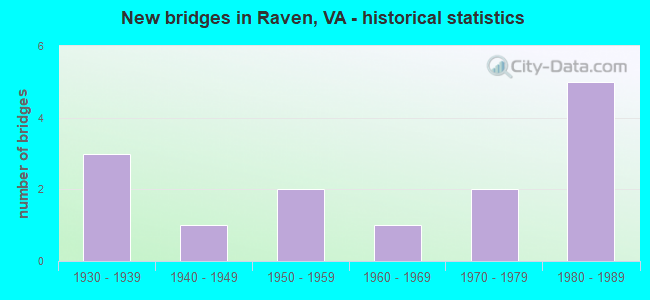
- New bridges - historical statistics
- 31930-1939
- 11940-1949
- 21950-1959
- 11960-1969
- 21970-1979
- 51980-1989
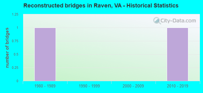
- Reconstructed bridges - Historical Statistics
- 11980-1989
- 01990-1999
- 02000-2009
- 12010-2019

- Bridge Condition - Deck
- 10.0%Good
- 40.0%Satisfactory
- 40.0%Fair
- 10.0%Poor
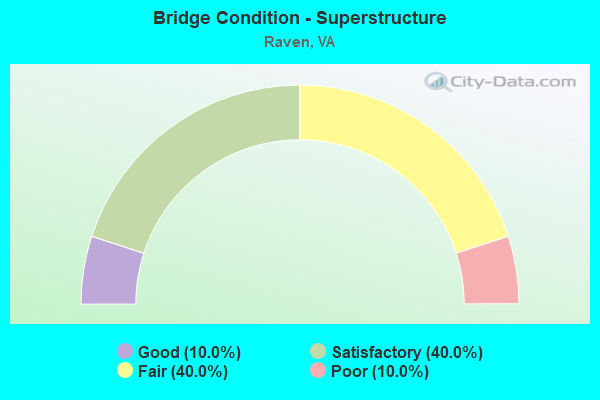
- Bridge Condition - Superstructure
- 10.0%Good
- 40.0%Satisfactory
- 40.0%Fair
- 10.0%Poor
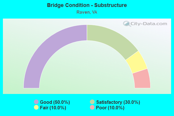
- Bridge Condition - Substructure
- 50.0%Good
- 30.0%Satisfactory
- 10.0%Fair
- 10.0%Poor
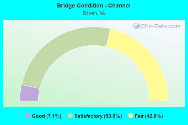
- Bridge Condition - Channel
- 7.1%Good
- 50.0%Satisfactory
- 42.9%Fair
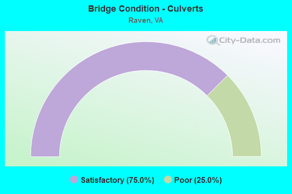
- Bridge Condition - Culverts
- 75.0%Satisfactory
- 25.0%Poor
Find on map >> Show street view
Structure Number: 3867, Location: 2.4 TO R634 &0.0 R460 (Lat: 37.173472, Lng: -81.941256), Route carried "on" structure: County highway 618, Year Built: 1967, Status: Open, Structure Length: 0.64m (2.10ft), Average Daily Traffic: 470 (year 2015), Average Future Daily Traffic: 529 (year 2040), Design Load: HS 20, Features Intersected: LEVISA RIVER, Facility Carried by Structure: Old Kent. Turnpike
Minimum Vertical Clearance: 30+ m (98+ ft), Kilometerpoint: 7.417, Lanes on structure: 2, Owner: State Highway Agency, Approaching Roadway Width: 6.7m (22.0ft), Material/Design: Concrete, Design/Construction: Culvert, Number Of Spans In Main Unit: 2, Length of Maximum Span: 3.0m (9.8ft)
Condition: Channel: Fair, Culverts: Satisfactory, Operating Rating: 44.5 metric tons, Method Used To Determine Operating Rating: Field evaluation and documented engineering judgment, Inventory Rating: 32.7 metric tons, Method Used To Determine Inventory Rating: Field evaluation and documented engineering judgment, Structural Evaluation: Equal to present minimum criteria, Waterway Adequacy: Better than present minimum criteria, Approach Roadway Alignment: Better than present minimum criteria, Length Of Structure Improvement: 0.64m (2.10ft), Designated Inspection Frequency: Every 24 months, Inspection Date: December 2021, Bridge Improvement Cost: $45,000, Roadway Improvement Cost: $10,000, Total Project Cost: $92,000 ( Estimate for 2015)
Find on map >> Show street view
Structure Number: 16337, Location: 6.9MTO80&4.03MTOTAZ.CO (Lat: 37.070419, Lng: -81.921947), Route carried "on" structure: State highway 67, Year Built: 1932, Status: Open, Structure Length: 0.88m (2.89ft), Average Daily Traffic: 2,344 (year 2020), Truck Traffic: 8%, Average Future Daily Traffic: 2,578 (year 2040), Design Load: H 20, Features Intersected: SWORDS CREEK, Facility Carried by Structure: SWORDS CREEK ROAD
Minimum Vertical Clearance: 30+ m (98+ ft), Kilometerpoint: 10.298, Lanes on structure: 2, Base Highway Network: Yes, Owner: State Highway Agency, Approaching Roadway Width: 7.3m (24.0ft), Skew: 4 degrees, Material/Design: Concrete, Design/Construction: Culvert, Number Of Spans In Main Unit: 2, Length of Maximum Span: 4.3m (14.1ft)
Condition: Channel: Good, Culverts: Satisfactory, Operating Rating: 44.5 metric tons, Method Used To Determine Operating Rating: Field evaluation and documented engineering judgment, Inventory Rating: 32.7 metric tons, Method Used To Determine Inventory Rating: Field evaluation and documented engineering judgment, Structural Evaluation: Equal to present minimum criteria, Waterway Adequacy: Better than present minimum criteria, Approach Roadway Alignment: Better than present minimum criteria, Designated Inspection Frequency: Every 24 months, Inspection Date: September 2021
Find on map >> Show street view
Structure Number: 1634, Location: 10.43MTO 80& .01MTO TAZCO (Lat: 37.085325, Lng: -81.863972), Route carried "on" structure: State highway 67, Year Built: 1953, Status: Posted for load, Structure Length: 0.67m (2.20ft), Average Daily Traffic: 2,244 (year 2020), Truck Traffic: 8%, Average Future Daily Traffic: 2,468 (year 2040), Design Load: H 20, Features Intersected: MILL CREEK, Facility Carried by Structure: SWORDS CREEK RD.
Minimum Vertical Clearance: 30+ m (98+ ft), Kilometerpoint: 16.782, Lanes on structure: 2, Owner: State Highway Agency, Approaching Roadway Width: 6.7m (22.0ft), Material/Design: Concrete, Design/Construction: Slab, Number Of Spans In Main Unit: 1, Length of Maximum Span: 6.1m (20.0ft), Curb-To-Curb Width: 7.1m (23.3ft), Out-to-Out Width: 8.7m (28.5ft)
Condition: Deck: Satisfactory, Superstructure: Satisfactory, Substructure: Good, Channel: Fair, Operating Rating: 36.3 metric tons, Method Used To Determine Operating Rating: Load and Resistance Factor (LRFR), Inventory Rating: 28.1 metric tons, Method Used To Determine Inventory Rating: Load and Resistance Factor (LRFR), Structural Evaluation: Equal to present minimum criteria, Deck Geometry: High priority of replacement, Waterway Adequacy: Better than present minimum criteria, Approach Roadway Alignment: Better than present minimum criteria, Length Of Structure Improvement: 0.67m (2.20ft), Designated Inspection Frequency: Every 24 months, Inspection Date: March 2021, Bridge Improvement Cost: $63,000, Roadway Improvement Cost: $10,000, Total Project Cost: $95,000 ( Estimate for 2020), Deck Structure Type: Concrete Cast-file-Place, Wearing Surface/Protective System: Wearing Surface: Bituminous
Find on map >> Show street view
Structure Number: 16407, Location: .00M TO 632 & .10M TO 67 (Lat: 37.070936, Lng: -81.925294), Route carried "on" structure: County highway 617, Year Built: 1989, Status: Open, Structure Length: 0.82m (2.69ft), Average Daily Traffic: 427 (year 2020), Truck Traffic: 5%, Average Future Daily Traffic: 470 (year 2040), Design Load: HS 20+Mod, Features Intersected: SULPHUR SPRING CREEK, Facility Carried by Structure: LYNN SPRINGS ROAD
Minimum Vertical Clearance: 30+ m (98+ ft), Kilometerpoint: 0.161, Lanes on structure: 2, Owner: State Highway Agency, Approaching Roadway Width: 6.1m (20.0ft), Skew: 3 degrees, Material/Design: Concrete, Design/Construction: Slab, Number Of Spans In Main Unit: 1, Length of Maximum Span: 7.6m (24.9ft), Curb or Sidewalk Widths: Left: 0.2m (0.7ft), Right: 0.2m (0.7ft), Curb-To-Curb Width: 7.6m (24.9ft), Out-to-Out Width: 8.5m (27.9ft)
Condition: Deck: Satisfactory, Superstructure: Satisfactory, Substructure: Good, Channel: Fair, Operating Rating: 89.8 metric tons, Method Used To Determine Operating Rating: Load and Resistance Factor (LRFR), Inventory Rating: 88.9 metric tons, Method Used To Determine Inventory Rating: Load and Resistance Factor (LRFR), Structural Evaluation: Equal to present minimum criteria, Deck Geometry: Meets minimum limits, Waterway Adequacy: Equal to present minimum criteria, Approach Roadway Alignment: Equal to present desirable criteria, Designated Inspection Frequency: Every 24 months, Inspection Date: Febuary 2021, Deck Structure Type: Concrete Cast-file-Place
Find on map >> Show street view
Structure Number: 16417, Location: .01M TO 67 & .29M TO 623 (Lat: 37.058286, Lng: -81.928883), Route carried "on" structure: County highway 622, Year Built: 1981, Status: Open, Structure Length: 0.98m (3.22ft), Average Daily Traffic: 667 (year 2015), Average Future Daily Traffic: 1,000 (year 2040), Design Load: HS 20+Mod, Features Intersected: SWORDS CREEK, Facility Carried by Structure: MILLER CREEK ROAD
Minimum Vertical Clearance: 30+ m (98+ ft), Kilometerpoint: 13.435, Lanes on structure: 2, Owner: State Highway Agency, Approaching Roadway Width: 6.4m (21.0ft), Material/Design: Concrete, Design/Construction: Slab, Number Of Spans In Main Unit: 1, Length of Maximum Span: 9.1m (29.9ft), Curb-To-Curb Width: 7.1m (23.3ft), Out-to-Out Width: 7.9m (25.9ft)
Condition: Deck: Fair, Superstructure: Fair, Substructure: Good, Channel: Satisfactory, Operating Rating: 89.8 metric tons, Method Used To Determine Operating Rating: Load and Resistance Factor (LRFR), Inventory Rating: 88.9 metric tons, Method Used To Determine Inventory Rating: Load and Resistance Factor (LRFR), Structural Evaluation: Somewhat better than minimum adequacy, Deck Geometry: Meets minimum limits, Waterway Adequacy: Better than present minimum criteria, Approach Roadway Alignment: Better than present minimum criteria, Designated Inspection Frequency: Every 24 months, Inspection Date: November 2021, Deck Structure Type: Concrete Cast-file-Place
Find on map >> Show street view
Structure Number: 16438, Location: .02M TO 67 & 1.44M TO 768 (Lat: 37.077367, Lng: -81.907903), Route carried "on" structure: County highway 634, Year Built: 1932, Status: Open, Structure Length: 0.76m (2.49ft), Average Daily Traffic: 911 (year 2015), Average Future Daily Traffic: 1,025 (year 2040), Features Intersected: PINE CREEK, Facility Carried by Structure: PINE CREEK ROAD
Minimum Vertical Clearance: 30+ m (98+ ft), Kilometerpoint: 0.090, Lanes on structure: 2, Owner: State Highway Agency, Approaching Roadway Width: 4.9m (16.1ft), Skew: 4 degrees, Material/Design: Steel, Design/Construction: Culvert, Number Of Spans In Main Unit: 3, Length of Maximum Span: 2.4m (7.9ft)
Condition: Channel: Fair, Culverts: Poor, Operating Rating: 33.6 metric tons, Method Used To Determine Operating Rating: Field evaluation and documented engineering judgment, Inventory Rating: 24.5 metric tons, Method Used To Determine Inventory Rating: Field evaluation and documented engineering judgment, Structural Evaluation: Meets minimum limits, Waterway Adequacy: Equal to present minimum criteria, Approach Roadway Alignment: Equal to present minimum criteria, Length Of Structure Improvement: 0.76m (2.49ft), Designated Inspection Frequency: Every 12 months, Inspection Date: September 2021, Bridge Improvement Cost: $10,000, Roadway Improvement Cost: $25,000, Total Project Cost: $46,000 ( Estimate for 2019)
Find on map >> Show street view
Structure Number: 16522, Location: .02MTOTAZCOLN&.15MTOENDRT (Lat: 37.084047, Lng: -81.863575), Route carried "on" structure: County highway 726, Year Built: 1978, Year Reconstructed: 2015, Status: Open, Structure Length: 1.04m (3.41ft), Average Daily Traffic: 349 (year 2015), Average Future Daily Traffic: 524 (year 2040), Design Load: HS 20+Mod, Features Intersected: MILL CREEK, Facility Carried by Structure: BRIDGE STREET
Minimum Vertical Clearance: 30+ m (98+ ft), Kilometerpoint: 0.280, Lanes on structure: 2, Owner: State Highway Agency, Approaching Roadway Width: 5.5m (18.0ft), Material/Design: Concrete, Design/Construction: Slab, Number Of Spans In Main Unit: 1, Length of Maximum Span: 9.8m (32.2ft), Curb-To-Curb Width: 8.1m (26.6ft), Out-to-Out Width: 8.2m (26.9ft)
Condition: Deck: Good, Superstructure: Good, Substructure: Good, Channel: Satisfactory, Operating Rating: 71.7 metric tons, Method Used To Determine Operating Rating: Load and Resistance Factor (LRFR), Inventory Rating: 55.3 metric tons, Method Used To Determine Inventory Rating: Load and Resistance Factor (LRFR), Structural Evaluation: Better than present minimum criteria, Deck Geometry: Somewhat better than minimum adequacy, Waterway Adequacy: Better than present minimum criteria, Approach Roadway Alignment: Better than present minimum criteria, Designated Inspection Frequency: Every 24 months, Inspection Date: May 2021, Deck Structure Type: Concrete Precast Panels, Wearing Surface/Protective System: Wearing Surface: Bituminous
Find on map >> Show street view
Structure Number: 18478, Location: .6TORCL;1.03TO460 (Lat: 37.086625, Lng: -81.854422), Route carried "on" structure: State highway 67, Year Built: 1949, Year Reconstructed: 1994, Status: Open, Structure Length: 1.52m (4.99ft), Average Daily Traffic: 3,848 (year 2020), Truck Traffic: 8%, Average Future Daily Traffic: 5,277 (year 2040), Design Load: HS 15, Features Intersected: COAL CREEK, Facility Carried by Structure: RAVEN RD.
Minimum Vertical Clearance: 30+ m (98+ ft), Kilometerpoint: 17.715, Lanes on structure: 3, Owner: State Highway Agency, Approaching Roadway Width: 9.8m (32.2ft), Material/Design: Concrete, Design/Construction: Stringer/Multi-beam, Number Of Spans In Main Unit: 1, Length of Maximum Span: 14.0m (45.9ft), Curb-To-Curb Width: 12.5m (41.0ft), Out-to-Out Width: 13.1m (43.0ft)
Condition: Deck: Satisfactory, Superstructure: Satisfactory, Substructure: Satisfactory, Channel: Satisfactory, Operating Rating: 43.5 metric tons, Method Used To Determine Operating Rating: Load and Resistance Factor (LRFR), Inventory Rating: 33.6 metric tons, Method Used To Determine Inventory Rating: Load and Resistance Factor (LRFR), Structural Evaluation: Equal to present minimum criteria, Deck Geometry: Meets minimum limits, Waterway Adequacy: Better than present minimum criteria, Approach Roadway Alignment: Better than present minimum criteria, Length Of Structure Improvement: 1.52m (4.99ft), Designated Inspection Frequency: Every 24 months, Inspection Date: March 2020, Bridge Improvement Cost: $173,000, Roadway Improvement Cost: $50,000, Total Project Cost: $377,000 ( Estimate for 2016), Deck Structure Type: Concrete Cast-file-Place
Find on map >> Show street view
Structure Number: 18641, Location: .05 FR 804 - 1.35 TO 618 (Lat: 37.114850, Lng: -81.869478), Route carried "on" structure: County highway 669, Year Built: 1982, Status: Open, Structure Length: 0.98m (3.22ft), Average Daily Traffic: 274 (year 2015), Average Future Daily Traffic: 392 (year 2040), Design Load: HS 20+Mod, Features Intersected: COAL CREEK
Minimum Vertical Clearance: 30+ m (98+ ft), Kilometerpoint: 2.162, Lanes on structure: 2, Owner: State Highway Agency, Approaching Roadway Width: 5.2m (17.1ft), Material/Design: Concrete, Design/Construction: Slab, Number Of Spans In Main Unit: 1, Length of Maximum Span: 9.1m (29.9ft), Curb-To-Curb Width: 6.7m (22.0ft), Out-to-Out Width: 7.3m (24.0ft)
Condition: Deck: Fair, Superstructure: Fair, Substructure: Satisfactory, Channel: Satisfactory, Operating Rating: 89.8 metric tons, Method Used To Determine Operating Rating: Load and Resistance Factor (LRFR), Inventory Rating: 87.1 metric tons, Method Used To Determine Inventory Rating: Load and Resistance Factor (LRFR), Structural Evaluation: Somewhat better than minimum adequacy, Deck Geometry: Meets minimum limits, Waterway Adequacy: Better than present minimum criteria, Approach Roadway Alignment: Better than present minimum criteria, Designated Inspection Frequency: Every 24 months, Inspection Date: June 2020, Deck Structure Type: Concrete Cast-file-Place
Find on map >> Show street view
Structure Number: 18642, Location: 2.20M 67;.15M RUSSELLCo (Lat: 37.107700, Lng: -81.886150), Route carried "on" structure: County highway 670, Year Built: 1973, Status: Open, Structure Length: 0.67m (2.20ft), Average Daily Traffic: 170 (year 2015), Average Future Daily Traffic: 191 (year 2040), Design Load: HS 20, Features Intersected: MILL CREEK
Minimum Vertical Clearance: 30+ m (98+ ft), Kilometerpoint: 0.766, Lanes on structure: 2, Owner: State Highway Agency, Approaching Roadway Width: 7.0m (23.0ft), Skew: 3 degrees, Material/Design: Concrete, Design/Construction: Culvert, Number Of Spans In Main Unit: 2, Length of Maximum Span: 3.0m (9.8ft)
Condition: Channel: Fair, Culverts: Satisfactory, Operating Rating: 44.5 metric tons, Method Used To Determine Operating Rating: Field evaluation and documented engineering judgment, Inventory Rating: 32.7 metric tons, Method Used To Determine Inventory Rating: Field evaluation and documented engineering judgment, Structural Evaluation: Equal to present minimum criteria, Waterway Adequacy: Better than present minimum criteria, Approach Roadway Alignment: Better than present minimum criteria, Designated Inspection Frequency: Every 24 months, Inspection Date: July 2021
Find on map >> Show street view
Structure Number: 18661, Location: .0M TO 67 & .02M TO 724 (Lat: 37.090186, Lng: -81.844508), Route carried "on" structure: County highway 723, Year Built: 1980, Status: Open, Structure Length: 3.96m (12.99ft), Average Daily Traffic: 2,545 (year 2020), Average Future Daily Traffic: 2,800 (year 2040), Design Load: HS 20+Mod, Features Intersected: CLINCH RIVER, Facility Carried by Structure: Bottom Road
Minimum Vertical Clearance: 30+ m (98+ ft), Kilometerpoint: 0.846, Lanes on structure: 2, Owner: State Highway Agency, Approaching Roadway Width: 6.7m (22.0ft), Skew: 1 degrees, Material/Design: Concrete, Design/Construction: Slab, Number Of Spans In Main Unit: 3, Length of Maximum Span: 15.2m (49.9ft), Curb or Sidewalk Widths: Left: 0.2m (0.7ft), Right: 1.2m (3.9ft), Curb-To-Curb Width: 9.1m (29.9ft), Out-to-Out Width: 11.3m (37.1ft)
Condition: Deck: Fair, Superstructure: Fair, Substructure: Satisfactory, Channel: Satisfactory, Operating Rating: 41.7 metric tons, Method Used To Determine Operating Rating: Load and Resistance Factor (LRFR), Inventory Rating: 31.8 metric tons, Method Used To Determine Inventory Rating: Load and Resistance Factor (LRFR), Structural Evaluation: Somewhat better than minimum adequacy, Deck Geometry: Meets minimum limits, Waterway Adequacy: Better than present minimum criteria, Approach Roadway Alignment: Better than present minimum criteria, Designated Inspection Frequency: Every 24 months, Inspection Date: March 2020, Deck Structure Type: Concrete Cast-file-Place
Find on map >> Show street view
Structure Number: 18682, Location: .25 FR 670-.48 ToRUS C.L. (Lat: 37.082728, Lng: -81.857511), Route carried "on" structure: County highway 772, Year Built: 1981, Status: Open, Structure Length: 1.10m (3.61ft), Average Daily Traffic: 508 (year 2015), Average Future Daily Traffic: 572 (year 2040), Design Load: HS 20, Features Intersected: MILL CREEK
Minimum Vertical Clearance: 30+ m (98+ ft), Kilometerpoint: 0.772, Lanes on structure: 2, Owner: State Highway Agency, Approaching Roadway Width: 5.2m (17.1ft), Skew: 4 degrees, Material/Design: Concrete, Design/Construction: Slab, Number Of Spans In Main Unit: 1, Length of Maximum Span: 10.4m (34.1ft), Curb-To-Curb Width: 7.3m (24.0ft), Out-to-Out Width: 7.9m (25.9ft)
Condition: Deck: Satisfactory, Superstructure: Satisfactory, Substructure: Good, Channel: Satisfactory, Operating Rating: 89.8 metric tons, Method Used To Determine Operating Rating: Load and Resistance Factor (LRFR), Inventory Rating: 88.0 metric tons, Method Used To Determine Inventory Rating: Load and Resistance Factor (LRFR), Structural Evaluation: Equal to present minimum criteria, Deck Geometry: Meets minimum limits, Waterway Adequacy: Better than present minimum criteria, Approach Roadway Alignment: Better than present minimum criteria, Designated Inspection Frequency: Every 24 months, Inspection Date: June 2020, Deck Structure Type: Concrete Cast-file-Place
Find on map >> Show street view
Structure Number: 18686, Location: .14 m to 460& .22 m fr 67 (Lat: 37.089839, Lng: -81.856300), Route carried "on" structure: County highway 806, Year Built: 1952, Status: Posted for load, Structure Length: 2.01m (6.59ft), Average Daily Traffic: 1,767 (year 2020), Truck Traffic: 2%, Average Future Daily Traffic: 1,944 (year 2040), Design Load: H 20, Features Intersected: COAL CREEK
Minimum Vertical Clearance: 30+ m (98+ ft), Kilometerpoint: 0.370, Lanes on structure: 2, Owner: State Highway Agency, Approaching Roadway Width: 20.1m (65.9ft), Skew: 3 degrees, Material/Design: Concrete, Design/Construction: Slab, Number Of Spans In Main Unit: 3, Length of Maximum Span: 6.7m (22.0ft), Curb or Sidewalk Widths: Left: 1.5m (4.9ft), Right: 1.5m (4.9ft), Curb-To-Curb Width: 12.2m (40.0ft), Out-to-Out Width: 15.8m (51.8ft)
Condition: Deck: Poor, Superstructure: Poor, Substructure: Poor, Channel: Fair, Operating Rating: 31.8 metric tons, Method Used To Determine Operating Rating: Load Factor (LF), Inventory Rating: 19.1 metric tons, Method Used To Determine Inventory Rating: Load Factor (LF), Structural Evaluation: Meets minimum limits, Deck Geometry: Better than present minimum criteria, Waterway Adequacy: Meets minimum limits, Approach Roadway Alignment: Better than present minimum criteria, Length Of Structure Improvement: 2.01m (6.59ft), Designated Inspection Frequency: Every 12 months, Inspection Date: June 2021, Bridge Improvement Cost: $226,000, Roadway Improvement Cost: $10,000, Total Project Cost: $398,000 ( Estimate for 2019), Deck Structure Type: Concrete Cast-file-Place, Wearing Surface/Protective System: Wearing Surface: Bituminous
Find on map >> Show street view
Structure Number: 29696, Location: 0.1-460EBL;0.0GreenbackRd (Lat: 37.173919, Lng: -81.939303), Route carried "on" structure: Business County highway 5417, Year Built: 1932, Status: Posted for load, Structure Length: 1.04m (3.41ft), Average Daily Traffic: 60 (year 2011), Average Future Daily Traffic: 90 (year 2040), Features Intersected: Granny Creek, Facility Carried by Structure: Bob Casey Rd.
Minimum Vertical Clearance: 30+ m (98+ ft), Kilometerpoint: 0.000, Lanes on structure: 1, Owner: County Highway Agency, Approaching Roadway Width: 3.2m (10.5ft), Skew: 3 degrees, Material/Design: Steel, Design/Construction: Girder and Floorbeam System, Number Of Spans In Main Unit: 1, Length of Maximum Span: 10.1m (33.1ft), Curb-To-Curb Width: 3.0m (9.8ft), Out-to-Out Width: 3.6m (11.8ft)
Condition: Deck: Fair, Superstructure: Fair, Substructure: Fair, Channel: Satisfactory, Operating Rating: 8.2 metric tons, Method Used To Determine Operating Rating: Load Factor (LF), Inventory Rating: 4.5 metric tons, Method Used To Determine Inventory Rating: Load Factor (LF), Structural Evaluation: High priority of replacement, Deck Geometry: High priority of replacement, Waterway Adequacy: Equal to present minimum criteria, Approach Roadway Alignment: Equal to present desirable criteria, Bridge Posting: Required (Relationship of Operating Rating to Maximum Legal Load: > 39.9% below), Length Of Structure Improvement: 1.77m (5.81ft), Designated Inspection Frequency: Every 12 months, Critical Feature Inspection Frequency: Every 12 months, Other Special Inspection Frequency: Every 12 months, Inspection Date: April 2021, Critical Feature Inspection Date: April 2021, Other Special Inspection Date: April 2021, Bridge Improvement Cost: $325,000, Roadway Improvement Cost: $33,000, Total Project Cost: $487,000 ( Estimate for 2018), Deck Structure Type: Concrete Cast-file-Place