Bridge Statistics for Randlett, Oklahoma (OK)
Condition, Traffic, Stress, Structural Evaluation, Project Costs
- National Bridge Inventory (NBI) Statistics
- 25Number of bridges
- 269ft / 81.7mTotal length
- $20,430,000Total costs
- 74,920Total average daily traffic
- 23,647Total average daily truck traffic
- National Bridge Inventory (NBI) Registered Bridges for Randlett
- No street view available for this location
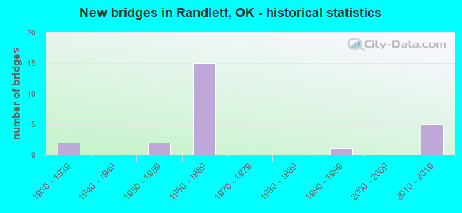
- New bridges - historical statistics
- 21930-1939
- 21950-1959
- 151960-1969
- 11990-1999
- 52010-2019


- Bridge Condition - Deck
- 20.0%Excellent
- 30.0%Very good
- 40.0%Good
- 10.0%Satisfactory

- Bridge Condition - Superstructure
- 30.0%Excellent
- 40.0%Very good
- 30.0%Good

- Bridge Condition - Substructure
- 30.0%Very good
- 60.0%Good
- 10.0%Satisfactory

- Bridge Condition - Channel
- 29.4%Very good
- 23.5%Good
- 29.4%Satisfactory
- 17.6%Fair

- Bridge Condition - Culverts
- 18.2%Very good
- 27.3%Good
- 45.5%Satisfactory
- 9.1%Fair
Find on map >> Show street view
Structure Number: 7018, Location: 4. E 2.3 S OF US 70-SH-36 (Lat: 34.134864, Lng: -98.452986), Route carried "on" structure: County highway N2540, Year Built: 1939, Status: Open, Structure Length: 0.98m (3.22ft), Average Daily Traffic: 100 (year 2020), Truck Traffic: 10%, Average Future Daily Traffic: 160 (year 2040), Design Load: HS 20, Features Intersected: RABBIT CREEK
Minimum Vertical Clearance: 30+ m (98+ ft), Kilometerpoint: 0.483, Lanes on structure: 2, Owner: County Highway Agency, Approaching Roadway Width: 7.9m (25.9ft), Material/Design: Concrete, Design/Construction: Culvert, Number Of Spans In Main Unit: 3, Length of Maximum Span: 3.0m (9.8ft), Curb-To-Curb Width: 8.0m (26.2ft), Out-to-Out Width: 8.7m (28.5ft)
Condition: Channel: Satisfactory, Culverts: Fair, Operating Rating: 37.6 metric tons, Method Used To Determine Operating Rating: Load Factor (LF), Inventory Rating: 22.5 metric tons, Method Used To Determine Inventory Rating: Load Factor (LF), Structural Evaluation: Somewhat better than minimum adequacy, Deck Geometry: Equal to present minimum criteria, Waterway Adequacy: Better than present minimum criteria, Approach Roadway Alignment: Equal to present desirable criteria, Length Of Structure Improvement: 3.41m (11.19ft), Designated Inspection Frequency: Every 24 months, Inspection Date: June 2021, Bridge Improvement Cost: $100,000, Roadway Improvement Cost: $75,000, Total Project Cost: $225,000 ( Estimate for 2015)
Find on map >> Show street view
Structure Number: 7158, Location: 3. E 1.7 S OF US 70-SH36 (Lat: 34.148556, Lng: -98.470536), Route carried "on" structure: County highway N2530, Year Built: 1939, Status: Open, Structure Length: 1.31m (4.30ft), Average Daily Traffic: 100 (year 2020), Truck Traffic: 10%, Average Future Daily Traffic: 160 (year 2040), Design Load: HS 20, Features Intersected: RABBIT CREEK
Minimum Vertical Clearance: 30+ m (98+ ft), Kilometerpoint: 1.127, Lanes on structure: 2, Owner: County Highway Agency, Approaching Roadway Width: 8.5m (27.9ft), Material/Design: Concrete, Design/Construction: Culvert, Number Of Spans In Main Unit: 4, Length of Maximum Span: 3.0m (9.8ft), Curb-To-Curb Width: 9.0m (29.5ft), Out-to-Out Width: 9.4m (30.8ft)
Condition: Channel: Fair, Culverts: Satisfactory, Inventory Rating: 21.8 metric tons, Method Used To Determine Inventory Rating: Load Factor (LF), Structural Evaluation: Equal to present minimum criteria, Deck Geometry: Better than present minimum criteria, Waterway Adequacy: Equal to present minimum criteria, Approach Roadway Alignment: Equal to present desirable criteria, Length Of Structure Improvement: 3.98m (13.06ft), Designated Inspection Frequency: Every 24 months, Inspection Date: June 2021, Bridge Improvement Cost: $100,000, Roadway Improvement Cost: $75,000, Total Project Cost: $225,000 ( Estimate for 2015)
Find on map >> Show street view
Structure Number: 11427, Location: .9 S 2.8 E OF US 70-SH36 (Lat: 34.159736, Lng: -98.474317), Route carried "on" structure: County highway E1969, Year Built: 1950, Status: Open, Structure Length: 0.64m (2.10ft), Average Daily Traffic: 100 (year 2020), Truck Traffic: 10%, Average Future Daily Traffic: 160 (year 2040), Design Load: HS 20, Features Intersected: RABBIT CREEK
Minimum Vertical Clearance: 30+ m (98+ ft), Kilometerpoint: 1.287, Lanes on structure: 2, Owner: County Highway Agency, Approaching Roadway Width: 8.5m (27.9ft), Material/Design: Concrete, Design/Construction: Culvert, Number Of Spans In Main Unit: 2, Length of Maximum Span: 3.0m (9.8ft), Curb-To-Curb Width: 12.2m (40.0ft), Out-to-Out Width: 12.8m (42.0ft)
Condition: Channel: Fair, Culverts: Satisfactory, Operating Rating: 37.2 metric tons, Method Used To Determine Operating Rating: Load Factor (LF), Inventory Rating: 21.8 metric tons, Method Used To Determine Inventory Rating: Load Factor (LF), Structural Evaluation: Equal to present minimum criteria, Deck Geometry: Superior to present desirable criteria, Waterway Adequacy: Equal to present minimum criteria, Approach Roadway Alignment: Equal to present desirable criteria, Length Of Structure Improvement: 2.72m (8.92ft), Designated Inspection Frequency: Every 24 months, Inspection Date: June 2021, Bridge Improvement Cost: $100,000, Roadway Improvement Cost: $75,000, Total Project Cost: $225,000 ( Estimate for 2015)
Find on map >> Show street view
Structure Number: 12055, Location: 1.4 E 1.8 S OF US 70-SH36 (Lat: 34.146561, Lng: -98.496728), Route carried "on" structure: County highway E1978, Year Built: 1950, Status: Open, Structure Length: 1.37m (4.49ft), Average Daily Traffic: 100 (year 2020), Truck Traffic: 10%, Average Future Daily Traffic: 160 (year 2040), Design Load: HS 20, Features Intersected: CREEK
Minimum Vertical Clearance: 30+ m (98+ ft), Kilometerpoint: 0.644, Lanes on structure: 2, Owner: County Highway Agency, Approaching Roadway Width: 8.5m (27.9ft), Skew: 4 degrees, Material/Design: Concrete, Design/Construction: Culvert, Number Of Spans In Main Unit: 3, Length of Maximum Span: 4.3m (14.1ft), Curb-To-Curb Width: 11.0m (36.1ft), Out-to-Out Width: 11.7m (38.4ft)
Condition: Channel: Satisfactory, Culverts: Satisfactory, Operating Rating: 37.2 metric tons, Method Used To Determine Operating Rating: Load Factor (LF), Inventory Rating: 21.8 metric tons, Method Used To Determine Inventory Rating: Load Factor (LF), Structural Evaluation: Equal to present minimum criteria, Deck Geometry: Superior to present desirable criteria, Waterway Adequacy: Equal to present desirable criteria, Approach Roadway Alignment: Equal to present desirable criteria, Length Of Structure Improvement: 4.08m (13.39ft), Designated Inspection Frequency: Every 24 months, Inspection Date: June 2021, Bridge Improvement Cost: $100,000, Roadway Improvement Cost: $75,000, Total Project Cost: $225,000 ( Estimate for 2015)
Find on map >> Show street view
Structure Number: 15622, Location: 4 N OK. TEXAS LINE (Lat: 34.148333, Lng: -98.514444), Route carried "on" structure: Interstate 44, Year Built: 1963, Status: Open, Structure Length: 0.79m (2.59ft), Average Daily Traffic: 7,500 (year 2020), Truck Traffic: 36%, Average Future Daily Traffic: 12,000 (year 2040), Design Load: HS 20, Features Intersected: CREEK
Minimum Vertical Clearance: 30+ m (98+ ft), Kilometerpoint: 6.033, Lanes on structure: 4, Base Highway Network: Yes, Owner: State Highway Agency, Approaching Roadway Width: 10.7m (35.1ft), Skew: 23 degrees, Material/Design: Concrete, Design/Construction: Culvert, Number Of Spans In Main Unit: 2, Length of Maximum Span: 3.0m (9.8ft)
Condition: Channel: Satisfactory, Culverts: Good, Operating Rating: 90.7 metric tons, Method Used To Determine Operating Rating: Load Factor (LF), Inventory Rating: 90.7 metric tons, Method Used To Determine Inventory Rating: Load Factor (LF), Structural Evaluation: Better than present minimum criteria, Waterway Adequacy: Equal to present desirable criteria, Approach Roadway Alignment: Equal to present desirable criteria, Length Of Structure Improvement: 0.79m (2.59ft), Designated Inspection Frequency: Every 24 months, Inspection Date: August 2020, Bridge Improvement Cost: $230,000, Roadway Improvement Cost: $380,000, Total Project Cost: $644,000 ( Estimate for 2015)
Find on map >> Show street view
Structure Number: 15629, Location: 0.4S JCT I-44/U.S. 70 (Lat: 34.168544, Lng: -98.505072), Route carried "on" structure: ServiceUS 44, Year Built: 1963, Status: Open, Structure Length: 0.79m (2.59ft), Average Daily Traffic: 100 (year 2020), Truck Traffic: 36%, Average Future Daily Traffic: 160 (year 2040), Design Load: HS 20, Features Intersected: CREEK
Minimum Vertical Clearance: 30+ m (98+ ft), Kilometerpoint: 8.496, Lanes on structure: 2, Base Highway Network: Yes, Owner: State Highway Agency, Approaching Roadway Width: 7.3m (24.0ft), Skew: 6 degrees, Material/Design: Concrete, Design/Construction: Culvert, Number Of Spans In Main Unit: 2, Length of Maximum Span: 3.0m (9.8ft), Curb-To-Curb Width: 7.3m (24.0ft), Out-to-Out Width: 14.6m (47.9ft)
Condition: Channel: Satisfactory, Culverts: Good, Operating Rating: 48.4 metric tons, Method Used To Determine Operating Rating: Load Factor (LF), Inventory Rating: 29.0 metric tons, Method Used To Determine Inventory Rating: Load Factor (LF), Structural Evaluation: Better than present minimum criteria, Deck Geometry: Equal to present minimum criteria, Waterway Adequacy: Equal to present desirable criteria, Approach Roadway Alignment: Better than present minimum criteria, Length Of Structure Improvement: 0.79m (2.59ft), Designated Inspection Frequency: Every 24 months, Inspection Date: August 2020, Bridge Improvement Cost: $230,000, Roadway Improvement Cost: $380,000, Total Project Cost: $644,000 ( Estimate for 2015)
Find on map >> Show street view
Structure Number: 15669, Location: 5.3 N OK. TEXAS LINE (Lat: 34.168889, Lng: -98.504722), Route carried "on" structure: Interstate 44, Year Built: 1963, Status: Open, Structure Length: 0.94m (3.08ft), Average Daily Traffic: 7,600 (year 2020), Truck Traffic: 36%, Average Future Daily Traffic: 12,160 (year 2040), Design Load: HS 20, Features Intersected: CREEK
Minimum Vertical Clearance: 30+ m (98+ ft), Kilometerpoint: 8.496, Lanes on structure: 4, Base Highway Network: Yes, Owner: State Highway Agency, Approaching Roadway Width: 10.7m (35.1ft), Skew: 34 degrees, Material/Design: Concrete, Design/Construction: Culvert, Number Of Spans In Main Unit: 2, Length of Maximum Span: 3.0m (9.8ft), Curb-To-Curb Width: 36.0m (118.1ft), Out-to-Out Width: 36.6m (120.1ft)
Condition: Channel: Satisfactory, Culverts: Satisfactory, Operating Rating: 43.8 metric tons, Method Used To Determine Operating Rating: Load Factor (LF), Inventory Rating: 26.3 metric tons, Method Used To Determine Inventory Rating: Load Factor (LF), Structural Evaluation: Equal to present minimum criteria, Deck Geometry: Superior to present desirable criteria, Waterway Adequacy: Equal to present desirable criteria, Approach Roadway Alignment: Equal to present desirable criteria, Length Of Structure Improvement: 0.94m (3.08ft), Designated Inspection Frequency: Every 24 months, Inspection Date: August 2020, Bridge Improvement Cost: $230,000, Roadway Improvement Cost: $380,000, Total Project Cost: $644,000 ( Estimate for 2015)
Find on map >> Show street view
Structure Number: 15887, Location: T P NO B 23.62 (Lat: 34.188131, Lng: -98.491867), Route carried "on" structure: Interstate 44, Year Built: 1964, Status: Open, Structure Length: 0.66m (2.17ft), Average Daily Traffic: 6,300 (year 2020), Truck Traffic: 36%, Average Future Daily Traffic: 10,080 (year 2040), Design Load: HS 20, Features Intersected: CREEK
Minimum Vertical Clearance: 30+ m (98+ ft), Kilometerpoint: 1.865, Lanes on structure: 4, Base Highway Network: Yes, Toll: On toll road, Owner: State Toll Authority, Approaching Roadway Width: 25.3m (83.0ft), Skew: 21 degrees, Material/Design: Concrete, Design/Construction: Culvert, Number Of Spans In Main Unit: 2, Length of Maximum Span: 3.0m (9.8ft), Curb-To-Curb Width: 44.8m (147.0ft), Out-to-Out Width: 45.4m (149.0ft)
Condition: Channel: Good, Culverts: Very good, Operating Rating: 44.5 metric tons, Method Used To Determine Operating Rating: Load Factor (LF), Inventory Rating: 32.7 metric tons, Method Used To Determine Inventory Rating: Load Factor (LF), Structural Evaluation: Equal to present desirable criteria, Deck Geometry: Superior to present desirable criteria, Waterway Adequacy: Equal to present desirable criteria, Approach Roadway Alignment: Equal to present desirable criteria, Length Of Structure Improvement: 2.86m (9.38ft), Designated Inspection Frequency: Every 24 months, Inspection Date: June 2021, Bridge Improvement Cost: $200,000, Roadway Improvement Cost: $150,000, Total Project Cost: $360,000 ( Estimate for 2015)
Find on map >> Show street view
Structure Number: 16052, Location: TP NO B 22.66 (Lat: 34.201136, Lng: -98.484714), Route carried "on" structure: County highway N2520, Year Built: 1964, Status: Open, Structure Length: 4.72m (15.49ft), Average Daily Traffic: 3,690 (year 2020), Truck Traffic: 15%, Average Future Daily Traffic: 5,904 (year 2040), Design Load: H 15, Features Intersected: BAILEY B TP (I-44) UNDER
Minimum Vertical Clearance: 30+ m (98+ ft), Kilometerpoint: 3.380, Lanes on structure: 2, Lanes under structure: 4, Owner: State Toll Authority, Approaching Roadway Width: 5.5m (18.0ft), Material/Design: Steel, Design/Construction: Stringer/Multi-beam, Number Of Spans In Main Unit: 4, Length of Maximum Span: 13.1m (43.0ft), Curb-To-Curb Width: 5.5m (18.0ft), Out-to-Out Width: 7.0m (23.0ft)
Condition: Deck: Good, Superstructure: Good, Substructure: Good, Operating Rating: 44.5 metric tons, Method Used To Determine Operating Rating: Load Factor (LF), Inventory Rating: 26.3 metric tons, Method Used To Determine Inventory Rating: Load Factor (LF), Structural Evaluation: Equal to present minimum criteria, Deck Geometry: High priority of replacement, Underclear: High priority of replacement, Approach Roadway Alignment: Somewhat better than minimum adequacy, Length Of Structure Improvement: 4.72m (15.49ft), Designated Inspection Frequency: Every 24 months, Inspection Date: June 2021, Bridge Improvement Cost: $590,000, Roadway Improvement Cost: $885,000, Total Project Cost: $1,690,000 ( Estimate for 2015), Deck Structure Type: Concrete Cast-file-Place, Wearing Surface/Protective System: Wearing Surface: Monolithic Concrete
Find on map >> Show street view
Structure Number: 16111, Location: 1.3 MI E SH36 (Lat: 34.173333, Lng: -98.502222), Route carried "on" structure: Interstate 44, Year Built: 1964, Status: Open, Structure Length: 5.58m (18.31ft), Average Daily Traffic: 6,300 (year 2020), Truck Traffic: 36%, Average Future Daily Traffic: 10,080 (year 2040), Design Load: HS 20, Features Intersected: U.S. 70 UNDER
Minimum Vertical Clearance: 30+ m (98+ ft), Kilometerpoint: 0.000, Lanes on structure: 4, Lanes under structure: 4, Base Highway Network: Yes, Toll: On toll road, Owner: State Toll Authority, Approaching Roadway Width: 24.7m (81.0ft), Skew: 23 degrees, Material/Design: Steel, Design/Construction: Stringer/Multi-beam, Number Of Spans In Main Unit: 4, Length of Maximum Span: 15.2m (49.9ft), Curb-To-Curb Width: 24.7m (81.0ft), Out-to-Out Width: 26.8m (87.9ft)
Condition: Deck: Good, Superstructure: Very good, Substructure: Good, Operating Rating: 44.5 metric tons, Method Used To Determine Operating Rating: Allowable Stress (AS), Inventory Rating: 32.7 metric tons, Method Used To Determine Inventory Rating: Allowable Stress (AS), Structural Evaluation: Better than present minimum criteria, Deck Geometry: Superior to present desirable criteria, Underclear: Equal to present minimum criteria, Approach Roadway Alignment: Equal to present desirable criteria, Length Of Structure Improvement: 5.58m (18.31ft), Designated Inspection Frequency: Every 24 months, Other Special Inspection Frequency: Every 24 months, Inspection Date: June 2021, Other Special Inspection Date: October 2020, Bridge Improvement Cost: $697,000, Roadway Improvement Cost: $1,046,000, Total Project Cost: $1,994,000 ( Estimate for 2015), Deck Structure Type: Concrete Cast-file-Place, Wearing Surface/Protective System: Wearing Surface: Monolithic Concrete, Deck Protection: Epoxy Coated Reinforcing
Find on map >> Show street view
Structure Number: 16114, Location: T.P.NO.21.47 (Lat: 34.217292, Lng: -98.477050), Route carried "on" structure: County highway E1930, Year Built: 1964, Status: Open, Structure Length: 5.52m (18.11ft), Average Daily Traffic: 3,690 (year 2020), Truck Traffic: 15%, Average Future Daily Traffic: 5,904 (year 2040), Design Load: H 15, Features Intersected: BAILEY B TP (I-44) UNDER
Minimum Vertical Clearance: 30+ m (98+ ft), Kilometerpoint: 5.309, Lanes on structure: 2, Lanes under structure: 4, Owner: State Toll Authority, Approaching Roadway Width: 5.5m (18.0ft), Skew: 3 degrees, Material/Design: Steel, Design/Construction: Stringer/Multi-beam, Number Of Spans In Main Unit: 4, Length of Maximum Span: 14.9m (48.9ft), Curb-To-Curb Width: 5.5m (18.0ft), Out-to-Out Width: 7.0m (23.0ft)
Condition: Deck: Good, Superstructure: Good, Substructure: Good, Operating Rating: 41.7 metric tons, Method Used To Determine Operating Rating: Load Factor (LF), Inventory Rating: 25.4 metric tons, Method Used To Determine Inventory Rating: Load Factor (LF), Structural Evaluation: Equal to present minimum criteria, Deck Geometry: High priority of replacement, Underclear: High priority of replacement, Approach Roadway Alignment: Somewhat better than minimum adequacy, Length Of Structure Improvement: 5.52m (18.11ft), Designated Inspection Frequency: Every 24 months, Inspection Date: June 2021, Bridge Improvement Cost: $690,000, Roadway Improvement Cost: $1,035,000, Total Project Cost: $1,975,000 ( Estimate for 2015), Deck Structure Type: Concrete Cast-file-Place, Wearing Surface/Protective System: Wearing Surface: Monolithic Concrete
Find on map >> Show street view
Structure Number: 16115, Location: T.P.NO.20.86 (Lat: 34.224011, Lng: -98.470858), Route carried "on" structure: County highway N2530, Year Built: 1964, Status: Open, Structure Length: 5.55m (18.21ft), Average Daily Traffic: 3,690 (year 2020), Truck Traffic: 15%, Average Future Daily Traffic: 5,904 (year 2040), Design Load: H 15, Features Intersected: BAILEY B TP (I-44) UNDER
Minimum Vertical Clearance: 30+ m (98+ ft), Kilometerpoint: 6.275, Lanes on structure: 2, Lanes under structure: 4, Owner: State Toll Authority, Approaching Roadway Width: 5.5m (18.0ft), Skew: 3 degrees, Material/Design: Steel, Design/Construction: Stringer/Multi-beam, Number Of Spans In Main Unit: 4, Length of Maximum Span: 14.9m (48.9ft), Curb-To-Curb Width: 5.5m (18.0ft), Out-to-Out Width: 7.0m (23.0ft)
Condition: Deck: Satisfactory, Superstructure: Good, Substructure: Good, Operating Rating: 41.7 metric tons, Method Used To Determine Operating Rating: Load Factor (LF), Inventory Rating: 25.4 metric tons, Method Used To Determine Inventory Rating: Load Factor (LF), Structural Evaluation: Equal to present minimum criteria, Deck Geometry: High priority of replacement, Underclear: High priority of replacement, Approach Roadway Alignment: Somewhat better than minimum adequacy, Length Of Structure Improvement: 5.55m (18.21ft), Designated Inspection Frequency: Every 24 months, Inspection Date: June 2021, Bridge Improvement Cost: $693,000, Roadway Improvement Cost: $1,040,000, Total Project Cost: $1,983,000 ( Estimate for 2015), Deck Structure Type: Concrete Cast-file-Place, Wearing Surface/Protective System: Wearing Surface: Monolithic Concrete
Find on map >> Show street view
Structure Number: 16157, Location: T.P.NO.20.43 (Lat: 34.227894, Lng: -98.465514), Route carried "on" structure: Interstate 44, Year Built: 1964, Year Reconstructed: 2020, Status: Open, Structure Length: 7.68m (25.20ft), Average Daily Traffic: 6,300 (year 2020), Truck Traffic: 36%, Average Future Daily Traffic: 10,080 (year 2040), Design Load: HS 20, Features Intersected: DEEP RED RUN O'FLOW
Minimum Vertical Clearance: 30+ m (98+ ft), Kilometerpoint: 7.015, Lanes on structure: 4, Base Highway Network: Yes, Toll: On toll road, Owner: State Toll Authority, Approaching Roadway Width: 25.3m (83.0ft), Skew: 20 degrees, Material/Design: Steel, Design/Construction: Stringer/Multi-beam, Number Of Spans In Main Unit: 5, Length of Maximum Span: 15.2m (49.9ft), Curb-To-Curb Width: 21.0m (68.9ft), Out-to-Out Width: 22.9m (75.1ft)
Condition: Deck: Excellent, Superstructure: Very good, Substructure: Good, Channel: Good, Operating Rating: 44.5 metric tons, Method Used To Determine Operating Rating: Allowable Stress (AS), Inventory Rating: 32.7 metric tons, Method Used To Determine Inventory Rating: Allowable Stress (AS), Structural Evaluation: Better than present minimum criteria, Deck Geometry: Better than present minimum criteria, Waterway Adequacy: Equal to present desirable criteria, Approach Roadway Alignment: Equal to present desirable criteria, Length Of Structure Improvement: 10.17m (33.37ft), Designated Inspection Frequency: Every 24 months, Inspection Date: June 2021, Bridge Improvement Cost: $1,271,000, Roadway Improvement Cost: $1,907,000, Total Project Cost: $3,623,000 ( Estimate for 2015), Deck Structure Type: Concrete Cast-file-Place, Wearing Surface/Protective System: Wearing Surface: Monolithic Concrete, Deck Protection: Epoxy Coated Reinforcing
Find on map >> Show street view
Structure Number: 16177, Location: T P NO.20.28 (Lat: 34.229314, Lng: -98.463306), Route carried "on" structure: Interstate 44, Year Built: 1964, Year Reconstructed: 2020, Status: Open, Structure Length: 12.34m (40.49ft), Average Daily Traffic: 6,300 (year 2020), Truck Traffic: 36%, Average Future Daily Traffic: 10,080 (year 2040), Design Load: HS 20, Features Intersected: DEEP RED RUN CREEK
Minimum Vertical Clearance: 30+ m (98+ ft), Kilometerpoint: 7.273, Lanes on structure: 4, Base Highway Network: Yes, Toll: On toll road, Owner: State Toll Authority, Approaching Roadway Width: 25.3m (83.0ft), Skew: 23 degrees, Material/Design: Steel continuous, Design/Construction: Stringer/Multi-beam, Number Of Spans In Main Unit: 4, Length of Maximum Span: 30.5m (100.1ft), Curb-To-Curb Width: 21.9m (71.9ft), Out-to-Out Width: 22.9m (75.1ft)
Condition: Deck: Excellent, Superstructure: Very good, Substructure: Good, Channel: Good, Operating Rating: 44.5 metric tons, Method Used To Determine Operating Rating: Allowable Stress (AS), Inventory Rating: 32.7 metric tons, Method Used To Determine Inventory Rating: Allowable Stress (AS), Structural Evaluation: Better than present minimum criteria, Deck Geometry: Better than present minimum criteria, Waterway Adequacy: Equal to present desirable criteria, Approach Roadway Alignment: Equal to present desirable criteria, Length Of Structure Improvement: 13.07m (42.88ft), Designated Inspection Frequency: Every 24 months, Inspection Date: June 2021, Bridge Improvement Cost: $1,633,000, Roadway Improvement Cost: $2,450,000, Total Project Cost: $4,648,000 ( Estimate for 2015), Deck Structure Type: Concrete Cast-file-Place, Wearing Surface/Protective System: Wearing Surface: Monolithic Concrete, Deck Protection: Epoxy Coated Reinforcing
Find on map >> Show street view
Structure Number: 1624, Location: 1.2 E .4 S OF US 70-SH36 (Lat: 34.168744, Lng: -98.505117), Route carried "on" structure: County highway N2512, Year Built: 1965, Status: Open, Structure Length: 0.73m (2.40ft), Average Daily Traffic: 100 (year 2020), Truck Traffic: 10%, Average Future Daily Traffic: 160 (year 2040), Design Load: HS 20, Features Intersected: CREEK
Minimum Vertical Clearance: 30+ m (98+ ft), Kilometerpoint: 0.644, Lanes on structure: 2, Owner: County Highway Agency, Approaching Roadway Width: 8.5m (27.9ft), Skew: 6 degrees, Material/Design: Concrete, Design/Construction: Culvert, Number Of Spans In Main Unit: 2, Length of Maximum Span: 3.4m (11.2ft), Curb-To-Curb Width: 14.9m (48.9ft), Out-to-Out Width: 15.5m (50.9ft)
Condition: Channel: Fair, Culverts: Satisfactory, Operating Rating: 37.2 metric tons, Method Used To Determine Operating Rating: Load Factor (LF), Inventory Rating: 21.8 metric tons, Method Used To Determine Inventory Rating: Load Factor (LF), Structural Evaluation: Equal to present minimum criteria, Deck Geometry: Superior to present desirable criteria, Waterway Adequacy: Better than present minimum criteria, Approach Roadway Alignment: Equal to present desirable criteria, Length Of Structure Improvement: 2.92m (9.58ft), Designated Inspection Frequency: Every 24 months, Inspection Date: June 2021, Bridge Improvement Cost: $100,000, Roadway Improvement Cost: $75,000, Total Project Cost: $225,000 ( Estimate for 2015)
Find on map >> Show street view
Structure Number: 24334, Location: 1. E 3.5 S OF US 277-SH5A (Lat: 34.225164, Lng: -98.435639), Route carried "on" structure: County highway N2550, Year Built: 1996, Status: Open, Structure Length: 4.21m (13.81ft), Average Daily Traffic: 150 (year 2020), Truck Traffic: 10%, Average Future Daily Traffic: 240 (year 2040), Design Load: HS 20, Features Intersected: DEEP RED CREEK
Minimum Vertical Clearance: 30+ m (98+ ft), Kilometerpoint: 0.805, Lanes on structure: 2, Owner: County Highway Agency, Approaching Roadway Width: 6.7m (22.0ft), Material/Design: Prestressed concrete, Design/Construction: Stringer/Multi-beam, Number Of Spans In Main Unit: 3, Length of Maximum Span: 13.7m (44.9ft), Curb-To-Curb Width: 8.2m (26.9ft), Out-to-Out Width: 8.7m (28.5ft)
Condition: Deck: Good, Superstructure: Very good, Substructure: Satisfactory, Channel: Good, Operating Rating: 42.6 metric tons, Method Used To Determine Operating Rating: Load Factor (LF), Inventory Rating: 25.4 metric tons, Method Used To Determine Inventory Rating: Load Factor (LF), Structural Evaluation: Equal to present minimum criteria, Deck Geometry: Somewhat better than minimum adequacy, Waterway Adequacy: Equal to present desirable criteria, Approach Roadway Alignment: Equal to present desirable criteria, Length Of Structure Improvement: 7.39m (24.25ft), Designated Inspection Frequency: Every 24 months, Inspection Date: June 2021, Bridge Improvement Cost: $378,000, Roadway Improvement Cost: $208,000, Total Project Cost: $650,000 ( Estimate for 2015), Deck Structure Type: Concrete Cast-file-Place, Wearing Surface/Protective System: Wearing Surface: Monolithic Concrete
Find on map >> Show street view
Structure Number: 30539, Location: 2.9 N JCT U.S. 70 (Lat: 34.217778, Lng: -98.452778), Route carried "on" structure: US 277, Year Built: 2018, Status: Open, Structure Length: 6.86m (22.51ft), Average Daily Traffic: 600 (year 2020), Truck Traffic: 15%, Average Future Daily Traffic: 960 (year 2040), Design Load: HL 93, Features Intersected: DEEP RED CREEK O'FLOW
Minimum Vertical Clearance: 30+ m (98+ ft), Kilometerpoint: 7.846, Lanes on structure: 2, Owner: State Highway Agency, Approaching Roadway Width: 12.2m (40.0ft), Material/Design: Prestressed concrete, Design/Construction: Stringer/Multi-beam, Number Of Spans In Main Unit: 3, Length of Maximum Span: 22.9m (75.1ft), Curb-To-Curb Width: 12.2m (40.0ft), Out-to-Out Width: 12.8m (42.0ft)
Condition: Deck: Very good, Superstructure: Excellent, Substructure: Very good, Channel: Very good, Operating Rating: 57.2 metric tons, Method Used To Determine Operating Rating: Load and Resistance Factor (LRFR), Inventory Rating: 29.9 metric tons, Method Used To Determine Inventory Rating: Load and Resistance Factor (LRFR), Structural Evaluation: Better than present minimum criteria, Deck Geometry: Better than present minimum criteria, Waterway Adequacy: Equal to present desirable criteria, Approach Roadway Alignment: Equal to present desirable criteria, Designated Inspection Frequency: Every 24 months, Inspection Date: August 2020, Deck Structure Type: Concrete Cast-file-Place, Wearing Surface/Protective System: Wearing Surface: Monolithic Concrete
Find on map >> Show street view
Structure Number: 3054, Location: 3.1 N JCT U.S. 70 (Lat: 34.219778, Lng: -98.453333), Route carried "on" structure: US 277, Year Built: 2018, Status: Open, Structure Length: 12.19m (39.99ft), Average Daily Traffic: 800 (year 2020), Truck Traffic: 15%, Average Future Daily Traffic: 1,275 (year 2040), Design Load: H 20, Features Intersected: DEEP RED CREEK
Minimum Vertical Clearance: 30+ m (98+ ft), Kilometerpoint: 8.261, Lanes on structure: 2, Owner: State Highway Agency, Approaching Roadway Width: 12.2m (40.0ft), Material/Design: Prestressed concrete, Design/Construction: Stringer/Multi-beam, Number Of Spans In Main Unit: 5, Length of Maximum Span: 24.4m (80.1ft), Curb-To-Curb Width: 12.2m (40.0ft), Out-to-Out Width: 12.8m (42.0ft)
Condition: Deck: Very good, Superstructure: Excellent, Substructure: Very good, Channel: Very good, Operating Rating: 45.4 metric tons, Method Used To Determine Operating Rating: Load and Resistance Factor (LRFR), Inventory Rating: 30.8 metric tons, Method Used To Determine Inventory Rating: Load and Resistance Factor (LRFR), Structural Evaluation: Better than present minimum criteria, Deck Geometry: Equal to present desirable criteria, Waterway Adequacy: Equal to present desirable criteria, Approach Roadway Alignment: Equal to present desirable criteria, Designated Inspection Frequency: Every 24 months, Inspection Date: August 2020, Deck Structure Type: Concrete Cast-file-Place, Wearing Surface/Protective System: Wearing Surface: Monolithic Concrete
Find on map >> Show street view
Structure Number: 30541, Location: 3.5 N JCT U.S. 70 (Lat: 34.225000, Lng: -98.452778), Route carried "on" structure: US 277, Year Built: 2018, Status: Open, Structure Length: 6.40m (21.00ft), Average Daily Traffic: 600 (year 2020), Truck Traffic: 15%, Average Future Daily Traffic: 960 (year 2040), Design Load: HL 93, Features Intersected: DEEP RED CREEK O'FLOW
Minimum Vertical Clearance: 30+ m (98+ ft), Kilometerpoint: 9.141, Lanes on structure: 2, Owner: State Highway Agency, Approaching Roadway Width: 12.2m (40.0ft), Skew: 3 degrees, Material/Design: Prestressed concrete, Design/Construction: Stringer/Multi-beam, Number Of Spans In Main Unit: 3, Length of Maximum Span: 21.3m (69.9ft), Curb-To-Curb Width: 12.2m (40.0ft), Out-to-Out Width: 12.8m (42.0ft)
Condition: Deck: Very good, Superstructure: Excellent, Substructure: Very good, Channel: Very good, Operating Rating: 67.1 metric tons, Method Used To Determine Operating Rating: Load and Resistance Factor (LRFR), Inventory Rating: 34.5 metric tons, Method Used To Determine Inventory Rating: Load and Resistance Factor (LRFR), Structural Evaluation: Equal to present desirable criteria, Deck Geometry: Better than present minimum criteria, Waterway Adequacy: Equal to present desirable criteria, Approach Roadway Alignment: Equal to present desirable criteria, Designated Inspection Frequency: Every 24 months, Inspection Date: August 2020, Deck Structure Type: Concrete Cast-file-Place, Wearing Surface/Protective System: Wearing Surface: Monolithic Concrete
Find on map >> Show street view
Structure Number: 32018, Location: 4S 1.7W of US281/SH5A (Lat: 34.217222, Lng: -98.482778), Route carried "on" structure: County highway E1930, Year Built: 2018, Status: Open, Structure Length: 1.71m (5.61ft), Average Daily Traffic: 100 (year 2020), Truck Traffic: 10%, Average Future Daily Traffic: 160 (year 2040), Design Load: HL 93, Features Intersected: DEEP RED CREEK
Minimum Vertical Clearance: 30+ m (98+ ft), Kilometerpoint: 0.777, Lanes on structure: 2, Owner: County Highway Agency, Approaching Roadway Width: 7.9m (25.9ft), Material/Design: Concrete, Design/Construction: Culvert, Number Of Spans In Main Unit: 3, Length of Maximum Span: 5.5m (18.0ft), Curb-To-Curb Width: 7.9m (25.9ft), Out-to-Out Width: 11.0m (36.1ft)
Condition: Channel: Very good, Culverts: Good, Operating Rating: 54.4 metric tons, Method Used To Determine Operating Rating: Load Factor (LF), Inventory Rating: 32.7 metric tons, Method Used To Determine Inventory Rating: Load Factor (LF), Structural Evaluation: Better than present minimum criteria, Deck Geometry: Equal to present minimum criteria, Waterway Adequacy: Equal to present desirable criteria, Approach Roadway Alignment: Equal to present desirable criteria, Designated Inspection Frequency: Every 24 months, Inspection Date: June 2021, Total Project Cost: $225,000
Find on map >> Show street view
Structure Number: 32019, Location: 4S 1.6W of US281/SH5A (Lat: 34.217222, Lng: -98.481389), Route carried "on" structure: County highway E1930, Year Built: 2018, Status: Open, Structure Length: 0.76m (2.49ft), Average Daily Traffic: 100 (year 2020), Truck Traffic: 10%, Average Future Daily Traffic: 160 (year 2040), Design Load: HL 93, Features Intersected: DEEP RED CREEK
Minimum Vertical Clearance: 30+ m (98+ ft), Kilometerpoint: 1.036, Lanes on structure: 2, Owner: County Highway Agency, Approaching Roadway Width: 7.9m (25.9ft), Skew: 3 degrees, Material/Design: Concrete, Design/Construction: Culvert, Number Of Spans In Main Unit: 2, Length of Maximum Span: 3.7m (12.1ft), Curb-To-Curb Width: 7.9m (25.9ft), Out-to-Out Width: 12.8m (42.0ft)
Condition: Channel: Very good, Culverts: Very good, Operating Rating: 54.4 metric tons, Method Used To Determine Operating Rating: Load Factor (LF), Inventory Rating: 32.7 metric tons, Method Used To Determine Inventory Rating: Load Factor (LF), Structural Evaluation: Equal to present desirable criteria, Deck Geometry: Equal to present minimum criteria, Waterway Adequacy: Equal to present desirable criteria, Approach Roadway Alignment: Equal to present desirable criteria, Designated Inspection Frequency: Every 24 months, Inspection Date: June 2021, Total Project Cost: $225,000
Find on map >> Show street view
Structure Number: 16052, Location: TP NO B 22.66 (Lat: 34.201136, Lng: -98.484714), Route carried "under" structure: Interstate 44, Year Built: 1964, Structure Length: 0. m, Average Daily Traffic: 6,300 (year 2020), Truck Traffic: 36%, Features Intersected: BAILEY B TP (I-44) UNDER, Facility Carried by Structure: CO. RD. N2520
Minimum Vertical Clearance: 5.03m (16.50ft), Kilometerpoint: 3.458, Lanes on structure: 2, Lanes under structure: 4, Toll: On toll road, Material/Design: Steel, Design/Construction: Stringer/Multi-beam, Length of Maximum Span: 13.1m (43.0ft)
Find on map >> Show street view
Structure Number: 16111, Location: 1.3 MI E SH36 (Lat: 34.173333, Lng: -98.502222), Route carried "under" structure: US 70, Year Built: 1964, Structure Length: 0. m, Average Daily Traffic: 1,700 (year 2020), Truck Traffic: 15%, Features Intersected: U.S. 70 UNDER, Facility Carried by Structure: BAILEY B TP (I-44)
Minimum Vertical Clearance: 5.03m (16.50ft), Kilometerpoint: 11.278, Lanes on structure: 4, Lanes under structure: 4, Material/Design: Steel, Design/Construction: Stringer/Multi-beam, Length of Maximum Span: 15.2m (49.9ft)
Find on map >> Show street view
Structure Number: 16114, Location: T.P.NO.21.47 (Lat: 34.217292, Lng: -98.477050), Route carried "under" structure: Interstate 44, Year Built: 1964, Structure Length: 0. m, Average Daily Traffic: 6,300 (year 2020), Truck Traffic: 36%, Features Intersected: BAILEY B TP (I-44) UNDER, Facility Carried by Structure: CO. RD. E1930
Minimum Vertical Clearance: 4.94m (16.21ft), Kilometerpoint: 5.374, Lanes on structure: 2, Lanes under structure: 4, Toll: On toll road, Material/Design: Steel, Design/Construction: Stringer/Multi-beam, Length of Maximum Span: 14.9m (48.9ft)
Find on map >> Show street view
Structure Number: 16115, Location: T.P.NO.20.86 (Lat: 34.224011, Lng: -98.470858), Route carried "under" structure: Interstate 44, Year Built: 1964, Structure Length: 0. m, Average Daily Traffic: 6,300 (year 2020), Truck Traffic: 36%, Features Intersected: BAILEY B TP (I-44) UNDER, Facility Carried by Structure: CO. RD. N2530
Minimum Vertical Clearance: 5.00m (16.40ft), Kilometerpoint: 6.339, Lanes on structure: 2, Lanes under structure: 4, Toll: On toll road, Material/Design: Steel, Design/Construction: Stringer/Multi-beam, Length of Maximum Span: 14.9m (48.9ft)