Bridge Statistics for Ranchettes, Wyoming (WY)
Condition, Traffic, Stress, Structural Evaluation, Project Costs
- National Bridge Inventory (NBI) Statistics
- 18Number of bridges
- 108ft / 33.2mTotal length
- $50,000Total costs
- 37,995Total average daily traffic
- 6,860Total average daily truck traffic
- National Bridge Inventory (NBI) Registered Bridges for Ranchettes
- No street view available for this location
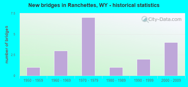
- New bridges - historical statistics
- 11950-1959
- 31960-1969
- 71970-1979
- 11980-1989
- 21990-1999
- 42000-2009


- Bridge Condition - Deck
- 20.0%Very good
- 20.0%Good
- 20.0%Satisfactory
- 20.0%Fair
- 20.0%Poor

- Bridge Condition - Superstructure
- 60.0%Good
- 40.0%Satisfactory

- Bridge Condition - Substructure
- 20.0%Good
- 60.0%Satisfactory
- 20.0%Fair

- Bridge Condition - Channel
- 12.5%Very good
- 12.5%Good
- 75.0%Satisfactory

- Bridge Condition - Culverts
- 16.7%Very good
- 66.7%Good
- 16.7%Satisfactory
Find on map >> Show street view
Structure Number: ABR, Location: Us 85 Jct - Wheatland (Lat: 41.261642, Lng: -104.840950), Route carried "on" structure: Interstate 25, Year Built: 1970, Status: Open, Structure Length: 4.08m (13.39ft), Average Daily Traffic: 3,906 (year 2021), Truck Traffic: 19%, Average Future Daily Traffic: 5,468 (year 2041), Design Load: HS 20+Mod, Features Intersected: La CR 218-2 / Farris Rd
Minimum Vertical Clearance: 30+ m (98+ ft), Kilometerpoint: 30.935, Lanes on structure: 2, Lanes under structure: 2, Base Highway Network: Yes, Owner: State Highway Agency, Approaching Roadway Width: 12.8m (42.0ft), Skew: 11 degrees, Material/Design: Concrete continuous, Design/Construction: Tee Beam, Number Of Spans In Main Unit: 3, Length of Maximum Span: 17.1m (56.1ft), Curb-To-Curb Width: 12.8m (42.0ft), Out-to-Out Width: 13.6m (44.6ft)
Condition: Deck: Good, Superstructure: Good, Substructure: Satisfactory, Operating Rating: 56.2 metric tons, Method Used To Determine Operating Rating: Load Factor (LF), Inventory Rating: 33.6 metric tons, Method Used To Determine Inventory Rating: Load Factor (LF), Structural Evaluation: Equal to present minimum criteria, Deck Geometry: Equal to present desirable criteria, Underclear: Meets minimum limits, Approach Roadway Alignment: Equal to present desirable criteria, Designated Inspection Frequency: Every 24 months, Inspection Date: March 2020, Deck Structure Type: Concrete Cast-file-Place, Wearing Surface/Protective System: Wearing Surface: Epoxy Overlay
Find on map >> Show street view
Structure Number: ABT, Location: Cheyenne - Wheatland (Lat: 41.290797, Lng: -104.851489), Route carried "on" structure: County highway 220-1, Year Built: 1970, Status: Open, Structure Length: 10.47m (34.35ft), Average Daily Traffic: 722 (year 2021), Truck Traffic: 5%, Average Future Daily Traffic: 1,011 (year 2041), Design Load: HS 20+Mod, Features Intersected: I-25
Minimum Vertical Clearance: 30+ m (98+ ft), Kilometerpoint: 4.472, Lanes on structure: 2, Lanes under structure: 4, Owner: State Highway Agency, Approaching Roadway Width: 9.8m (32.2ft), Skew: 1 degrees, Material/Design: Steel continuous, Design/Construction: Stringer/Multi-beam, Number Of Spans In Main Unit: 3, Length of Maximum Span: 35.7m (117.1ft), Curb-To-Curb Width: 9.8m (32.2ft), Out-to-Out Width: 10.6m (34.8ft)
Condition: Deck: Fair, Superstructure: Satisfactory, Substructure: Satisfactory, Operating Rating: 47.2 metric tons, Method Used To Determine Operating Rating: Load Factor (LF), Inventory Rating: 28.1 metric tons, Method Used To Determine Inventory Rating: Load Factor (LF), Structural Evaluation: Equal to present minimum criteria, Deck Geometry: Equal to present minimum criteria, Underclear: Equal to present minimum criteria, Approach Roadway Alignment: Equal to present desirable criteria, Designated Inspection Frequency: Every 24 months, Inspection Date: March 2020, Deck Structure Type: Concrete Cast-file-Place, Wearing Surface/Protective System: Wearing Surface: Latex Concrete
Find on map >> Show street view
Structure Number: CRB, Location: Jct Wyo 219 - West (Lat: 41.218364, Lng: -104.837728), Route carried "on" structure: State highway 211, Year Built: 1961, Status: Open, Structure Length: 6.36m (20.87ft), Average Daily Traffic: 2,789 (year 2021), Truck Traffic: 3%, Average Future Daily Traffic: 3,905 (year 2041), Design Load: HS 20, Features Intersected: I-25
Minimum Vertical Clearance: 30+ m (98+ ft), Kilometerpoint: 0.792, Lanes on structure: 2, Lanes under structure: 4, Owner: State Highway Agency, Approaching Roadway Width: 7.9m (25.9ft), Material/Design: Steel continuous, Design/Construction: Stringer/Multi-beam, Number Of Spans In Main Unit: 4, Length of Maximum Span: 17.1m (56.1ft), Curb-To-Curb Width: 8.5m (27.9ft), Out-to-Out Width: 9.6m (31.5ft)
Condition: Deck: Very good, Superstructure: Good, Substructure: Satisfactory, Operating Rating: 61.7 metric tons, Method Used To Determine Operating Rating: Load Factor (LF), Inventory Rating: 37.2 metric tons, Method Used To Determine Inventory Rating: Load Factor (LF), Structural Evaluation: Equal to present minimum criteria, Deck Geometry: Meets minimum limits, Underclear: Somewhat better than minimum adequacy, Approach Roadway Alignment: Equal to present desirable criteria, Designated Inspection Frequency: Every 24 months, Inspection Date: April 2021, Deck Structure Type: Concrete Cast-file-Place, Wearing Surface/Protective System: Deck Protection: Epoxy Coated Reinforcing
Find on map >> Show street view
Structure Number: DPF, Location: 5 Miles N. Of Cheyenne (Lat: 41.302878, Lng: -104.757853), Route carried "on" structure: County highway 128-2, Year Built: 1973, Status: Open, Structure Length: 1.22m (4.00ft), Average Daily Traffic: 58 (year 2021), Truck Traffic: 9%, Average Future Daily Traffic: 81 (year 2041), Design Load: HS 20, Features Intersected: Lodgepole Creek
Minimum Vertical Clearance: 30+ m (98+ ft), Kilometerpoint: 3.269, Lanes on structure: 2, Owner: County Highway Agency, Approaching Roadway Width: 6.1m (20.0ft), Material/Design: Prestressed concrete, Design/Construction: Tee Beam, Number Of Spans In Main Unit: 1, Length of Maximum Span: 11.6m (38.1ft), Curb-To-Curb Width: 7.1m (23.3ft), Out-to-Out Width: 7.3m (24.0ft)
Condition: Deck: Poor, Superstructure: Satisfactory, Substructure: Fair, Channel: Satisfactory, Operating Rating: 54.5 metric tons, Method Used To Determine Operating Rating: Field evaluation and documented engineering judgment, Inventory Rating: 32.7 metric tons, Method Used To Determine Inventory Rating: Field evaluation and documented engineering judgment, Structural Evaluation: Somewhat better than minimum adequacy, Deck Geometry: Somewhat better than minimum adequacy, Waterway Adequacy: Equal to present desirable criteria, Approach Roadway Alignment: Better than present minimum criteria, Length Of Structure Improvement: 5.79m (19.00ft), Designated Inspection Frequency: Every 24 months, Inspection Date: December 2020, Bridge Improvement Cost: $13,000, Roadway Improvement Cost: $30,000, Total Project Cost: $44,000, Deck Structure Type: Concrete Precast Panels
Find on map >> Show street view
Structure Number: FFH, Location: Cheyenne-Torrington (Lat: 41.293022, Lng: -104.735147), Route carried "on" structure: US 85, Year Built: 1987, Status: Open, Structure Length: 6.28m (20.60ft), Average Daily Traffic: 2,650 (year 2021), Truck Traffic: 12%, Average Future Daily Traffic: 3,710 (year 2041), Design Load: HS 20, Features Intersected: Lodgepole Creek
Minimum Vertical Clearance: 30+ m (98+ ft), Kilometerpoint: 38.283, Lanes on structure: 2, Base Highway Network: Yes (Inventory Route: ML8, Subroute: 1), Owner: State Highway Agency, Approaching Roadway Width: 12.2m (40.0ft), Skew: 2 degrees, Material/Design: Steel continuous, Design/Construction: Stringer/Multi-beam, Number Of Spans In Main Unit: 3, Length of Maximum Span: 24.4m (80.1ft), Curb-To-Curb Width: 12.2m (40.0ft), Out-to-Out Width: 13.1m (43.0ft)
Condition: Deck: Satisfactory, Superstructure: Good, Substructure: Good, Channel: Satisfactory, Operating Rating: 56.8 metric tons, Method Used To Determine Operating Rating: Load Factor (LF), Inventory Rating: 33.9 metric tons, Method Used To Determine Inventory Rating: Load Factor (LF), Structural Evaluation: Better than present minimum criteria, Deck Geometry: Equal to present minimum criteria, Waterway Adequacy: Equal to present desirable criteria, Approach Roadway Alignment: Equal to present desirable criteria, Designated Inspection Frequency: Every 24 months, Inspection Date: April 2021, Deck Structure Type: Concrete Cast-file-Place, Wearing Surface/Protective System: Wearing Surface: Epoxy Overlay, Deck Protection: Epoxy Coated Reinforcing
Find on map >> Show street view
Structure Number: KHA, Location: Ridge Road (Lat: 41.185197, Lng: -104.768083), Route carried "on" structure: County highway 127-1, Year Built: 1996, Status: Open, Structure Length: 1.20m (3.94ft), Average Daily Traffic: 1,227 (year 2021), Truck Traffic: 1%, Average Future Daily Traffic: 1,718 (year 2041), Design Load: HS 20, Features Intersected: Childs Draw
Minimum Vertical Clearance: 30+ m (98+ ft), Kilometerpoint: 6.051, Lanes on structure: 2, Owner: County Highway Agency, Approaching Roadway Width: 11.3m (37.1ft), Material/Design: Concrete, Design/Construction: Culvert, Number Of Spans In Main Unit: 3, Length of Maximum Span: 3.6m (11.8ft)
Condition: Channel: Good, Culverts: Good, Operating Rating: 32.7 metric tons, Method Used To Determine Operating Rating: Field evaluation and documented engineering judgment, Inventory Rating: 32.7 metric tons, Method Used To Determine Inventory Rating: Field evaluation and documented engineering judgment, Structural Evaluation: Better than present minimum criteria, Waterway Adequacy: Equal to present desirable criteria, Approach Roadway Alignment: Equal to present desirable criteria, Designated Inspection Frequency: Every 24 months, Inspection Date: December 2021
Find on map >> Show street view
Structure Number: KHB, Location: Ridge Road (Lat: 41.199647, Lng: -104.767911), Route carried "on" structure: County highway 127-1, Year Built: 1996, Status: Open, Structure Length: 0.93m (3.05ft), Average Daily Traffic: 853 (year 2021), Truck Traffic: 1%, Average Future Daily Traffic: 1,194 (year 2041), Design Load: HS 20, Features Intersected: Unnamed Draw
Minimum Vertical Clearance: 30+ m (98+ ft), Kilometerpoint: 7.656, Lanes on structure: 2, Owner: County Highway Agency, Approaching Roadway Width: 7.6m (24.9ft), Skew: 3 degrees, Material/Design: Concrete, Design/Construction: Culvert, Number Of Spans In Main Unit: 3, Length of Maximum Span: 2.4m (7.9ft)
Condition: Channel: Very good, Culverts: Good, Operating Rating: 32.7 metric tons, Method Used To Determine Operating Rating: Field evaluation and documented engineering judgment, Inventory Rating: 32.7 metric tons, Method Used To Determine Inventory Rating: Field evaluation and documented engineering judgment, Structural Evaluation: Better than present minimum criteria, Waterway Adequacy: Equal to present desirable criteria, Approach Roadway Alignment: Equal to present desirable criteria, Designated Inspection Frequency: Every 24 months, Inspection Date: December 2021
Find on map >> Show street view
Structure Number: MFD, Location: 5 Miles North Of Cheyenne (Lat: 41.251550, Lng: -104.828092), Route carried "on" structure: County highway 124-2, Year Built: 2008, Status: Open, Structure Length: 0.63m (2.07ft), Average Daily Traffic: 1,206 (year 2021), Truck Traffic: 10%, Average Future Daily Traffic: 1,688 (year 2041), Design Load: HS 20, Features Intersected: Nine Mile Draw
Minimum Vertical Clearance: 30+ m (98+ ft), Kilometerpoint: 1.315, Lanes on structure: 2, Owner: County Highway Agency, Approaching Roadway Width: 9.8m (32.2ft), Material/Design: Concrete, Design/Construction: Culvert, Number Of Spans In Main Unit: 2, Length of Maximum Span: 3.0m (9.8ft)
Condition: Channel: Satisfactory, Culverts: Very good, Operating Rating: 54.5 metric tons, Method Used To Determine Operating Rating: Field evaluation and documented engineering judgment, Inventory Rating: 32.7 metric tons, Method Used To Determine Inventory Rating: Field evaluation and documented engineering judgment, Structural Evaluation: Equal to present desirable criteria, Waterway Adequacy: Equal to present desirable criteria, Approach Roadway Alignment: Equal to present desirable criteria, Designated Inspection Frequency: Every 24 months, Inspection Date: December 2020
Find on map >> Show street view
Structure Number: MFE, Location: 6.5 Miles N Of Cheyenne (Lat: 41.272792, Lng: -104.828008), Route carried "on" structure: County highway 124-2, Year Built: 2008, Status: Open, Structure Length: 0.69m (2.26ft), Average Daily Traffic: 1,206 (year 2021), Truck Traffic: 10%, Average Future Daily Traffic: 1,688 (year 2041), Design Load: HS 20, Features Intersected: Nine Mile Draw Tributary
Minimum Vertical Clearance: 30+ m (98+ ft), Kilometerpoint: 3.674, Lanes on structure: 2, Owner: County Highway Agency, Approaching Roadway Width: 9.8m (32.2ft), Material/Design: Concrete, Design/Construction: Culvert, Number Of Spans In Main Unit: 2, Length of Maximum Span: 3.0m (9.8ft)
Condition: Channel: Satisfactory, Culverts: Satisfactory, Operating Rating: 54.5 metric tons, Method Used To Determine Operating Rating: Field evaluation and documented engineering judgment, Inventory Rating: 32.7 metric tons, Method Used To Determine Inventory Rating: Field evaluation and documented engineering judgment, Structural Evaluation: Equal to present minimum criteria, Waterway Adequacy: Equal to present desirable criteria, Approach Roadway Alignment: Equal to present desirable criteria, Length Of Structure Improvement: 0.03m (0.10ft), Designated Inspection Frequency: Every 24 months, Inspection Date: December 2020, Bridge Improvement Cost: $1,000, Roadway Improvement Cost: $1,000, Total Project Cost: $3,000
Find on map >> Show street view
Structure Number: MFF, Location: 6.6 Mi North Of Cheyenne (Lat: 41.288764, Lng: -104.827942), Route carried "on" structure: County highway 124-2, Year Built: 2008, Status: Open, Structure Length: 0.63m (2.07ft), Average Daily Traffic: 1,206 (year 2021), Truck Traffic: 10%, Average Future Daily Traffic: 1,688 (year 2041), Design Load: HS 20, Features Intersected: Lodgepole Creek Trib
Minimum Vertical Clearance: 30+ m (98+ ft), Kilometerpoint: 5.448, Lanes on structure: 2, Owner: County Highway Agency, Approaching Roadway Width: 9.8m (32.2ft), Material/Design: Concrete, Design/Construction: Culvert, Number Of Spans In Main Unit: 2, Length of Maximum Span: 3.0m (9.8ft)
Condition: Channel: Satisfactory, Culverts: Good, Operating Rating: 54.5 metric tons, Method Used To Determine Operating Rating: Field evaluation and documented engineering judgment, Inventory Rating: 32.7 metric tons, Method Used To Determine Inventory Rating: Field evaluation and documented engineering judgment, Structural Evaluation: Better than present minimum criteria, Waterway Adequacy: Equal to present desirable criteria, Approach Roadway Alignment: Equal to present desirable criteria, Length Of Structure Improvement: 0.15m (0.49ft), Designated Inspection Frequency: Every 24 months, Inspection Date: December 2020, Bridge Improvement Cost: $1,000, Roadway Improvement Cost: $1,000, Total Project Cost: $3,000
Find on map >> Show street view
Structure Number: MFG, Location: 8 Mi N Of Cheyenne (Lat: 41.296967, Lng: -104.827872), Route carried "on" structure: County highway 124-2, Year Built: 2008, Status: Open, Structure Length: 0.69m (2.26ft), Average Daily Traffic: 1,206 (year 2021), Truck Traffic: 10%, Average Future Daily Traffic: 1,688 (year 2041), Design Load: HS 20, Features Intersected: Lodgepole Creek Trib
Minimum Vertical Clearance: 30+ m (98+ ft), Kilometerpoint: 6.359, Lanes on structure: 2, Owner: County Highway Agency, Approaching Roadway Width: 9.8m (32.2ft), Material/Design: Concrete, Design/Construction: Culvert, Number Of Spans In Main Unit: 2, Length of Maximum Span: 3.0m (9.8ft)
Condition: Channel: Satisfactory, Culverts: Good, Operating Rating: 54.5 metric tons, Method Used To Determine Operating Rating: Field evaluation and documented engineering judgment, Inventory Rating: 32.7 metric tons, Method Used To Determine Inventory Rating: Field evaluation and documented engineering judgment, Structural Evaluation: Better than present minimum criteria, Waterway Adequacy: Equal to present desirable criteria, Approach Roadway Alignment: Equal to present desirable criteria, Designated Inspection Frequency: Every 24 months, Inspection Date: December 2020
Find on map >> Show street view
Structure Number: ABQ, Location: Us 85 Jct - Wheatland (Lat: 41.232581, Lng: -104.837644), Route carried "under" structure: Ramp US 85, Year Built: 1957, Structure Length: 0. m, Average Daily Traffic: 1,498 (year 2021), Truck Traffic: 19%, Features Intersected: US 85, Facility Carried by Structure: I-25 NBL
Minimum Vertical Clearance: 5.18m (16.99ft), Kilometerpoint: 0.356, Lanes on structure: 2, Lanes under structure: 1, Material/Design: Concrete continuous, Design/Construction: Tee Beam, Length of Maximum Span: 27.4m (89.9ft)
Find on map >> Show street view
Structure Number: ABR, Location: Us 85 Jct - Wheatland (Lat: 41.261642, Lng: -104.840950), Route carried "under" structure: County highway 218-2, Year Built: 1970, Structure Length: 0. m, Average Daily Traffic: 722 (year 2021), Truck Traffic: 5%, Features Intersected: La CR 218-2 / Farris Rd, Facility Carried by Structure: I-25 NBL
Minimum Vertical Clearance: 5.15m (16.90ft), Kilometerpoint: 5.518, Lanes on structure: 2, Lanes under structure: 2, Material/Design: Concrete continuous, Design/Construction: Tee Beam, Length of Maximum Span: 17.1m (56.1ft)
Find on map >> Show street view
Structure Number: ABS, Location: Us 85 Jct - Wheatland (Lat: 41.261631, Lng: -104.841533), Route carried "under" structure: County highway 218-2, Year Built: 1970, Structure Length: 0. m, Average Daily Traffic: 722 (year 2021), Truck Traffic: 5%, Features Intersected: La CR 218-2 / Farris Rd, Facility Carried by Structure: I-25 SBL
Minimum Vertical Clearance: 4.42m (14.50ft), Kilometerpoint: 5.470, Lanes on structure: 2, Lanes under structure: 2, Material/Design: Concrete continuous, Design/Construction: Tee Beam, Length of Maximum Span: 17.1m (56.1ft)
Find on map >> Show street view
Structure Number: ABT, Location: Cheyenne - Wheatland (Lat: 41.290797, Lng: -104.851489), Route carried "under" structure: Interstate 25, Year Built: 1970, Structure Length: 0. m, Average Daily Traffic: 3,847 (year 2021), Truck Traffic: 57%, Features Intersected: I-25, Facility Carried by Structure: La Cnty Rd 220-1
Minimum Vertical Clearance: 5.51m (18.08ft), Kilometerpoint: 34.269, Lanes on structure: 2, Lanes under structure: 2, Material/Design: Steel continuous, Design/Construction: Stringer/Multi-beam, Length of Maximum Span: 35.7m (117.1ft)
Find on map >> Show street view
Structure Number: ABT, Location: Cheyenne - Wheatland (Lat: 41.290797, Lng: -104.851489), Route carried "under" structure: Interstate 25, Year Built: 1970, Structure Length: 0. m, Average Daily Traffic: 3,870 (year 2021), Truck Traffic: 20%, Features Intersected: I-25, Facility Carried by Structure: La Cnty Rd 220-1
Minimum Vertical Clearance: 5.51m (18.08ft), Kilometerpoint: 34.281, Lanes on structure: 2, Lanes under structure: 2, Material/Design: Steel continuous, Design/Construction: Stringer/Multi-beam, Length of Maximum Span: 35.7m (117.1ft)
Find on map >> Show street view
Structure Number: CRB, Location: Jct Wyo 219 - West (Lat: 41.218364, Lng: -104.837728), Route carried "under" structure: Interstate 25, Year Built: 1961, Structure Length: 0. m, Average Daily Traffic: 5,108 (year 2021), Truck Traffic: 18%, Features Intersected: I-25, Facility Carried by Structure: WYO 211
Minimum Vertical Clearance: 5.18m (16.99ft), Kilometerpoint: 26.100, Lanes on structure: 2, Lanes under structure: 2, Material/Design: Steel continuous, Design/Construction: Stringer/Multi-beam, Length of Maximum Span: 17.1m (56.1ft)
Find on map >> Show street view
Structure Number: CRB, Location: Jct Wyo 219 - West (Lat: 41.218364, Lng: -104.837728), Route carried "under" structure: Interstate 25, Year Built: 1961, Structure Length: 0. m, Average Daily Traffic: 5,199 (year 2021), Truck Traffic: 18%, Features Intersected: I-25, Facility Carried by Structure: WYO 211
Minimum Vertical Clearance: 5.29m (17.36ft), Kilometerpoint: 26.100, Lanes on structure: 2, Lanes under structure: 2, Material/Design: Steel continuous, Design/Construction: Stringer/Multi-beam, Length of Maximum Span: 17.1m (56.1ft)