Bridge Statistics for Racine, West Virginia (WV)
Condition, Traffic, Stress, Structural Evaluation, Project Costs
- National Bridge Inventory (NBI) Statistics
- 12Number of bridges
- 115ft / 35.3mTotal length
- $1,150,000Total costs
- 38,642Total average daily traffic
- 3,195Total average daily truck traffic
- National Bridge Inventory (NBI) Registered Bridges for Racine
- No street view available for this location
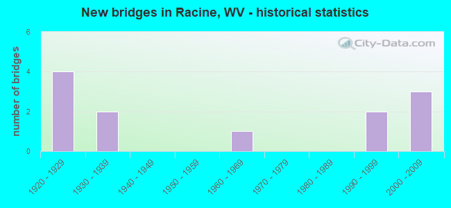
- New bridges - historical statistics
- 41920-1929
- 21930-1939
- 11960-1969
- 21990-1999
- 32000-2009
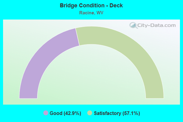
- Bridge Condition - Deck
- 42.9%Good
- 57.1%Satisfactory
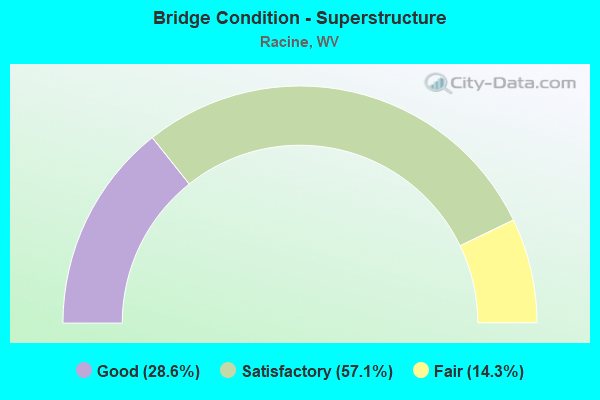
- Bridge Condition - Superstructure
- 28.6%Good
- 57.1%Satisfactory
- 14.3%Fair
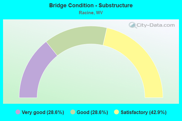
- Bridge Condition - Substructure
- 28.6%Very good
- 28.6%Good
- 42.9%Satisfactory
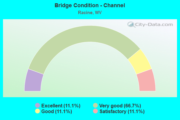
- Bridge Condition - Channel
- 11.1%Excellent
- 66.7%Very good
- 11.1%Good
- 11.1%Satisfactory
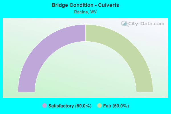
- Bridge Condition - Culverts
- 50.0%Satisfactory
- 50.0%Fair
Find on map >> Show street view
Structure Number: 3A006, Location: 0.05 MI S CR 1 (Lat: 38.164439, Lng: -81.712419), Route carried "on" structure: County highway 12, Year Built: 1990, Status: Open, Structure Length: 1.26m (4.13ft), Average Daily Traffic: 500 (year 2018), Truck Traffic: 6%, Average Future Daily Traffic: 615 (year 2038), Design Load: HS 25 or greater, Features Intersected: BRUSH CREEK, Facility Carried by Structure: COUNTY ROUTE 1/2
Minimum Vertical Clearance: 30+ m (98+ ft), Kilometerpoint: 6.341, Lanes on structure: 2, Owner: State Highway Agency, Approaching Roadway Width: 5.5m (18.0ft), Material/Design: Prestressed concrete, Design/Construction: Box Beam or Girders - Multiple, Number Of Spans In Main Unit: 1, Length of Maximum Span: 12.2m (40.0ft), Curb-To-Curb Width: 5.5m (18.0ft), Out-to-Out Width: 5.5m (18.0ft)
Condition: Deck: Satisfactory, Superstructure: Satisfactory, Substructure: Satisfactory, Channel: Good, Operating Rating: 88.9 metric tons, Method Used To Determine Operating Rating: Load Factor (LF), Inventory Rating: 65.3 metric tons, Method Used To Determine Inventory Rating: Load Factor (LF), Structural Evaluation: Equal to present minimum criteria, Deck Geometry: High priority of replacement, Waterway Adequacy: Equal to present desirable criteria, Approach Roadway Alignment: Better than present minimum criteria, Designated Inspection Frequency: Every 24 months, Inspection Date: Febuary 2021, Deck Structure Type: Other, Wearing Surface/Protective System: Wearing Surface: Bituminous, Deck Protection: Epoxy Coated Reinforcing
Find on map >> Show street view
Structure Number: 3A016, Location: 0.04 MI W OF CR 3/2 (Lat: 38.143069, Lng: -81.633450), Route carried "on" structure: State highway 3, Year Built: 1995, Status: Open, Structure Length: 2.04m (6.69ft), Average Daily Traffic: 4,200 (year 2020), Truck Traffic: 9%, Average Future Daily Traffic: 5,166 (year 2040), Design Load: HS 25 or greater, Features Intersected: TONY CREEK
Minimum Vertical Clearance: 30+ m (98+ ft), Kilometerpoint: 38.125, Lanes on structure: 2, Owner: State Highway Agency, Approaching Roadway Width: 7.3m (24.0ft), Material/Design: Steel, Design/Construction: Stringer/Multi-beam, Number Of Spans In Main Unit: 1, Length of Maximum Span: 19.5m (64.0ft), Curb-To-Curb Width: 12.2m (40.0ft), Out-to-Out Width: 13.3m (43.6ft)
Condition: Deck: Good, Superstructure: Good, Substructure: Good, Channel: Very good, Operating Rating: 88.9 metric tons, Method Used To Determine Operating Rating: Load Factor (LF), Inventory Rating: 62.6 metric tons, Method Used To Determine Inventory Rating: Load Factor (LF), Structural Evaluation: Better than present minimum criteria, Deck Geometry: Equal to present minimum criteria, Waterway Adequacy: Superior to present desirable criteria, Approach Roadway Alignment: Better than present minimum criteria, Designated Inspection Frequency: Every 24 months, Inspection Date: July 2021, Deck Structure Type: Concrete Cast-file-Place, Wearing Surface/Protective System: Wearing Surface: Monolithic Concrete, Deck Protection: Epoxy Coated Reinforcing
Find on map >> Show street view
Structure Number: 3A03, Location: 0.03 MI N OF CR 3/16 (Lat: 38.143361, Lng: -81.637669), Route carried "on" structure: County highway 313, Year Built: 1964, Year Reconstructed: 1999, Status: Open, Structure Length: 6.93m (22.74ft), Average Daily Traffic: 30 (year 2020), Truck Traffic: 8%, Average Future Daily Traffic: 40 (year 2040), Design Load: HS 25 or greater, Features Intersected: BIG COAL RIVER, Facility Carried by Structure: COUNTY ROUTE 3/13
Minimum Vertical Clearance: 30+ m (98+ ft), Kilometerpoint: 0.064, Lanes on structure: 1, Owner: State Highway Agency, Approaching Roadway Width: 4.9m (16.1ft), Skew: 1 degrees, Material/Design: Steel, Design/Construction: Girder and Floorbeam System, Number Of Spans In Main Unit: 2, Number Of Approach Spans: 1, Length of Maximum Span: 22.6m (74.1ft), Curb or Sidewalk Widths: Left: 0.2m (0.7ft), Right: 0.2m (0.7ft), Curb-To-Curb Width: 4.6m (15.1ft), Out-to-Out Width: 4.9m (16.1ft)
Condition: Deck: Satisfactory, Superstructure: Fair, Substructure: Satisfactory, Channel: Satisfactory, Operating Rating: 50.8 metric tons, Method Used To Determine Operating Rating: Load Factor (LF), Inventory Rating: 29.9 metric tons, Method Used To Determine Inventory Rating: Load Factor (LF), Structural Evaluation: Somewhat better than minimum adequacy, Deck Geometry: Better than present minimum criteria, Waterway Adequacy: Equal to present desirable criteria, Approach Roadway Alignment: Equal to present minimum criteria, Length Of Structure Improvement: 6.93m (22.74ft), Designated Inspection Frequency: Every 24 months, Inspection Date: June 2021, Bridge Improvement Cost: $200,000, Roadway Improvement Cost: $50,000, Total Project Cost: $250,000 ( Estimate for 2019), Deck Structure Type: Wood or Timber, Wearing Surface/Protective System: Wearing Surface: Bituminous
Find on map >> Show street view
Structure Number: 3A089, Location: 2.03 MI E OF CR 119/22 (Lat: 38.117839, Lng: -81.692431), Route carried "on" structure: State highway 3, Year Built: 1933, Status: Posted for load, Structure Length: 1.16m (3.81ft), Average Daily Traffic: 4,712 (year 2018), Truck Traffic: 9%, Average Future Daily Traffic: 5,796 (year 2038), Features Intersected: DRAWDY CREEK
Minimum Vertical Clearance: 30+ m (98+ ft), Kilometerpoint: 29.950, Lanes on structure: 2, Owner: State Highway Agency, Approaching Roadway Width: 6.4m (21.0ft), Skew: 3 degrees, Material/Design: Concrete, Design/Construction: Tee Beam, Number Of Spans In Main Unit: 1, Length of Maximum Span: 10.7m (35.1ft), Curb or Sidewalk Widths: Left: 0.2m (0.7ft), Right: 0.2m (0.7ft), Curb-To-Curb Width: 9.1m (29.9ft), Out-to-Out Width: 10.1m (33.1ft)
Condition: Deck: Satisfactory, Superstructure: Satisfactory, Substructure: Satisfactory, Channel: Very good, Operating Rating: 43.5 metric tons, Method Used To Determine Operating Rating: Load Factor (LF), Inventory Rating: 26.3 metric tons, Method Used To Determine Inventory Rating: Load Factor (LF), Structural Evaluation: Equal to present minimum criteria, Deck Geometry: Meets minimum limits, Waterway Adequacy: Equal to present minimum criteria, Approach Roadway Alignment: Equal to present desirable criteria, Bridge Posting: Required (Relationship of Operating Rating to Maximum Legal Load: 10.0 - 19.9% below), Length Of Structure Improvement: 1.16m (3.81ft), Designated Inspection Frequency: Every 24 months, Inspection Date: June 2020, Bridge Improvement Cost: $700,000, Roadway Improvement Cost: $50,000, Total Project Cost: $750,000 ( Estimate for 2020), Deck Structure Type: Concrete Cast-file-Place, Wearing Surface/Protective System: Wearing Surface: Bituminous
Find on map >> Show street view
Structure Number: 3A09, Location: 3.20 MI E OF CR 119/22 (Lat: 38.133769, Lng: -81.688511), Route carried "on" structure: State highway 3, Year Built: 1933, Status: Open, Structure Length: 1.07m (3.51ft), Average Daily Traffic: 3,600 (year 2018), Truck Traffic: 9%, Average Future Daily Traffic: 4,428 (year 2038), Features Intersected: DRAWDY CREEK
Minimum Vertical Clearance: 30+ m (98+ ft), Kilometerpoint: 31.833, Lanes on structure: 2, Owner: State Highway Agency, Approaching Roadway Width: 6.7m (22.0ft), Skew: 1 degrees, Material/Design: Concrete, Design/Construction: Culvert, Number Of Spans In Main Unit: 1, Length of Maximum Span: 10.7m (35.1ft)
Condition: Channel: Very good, Culverts: Satisfactory, Operating Rating: 63.5 metric tons, Method Used To Determine Operating Rating: Field evaluation and documented engineering judgment, Inventory Rating: 29.0 metric tons, Method Used To Determine Inventory Rating: Field evaluation and documented engineering judgment, Structural Evaluation: Equal to present minimum criteria, Waterway Adequacy: Superior to present desirable criteria, Approach Roadway Alignment: Equal to present desirable criteria, Length Of Structure Improvement: 1.07m (3.51ft), Designated Inspection Frequency: Every 24 months, Inspection Date: July 2020, Bridge Improvement Cost: $145,000, Roadway Improvement Cost: $5,000, Total Project Cost: $150,000 ( Estimate for 2020)
Find on map >> Show street view
Structure Number: 3A093, Location: 0.01 MI N OF WV 3 (Lat: 38.142850, Lng: -81.658939), Route carried "on" structure: State highway 94, Year Built: 1929, Status: Open, Structure Length: 0.85m (2.79ft), Average Daily Traffic: 5,600 (year 2018), Truck Traffic: 9%, Average Future Daily Traffic: 6,888 (year 2038), Features Intersected: SHORT CREEK
Minimum Vertical Clearance: 30+ m (98+ ft), Kilometerpoint: 0.016, Lanes on structure: 4, Owner: State Highway Agency, Approaching Roadway Width: 6.1m (20.0ft), Skew: 4 degrees, Material/Design: Concrete, Design/Construction: Culvert, Number Of Spans In Main Unit: 1, Length of Maximum Span: 8.5m (27.9ft)
Condition: Channel: Very good, Culverts: Fair, Operating Rating: 63.5 metric tons, Method Used To Determine Operating Rating: Field evaluation and documented engineering judgment, Inventory Rating: 29.0 metric tons, Method Used To Determine Inventory Rating: Field evaluation and documented engineering judgment, Structural Evaluation: Somewhat better than minimum adequacy, Waterway Adequacy: Superior to present desirable criteria, Approach Roadway Alignment: Somewhat better than minimum adequacy, Designated Inspection Frequency: Every 24 months, Inspection Date: July 2020
Find on map >> Show street view
Structure Number: 3A169, Location: 0.01 MILE EAST OF WV 3 (Lat: 38.142639, Lng: -81.660511), Route carried "on" structure: County highway 325, Year Built: 2000, Status: Open, Structure Length: 8.02m (26.31ft), Average Daily Traffic: 500 (year 2018), Truck Traffic: 6%, Average Future Daily Traffic: 615 (year 2038), Design Load: HS 25 or greater, Features Intersected: BIG COAL RIVER, Facility Carried by Structure: CR 3/25
Minimum Vertical Clearance: 30+ m (98+ ft), Kilometerpoint: 0.016, Lanes on structure: 2, Owner: State Highway Agency, Approaching Roadway Width: 11.6m (38.1ft), Material/Design: Prestressed concrete, Design/Construction: Stringer/Multi-beam, Number Of Spans In Main Unit: 2, Length of Maximum Span: 39.6m (129.9ft), Curb-To-Curb Width: 8.6m (28.2ft), Out-to-Out Width: 9.4m (30.8ft)
Condition: Deck: Good, Superstructure: Satisfactory, Substructure: Good, Channel: Very good, Operating Rating: 35.4 metric tons, Method Used To Determine Operating Rating: Load Factor (LF), Inventory Rating: 20.9 metric tons, Method Used To Determine Inventory Rating: Load Factor (LF), Structural Evaluation: Equal to present minimum criteria, Deck Geometry: Somewhat better than minimum adequacy, Waterway Adequacy: Superior to present desirable criteria, Approach Roadway Alignment: Equal to present minimum criteria, Designated Inspection Frequency: Every 24 months, Inspection Date: September 2020, Deck Structure Type: Concrete Cast-file-Place, Wearing Surface/Protective System: Wearing Surface: Monolithic Concrete, Deck Protection: Epoxy Coated Reinforcing
Find on map >> Show street view
Structure Number: 3A17, Location: 0.01 MILE W OF CR 119/21 (Lat: 38.136639, Lng: -81.679211), Route carried "on" structure: State highway 3, Year Built: 2000, Status: Open, Structure Length: 9.60m (31.50ft), Average Daily Traffic: 3,600 (year 2018), Truck Traffic: 5%, Average Future Daily Traffic: 4,392 (year 2038), Design Load: HS 25 or greater, Features Intersected: BIG COAL RIVER
Minimum Vertical Clearance: 30+ m (98+ ft), Kilometerpoint: 32.702, Lanes on structure: 2, Owner: State Highway Agency, Approaching Roadway Width: 8.8m (28.9ft), Skew: 3 degrees, Material/Design: Steel continuous, Design/Construction: Stringer/Multi-beam, Number Of Spans In Main Unit: 1, Number Of Approach Spans: 2, Length of Maximum Span: 39.0m (128.0ft), Curb-To-Curb Width: 9.0m (29.5ft), Out-to-Out Width: 9.5m (31.2ft)
Condition: Deck: Satisfactory, Superstructure: Satisfactory, Substructure: Very good, Channel: Excellent, Operating Rating: 57.1 metric tons, Method Used To Determine Operating Rating: Load Factor (LF), Inventory Rating: 34.5 metric tons, Method Used To Determine Inventory Rating: Load Factor (LF), Structural Evaluation: Equal to present minimum criteria, Deck Geometry: Meets minimum limits, Waterway Adequacy: Superior to present desirable criteria, Approach Roadway Alignment: Equal to present desirable criteria, Designated Inspection Frequency: Every 24 months, Inspection Date: September 2020, Deck Structure Type: Concrete Cast-file-Place, Wearing Surface/Protective System: Wearing Surface: Monolithic Concrete, Deck Protection: Epoxy Coated Reinforcing
Find on map >> Show street view
Structure Number: 3A176, Location: 0.03 MI E OF CR 1/2 (Lat: 38.136169, Lng: -81.682011), Route carried "on" structure: State highway 3, Year Built: 2004, Status: Open, Structure Length: 4.34m (14.24ft), Average Daily Traffic: 3,600 (year 2018), Truck Traffic: 6%, Average Future Daily Traffic: 4,428 (year 2038), Design Load: HL 93, Features Intersected: DRAWDY CREEK
Minimum Vertical Clearance: 30+ m (98+ ft), Kilometerpoint: 32.477, Lanes on structure: 2, Owner: State Highway Agency, Approaching Roadway Width: 8.5m (27.9ft), Skew: 4 degrees, Material/Design: Steel continuous, Design/Construction: Stringer/Multi-beam, Number Of Spans In Main Unit: 2, Length of Maximum Span: 21.0m (68.9ft), Curb-To-Curb Width: 9.1m (29.9ft), Out-to-Out Width: 9.9m (32.5ft)
Condition: Deck: Good, Superstructure: Good, Substructure: Very good, Channel: Very good, Operating Rating: 49.0 metric tons, Method Used To Determine Operating Rating: Load and Resistance Factor (LRFR), Inventory Rating: 37.2 metric tons, Method Used To Determine Inventory Rating: Load and Resistance Factor (LRFR), Structural Evaluation: Better than present minimum criteria, Deck Geometry: Meets minimum limits, Waterway Adequacy: Equal to present desirable criteria, Approach Roadway Alignment: Equal to present minimum criteria, Designated Inspection Frequency: Every 24 months, Inspection Date: July 2020, Deck Structure Type: Concrete Cast-file-Place, Wearing Surface/Protective System: Wearing Surface: Monolithic Concrete, Deck Protection: Epoxy Coated Reinforcing
Find on map >> Show street view
Structure Number: 3A192, Location: 1.4 MILES WEST OF CR 1/2 (Lat: 38.119881, Lng: -81.692411), Route carried "under" structure: State highway 300, Year Built: 1925, Structure Length: 0. m, Average Daily Traffic: 4,100 (year 2019), Truck Traffic: 9%, Features Intersected: . 3, Facility Carried by Structure: ALPHA NATURAL RES.
Minimum Vertical Clearance: 19.00m (62.34ft), Kilometerpoint: 29.966, Lanes under structure: 2, Material/Design: Steel, Length of Maximum Span: 32.0m (105.0ft)
Find on map >> Show street view
Structure Number: 3A193, Location: 1.4 MILES WEST OF CR 1/2 (Lat: 38.119331, Lng: -81.692431), Route carried "under" structure: State highway 3, Year Built: 1925, Structure Length: 0. m, Average Daily Traffic: 4,100 (year 2019), Truck Traffic: 9%, Features Intersected: . 3, Facility Carried by Structure: ALPHA NATURAL RES.
Minimum Vertical Clearance: 6.22m (20.41ft), Kilometerpoint: 29.966, Lanes under structure: 2, Material/Design: Steel, Length of Maximum Span: 33.5m (109.9ft)
Find on map >> Show street view
Structure Number: 3A194, Location: 1.4 MILES WEST OF CR 1/2 (Lat: 38.119319, Lng: -81.692400), Route carried "under" structure: State highway 3, Year Built: 1925, Structure Length: 0. m, Average Daily Traffic: 4,100 (year 2019), Truck Traffic: 9%, Features Intersected: . 3, Facility Carried by Structure: ALPHA NATURAL RES.
Minimum Vertical Clearance: 6.81m (22.34ft), Kilometerpoint: 29.966, Lanes under structure: 2, Material/Design: Steel, Length of Maximum Span: 33.5m (109.9ft)