Bridge Statistics for Rachel, West Virginia (WV)
Condition, Traffic, Stress, Structural Evaluation, Project Costs
- National Bridge Inventory (NBI) Statistics
- 10Number of bridges
- 75ft / 23.1mTotal length
- $2,587,000Total costs
- 5,150Total average daily traffic
- 435Total average daily truck traffic
- 6,635Total future (year 2037) average daily traffic
- National Bridge Inventory (NBI) Registered Bridges for Rachel
- No street view available for this location
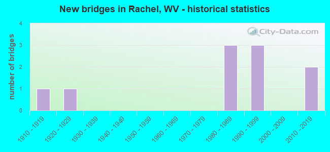
- New bridges - historical statistics
- 11910-1919
- 11920-1929
- 31980-1989
- 31990-1999
- 22010-2019

- Bridge Condition - Deck
- 60.0%Good
- 20.0%Fair
- 20.0%Poor

- Bridge Condition - Superstructure
- 11.1%Very good
- 33.3%Good
- 11.1%Satisfactory
- 22.2%Fair
- 22.2%Poor

- Bridge Condition - Substructure
- 12.5%Very good
- 75.0%Good
- 12.5%Satisfactory

- Bridge Condition - Channel
- 11.1%Good
- 55.6%Satisfactory
- 22.2%Fair
- 11.1%Poor
Find on map >> Show street view
Structure Number: 25A037, Location: 0.49 MI SOUTH CO RT 18/4 (Lat: 39.546700, Lng: -80.285400), Route carried "on" structure: County highway 1800, Year Built: 1985, Status: Open, Structure Length: 1.38m (4.53ft), Average Daily Traffic: 350 (year 2018), Truck Traffic: 9%, Average Future Daily Traffic: 425 (year 2038), Design Load: HS 20, Features Intersected: PLUM RUN, Facility Carried by Structure: MARION CO RT 18
Minimum Vertical Clearance: 30+ m (98+ ft), Kilometerpoint: 3.782, Lanes on structure: 2, Owner: State Highway Agency, Approaching Roadway Width: 5.8m (19.0ft), Skew: 4 degrees, Material/Design: Steel, Design/Construction: Stringer/Multi-beam, Number Of Spans In Main Unit: 1, Length of Maximum Span: 12.2m (40.0ft), Curb-To-Curb Width: 6.7m (22.0ft), Out-to-Out Width: 7.5m (24.6ft)
Condition: Deck: Good, Superstructure: Good, Substructure: Good, Channel: Satisfactory, Operating Rating: 68.0 metric tons, Method Used To Determine Operating Rating: Load Factor (LF), Inventory Rating: 40.8 metric tons, Method Used To Determine Inventory Rating: Load Factor (LF), Structural Evaluation: Better than present minimum criteria, Deck Geometry: Meets minimum limits, Waterway Adequacy: Better than present minimum criteria, Approach Roadway Alignment: Equal to present minimum criteria, Designated Inspection Frequency: Every 48 months, Inspection Date: December 2019, Deck Structure Type: Concrete Cast-file-Place, Wearing Surface/Protective System: Deck Protection: Epoxy Coated Reinforcing
Find on map >> Show street view
Structure Number: 25A039, Location: 0.18 MI SOUTH CO RT 18/1 (Lat: 39.559189, Lng: -80.283150), Route carried "on" structure: County highway 1800, Year Built: 1925, Status: Posted for load, Structure Length: 0.93m (3.05ft), Average Daily Traffic: 350 (year 2018), Truck Traffic: 9%, Average Future Daily Traffic: 425 (year 2038), Features Intersected: PLUM RUN, Facility Carried by Structure: MARION COUNTY 18
Minimum Vertical Clearance: 30+ m (98+ ft), Kilometerpoint: 5.407, Lanes on structure: 2, Owner: State Highway Agency, Approaching Roadway Width: 4.9m (16.1ft), Skew: 4 degrees, Material/Design: Concrete, Design/Construction: Arch - Deck, Number Of Spans In Main Unit: 1, Length of Maximum Span: 9.3m (30.5ft), Curb-To-Curb Width: 5.1m (16.7ft), Out-to-Out Width: 5.7m (18.7ft)
Condition: Superstructure: Poor, Channel: Poor, Operating Rating: 42.6 metric tons, Method Used To Determine Operating Rating: Field evaluation and documented engineering judgment, Inventory Rating: 20.0 metric tons, Method Used To Determine Inventory Rating: Field evaluation and documented engineering judgment, Structural Evaluation: Meets minimum limits, Deck Geometry: High priority of replacement, Waterway Adequacy: Somewhat better than minimum adequacy, Approach Roadway Alignment: Better than present minimum criteria, Length Of Structure Improvement: 1.01m (3.31ft), Designated Inspection Frequency: Every 24 months, Inspection Date: March 2020, Bridge Improvement Cost: $234,000, Roadway Improvement Cost: $195,000, Total Project Cost: $474,000 ( Estimate for 2020)
Find on map >> Show street view
Structure Number: 25A102, Location: 0.02 MI NORTH CO RT 44/11 (Lat: 39.516439, Lng: -80.304250), Route carried "on" structure: County highway 4400, Year Built: 1982, Status: Open, Structure Length: 3.82m (12.53ft), Average Daily Traffic: 1,200 (year 2018), Truck Traffic: 9%, Average Future Daily Traffic: 1,475 (year 2038), Design Load: HS 20, Features Intersected: BUFFALO CREEK, Facility Carried by Structure: MARION CO RT 44
Minimum Vertical Clearance: 30+ m (98+ ft), Kilometerpoint: 10.445, Lanes on structure: 2, Owner: State Highway Agency, Approaching Roadway Width: 6.4m (21.0ft), Material/Design: Prestressed concrete, Design/Construction: Box Beam or Girders - Multiple, Number Of Spans In Main Unit: 2, Length of Maximum Span: 18.3m (60.0ft), Curb-To-Curb Width: 5.0m (16.4ft), Out-to-Out Width: 5.6m (18.4ft)
Condition: Superstructure: Fair, Substructure: Good, Channel: Fair, Operating Rating: 59.0 metric tons, Method Used To Determine Operating Rating: Load Factor (LF), Inventory Rating: 35.4 metric tons, Method Used To Determine Inventory Rating: Load Factor (LF), Structural Evaluation: Somewhat better than minimum adequacy, Deck Geometry: High priority of replacement, Waterway Adequacy: Better than present minimum criteria, Approach Roadway Alignment: Somewhat better than minimum adequacy, Length Of Structure Improvement: 3.81m (12.50ft), Designated Inspection Frequency: Every 24 months, Inspection Date: December 2020, Bridge Improvement Cost: $335,000, Roadway Improvement Cost: $272,000, Total Project Cost: $728,000 ( Estimate for 2021), Deck Structure Type: Other, Wearing Surface/Protective System: Deck Protection: Epoxy Coated Reinforcing
Find on map >> Show street view
Structure Number: 25A107, Location: 0.07 MI NORTH US RT 250 (Lat: 39.505881, Lng: -80.285381), Route carried "on" structure: County highway 5000, Year Built: 1996, Status: Open, Structure Length: 3.99m (13.09ft), Average Daily Traffic: 250 (year 2018), Truck Traffic: 9%, Average Future Daily Traffic: 300 (year 2038), Design Load: HS 25 or greater, Features Intersected: BUFFALO CREEK, Facility Carried by Structure: MARION CO RT 50
Minimum Vertical Clearance: 30+ m (98+ ft), Kilometerpoint: 5.005, Lanes on structure: 2, Owner: State Highway Agency, Approaching Roadway Width: 4.0m (13.1ft), Material/Design: Steel continuous, Design/Construction: Stringer/Multi-beam, Number Of Spans In Main Unit: 2, Length of Maximum Span: 19.5m (64.0ft), Curb-To-Curb Width: 7.0m (23.0ft), Out-to-Out Width: 8.1m (26.6ft)
Condition: Deck: Good, Superstructure: Very good, Substructure: Good, Channel: Satisfactory, Operating Rating: 88.9 metric tons, Method Used To Determine Operating Rating: Load Factor (LF), Inventory Rating: 64.4 metric tons, Method Used To Determine Inventory Rating: Load Factor (LF), Structural Evaluation: Better than present minimum criteria, Deck Geometry: Meets minimum limits, Waterway Adequacy: Better than present minimum criteria, Approach Roadway Alignment: Meets minimum limits, Designated Inspection Frequency: Every 48 months, Underwater Inspection Frequency: Every 60 months, Inspection Date: August 2020, Underwater Inspection Date: June 2021, Deck Structure Type: Concrete Cast-file-Place, Wearing Surface/Protective System: Deck Protection: Epoxy Coated Reinforcing
Find on map >> Show street view
Structure Number: 25A162, Location: 0.02 MI EAST CO RT 91/4 (Lat: 39.519450, Lng: -80.305300), Route carried "on" structure: County highway 9100, Year Built: 1995, Status: Open, Structure Length: 0.80m (2.62ft), Average Daily Traffic: 650 (year 2019), Truck Traffic: 8%, Average Future Daily Traffic: 1,000 (year 2041), Design Load: HS 25 or greater, Features Intersected: MOD RUN, Facility Carried by Structure: MARION CO RT 91
Minimum Vertical Clearance: 30+ m (98+ ft), Kilometerpoint: 2.157, Lanes on structure: 2, Owner: State Highway Agency, Approaching Roadway Width: 7.6m (24.9ft), Skew: 1 degrees, Material/Design: Concrete continuous, Design/Construction: Culvert, Number Of Spans In Main Unit: 2, Length of Maximum Span: 3.9m (12.8ft)
Condition: Channel: Satisfactory, Culverts: Good, Operating Rating: 88.9 metric tons, Method Used To Determine Operating Rating: Field evaluation and documented engineering judgment, Inventory Rating: 40.8 metric tons, Method Used To Determine Inventory Rating: Field evaluation and documented engineering judgment, Structural Evaluation: Better than present minimum criteria, Waterway Adequacy: Equal to present desirable criteria, Approach Roadway Alignment: Equal to present minimum criteria, Designated Inspection Frequency: Every 48 months, Inspection Date: May 2021
Find on map >> Show street view
Structure Number: 25A163, Location: 0.01 MI WEST CO RT 18 (Lat: 39.515600, Lng: -80.285539), Route carried "on" structure: County highway 9100, Year Built: 1911, Status: Posted for load, Structure Length: 0.94m (3.08ft), Average Daily Traffic: 400 (year 2018), Truck Traffic: 6%, Average Future Daily Traffic: 500 (year 2038), Features Intersected: PLUM RUN, Facility Carried by Structure: MARION CO RT 91
Minimum Vertical Clearance: 30+ m (98+ ft), Kilometerpoint: 4.394, Lanes on structure: 2, Owner: State Highway Agency, Approaching Roadway Width: 5.5m (18.0ft), Skew: 1 degrees, Material/Design: Steel, Design/Construction: Stringer/Multi-beam, Number Of Spans In Main Unit: 1, Length of Maximum Span: 7.9m (25.9ft), Curb or Sidewalk Widths: Left: 0.1m (0.3ft), Right: 0.1m (0.3ft), Curb-To-Curb Width: 5.1m (16.7ft), Out-to-Out Width: 6.0m (19.7ft)
Condition: Deck: Fair, Superstructure: Poor, Substructure: Good, Channel: Good, Operating Rating: 42.6 metric tons, Method Used To Determine Operating Rating: Field evaluation and documented engineering judgment, Inventory Rating: 20.0 metric tons, Method Used To Determine Inventory Rating: Field evaluation and documented engineering judgment, Structural Evaluation: Meets minimum limits, Deck Geometry: High priority of replacement, Waterway Adequacy: Equal to present minimum criteria, Approach Roadway Alignment: High priority of replacement, Length Of Structure Improvement: 1.34m (4.40ft), Designated Inspection Frequency: Every 24 months, Inspection Date: March 2020, Bridge Improvement Cost: $177,000, Roadway Improvement Cost: $138,000, Total Project Cost: $473,000 ( Estimate for 2020), Deck Structure Type: Concrete Cast-file-Place, Wearing Surface/Protective System: Wearing Surface: Bituminous
Find on map >> Show street view
Structure Number: 25A165, Location: 0.09 MI EAST CO RT 91 (Lat: 39.517181, Lng: -80.301681), Route carried "on" structure: County highway 9101, Year Built: 1989, Status: Open, Structure Length: 2.99m (9.81ft), Average Daily Traffic: 300 (year 2019), Truck Traffic: 8%, Average Future Daily Traffic: 470 (year 2041), Design Load: HS 25 or greater, Features Intersected: BUFFALO CREEK, Facility Carried by Structure: MARION CO RT 91/1
Minimum Vertical Clearance: 30+ m (98+ ft), Kilometerpoint: 0.145, Lanes on structure: 1, Owner: State Highway Agency, Approaching Roadway Width: 4.3m (14.1ft), Material/Design: Steel, Design/Construction: Stringer/Multi-beam, Number Of Spans In Main Unit: 1, Number Of Approach Spans: 1, Length of Maximum Span: 14.3m (46.9ft), Curb-To-Curb Width: 3.6m (11.8ft), Out-to-Out Width: 3.7m (12.1ft)
Condition: Deck: Poor, Superstructure: Fair, Substructure: Satisfactory, Channel: Satisfactory, Operating Rating: 54.4 metric tons, Method Used To Determine Operating Rating: Load Factor (LF), Inventory Rating: 31.7 metric tons, Method Used To Determine Inventory Rating: Load Factor (LF), Structural Evaluation: Somewhat better than minimum adequacy, Deck Geometry: High priority of replacement, Waterway Adequacy: Equal to present minimum criteria, Approach Roadway Alignment: Equal to present desirable criteria, Length Of Structure Improvement: 3.81m (12.50ft), Designated Inspection Frequency: Every 24 months, Inspection Date: April 2021, Bridge Improvement Cost: $463,000, Roadway Improvement Cost: $424,000, Total Project Cost: $912,000 ( Estimate for 2019), Deck Structure Type: Wood or Timber, Wearing Surface/Protective System: Wearing Surface: Wood or Timber
Find on map >> Show street view
Structure Number: 25A186, Location: 0.02 MI EAST CO RT 250/42 (Lat: 39.519831, Lng: -80.305989), Route carried "on" structure: County highway 9104, Year Built: 1995, Status: Open, Structure Length: 5.29m (17.36ft), Average Daily Traffic: 50 (year 2017), Average Future Daily Traffic: 65 (year 2037), Features Intersected: BUFFALO CREEK, Facility Carried by Structure: MARION CO RT 91/4
Minimum Vertical Clearance: 30+ m (98+ ft), Kilometerpoint: 1.400, Lanes on structure: 2, Owner: State Highway Agency, Approaching Roadway Width: 6.7m (22.0ft), Material/Design: Prestressed concrete, Design/Construction: Box Beam or Girders - Multiple, Number Of Spans In Main Unit: 2, Length of Maximum Span: 25.6m (84.0ft), Curb-To-Curb Width: 6.0m (19.7ft), Out-to-Out Width: 6.5m (21.3ft)
Condition: Superstructure: Satisfactory, Substructure: Good, Channel: Satisfactory, Operating Rating: 88.9 metric tons, Method Used To Determine Operating Rating: Load Factor (LF), Inventory Rating: 66.2 metric tons, Method Used To Determine Inventory Rating: Load Factor (LF), Structural Evaluation: Equal to present minimum criteria, Deck Geometry: Meets minimum limits, Waterway Adequacy: Equal to present desirable criteria, Approach Roadway Alignment: Equal to present minimum criteria, Designated Inspection Frequency: Every 48 months, Inspection Date: April 2019, Deck Structure Type: Other, Wearing Surface/Protective System: Wearing Surface: Bituminous, Deck Protection: Epoxy Coated Reinforcing
Find on map >> Show street view
Structure Number: 25A267, Location: 0.01 mi. S. of Mar. 16/2 (Lat: 39.555300, Lng: -80.303000), Route carried "on" structure: County highway 16, Year Built: 2012, Status: Open, Structure Length: 0.97m (3.18ft), Average Daily Traffic: 950 (year 2017), Truck Traffic: 9%, Average Future Daily Traffic: 1,175 (year 2037), Design Load: HL 93, Features Intersected: MOD RUN
Minimum Vertical Clearance: 30+ m (98+ ft), Kilometerpoint: 4.313, Lanes on structure: 2, Owner: State Highway Agency, Approaching Roadway Width: 3.7m (12.1ft), Skew: 4 degrees, Material/Design: Prestressed concrete, Design/Construction: Box Beam or Girders - Multiple, Number Of Spans In Main Unit: 1, Length of Maximum Span: 8.5m (27.9ft), Curb-To-Curb Width: 6.5m (21.3ft), Out-to-Out Width: 6.5m (21.3ft)
Condition: Superstructure: Good, Substructure: Good, Channel: Fair, Operating Rating: 87.1 metric tons, Method Used To Determine Operating Rating: Load and Resistance Factor (LRFR), Inventory Rating: 68.0 metric tons, Method Used To Determine Inventory Rating: Load and Resistance Factor (LRFR), Structural Evaluation: Better than present minimum criteria, Deck Geometry: High priority of corrective action, Waterway Adequacy: Better than present minimum criteria, Approach Roadway Alignment: Equal to present minimum criteria, Designated Inspection Frequency: Every 48 months, Inspection Date: August 2018, Deck Structure Type: Other, Wearing Surface/Protective System: Deck Protection: Epoxy Coated Reinforcing
Find on map >> Show street view
Structure Number: 25A274, Location: 0.02 mi E of Co RT 16 (Lat: 39.520700, Lng: -80.305500), Route carried "on" structure: County highway 91, Year Built: 2018, Status: Open, Structure Length: 1.98m (6.50ft), Average Daily Traffic: 650 (year 2018), Truck Traffic: 9%, Average Future Daily Traffic: 800 (year 2038), Design Load: HL 93, Features Intersected: Abandoned Railroad Bed
Minimum Vertical Clearance: 30+ m (98+ ft), Kilometerpoint: 1.996, Lanes on structure: 2, Owner: State Highway Agency, Approaching Roadway Width: 5.8m (19.0ft), Skew: 3 degrees, Material/Design: Prestressed concrete, Design/Construction: Box Beam or Girders - Multiple, Number Of Spans In Main Unit: 1, Length of Maximum Span: 18.3m (60.0ft), Curb-To-Curb Width: 7.4m (24.3ft), Out-to-Out Width: 7.4m (24.3ft)
Condition: Deck: Good, Superstructure: Good, Substructure: Very good, Operating Rating: 75.3 metric tons, Method Used To Determine Operating Rating: Load and Resistance Factor (LRFR), Inventory Rating: 58.0 metric tons, Method Used To Determine Inventory Rating: Load and Resistance Factor (LRFR), Structural Evaluation: Better than present minimum criteria, Deck Geometry: Meets minimum limits, Approach Roadway Alignment: Meets minimum limits, Designated Inspection Frequency: Every 48 months, Inspection Date: December 2020, Deck Structure Type: Other, Wearing Surface/Protective System: Deck Protection: Epoxy Coated Reinforcing