Bridge Statistics for Putnam Valley, New York (NY)
Condition, Traffic, Stress, Structural Evaluation, Project Costs
- National Bridge Inventory (NBI) Statistics
- 15Number of bridges
- 89ft / 27.0mTotal length
- $25,928,000Total costs
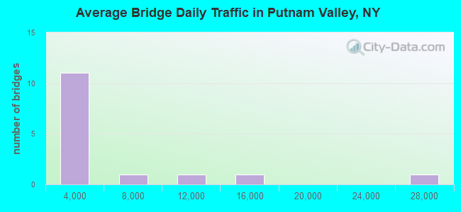
- 71,263Total average daily traffic
- 1,779Total average daily truck traffic
- National Bridge Inventory (NBI) Registered Bridges for Putnam Valley
- No street view available for this location
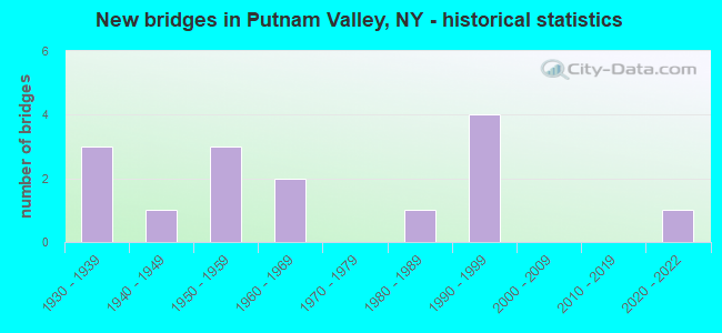
- New bridges - historical statistics
- 31930-1939
- 11940-1949
- 31950-1959
- 21960-1969
- 11980-1989
- 41990-1999
- 12020-2022
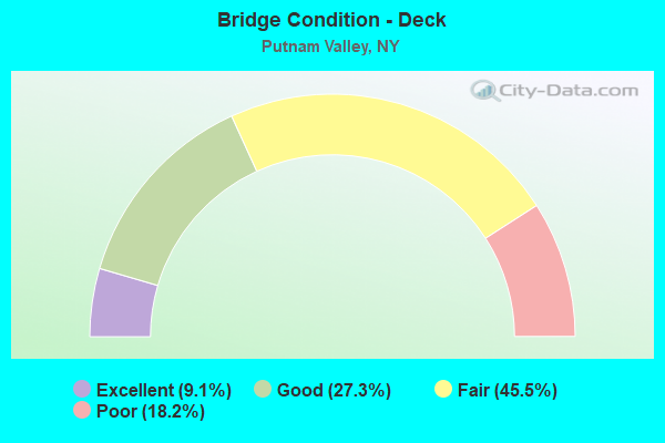
- Bridge Condition - Deck
- 9.1%Excellent
- 27.3%Good
- 45.5%Fair
- 18.2%Poor
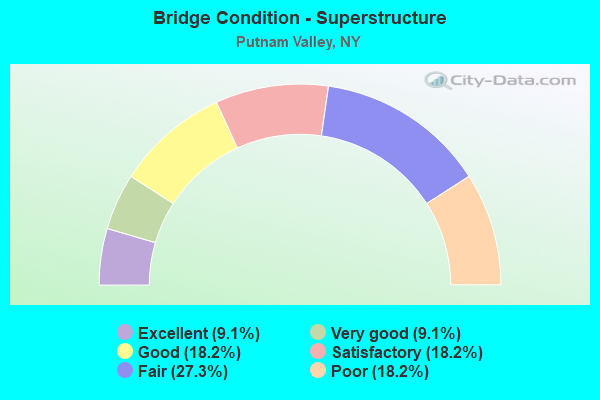
- Bridge Condition - Superstructure
- 9.1%Excellent
- 9.1%Very good
- 18.2%Good
- 18.2%Satisfactory
- 27.3%Fair
- 18.2%Poor
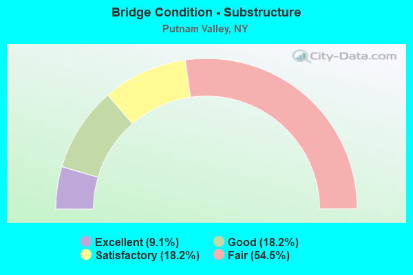
- Bridge Condition - Substructure
- 9.1%Excellent
- 18.2%Good
- 18.2%Satisfactory
- 54.5%Fair
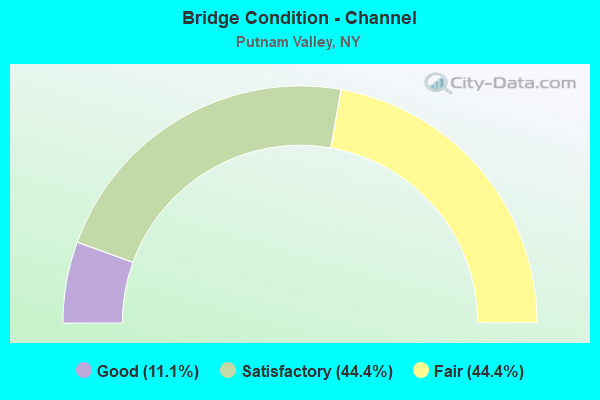
- Bridge Condition - Channel
- 11.1%Good
- 44.4%Satisfactory
- 44.4%Fair
Find on map >> Show street view
Structure Number: 108005, Location: Town of Putnam Valley (Lat: 41.428967, Lng: -73.804433), Route carried "on" structure: Other road 414, Year Built: 2020, Status: Open, Structure Length: 4.21m (13.81ft), Average Daily Traffic: 4,403 (year 2019), Truck Traffic: 10%, Average Future Daily Traffic: 4,430 (year 2040), Design Load: HL 93, Features Intersected: 987G84021071 SB, 987G840
Minimum Vertical Clearance: 32.69m (107.25ft), Kilometerpoint: 3.121, Lanes on structure: 2, Lanes under structure: 4, Owner: State Highway Agency, Approaching Roadway Width: 11.6m (38.1ft), Material/Design: Steel, Design/Construction: Stringer/Multi-beam, Number Of Spans In Main Unit: 2, Length of Maximum Span: 20.1m (65.9ft), Curb-To-Curb Width: 11.6m (38.1ft), Out-to-Out Width: 12.9m (42.3ft)
Condition: Deck: Excellent, Superstructure: Excellent, Substructure: Excellent, Operating Rating: 82.3 metric tons, Method Used To Determine Operating Rating: Load and Resistance Factor Rating (LRFR) rating reported by rating factor(RF) method using HL-93 loadings, Inventory Rating: 63.5 metric tons, Method Used To Determine Inventory Rating: Load and Resistance Factor Rating (LRFR) rating reported by rating factor(RF) method using HL-93 loadings, Structural Evaluation: Superior to present desirable criteria, Deck Geometry: Somewhat better than minimum adequacy, Underclear: Somewhat better than minimum adequacy, Approach Roadway Alignment: Equal to present desirable criteria, Length Of Structure Improvement: 4.20m (13.78ft), Designated Inspection Frequency: Every 24 months, Inspection Date: July 2021, Bridge Improvement Cost: $3,122,000, Roadway Improvement Cost: $1,828,000, Total Project Cost: $4,951,000 ( Estimate for 2021), Deck Structure Type: Concrete Cast-file-Place, Wearing Surface/Protective System: Wearing Surface: Integral Concrete, Deck Protection: Other Coated Reinforcing
Find on map >> Show street view
Structure Number: 222393, Location: 1.0MI SW OF TOMPKNSONR (Lat: 41.388592, Lng: -73.812683), Route carried "on" structure: Other road , Year Built: 1988, Status: Open, Structure Length: 0.82m (2.69ft), Average Daily Traffic: 2,332 (year 2017), Truck Traffic: 4%, Average Future Daily Traffic: 3,265 (year 2037), Design Load: HS 20, Features Intersected: PEEKSKLL HOLLW CREEK, Facility Carried by Structure: BRYANT POND ROAD
Minimum Vertical Clearance: 30+ m (98+ ft), Kilometerpoint: 2.156, Lanes on structure: 2, Owner: Town or Township Highway Agency, Approaching Roadway Width: 5.5m (18.0ft), Material/Design: Concrete, Design/Construction: Culvert, Number Of Spans In Main Unit: 1, Length of Maximum Span: 7.9m (25.9ft), Curb-To-Curb Width: 6.3m (20.7ft), Out-to-Out Width: 7.0m (23.0ft)
Condition: Channel: Fair, Culverts: Fair, Operating Rating: 59.6 metric tons, Method Used To Determine Operating Rating: Load and Resistance Factor Rating (LRFR) rating reported by rating factor(RF) method using HL-93 loadings, Inventory Rating: 46.0 metric tons, Method Used To Determine Inventory Rating: Load and Resistance Factor Rating (LRFR) rating reported by rating factor(RF) method using HL-93 loadings, Structural Evaluation: Somewhat better than minimum adequacy, Deck Geometry: High priority of replacement, Waterway Adequacy: Meets minimum limits, Approach Roadway Alignment: Meets minimum limits, Length Of Structure Improvement: 0.82m (2.69ft), Designated Inspection Frequency: Every 24 months, Inspection Date: June 2021, Bridge Improvement Cost: $428,000, Roadway Improvement Cost: $251,000, Total Project Cost: $679,000 ( Estimate for 2021)
Find on map >> Show street view
Structure Number: 222394, Location: 1.5 MI SW OF OSCAWANA LK (Lat: 41.384142, Lng: -73.873831), Route carried "on" structure: Other road , Year Built: 1999, Status: Open, Structure Length: 1.34m (4.40ft), Average Daily Traffic: 1,243 (year 2017), Truck Traffic: 3%, Average Future Daily Traffic: 1,740 (year 2037), Design Load: HS 25 or greater, Features Intersected: CANOPUS CREEK, Facility Carried by Structure: CANOPUS HOLLOW RD
Minimum Vertical Clearance: 30+ m (98+ ft), Kilometerpoint: 2.220, Lanes on structure: 2, Owner: Town or Township Highway Agency, Approaching Roadway Width: 7.9m (25.9ft), Skew: 3 degrees, Material/Design: Prestressed concrete, Design/Construction: Box Beam or Girders - Multiple, Number Of Spans In Main Unit: 1, Length of Maximum Span: 12.2m (40.0ft), Curb-To-Curb Width: 7.8m (25.6ft), Out-to-Out Width: 8.6m (28.2ft)
Condition: Deck: Good, Superstructure: Very good, Substructure: Good, Channel: Satisfactory, Operating Rating: 95.3 metric tons, Method Used To Determine Operating Rating: Load Factor (LF), Inventory Rating: 56.2 metric tons, Method Used To Determine Inventory Rating: Load Factor (LF), Structural Evaluation: Better than present minimum criteria, Deck Geometry: Meets minimum limits, Waterway Adequacy: Somewhat better than minimum adequacy, Approach Roadway Alignment: Equal to present desirable criteria, Length Of Structure Improvement: 1.34m (4.40ft), Designated Inspection Frequency: Every 24 months, Inspection Date: December 2021, Bridge Improvement Cost: $301,000, Roadway Improvement Cost: $176,000, Total Project Cost: $477,000 ( Estimate for 2021), Deck Structure Type: Concrete Cast-file-Place, Wearing Surface/Protective System: Wearing Surface: Monolithic Concrete, Deck Protection: Epoxy Coated Reinforcing
Find on map >> Show street view
Structure Number: 222398, Location: 6.1 MI NE OF PEEKSKILL (Lat: 41.368069, Lng: -73.878928), Route carried "on" structure: Other road , Year Built: 1955, Status: Open, Structure Length: 0.76m (2.49ft), Average Daily Traffic: 898 (year 2017), Truck Traffic: 3%, Average Future Daily Traffic: 1,257 (year 2037), Features Intersected: CANOPUS CREEK, Facility Carried by Structure: CIMARRON ROAD
Minimum Vertical Clearance: 30+ m (98+ ft), Kilometerpoint: 0.048, Lanes on structure: 2, Owner: Town or Township Highway Agency, Approaching Roadway Width: 5.5m (18.0ft), Material/Design: Steel, Design/Construction: Stringer/Multi-beam, Number Of Spans In Main Unit: 1, Length of Maximum Span: 7.3m (24.0ft), Curb-To-Curb Width: 5.5m (18.0ft), Out-to-Out Width: 5.8m (19.0ft)
Condition: Deck: Good, Superstructure: Satisfactory, Substructure: Fair, Channel: Fair, Operating Rating: 30.1 metric tons, Method Used To Determine Operating Rating: Load and Resistance Factor Rating (LRFR) rating reported by rating factor(RF) method using HL-93 loadings, Inventory Rating: 23.3 metric tons, Method Used To Determine Inventory Rating: Load and Resistance Factor Rating (LRFR) rating reported by rating factor(RF) method using HL-93 loadings, Structural Evaluation: Somewhat better than minimum adequacy, Deck Geometry: High priority of replacement, Waterway Adequacy: Meets minimum limits, Approach Roadway Alignment: Equal to present desirable criteria, Length Of Structure Improvement: 0.76m (2.49ft), Designated Inspection Frequency: Every 24 months, Inspection Date: April 2020, Bridge Improvement Cost: $321,000, Roadway Improvement Cost: $188,000, Total Project Cost: $509,000 ( Estimate for 2021), Deck Structure Type: Wood or Timber, Wearing Surface/Protective System: Wearing Surface: Bituminous
Find on map >> Show street view
Structure Number: 222399, Location: 1.5 MI SW OF OSCAWANA L (Lat: 41.378853, Lng: -73.872733), Route carried "on" structure: Other road , Year Built: 1930, Status: Open, Structure Length: 0.98m (3.22ft), Average Daily Traffic: 184 (year 2020), Truck Traffic: 8%, Average Future Daily Traffic: 227 (year 2040), Features Intersected: CANOPUS CREEK, Facility Carried by Structure: HORTON HOLLOW ROAD
Minimum Vertical Clearance: 30+ m (98+ ft), Kilometerpoint: 1.335, Lanes on structure: 1, Owner: Town or Township Highway Agency, Approaching Roadway Width: 3.7m (12.1ft), Material/Design: Steel, Design/Construction: Stringer/Multi-beam, Number Of Spans In Main Unit: 1, Length of Maximum Span: 8.8m (28.9ft), Curb-To-Curb Width: 4.6m (15.1ft), Out-to-Out Width: 5.2m (17.1ft)
Condition: Deck: Poor, Superstructure: Fair, Substructure: Fair, Channel: Satisfactory, Operating Rating: 28.5 metric tons, Method Used To Determine Operating Rating: Load and Resistance Factor Rating (LRFR) rating reported by rating factor(RF) method using HL-93 loadings, Inventory Rating: 22.0 metric tons, Method Used To Determine Inventory Rating: Load and Resistance Factor Rating (LRFR) rating reported by rating factor(RF) method using HL-93 loadings, Structural Evaluation: Somewhat better than minimum adequacy, Deck Geometry: High priority of replacement, Waterway Adequacy: Meets minimum limits, Approach Roadway Alignment: Better than present minimum criteria, Length Of Structure Improvement: 0.97m (3.18ft), Designated Inspection Frequency: Every 24 months, Inspection Date: May 2020, Bridge Improvement Cost: $219,000, Roadway Improvement Cost: $129,000, Total Project Cost: $348,000 ( Estimate for 2021), Deck Structure Type: Concrete Cast-file-Place, Wearing Surface/Protective System: Wearing Surface: Bituminous
Find on map >> Show street view
Structure Number: 3224, Location: 3.8 MI NE OF PEEKSKILL (Lat: 41.336950, Lng: -73.879933), Route carried "on" structure: Other road , Year Built: 1969, Status: Open, Structure Length: 3.23m (10.60ft), Average Daily Traffic: 1,309 (year 2017), Truck Traffic: 2%, Average Future Daily Traffic: 1,833 (year 2037), Design Load: HS 20, Features Intersected: LAKE PEEKS OUTLET, Facility Carried by Structure: LAKE DRIVE
Minimum Vertical Clearance: 30+ m (98+ ft), Kilometerpoint: 1.963, Lanes on structure: 2, Owner: County Highway Agency, Approaching Roadway Width: 7.3m (24.0ft), Material/Design: Prestressed concrete, Design/Construction: Stringer/Multi-beam, Number Of Spans In Main Unit: 1, Length of Maximum Span: 30.4m (99.7ft), Curb or Sidewalk Widths: Left: 1.5m (4.9ft), Right: 0.0m, Curb-To-Curb Width: 7.4m (24.3ft), Out-to-Out Width: 9.6m (31.5ft)
Condition: Deck: Fair, Superstructure: Satisfactory, Substructure: Good, Channel: Good, Operating Rating: 50.9 metric tons, Method Used To Determine Operating Rating: Load and Resistance Factor Rating (LRFR) rating reported by rating factor(RF) method using HL-93 loadings, Inventory Rating: 13.3 metric tons, Method Used To Determine Inventory Rating: Load and Resistance Factor Rating (LRFR) rating reported by rating factor(RF) method using HL-93 loadings, Structural Evaluation: Meets minimum limits, Deck Geometry: Meets minimum limits, Waterway Adequacy: Equal to present desirable criteria, Approach Roadway Alignment: Equal to present desirable criteria, Length Of Structure Improvement: 3.23m (10.60ft), Designated Inspection Frequency: Every 24 months, Inspection Date: April 2020, Bridge Improvement Cost: $829,000, Roadway Improvement Cost: $485,000, Total Project Cost: $1,314,000 ( Estimate for 2021), Deck Structure Type: Concrete Cast-file-Place, Wearing Surface/Protective System: Wearing Surface: Bituminous
Find on map >> Show street view
Structure Number: 334564, Location: 3.5 MI N OF SHRUB OAK (Lat: 41.377264, Lng: -73.828189), Route carried "on" structure: County highway , Year Built: 1940, Status: Open, Structure Length: 1.58m (5.18ft), Average Daily Traffic: 1,932 (year 2020), Truck Traffic: 7%, Average Future Daily Traffic: 2,346 (year 2040), Features Intersected: PEEKSKILL HOLLOW CREEK, Facility Carried by Structure: PEEKSKILL HOLLOW
Minimum Vertical Clearance: 30+ m (98+ ft), Kilometerpoint: 6.935, Lanes on structure: 2, Owner: County Highway Agency, Approaching Roadway Width: 6.7m (22.0ft), Skew: 4 degrees, Material/Design: Steel, Design/Construction: Stringer/Multi-beam, Number Of Spans In Main Unit: 1, Length of Maximum Span: 14.9m (48.9ft), Curb-To-Curb Width: 6.7m (22.0ft), Out-to-Out Width: 7.5m (24.6ft)
Condition: Deck: Fair, Superstructure: Fair, Substructure: Fair, Channel: Fair, Operating Rating: 27.9 metric tons, Method Used To Determine Operating Rating: Load and Resistance Factor Rating (LRFR) rating reported by rating factor(RF) method using HL-93 loadings, Inventory Rating: 21.7 metric tons, Method Used To Determine Inventory Rating: Load and Resistance Factor Rating (LRFR) rating reported by rating factor(RF) method using HL-93 loadings, Structural Evaluation: Somewhat better than minimum adequacy, Deck Geometry: High priority of corrective action, Waterway Adequacy: Meets minimum limits, Approach Roadway Alignment: Somewhat better than minimum adequacy, Length Of Structure Improvement: 1.58m (5.18ft), Designated Inspection Frequency: Every 24 months, Inspection Date: April 2020, Bridge Improvement Cost: $671,000, Roadway Improvement Cost: $393,000, Total Project Cost: $1,065,000 ( Estimate for 2021), Deck Structure Type: Concrete Cast-file-Place, Wearing Surface/Protective System: Wearing Surface: Monolithic Concrete
Find on map >> Show street view
Structure Number: 334565, Location: 2.4 MI NW OF SHRUB OAK (Lat: 41.336358, Lng: -73.865011), Route carried "on" structure: County highway , Year Built: 1959, Status: Open, Structure Length: 2.47m (8.10ft), Average Daily Traffic: 3,631 (year 2017), Truck Traffic: 2%, Average Future Daily Traffic: 4,410 (year 2040), Design Load: H 20, Features Intersected: PEEKSKILL HOLLOW CREEK, Facility Carried by Structure: PEEKSKILL HOLLOW R
Minimum Vertical Clearance: 30+ m (98+ ft), Kilometerpoint: 0.917, Lanes on structure: 2, Owner: County Highway Agency, Approaching Roadway Width: 8.5m (27.9ft), Skew: 3 degrees, Material/Design: Steel, Design/Construction: Stringer/Multi-beam, Number Of Spans In Main Unit: 1, Length of Maximum Span: 23.1m (75.8ft), Curb or Sidewalk Widths: Left: 0.6m (2.0ft), Right: 1.2m (3.9ft), Curb-To-Curb Width: 6.7m (22.0ft), Out-to-Out Width: 12.7m (41.7ft)
Condition: Deck: Fair, Superstructure: Poor, Substructure: Fair, Channel: Satisfactory, Operating Rating: 24.3 metric tons, Method Used To Determine Operating Rating: Load and Resistance Factor Rating (LRFR) rating reported by rating factor(RF) method using HL-93 loadings, Inventory Rating: 18.5 metric tons, Method Used To Determine Inventory Rating: Load and Resistance Factor Rating (LRFR) rating reported by rating factor(RF) method using HL-93 loadings, Structural Evaluation: Meets minimum limits, Deck Geometry: High priority of replacement, Waterway Adequacy: Meets minimum limits, Approach Roadway Alignment: Equal to present desirable criteria, Length Of Structure Improvement: 2.46m (8.07ft), Designated Inspection Frequency: Every 24 months, Inspection Date: May 2021, Bridge Improvement Cost: $2,576,000, Roadway Improvement Cost: $1,509,000, Total Project Cost: $4,085,000 ( Estimate for 2021), Deck Structure Type: Concrete Cast-file-Place, Wearing Surface/Protective System: Wearing Surface: Bituminous
Find on map >> Show street view
Structure Number: 334567, Location: 2.1 MI NW OF SHRUB OAK (Lat: 41.353567, Lng: -73.842075), Route carried "on" structure: County highway , Year Built: 1959, Status: Open, Structure Length: 2.01m (6.59ft), Average Daily Traffic: 1,919 (year 2020), Truck Traffic: 5%, Average Future Daily Traffic: 2,374 (year 2040), Design Load: H 20, Features Intersected: PEEKSKILL HOL CK, Facility Carried by Structure: CHURCH ROAD CR 22
Minimum Vertical Clearance: 30+ m (98+ ft), Kilometerpoint: 3.250, Lanes on structure: 2, Owner: County Highway Agency, Approaching Roadway Width: 6.1m (20.0ft), Material/Design: Steel, Design/Construction: Stringer/Multi-beam, Number Of Spans In Main Unit: 1, Length of Maximum Span: 18.5m (60.7ft), Curb or Sidewalk Widths: Left: 0.4m (1.3ft), Right: 1.2m (3.9ft), Curb-To-Curb Width: 7.9m (25.9ft), Out-to-Out Width: 10.2m (33.5ft)
Condition: Deck: Fair, Superstructure: Good, Substructure: Fair, Channel: Fair, Operating Rating: 44.4 metric tons, Method Used To Determine Operating Rating: Load and Resistance Factor Rating (LRFR) rating reported by rating factor(RF) method using HL-93 loadings, Inventory Rating: 34.0 metric tons, Method Used To Determine Inventory Rating: Load and Resistance Factor Rating (LRFR) rating reported by rating factor(RF) method using HL-93 loadings, Structural Evaluation: Somewhat better than minimum adequacy, Deck Geometry: Meets minimum limits, Waterway Adequacy: Superior to present desirable criteria, Approach Roadway Alignment: Equal to present desirable criteria, Length Of Structure Improvement: 2.01m (6.59ft), Designated Inspection Frequency: Every 24 months, Inspection Date: April 2020, Bridge Improvement Cost: $1,307,000, Roadway Improvement Cost: $765,000, Total Project Cost: $2,073,000 ( Estimate for 2021), Deck Structure Type: Concrete Cast-file-Place, Wearing Surface/Protective System: Wearing Surface: Bituminous
Find on map >> Show street view
Structure Number: 334568, Location: 2.9 MI W OF SHRUB OAK (Lat: 41.333269, Lng: -73.874989), Route carried "on" structure: County highway , Year Built: 1964, Status: Open, Structure Length: 1.86m (6.10ft), Average Daily Traffic: 8,198 (year 2017), Truck Traffic: 4%, Average Future Daily Traffic: 10,143 (year 2040), Design Load: H 20, Features Intersected: PEEKSKLL HOLLW CK, Facility Carried by Structure: OSCAWANNA LAKE RD
Minimum Vertical Clearance: 30+ m (98+ ft), Kilometerpoint: 0.000, Lanes on structure: 2, Owner: County Highway Agency, Approaching Roadway Width: 7.6m (24.9ft), Skew: 1 degrees, Material/Design: Prestressed concrete, Design/Construction: Box Beam or Girders - Multiple, Number Of Spans In Main Unit: 1, Length of Maximum Span: 17.9m (58.7ft), Curb or Sidewalk Widths: Left: 0.5m (1.6ft), Right: 1.8m (5.9ft), Curb-To-Curb Width: 8.6m (28.2ft), Out-to-Out Width: 11.1m (36.4ft)
Condition: Deck: Poor, Superstructure: Poor, Substructure: Fair, Channel: Satisfactory, Operating Rating: 48.0 metric tons, Method Used To Determine Operating Rating: Load and Resistance Factor Rating (LRFR) rating reported by rating factor(RF) method using HL-93 loadings, Inventory Rating: 19.1 metric tons, Method Used To Determine Inventory Rating: Load and Resistance Factor Rating (LRFR) rating reported by rating factor(RF) method using HL-93 loadings, Structural Evaluation: Meets minimum limits, Deck Geometry: High priority of replacement, Waterway Adequacy: Superior to present desirable criteria, Approach Roadway Alignment: Equal to present desirable criteria, Length Of Structure Improvement: 1.85m (6.07ft), Designated Inspection Frequency: Every 24 months, Inspection Date: April 2021, Bridge Improvement Cost: $762,000, Roadway Improvement Cost: $446,000, Total Project Cost: $1,208,000 ( Estimate for 2021), Wearing Surface/Protective System: Wearing Surface: Bituminous
Find on map >> Show street view
Structure Number: 336813, Location: 3 MI N JCT US 6 & TSP (Lat: 41.374703, Lng: -73.800186), Route carried "on" structure: County highway , Year Built: 1993, Status: Open, Structure Length: 5.43m (17.81ft), Average Daily Traffic: 3,172 (year 2019), Truck Traffic: 4%, Average Future Daily Traffic: 3,924 (year 2040), Design Load: HS 20, Features Intersected: 987G987G84021027 SB, R, Facility Carried by Structure: BRYANT POND ROAD
Minimum Vertical Clearance: 30+ m (98+ ft), Kilometerpoint: 0.000, Lanes on structure: 2, Lanes under structure: 5, Owner: State Highway Agency, Approaching Roadway Width: 11.6m (38.1ft), Skew: 2 degrees, Material/Design: Steel, Design/Construction: Stringer/Multi-beam, Number Of Spans In Main Unit: 1, Length of Maximum Span: 53.3m (174.9ft), Curb-To-Curb Width: 11.6m (38.1ft), Out-to-Out Width: 12.5m (41.0ft)
Condition: Deck: Good, Superstructure: Good, Substructure: Satisfactory, Operating Rating: 50.2 metric tons, Method Used To Determine Operating Rating: Load and Resistance Factor Rating (LRFR) rating reported by rating factor(RF) method using HL-93 loadings, Inventory Rating: 38.9 metric tons, Method Used To Determine Inventory Rating: Load and Resistance Factor Rating (LRFR) rating reported by rating factor(RF) method using HL-93 loadings, Structural Evaluation: Equal to present minimum criteria, Deck Geometry: Somewhat better than minimum adequacy, Underclear: Meets minimum limits, Approach Roadway Alignment: Equal to present desirable criteria, Length Of Structure Improvement: 5.42m (17.78ft), Designated Inspection Frequency: Every 24 months, Inspection Date: June 2020, Bridge Improvement Cost: $3,588,000, Roadway Improvement Cost: $2,101,000, Total Project Cost: $5,689,000 ( Estimate for 2021), Deck Structure Type: Concrete Cast-file-Place, Wearing Surface/Protective System: Wearing Surface: Integral Concrete, Deck Protection: Epoxy Coated Reinforcing
Find on map >> Show street view
Structure Number: 5502329, Location: 5.9 MI NE OF SHRUB OAK (Lat: 41.409631, Lng: -73.786764), Route carried "on" structure: State highway 987G, Year Built: 1934, Status: Open, Structure Length: 2.35m (7.71ft), Average Daily Traffic: 25,310 (year 2020), Truck Traffic: 1%, Average Future Daily Traffic: 60,716 (year 2040), Design Load: HS 20, Features Intersected: CR 21-PKLL HOL RD
Minimum Vertical Clearance: 30+ m (98+ ft), Kilometerpoint: 8.463, Lanes on structure: 4, Lanes under structure: 2, Base Highway Network: Yes, Owner: State Highway Agency, Approaching Roadway Width: 12.8m (42.0ft), Skew: 33 degrees, Material/Design: Concrete, Design/Construction: Frame, Number Of Spans In Main Unit: 1, Length of Maximum Span: 21.3m (69.9ft), Curb-To-Curb Width: 12.9m (42.3ft), Out-to-Out Width: 14.7m (48.2ft)
Condition: Deck: Fair, Superstructure: Fair, Substructure: Satisfactory, Operating Rating: 86.3 metric tons, Method Used To Determine Operating Rating: Field evaluation and documented engineering judgment, Inventory Rating: 29.4 metric tons, Method Used To Determine Inventory Rating: Field evaluation and documented engineering judgment, Structural Evaluation: Somewhat better than minimum adequacy, Deck Geometry: High priority of replacement, Underclear: Equal to present minimum criteria, Approach Roadway Alignment: Equal to present desirable criteria, Length Of Structure Improvement: 2.34m (7.68ft), Designated Inspection Frequency: Every 24 months, Inspection Date: July 2020, Bridge Improvement Cost: $2,226,000, Roadway Improvement Cost: $1,304,000, Total Project Cost: $3,530,000 ( Estimate for 2021), Wearing Surface/Protective System: Wearing Surface: Bituminous
Find on map >> Show street view
Structure Number: 336813, Location: 3 MI N JCT US 6 & TSP (Lat: 41.374703, Lng: -73.800186), Route carried "under" structure: Other road 987G, Year Built: 1993, Structure Length: 0. m, Average Daily Traffic: 13,400 (year 1990), Features Intersected: 987G987G84021027 SB, R, Facility Carried by Structure: BRYANT POND ROAD
Minimum Vertical Clearance: 4.57m (14.99ft), Kilometerpoint: 37.490, Lanes on structure: 2, Lanes under structure: 2, Material/Design: Steel, Design/Construction: Stringer/Multi-beam, Length of Maximum Span: 53.3m (174.9ft)
Find on map >> Show street view
Structure Number: 336813, Location: 3 MI N JCT US 6 & TSP (Lat: 41.374703, Lng: -73.800186), Route carried "under" structure: Other road , Year Built: 1993, Structure Length: 0. m, Average Daily Traffic: 1,400 (year 2021), Features Intersected: 987G987G84021027 SB, R, Facility Carried by Structure: BRYANT POND ROAD
Minimum Vertical Clearance: 4.47m (14.67ft), Kilometerpoint: 37.490, Lanes on structure: 2, Lanes under structure: 1, Material/Design: Steel, Design/Construction: Stringer/Multi-beam, Length of Maximum Span: 53.3m (174.9ft)
Find on map >> Show street view
Structure Number: 5502329, Location: 5.9 MI NE OF SHRUB OAK (Lat: 41.409631, Lng: -73.786764), Route carried "under" structure: County highway , Year Built: 1934, Structure Length: 0. m, Average Daily Traffic: 1,932 (year 2020), Truck Traffic: 7%, Features Intersected: CR 21-PKLL HOL RD, Facility Carried by Structure: RTE 987G
Minimum Vertical Clearance: 5.07m (16.63ft), Kilometerpoint: 6.935, Lanes on structure: 4, Lanes under structure: 2, Material/Design: Concrete, Design/Construction: Frame, Length of Maximum Span: 21.3m (69.9ft)