Bridge Statistics for Puako, Hawaii (HI)
Condition, Traffic, Stress, Structural Evaluation, Project Costs
- National Bridge Inventory (NBI) Statistics
- 14Number of bridges
- 79ft / 24.3mTotal length
- $15,985,000Total costs
- 51,960Total average daily traffic
- 3,631Total average daily truck traffic
- 56,155Total future (year 2025) average daily traffic
- National Bridge Inventory (NBI) Registered Bridges for Puako
- No street view available for this location
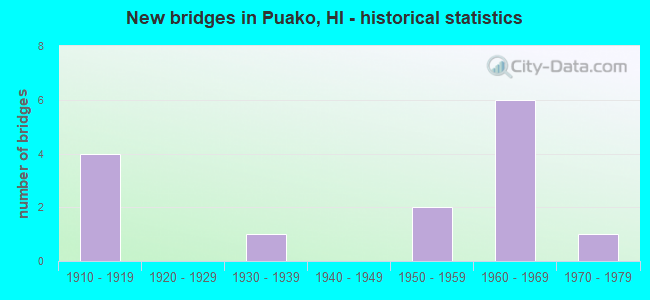
- New bridges - historical statistics
- 41910-1919
- 11930-1939
- 21950-1959
- 61960-1969
- 11970-1979


- Bridge Condition - Deck
- 80.0%Satisfactory
- 10.0%Fair
- 10.0%Poor

- Bridge Condition - Superstructure
- 10.0%Very good
- 70.0%Satisfactory
- 20.0%Fair

- Bridge Condition - Substructure
- 30.0%Good
- 60.0%Satisfactory
- 10.0%Fair

- Bridge Condition - Channel
- 35.7%Very good
- 35.7%Good
- 14.3%Satisfactory
- 14.3%Fair

- Bridge Condition - Culverts
- 50.0%Good
- 50.0%Satisfactory
Find on map >> Show street view
Structure Number: 1000270300275, Location: 0.19MI N/SPENCER PK RD (Lat: 20.031478, Lng: -155.822394), Route carried "on" structure: US 270, Year Built: 1934, Year Reconstructed: 1960, Status: Open, Structure Length: 1.80m (5.91ft), Average Daily Traffic: 7,500 (year 2017), Truck Traffic: 9%, Average Future Daily Traffic: 6,828 (year 2025), Design Load: HS 20, Features Intersected: MAKEAHUA STRM, Facility Carried by Structure: KAWAIHAE-MAHUKONA
Minimum Vertical Clearance: 30+ m (98+ ft), Kilometerpoint: 1.609, Lanes on structure: 2, Owner: State Highway Agency, Approaching Roadway Width: 11.6m (38.1ft), Skew: 4 degrees, Material/Design: Concrete continuous, Design/Construction: Tee Beam, Number Of Spans In Main Unit: 1, Length of Maximum Span: 16.5m (54.1ft), Curb or Sidewalk Widths: Left: 1.2m (3.9ft), Right: 0.6m (2.0ft), Curb-To-Curb Width: 8.5m (27.9ft), Out-to-Out Width: 11.3m (37.1ft)
Condition: Deck: Satisfactory, Superstructure: Satisfactory, Substructure: Good, Channel: Fair, Operating Rating: 21.7 metric tons, Method Used To Determine Operating Rating: Load and Resistance Factor Rating (LRFR) rating reported by rating factor(RF) method using HL-93 loadings, Inventory Rating: 16.8 metric tons, Method Used To Determine Inventory Rating: Load and Resistance Factor Rating (LRFR) rating reported by rating factor(RF) method using HL-93 loadings, Structural Evaluation: Meets minimum limits, Deck Geometry: High priority of replacement, Waterway Adequacy: Meets minimum limits, Approach Roadway Alignment: Equal to present minimum criteria, Length Of Structure Improvement: 2.51m (8.23ft), Designated Inspection Frequency: Every 24 months, Inspection Date: March 2020, Roadway Improvement Cost: $23,000, Total Project Cost: $349,000, Deck Structure Type: Concrete Cast-file-Place
Find on map >> Show street view
Structure Number: 1000270300281, Location: 0.25MI N/SPENCER PK RD (Lat: 20.033333, Lng: -155.822778), Route carried "on" structure: US 270, Year Built: 1960, Status: Open, Structure Length: 0.94m (3.08ft), Average Daily Traffic: 7,500 (year 2017), Truck Traffic: 9%, Average Future Daily Traffic: 6,828 (year 2025), Design Load: HS 20, Features Intersected: MAKAHUNA STRM, Facility Carried by Structure: KAWAIHAE-MAHUKONA
Minimum Vertical Clearance: 30+ m (98+ ft), Kilometerpoint: 1.552, Lanes on structure: 2, Owner: State Highway Agency, Approaching Roadway Width: 11.6m (38.1ft), Skew: 1 degrees, Material/Design: Concrete, Design/Construction: Slab, Number Of Spans In Main Unit: 1, Length of Maximum Span: 8.5m (27.9ft), Curb-To-Curb Width: 12.2m (40.0ft), Out-to-Out Width: 12.8m (42.0ft)
Condition: Deck: Satisfactory, Superstructure: Satisfactory, Substructure: Satisfactory, Channel: Good, Operating Rating: 43.1 metric tons, Method Used To Determine Operating Rating: Load and Resistance Factor Rating (LRFR) rating reported by rating factor(RF) method using HL-93 loadings, Inventory Rating: 33.4 metric tons, Method Used To Determine Inventory Rating: Load and Resistance Factor Rating (LRFR) rating reported by rating factor(RF) method using HL-93 loadings, Structural Evaluation: Equal to present minimum criteria, Deck Geometry: Somewhat better than minimum adequacy, Waterway Adequacy: Better than present minimum criteria, Approach Roadway Alignment: Equal to present minimum criteria, Designated Inspection Frequency: Every 24 months, Inspection Date: March 2020, Roadway Improvement Cost: $17,000, Total Project Cost: $253,000, Deck Structure Type: Concrete Cast-file-Place
Find on map >> Show street view
Structure Number: 1000270300326, Location: 0.70MI N/SPENCER PK RD (Lat: 20.037333, Lng: -155.827111), Route carried "on" structure: US 270, Year Built: 1960, Status: Open, Structure Length: 1.58m (5.18ft), Average Daily Traffic: 7,500 (year 2017), Truck Traffic: 9%, Average Future Daily Traffic: 6,828 (year 2025), Design Load: HS 20, Features Intersected: KAWAIHAE STRM, Facility Carried by Structure: KAWAIHAE-MAHUKONA
Minimum Vertical Clearance: 30+ m (98+ ft), Kilometerpoint: 2.188, Lanes on structure: 2, Owner: State Highway Agency, Approaching Roadway Width: 11.6m (38.1ft), Skew: 3 degrees, Material/Design: Concrete continuous, Design/Construction: Slab, Number Of Spans In Main Unit: 2, Length of Maximum Span: 7.6m (24.9ft), Curb-To-Curb Width: 12.2m (40.0ft), Out-to-Out Width: 12.8m (42.0ft)
Condition: Deck: Satisfactory, Superstructure: Satisfactory, Substructure: Satisfactory, Channel: Good, Operating Rating: 47.0 metric tons, Method Used To Determine Operating Rating: Load and Resistance Factor Rating (LRFR) rating reported by rating factor(RF) method using HL-93 loadings, Inventory Rating: 36.3 metric tons, Method Used To Determine Inventory Rating: Load and Resistance Factor Rating (LRFR) rating reported by rating factor(RF) method using HL-93 loadings, Structural Evaluation: Equal to present minimum criteria, Deck Geometry: Somewhat better than minimum adequacy, Waterway Adequacy: Better than present minimum criteria, Approach Roadway Alignment: Equal to present minimum criteria, Designated Inspection Frequency: Every 24 months, Inspection Date: March 2020, Roadway Improvement Cost: $24,000, Total Project Cost: $356,000, Deck Structure Type: Concrete Cast-file-Place
Find on map >> Show street view
Structure Number: 1002700500114, Location: 0.19MI N/MALUOKALANI ST (Lat: 20.051583, Lng: -155.839497), Route carried "on" structure: Spur US 270, Year Built: 1965, Status: Open, Structure Length: 4.97m (16.31ft), Average Daily Traffic: 7,500 (year 2017), Truck Traffic: 9%, Average Future Daily Traffic: 5,473 (year 2025), Design Load: HS 20, Features Intersected: HONOKOA STRM, Facility Carried by Structure: KAWAIHAE-MAHUKONA
Minimum Vertical Clearance: 30+ m (98+ ft), Kilometerpoint: 1.835, Lanes on structure: 2, Base Highway Network: Yes, Owner: State Highway Agency, Approaching Roadway Width: 10.4m (34.1ft), Material/Design: Prestressed concrete, Design/Construction: Stringer/Multi-beam, Number Of Spans In Main Unit: 2, Length of Maximum Span: 24.4m (80.1ft), Curb or Sidewalk Widths: Left: 0.6m (2.0ft), Right: 0.9m (3.0ft), Curb-To-Curb Width: 8.5m (27.9ft), Out-to-Out Width: 10.7m (35.1ft)
Condition: Deck: Satisfactory, Superstructure: Very good, Substructure: Satisfactory, Channel: Very good, Operating Rating: 89.7 metric tons, Method Used To Determine Operating Rating: Load and Resistance Factor Rating (LRFR) rating reported by rating factor(RF) method using HL-93 loadings, Inventory Rating: 62.2 metric tons, Method Used To Determine Inventory Rating: Load and Resistance Factor Rating (LRFR) rating reported by rating factor(RF) method using HL-93 loadings, Structural Evaluation: Equal to present minimum criteria, Deck Geometry: High priority of replacement, Waterway Adequacy: Better than present minimum criteria, Approach Roadway Alignment: Somewhat better than minimum adequacy, Designated Inspection Frequency: Every 24 months, Inspection Date: March 2020, Roadway Improvement Cost: $53,000, Total Project Cost: $788,000, Deck Structure Type: Concrete Cast-file-Place
Find on map >> Show street view
Structure Number: 1002700500304, Location: 2.09MI N/MALUOKALANI ST (Lat: 20.073967, Lng: -155.856081), Route carried "on" structure: Spur US 270, Year Built: 1966, Status: Open, Structure Length: 0.70m (2.30ft), Average Daily Traffic: 3,100 (year 2017), Truck Traffic: 6%, Average Future Daily Traffic: 5,473 (year 2025), Design Load: HS 20, Features Intersected: UNMD STRM-TWN MTL CULV'T, Facility Carried by Structure: KAWAIHAE-MAHUKONA
Minimum Vertical Clearance: 30+ m (98+ ft), Kilometerpoint: 4.812, Lanes on structure: 2, Base Highway Network: Yes, Owner: State Highway Agency, Approaching Roadway Width: 12.2m (40.0ft), Material/Design: Steel, Design/Construction: Culvert, Number Of Spans In Main Unit: 2, Length of Maximum Span: 3.0m (9.8ft), Curb-To-Curb Width: 31.3m (102.7ft), Out-to-Out Width: 31.3m (102.7ft)
Condition: Channel: Good, Culverts: Good, Operating Rating: 45.4 metric tons, Method Used To Determine Operating Rating: Allowable Stress (AS), Inventory Rating: 29.0 metric tons, Method Used To Determine Inventory Rating: Allowable Stress (AS), Structural Evaluation: Better than present minimum criteria, Deck Geometry: Superior to present desirable criteria, Waterway Adequacy: Better than present minimum criteria, Approach Roadway Alignment: Somewhat better than minimum adequacy, Designated Inspection Frequency: Every 24 months, Inspection Date: March 2020, Roadway Improvement Cost: $34,000, Total Project Cost: $515,000
Find on map >> Show street view
Structure Number: 1002700500655, Location: 5.60MI N/MALUOKALANI ST (Lat: 20.119147, Lng: -155.879756), Route carried "on" structure: Spur US 270, Year Built: 1966, Status: Open, Structure Length: 1.04m (3.41ft), Average Daily Traffic: 3,100 (year 2017), Truck Traffic: 6%, Average Future Daily Traffic: 5,473 (year 2025), Design Load: HS 20, Features Intersected: UNMD STRM-TPL MTL CULV'T, Facility Carried by Structure: KAWAIHAE-MAHUKONA
Minimum Vertical Clearance: 30+ m (98+ ft), Kilometerpoint: 10.460, Lanes on structure: 2, Base Highway Network: Yes, Owner: State Highway Agency, Approaching Roadway Width: 12.2m (40.0ft), Material/Design: Steel, Design/Construction: Culvert, Number Of Spans In Main Unit: 3, Length of Maximum Span: 2.7m (8.9ft), Curb-To-Curb Width: 16.9m (55.4ft), Out-to-Out Width: 17.2m (56.4ft)
Condition: Channel: Very good, Culverts: Good, Operating Rating: 45.4 metric tons, Method Used To Determine Operating Rating: Allowable Stress (AS), Inventory Rating: 29.0 metric tons, Method Used To Determine Inventory Rating: Allowable Stress (AS), Structural Evaluation: Better than present minimum criteria, Deck Geometry: Superior to present desirable criteria, Waterway Adequacy: Better than present minimum criteria, Approach Roadway Alignment: Somewhat better than minimum adequacy, Designated Inspection Frequency: Every 24 months, Inspection Date: March 2020, Total Project Cost: $702,000
Find on map >> Show street view
Structure Number: 1002700500915, Location: 8.17MI N/MALUOKALANI ST (Lat: 20.155169, Lng: -155.891708), Route carried "on" structure: Spur US 270, Year Built: 1966, Status: Open, Structure Length: 0.88m (2.89ft), Average Daily Traffic: 3,100 (year 2017), Truck Traffic: 6%, Average Future Daily Traffic: 5,473 (year 2025), Design Load: HS 20, Features Intersected: UNMD STRM-DBL MTL CULV'T, Facility Carried by Structure: KAWAIHAE-MAHUKONA
Minimum Vertical Clearance: 30+ m (98+ ft), Kilometerpoint: 14.725, Lanes on structure: 2, Base Highway Network: Yes, Owner: State Highway Agency, Approaching Roadway Width: 12.2m (40.0ft), Material/Design: Steel, Design/Construction: Culvert, Number Of Spans In Main Unit: 2, Length of Maximum Span: 4.0m (13.1ft)
Condition: Channel: Very good, Culverts: Satisfactory, Operating Rating: 47.2 metric tons, Method Used To Determine Operating Rating: Allowable Stress (AS), Inventory Rating: 29.0 metric tons, Method Used To Determine Inventory Rating: Allowable Stress (AS), Structural Evaluation: Equal to present minimum criteria, Waterway Adequacy: Equal to present minimum criteria, Approach Roadway Alignment: Equal to present desirable criteria, Designated Inspection Frequency: Every 24 months, Inspection Date: March 2020, Total Project Cost: $599,000
Find on map >> Show street view
Structure Number: 1002700501199, Location: 11 02MI N/MALUOKALANI ST (Lat: 20.195044, Lng: -155.894728), Route carried "on" structure: Spur US 270, Year Built: 1972, Status: Open, Structure Length: 0.79m (2.59ft), Average Daily Traffic: 3,100 (year 2017), Truck Traffic: 6%, Average Future Daily Traffic: 5,473 (year 2025), Design Load: HS 20, Features Intersected: UNMD STRM-MTL CULVT, Facility Carried by Structure: KAWAIHAE-MAHUKONA
Minimum Vertical Clearance: 30+ m (98+ ft), Kilometerpoint: 19.231, Lanes on structure: 2, Base Highway Network: Yes, Owner: State Highway Agency, Approaching Roadway Width: 13.4m (44.0ft), Skew: 1 degrees, Material/Design: Steel, Design/Construction: Culvert, Number Of Spans In Main Unit: 2, Length of Maximum Span: 3.4m (11.2ft), Curb-To-Curb Width: 13.4m (44.0ft), Out-to-Out Width: 25.6m (84.0ft)
Condition: Channel: Very good, Culverts: Satisfactory, Operating Rating: 51.7 metric tons, Method Used To Determine Operating Rating: Allowable Stress (AS), Inventory Rating: 30.8 metric tons, Method Used To Determine Inventory Rating: Allowable Stress (AS), Structural Evaluation: Equal to present minimum criteria, Deck Geometry: Better than present minimum criteria, Waterway Adequacy: Equal to present desirable criteria, Approach Roadway Alignment: Equal to present desirable criteria, Designated Inspection Frequency: Every 24 months, Inspection Date: March 2020
Find on map >> Show street view
Structure Number: 1002700502266, Location: 1.56MI E/KOHALA MILL RD (Lat: 20.222997, Lng: -155.761069), Route carried "on" structure: US 270, Year Built: 1919, Status: Open, Structure Length: 4.88m (16.01ft), Average Daily Traffic: 1,200 (year 2017), Truck Traffic: 2%, Average Future Daily Traffic: 2,014 (year 2025), Features Intersected: WALAOHIA GULCH, Facility Carried by Structure: KAWAIHAE-MAHUKONA
Minimum Vertical Clearance: 30+ m (98+ ft), Kilometerpoint: 36.467, Lanes on structure: 2, Owner: State Highway Agency, Approaching Roadway Width: 8.8m (28.9ft), Material/Design: Concrete continuous, Design/Construction: Tee Beam, Number Of Spans In Main Unit: 4, Length of Maximum Span: 12.2m (40.0ft), Curb-To-Curb Width: 5.5m (18.0ft), Out-to-Out Width: 6.2m (20.3ft)
Condition: Deck: Satisfactory, Superstructure: Fair, Substructure: Fair, Channel: Very good, Operating Rating: 35.3 metric tons, Method Used To Determine Operating Rating: Load and Resistance Factor Rating (LRFR) rating reported by rating factor(RF) method using HL-93 loadings, Inventory Rating: 27.2 metric tons, Method Used To Determine Inventory Rating: Load and Resistance Factor Rating (LRFR) rating reported by rating factor(RF) method using HL-93 loadings, Structural Evaluation: Somewhat better than minimum adequacy, Deck Geometry: High priority of replacement, Waterway Adequacy: Equal to present desirable criteria, Approach Roadway Alignment: Meets minimum limits, Length Of Structure Improvement: 5.85m (19.19ft), Designated Inspection Frequency: Every 24 months, Inspection Date: March 2020, Total Project Cost: $6,173,000, Deck Structure Type: Concrete Cast-file-Place
Find on map >> Show street view
Structure Number: 1002700502318, Location: 2.08MI E/KOHALA MILL RD (Lat: 20.219153, Lng: -155.755372), Route carried "on" structure: US 270, Year Built: 1918, Status: Open, Structure Length: 2.44m (8.01ft), Average Daily Traffic: 1,200 (year 2017), Truck Traffic: 2%, Average Future Daily Traffic: 2,014 (year 2025), Features Intersected: AAMAKOA GULCH, Facility Carried by Structure: KAWAIHAE-MAHUKONA
Minimum Vertical Clearance: 30+ m (98+ ft), Kilometerpoint: 37.320, Lanes on structure: 2, Owner: State Highway Agency, Approaching Roadway Width: 7.6m (24.9ft), Material/Design: Concrete continuous, Design/Construction: Tee Beam, Number Of Spans In Main Unit: 2, Length of Maximum Span: 11.9m (39.0ft), Curb-To-Curb Width: 5.5m (18.0ft), Out-to-Out Width: 6.2m (20.3ft)
Condition: Deck: Satisfactory, Superstructure: Satisfactory, Substructure: Satisfactory, Channel: Satisfactory, Operating Rating: 35.3 metric tons, Method Used To Determine Operating Rating: Load and Resistance Factor Rating (LRFR) rating reported by rating factor(RF) method using HL-93 loadings, Inventory Rating: 27.2 metric tons, Method Used To Determine Inventory Rating: Load and Resistance Factor Rating (LRFR) rating reported by rating factor(RF) method using HL-93 loadings, Structural Evaluation: Equal to present minimum criteria, Deck Geometry: High priority of replacement, Waterway Adequacy: Equal to present desirable criteria, Approach Roadway Alignment: Meets minimum limits, Length Of Structure Improvement: 3.20m (10.50ft), Designated Inspection Frequency: Every 24 months, Inspection Date: March 2020, Total Project Cost: $3,376,000, Deck Structure Type: Concrete Cast-file-Place
Find on map >> Show street view
Structure Number: 1002700502386, Location: 0.19MI E/CAMP KOAPAKA RD (Lat: 20.220333, Lng: -155.748278), Route carried "on" structure: US 270, Year Built: 1918, Status: Open, Structure Length: 0.67m (2.20ft), Average Daily Traffic: 5,760 (year 2007), Truck Traffic: 2%, Average Future Daily Traffic: 2,014 (year 2025), Features Intersected: WAIKANE STRM, Facility Carried by Structure: KAWAIHAE-MAHUKONA
Minimum Vertical Clearance: 30+ m (98+ ft), Kilometerpoint: 43.829, Lanes on structure: 2, Owner: State Highway Agency, Approaching Roadway Width: 7.0m (23.0ft), Material/Design: Concrete, Design/Construction: Tee Beam, Number Of Spans In Main Unit: 1, Length of Maximum Span: 6.1m (20.0ft), Curb or Sidewalk Widths: Left: 0.0m, Right: 1.6m (5.2ft), Curb-To-Curb Width: 5.5m (18.0ft), Out-to-Out Width: 7.8m (25.6ft)
Condition: Deck: Satisfactory, Superstructure: Satisfactory, Substructure: Satisfactory, Channel: Fair, Operating Rating: 49.6 metric tons, Method Used To Determine Operating Rating: Load and Resistance Factor Rating (LRFR) rating reported by rating factor(RF) method using HL-93 loadings, Inventory Rating: 38.2 metric tons, Method Used To Determine Inventory Rating: Load and Resistance Factor Rating (LRFR) rating reported by rating factor(RF) method using HL-93 loadings, Structural Evaluation: Equal to present minimum criteria, Deck Geometry: High priority of replacement, Waterway Adequacy: Better than present minimum criteria, Approach Roadway Alignment: High priority of corrective action, Designated Inspection Frequency: Every 24 months, Inspection Date: March 2020, Total Project Cost: $319,000, Deck Structure Type: Concrete Cast-file-Place, Wearing Surface/Protective System: Wearing Surface: Bituminous
Find on map >> Show street view
Structure Number: 100270050239, Location: 0.03MI W/NIULII RD (Lat: 20.220300, Lng: -155.747633), Route carried "on" structure: US 270, Year Built: 1918, Status: Open, Structure Length: 1.01m (3.31ft), Average Daily Traffic: 1,200 (year 2017), Truck Traffic: 2%, Average Future Daily Traffic: 2,014 (year 2025), Features Intersected: NIULII STRM, Facility Carried by Structure: KAWAIHAE-MAHUKONA
Minimum Vertical Clearance: 30+ m (98+ ft), Kilometerpoint: 38.462, Lanes on structure: 2, Owner: State Highway Agency, Approaching Roadway Width: 7.0m (23.0ft), Material/Design: Concrete, Design/Construction: Tee Beam, Number Of Spans In Main Unit: 1, Length of Maximum Span: 9.1m (29.9ft), Curb or Sidewalk Widths: Left: 1.5m (4.9ft), Right: 0.0m, Curb-To-Curb Width: 5.5m (18.0ft), Out-to-Out Width: 7.7m (25.3ft)
Condition: Deck: Satisfactory, Superstructure: Satisfactory, Substructure: Satisfactory, Channel: Satisfactory, Operating Rating: 46.3 metric tons, Method Used To Determine Operating Rating: Load and Resistance Factor Rating (LRFR) rating reported by rating factor(RF) method using HL-93 loadings, Inventory Rating: 35.6 metric tons, Method Used To Determine Inventory Rating: Load and Resistance Factor Rating (LRFR) rating reported by rating factor(RF) method using HL-93 loadings, Structural Evaluation: Equal to present minimum criteria, Deck Geometry: High priority of replacement, Waterway Adequacy: Equal to present minimum criteria, Approach Roadway Alignment: High priority of corrective action, Length Of Structure Improvement: 1.65m (5.41ft), Designated Inspection Frequency: Every 24 months, Inspection Date: March 2020, Total Project Cost: $2,083,000, Deck Structure Type: Concrete Cast-file-Place, Wearing Surface/Protective System: Wearing Surface: Bituminous
Find on map >> Show street view
Structure Number: 1620001100001, Location: TMK 6-2-02:5 (Lat: 20.012364, Lng: -155.821942), Route carried "on" structure: Other road 62000, Year Built: 1951, Status: Posted for load, Structure Length: 1.28m (4.20ft), Average Daily Traffic: 100 (year 1981), Average Future Daily Traffic: 125 (year 2025), Features Intersected: WAIULAULA GLH, Facility Carried by Structure: OLD PUAKO RD
Minimum Vertical Clearance: 30+ m (98+ ft), Kilometerpoint: 0.000, Lanes on structure: 1, Owner: County Highway Agency, Approaching Roadway Width: 4.6m (15.1ft), Material/Design: Steel, Design/Construction: Stringer/Multi-beam, Number Of Spans In Main Unit: 1, Length of Maximum Span: 11.3m (37.1ft), Curb-To-Curb Width: 5.8m (19.0ft), Out-to-Out Width: 5.8m (19.0ft)
Condition: Deck: Poor, Superstructure: Fair, Substructure: Good, Channel: Good, Operating Rating: 23.7 metric tons, Method Used To Determine Operating Rating: Load and Resistance Factor Rating (LRFR) rating reported by rating factor(RF) method using HL-93 loadings, Inventory Rating: 18.5 metric tons, Method Used To Determine Inventory Rating: Load and Resistance Factor Rating (LRFR) rating reported by rating factor(RF) method using HL-93 loadings, Structural Evaluation: Somewhat better than minimum adequacy, Deck Geometry: Meets minimum limits, Waterway Adequacy: Better than present minimum criteria, Approach Roadway Alignment: Equal to present minimum criteria, Bridge Posting: Required (Relationship of Operating Rating to Maximum Legal Load: 20.0 - 29.9% below), Length Of Structure Improvement: 1.95m (6.40ft), Designated Inspection Frequency: Every 24 months, Inspection Date: Febuary 2020, Roadway Improvement Cost: $16,000, Total Project Cost: $236,000, Deck Structure Type: Wood or Timber, Wearing Surface/Protective System: Deck Protection: Other
Find on map >> Show street view
Structure Number: 1620001100002, Location: TMK 6-2-02:6 (Lat: 20.013828, Lng: -155.821181), Route carried "on" structure: Other road 62000, Year Built: 1951, Status: Posted for load, Structure Length: 1.28m (4.20ft), Average Daily Traffic: 100 (year 1981), Average Future Daily Traffic: 125 (year 2025), Features Intersected: WAIULAULA GLH, Facility Carried by Structure: OLD PUAKO RD
Minimum Vertical Clearance: 30+ m (98+ ft), Kilometerpoint: 0.000, Lanes on structure: 1, Owner: County Highway Agency, Approaching Roadway Width: 5.5m (18.0ft), Material/Design: Steel, Design/Construction: Girder and Floorbeam System, Number Of Spans In Main Unit: 1, Length of Maximum Span: 11.3m (37.1ft), Curb-To-Curb Width: 6.1m (20.0ft), Out-to-Out Width: 6.1m (20.0ft)
Condition: Deck: Fair, Superstructure: Satisfactory, Substructure: Good, Channel: Good, Operating Rating: 23.7 metric tons, Method Used To Determine Operating Rating: Load and Resistance Factor Rating (LRFR) rating reported by rating factor(RF) method using HL-93 loadings, Inventory Rating: 18.5 metric tons, Method Used To Determine Inventory Rating: Load and Resistance Factor Rating (LRFR) rating reported by rating factor(RF) method using HL-93 loadings, Structural Evaluation: Somewhat better than minimum adequacy, Deck Geometry: Somewhat better than minimum adequacy, Waterway Adequacy: Better than present minimum criteria, Approach Roadway Alignment: Better than present minimum criteria, Bridge Posting: Required (Relationship of Operating Rating to Maximum Legal Load: 20.0 - 29.9% below), Length Of Structure Improvement: 1.95m (6.40ft), Designated Inspection Frequency: Every 24 months, Inspection Date: Febuary 2020, Roadway Improvement Cost: $16,000, Total Project Cost: $236,000, Deck Structure Type: Wood or Timber