Bridge Statistics for Provencal, Louisiana (LA)
Condition, Traffic, Stress, Structural Evaluation, Project Costs
- National Bridge Inventory (NBI) Statistics
- 14Number of bridges
- 141ft / 43.4mTotal length
- $677,000Total costs
- 15,182Total average daily traffic
- 1,917Total average daily truck traffic
- 10,709Total future (year 2036) average daily traffic
- National Bridge Inventory (NBI) Registered Bridges for Provencal
- No street view available for this location
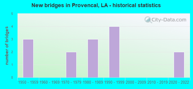
- New bridges - historical statistics
- 31950-1959
- 21970-1979
- 31980-1989
- 41990-1999
- 22020-2022

- Bridge Condition - Deck
- 15.4%Excellent
- 38.5%Good
- 46.2%Satisfactory

- Bridge Condition - Superstructure
- 7.7%Excellent
- 7.7%Very good
- 38.5%Good
- 23.1%Satisfactory
- 7.7%Fair
- 7.7%Poor
- 7.7%Serious

- Bridge Condition - Substructure
- 15.4%Excellent
- 23.1%Very good
- 23.1%Satisfactory
- 15.4%Fair
- 23.1%Poor

- Bridge Condition - Channel
- 15.4%Excellent
- 15.4%Good
- 69.2%Satisfactory
Find on map >> Show street view
Structure Number: 83500000080646, Location: 1.77 MI E of 117 (Lat: 31.643500, Lng: -93.174200), Route carried "on" structure: State highway 120, Year Built: 2020, Status: Open, Structure Length: 3.66m (12.01ft), Average Daily Traffic: 952 (year 2020), Truck Traffic: 15%, Average Future Daily Traffic: 525 (year 2037), Design Load: Greater than HL93, Features Intersected: Bayou Provencal
Minimum Vertical Clearance: 30+ m (98+ ft), Kilometerpoint: 2.852, Lanes on structure: 2, Owner: State Highway Agency, Approaching Roadway Width: 6.1m (20.0ft), Material/Design: Concrete, Design/Construction: Slab, Number Of Spans In Main Unit: 6, Length of Maximum Span: 6.1m (20.0ft), Curb-To-Curb Width: 9.1m (29.9ft), Out-to-Out Width: 9.9m (32.5ft)
Condition: Deck: Good, Superstructure: Good, Substructure: Excellent, Channel: Excellent, Operating Rating: 59.9 metric tons, Method Used To Determine Operating Rating: Load and Resistance Factor Rating (LRFR) rating reported by rating factor(RF) method using HL-93 loadings, Inventory Rating: 46.0 metric tons, Method Used To Determine Inventory Rating: Load and Resistance Factor Rating (LRFR) rating reported by rating factor(RF) method using HL-93 loadings, Structural Evaluation: Better than present minimum criteria, Deck Geometry: Equal to present minimum criteria, Waterway Adequacy: Better than present minimum criteria, Approach Roadway Alignment: Superior to present desirable criteria, Designated Inspection Frequency: Every 24 months, Inspection Date: November 2021, Deck Structure Type: Concrete Cast-file-Place
Find on map >> Show street view
Structure Number: 83500000083508, Location: 3.10 M W of LA 117 (Lat: 31.648631, Lng: -93.249661), Route carried "on" structure: County highway , Year Built: 2020, Status: Open, Structure Length: 2.50m (8.20ft), Average Daily Traffic: 80 (year 2018), Average Future Daily Traffic: 100 (year 2036), Design Load: Greater than HL93, Features Intersected: Coal Kiln Creek, Facility Carried by Structure: Robeline-Prov. Rd.
Minimum Vertical Clearance: 30+ m (98+ ft), Kilometerpoint: 6.455, Lanes on structure: 2, Owner: County Highway Agency, Approaching Roadway Width: 6.1m (20.0ft), Material/Design: Concrete, Design/Construction: Slab, Number Of Spans In Main Unit: 4, Length of Maximum Span: 6.1m (20.0ft), Curb-To-Curb Width: 7.1m (23.3ft), Out-to-Out Width: 8.1m (26.6ft)
Condition: Deck: Excellent, Superstructure: Excellent, Substructure: Excellent, Channel: Excellent, Operating Rating: 56.4 metric tons, Method Used To Determine Operating Rating: Load and Resistance Factor Rating (LRFR) rating reported by rating factor(RF) method using HL-93 loadings, Inventory Rating: 43.4 metric tons, Method Used To Determine Inventory Rating: Load and Resistance Factor Rating (LRFR) rating reported by rating factor(RF) method using HL-93 loadings, Structural Evaluation: Superior to present desirable criteria, Deck Geometry: Somewhat better than minimum adequacy, Waterway Adequacy: Better than present minimum criteria, Approach Roadway Alignment: Equal to present minimum criteria, Designated Inspection Frequency: Every 24 months, Inspection Date: January 2021, Deck Structure Type: Concrete Cast-file-Place
Find on map >> Show street view
Structure Number: 83501120604801, Location: I-49 /LA 174 INTERCHANGE (Lat: 31.885131, Lng: -93.369600), Route carried "on" structure: State highway 174, Year Built: 1985, Status: Open, Structure Length: 14.08m (46.19ft), Average Daily Traffic: 1,110 (year 2016), Truck Traffic: 14%, Average Future Daily Traffic: 914 (year 2036), Design Load: HS 20, Features Intersected: I-49
Minimum Vertical Clearance: 30+ m (98+ ft), Kilometerpoint: 8.634, Lanes on structure: 2, Lanes under structure: 4, Owner: State Highway Agency, Approaching Roadway Width: 7.9m (25.9ft), Skew: 36 degrees, Material/Design: Prestressed concrete continuous, Design/Construction: Stringer/Multi-beam, Number Of Spans In Main Unit: 3, Number Of Approach Spans: 2, Length of Maximum Span: 30.8m (101.0ft), Curb-To-Curb Width: 20.1m (65.9ft), Out-to-Out Width: 20.9m (68.6ft)
Condition: Deck: Good, Superstructure: Good, Substructure: Very good, Operating Rating: 50.8 metric tons, Method Used To Determine Operating Rating: Load Factor (LF), Inventory Rating: 30.8 metric tons, Method Used To Determine Inventory Rating: Load Factor (LF), Structural Evaluation: Better than present minimum criteria, Deck Geometry: Superior to present desirable criteria, Underclear: Better than present minimum criteria, Approach Roadway Alignment: Equal to present desirable criteria, Designated Inspection Frequency: Every 24 months, Inspection Date: Febuary 2020, Deck Structure Type: Concrete Cast-file-Place, Wearing Surface/Protective System: Wearing Surface: Monolithic Concrete
Find on map >> Show street view
Structure Number: 83501140305541, Location: 3.03 MI. NORTH OF LA 478 (Lat: 31.601831, Lng: -93.201000), Route carried "on" structure: State highway 117, Year Built: 1955, Status: Open, Structure Length: 2.44m (8.01ft), Average Daily Traffic: 1,860 (year 2016), Truck Traffic: 14%, Average Future Daily Traffic: 1,267 (year 2036), Design Load: H 15, Features Intersected: HORSE PEN CREEK
Minimum Vertical Clearance: 30+ m (98+ ft), Kilometerpoint: 8.752, Lanes on structure: 2, Owner: State Highway Agency, Approaching Roadway Width: 9.4m (30.8ft), Skew: 30 degrees, Material/Design: Concrete, Design/Construction: Slab, Number Of Spans In Main Unit: 4, Length of Maximum Span: 6.1m (20.0ft), Curb-To-Curb Width: 7.3m (24.0ft), Out-to-Out Width: 8.2m (26.9ft)
Condition: Deck: Satisfactory, Superstructure: Satisfactory, Substructure: Satisfactory, Channel: Satisfactory, Operating Rating: 32.7 metric tons, Method Used To Determine Operating Rating: Load Factor (LF), Inventory Rating: 19.0 metric tons, Method Used To Determine Inventory Rating: Load Factor (LF), Structural Evaluation: Somewhat better than minimum adequacy, Deck Geometry: Meets minimum limits, Waterway Adequacy: Equal to present minimum criteria, Approach Roadway Alignment: Equal to present desirable criteria, Designated Inspection Frequency: Every 24 months, Inspection Date: April 2020, Deck Structure Type: Concrete Cast-file-Place, Wearing Surface/Protective System: Wearing Surface: Bituminous
Find on map >> Show street view
Structure Number: 83501140308691, Location: 0.51 MI. SOUTH OF LA 120 (Lat: 31.644661, Lng: -93.201000), Route carried "on" structure: State highway 117, Year Built: 1955, Status: Open, Structure Length: 3.66m (12.01ft), Average Daily Traffic: 1,860 (year 2016), Truck Traffic: 14%, Average Future Daily Traffic: 1,267 (year 2036), Design Load: H 15, Features Intersected: FLAT SLOUGH
Minimum Vertical Clearance: 30+ m (98+ ft), Kilometerpoint: 13.752, Lanes on structure: 2, Owner: State Highway Agency, Approaching Roadway Width: 10.4m (34.1ft), Skew: 30 degrees, Material/Design: Concrete, Design/Construction: Slab, Number Of Spans In Main Unit: 6, Length of Maximum Span: 6.1m (20.0ft), Curb-To-Curb Width: 7.3m (24.0ft), Out-to-Out Width: 8.2m (26.9ft)
Condition: Deck: Satisfactory, Superstructure: Satisfactory, Substructure: Satisfactory, Channel: Satisfactory, Operating Rating: 24.9 metric tons, Method Used To Determine Operating Rating: Load and Resistance Factor Rating (LRFR) rating reported by rating factor(RF) method using HL-93 loadings, Inventory Rating: 19.1 metric tons, Method Used To Determine Inventory Rating: Load and Resistance Factor Rating (LRFR) rating reported by rating factor(RF) method using HL-93 loadings, Structural Evaluation: Somewhat better than minimum adequacy, Deck Geometry: Meets minimum limits, Waterway Adequacy: Somewhat better than minimum adequacy, Approach Roadway Alignment: Equal to present desirable criteria, Designated Inspection Frequency: Every 24 months, Inspection Date: April 2020, Deck Structure Type: Concrete Cast-file-Place, Wearing Surface/Protective System: Wearing Surface: Bituminous
Find on map >> Show street view
Structure Number: 83501140308811, Location: 0.39 MI. SOUTH OF LA 120 (Lat: 31.646369, Lng: -93.201500), Route carried "on" structure: State highway 117, Year Built: 1955, Status: Open, Structure Length: 4.27m (14.01ft), Average Daily Traffic: 1,860 (year 2016), Truck Traffic: 14%, Average Future Daily Traffic: 1,267 (year 2036), Design Load: H 15, Features Intersected: PROVENCAL BAYOU
Minimum Vertical Clearance: 30+ m (98+ ft), Kilometerpoint: 13.945, Lanes on structure: 2, Owner: State Highway Agency, Approaching Roadway Width: 9.4m (30.8ft), Skew: 30 degrees, Material/Design: Concrete, Design/Construction: Slab, Number Of Spans In Main Unit: 7, Length of Maximum Span: 6.1m (20.0ft), Curb-To-Curb Width: 7.3m (24.0ft), Out-to-Out Width: 8.2m (26.9ft)
Condition: Deck: Satisfactory, Superstructure: Satisfactory, Substructure: Satisfactory, Channel: Satisfactory, Operating Rating: 24.9 metric tons, Method Used To Determine Operating Rating: Load and Resistance Factor Rating (LRFR) rating reported by rating factor(RF) method using HL-93 loadings, Inventory Rating: 19.1 metric tons, Method Used To Determine Inventory Rating: Load and Resistance Factor Rating (LRFR) rating reported by rating factor(RF) method using HL-93 loadings, Structural Evaluation: Somewhat better than minimum adequacy, Deck Geometry: Meets minimum limits, Waterway Adequacy: Somewhat better than minimum adequacy, Approach Roadway Alignment: Equal to present desirable criteria, Designated Inspection Frequency: Every 24 months, Inspection Date: April 2020, Deck Structure Type: Concrete Cast-file-Place, Wearing Surface/Protective System: Wearing Surface: Bituminous
Find on map >> Show street view
Structure Number: 83501140313241, Location: 0.58 MI. SOUTH OF LA 6 (Lat: 31.706089, Lng: -93.216631), Route carried "on" structure: State highway 117, Year Built: 1977, Year Reconstructed: 1991, Status: Open, Structure Length: 1.77m (5.81ft), Average Daily Traffic: 3,000 (year 2016), Truck Traffic: 14%, Average Future Daily Traffic: 2,160 (year 2036), Design Load: HS 20, Features Intersected: ST. JOHNS CREEK
Minimum Vertical Clearance: 30+ m (98+ ft), Kilometerpoint: 21.412, Lanes on structure: 2, Owner: State Highway Agency, Approaching Roadway Width: 10.4m (34.1ft), Skew: 30 degrees, Material/Design: Wood or Timber, Design/Construction: Stringer/Multi-beam, Number Of Spans In Main Unit: 3, Length of Maximum Span: 5.8m (19.0ft), Curb-To-Curb Width: 8.8m (28.9ft), Out-to-Out Width: 9.2m (30.2ft)
Condition: Deck: Excellent, Superstructure: Poor, Substructure: Poor, Channel: Satisfactory, Operating Rating: 29.0 metric tons, Method Used To Determine Operating Rating: Allowable Stress (AS), Inventory Rating: 20.0 metric tons, Method Used To Determine Inventory Rating: Allowable Stress (AS), Structural Evaluation: Meets minimum limits, Deck Geometry: Meets minimum limits, Waterway Adequacy: Better than present minimum criteria, Approach Roadway Alignment: Better than present minimum criteria, Length Of Structure Improvement: 2.47m (8.10ft), Designated Inspection Frequency: Every 24 months, Other Special Inspection Frequency: Every 12 months, Inspection Date: April 2020, Other Special Inspection Date: April 2021, Bridge Improvement Cost: $210,000, Total Project Cost: $315,000 ( Estimate for 2016), Deck Structure Type: Wood or Timber, Wearing Surface/Protective System: Wearing Surface: Bituminous
Find on map >> Show street view
Structure Number: 83501140313481, Location: 0.34 MI. SOUTH OF LA 6 (Lat: 31.709500, Lng: -93.216500), Route carried "on" structure: State highway 117, Year Built: 1977, Year Reconstructed: 1991, Status: Posted for load, Structure Length: 1.77m (5.81ft), Average Daily Traffic: 3,000 (year 2016), Truck Traffic: 14%, Average Future Daily Traffic: 2,160 (year 2036), Design Load: HS 20, Features Intersected: FLATWOODS CREEK
Minimum Vertical Clearance: 30+ m (98+ ft), Kilometerpoint: 21.412, Lanes on structure: 2, Owner: State Highway Agency, Approaching Roadway Width: 10.4m (34.1ft), Skew: 30 degrees, Material/Design: Wood or Timber, Design/Construction: Stringer/Multi-beam, Number Of Spans In Main Unit: 3, Length of Maximum Span: 5.8m (19.0ft), Curb-To-Curb Width: 8.8m (28.9ft), Out-to-Out Width: 9.2m (30.2ft)
Condition: Deck: Satisfactory, Superstructure: Fair, Substructure: Poor, Channel: Satisfactory, Operating Rating: 24.5 metric tons, Method Used To Determine Operating Rating: Allowable Stress (AS), Inventory Rating: 15.4 metric tons, Method Used To Determine Inventory Rating: Allowable Stress (AS), Structural Evaluation: Meets minimum limits, Deck Geometry: Meets minimum limits, Waterway Adequacy: Better than present minimum criteria, Approach Roadway Alignment: Equal to present minimum criteria, Bridge Posting: Required (Relationship of Operating Rating to Maximum Legal Load: 0.1 - 9.9% below), Designated Inspection Frequency: Every 24 months, Other Special Inspection Frequency: Every 12 months, Inspection Date: April 2020, Other Special Inspection Date: April 2021, Deck Structure Type: Wood or Timber, Wearing Surface/Protective System: Wearing Surface: Bituminous
Find on map >> Show street view
Structure Number: 83531304925561, Location: 3.1 MILES SW OF LA 1 (Lat: 31.507111, Lng: -92.926300), Route carried "on" structure: County highway , Year Built: 1997, Status: Open, Structure Length: 1.74m (5.71ft), Average Daily Traffic: 280 (year 1996), Average Future Daily Traffic: 201 (year 2036), Design Load: HS 20, Features Intersected: COMITTE BAYOU, Facility Carried by Structure: Emmanuel Rd
Minimum Vertical Clearance: 30+ m (98+ ft), Kilometerpoint: 9.473, Lanes on structure: 2, Owner: County Highway Agency, Approaching Roadway Width: 7.3m (24.0ft), Skew: 30 degrees, Material/Design: Concrete, Design/Construction: Slab, Number Of Spans In Main Unit: 3, Length of Maximum Span: 5.8m (19.0ft), Curb-To-Curb Width: 7.3m (24.0ft), Out-to-Out Width: 8.2m (26.9ft)
Condition: Deck: Good, Superstructure: Good, Substructure: Very good, Channel: Satisfactory, Operating Rating: 43.7 metric tons, Method Used To Determine Operating Rating: Load and Resistance Factor Rating (LRFR) rating reported by rating factor(RF) method using HL-93 loadings, Inventory Rating: 33.7 metric tons, Method Used To Determine Inventory Rating: Load and Resistance Factor Rating (LRFR) rating reported by rating factor(RF) method using HL-93 loadings, Structural Evaluation: Better than present minimum criteria, Deck Geometry: Somewhat better than minimum adequacy, Waterway Adequacy: Equal to present desirable criteria, Approach Roadway Alignment: Better than present minimum criteria, Designated Inspection Frequency: Every 24 months, Inspection Date: Febuary 2021, Deck Structure Type: Concrete Precast Panels, Wearing Surface/Protective System: Wearing Surface: Monolithic Concrete
Find on map >> Show street view
Structure Number: 83531372931291, Location: 1.8 MILES WEST OF LA 117 (Lat: 31.618911, Lng: -93.216300), Route carried "on" structure: County highway , Year Built: 1990, Status: Posted for load, Structure Length: 1.68m (5.51ft), Average Daily Traffic: 40 (year 1990), Average Future Daily Traffic: 28 (year 2036), Design Load: H 10, Features Intersected: HORSEPEN CREEK, Facility Carried by Structure: Vowells Mill Rd
Minimum Vertical Clearance: 30+ m (98+ ft), Kilometerpoint: 9.373, Lanes on structure: 2, Owner: County Highway Agency, Approaching Roadway Width: 5.5m (18.0ft), Skew: 30 degrees, Material/Design: Wood or Timber, Design/Construction: Stringer/Multi-beam, Number Of Spans In Main Unit: 3, Length of Maximum Span: 6.1m (20.0ft), Curb-To-Curb Width: 5.1m (16.7ft), Out-to-Out Width: 5.4m (17.7ft)
Condition: Deck: Satisfactory, Superstructure: Good, Substructure: Fair, Channel: Satisfactory, Operating Rating: 16.3 metric tons, Method Used To Determine Operating Rating: Allowable Stress (AS), Inventory Rating: 10.0 metric tons, Method Used To Determine Inventory Rating: Allowable Stress (AS), Structural Evaluation: High priority of replacement, Deck Geometry: High priority of corrective action, Waterway Adequacy: Better than present minimum criteria, Approach Roadway Alignment: Superior to present desirable criteria, Bridge Posting: Required (Relationship of Operating Rating to Maximum Legal Load: 20.0 - 29.9% below), Length Of Structure Improvement: 2.38m (7.81ft), Designated Inspection Frequency: Every 24 months, Inspection Date: January 2021, Bridge Improvement Cost: $141,000, Total Project Cost: $211,000 ( Estimate for 2016), Deck Structure Type: Wood or Timber, Wearing Surface/Protective System: Wearing Surface: Other
Find on map >> Show street view
Structure Number: 83531376931121, Location: 0.8 MILES EAST OF LA 117 (Lat: 31.627550, Lng: -93.186000), Route carried "on" structure: County highway , Year Built: 1999, Status: Open, Structure Length: 2.32m (7.61ft), Average Daily Traffic: 50 (year 1997), Average Future Daily Traffic: 36 (year 2036), Design Load: HS 20, Features Intersected: PROVENCAL CREEK, Facility Carried by Structure: Harmony Rd
Minimum Vertical Clearance: 30+ m (98+ ft), Kilometerpoint: 7.953, Lanes on structure: 2, Owner: County Highway Agency, Approaching Roadway Width: 7.3m (24.0ft), Skew: 37 degrees, Material/Design: Concrete, Design/Construction: Slab, Number Of Spans In Main Unit: 4, Length of Maximum Span: 5.8m (19.0ft), Curb-To-Curb Width: 7.3m (24.0ft), Out-to-Out Width: 8.2m (26.9ft)
Condition: Deck: Good, Superstructure: Good, Substructure: Very good, Channel: Satisfactory, Operating Rating: 33.7 metric tons, Method Used To Determine Operating Rating: Load and Resistance Factor Rating (LRFR) rating reported by rating factor(RF) method using HL-93 loadings, Inventory Rating: 25.9 metric tons, Method Used To Determine Inventory Rating: Load and Resistance Factor Rating (LRFR) rating reported by rating factor(RF) method using HL-93 loadings, Structural Evaluation: Equal to present minimum criteria, Deck Geometry: Equal to present minimum criteria, Waterway Adequacy: Equal to present desirable criteria, Approach Roadway Alignment: Equal to present minimum criteria, Designated Inspection Frequency: Every 24 months, Inspection Date: January 2021, Deck Structure Type: Concrete Cast-file-Place, Wearing Surface/Protective System: Wearing Surface: Monolithic Concrete
Find on map >> Show street view
Structure Number: 83531393931271, Location: 0.6 MILES WEST OF LA 117 (Lat: 31.654861, Lng: -93.213400), Route carried "on" structure: County highway , Year Built: 1996, Status: Open, Structure Length: 1.28m (4.20ft), Average Daily Traffic: 300 (year 1996), Average Future Daily Traffic: 216 (year 2036), Design Load: HS 20, Features Intersected: TRUDO CREEK, Facility Carried by Structure: Robeline-Provencal
Minimum Vertical Clearance: 30+ m (98+ ft), Kilometerpoint: 0.858, Lanes on structure: 2, Owner: County Highway Agency, Approaching Roadway Width: 7.9m (25.9ft), Skew: 30 degrees, Material/Design: Concrete, Design/Construction: Culvert, Number Of Spans In Main Unit: 4, Length of Maximum Span: 2.7m (8.9ft)
Condition: Channel: Satisfactory, Culverts: Very good, Operating Rating: 42.1 metric tons, Method Used To Determine Operating Rating: Load and Resistance Factor Rating (LRFR) rating reported by rating factor(RF) method using HL-93 loadings, Inventory Rating: 32.4 metric tons, Method Used To Determine Inventory Rating: Load and Resistance Factor Rating (LRFR) rating reported by rating factor(RF) method using HL-93 loadings, Structural Evaluation: Equal to present desirable criteria, Waterway Adequacy: Better than present minimum criteria, Approach Roadway Alignment: Equal to present desirable criteria, Designated Inspection Frequency: Every 24 months, Inspection Date: January 2021, Deck Structure Type: Concrete Precast Panels
Find on map >> Show street view
Structure Number: 83531393931281, Location: 0.7 MILES WEST OF LA 117 (Lat: 31.654950, Lng: -93.214700), Route carried "on" structure: County highway , Year Built: 1980, Status: Posted for load, Structure Length: 1.07m (3.51ft), Average Daily Traffic: 710 (year 1976), Average Future Daily Traffic: 511 (year 2036), Design Load: H 15, Features Intersected: TRUDO CREEK, Facility Carried by Structure: Robeline-Provencal
Minimum Vertical Clearance: 30+ m (98+ ft), Kilometerpoint: 0.978, Lanes on structure: 2, Owner: County Highway Agency, Approaching Roadway Width: 7.9m (25.9ft), Skew: 30 degrees, Material/Design: Wood or Timber, Design/Construction: Stringer/Multi-beam, Number Of Spans In Main Unit: 2, Length of Maximum Span: 5.5m (18.0ft), Curb-To-Curb Width: 5.9m (19.4ft), Out-to-Out Width: 6.2m (20.3ft)
Condition: Deck: Satisfactory, Superstructure: Serious, Substructure: Fair, Channel: Good, Operating Rating: 10.9 metric tons, Method Used To Determine Operating Rating: Allowable Stress (AS), Inventory Rating: 7.3 metric tons, Method Used To Determine Inventory Rating: Allowable Stress (AS), Structural Evaluation: High priority of replacement, Deck Geometry: High priority of replacement, Waterway Adequacy: Equal to present minimum criteria, Approach Roadway Alignment: Equal to present minimum criteria, Bridge Posting: Required (Relationship of Operating Rating to Maximum Legal Load: 30.0 - 39.9% below), Length Of Structure Improvement: 1.71m (5.61ft), Designated Inspection Frequency: Every 24 months, Other Special Inspection Frequency: Every 12 months, Inspection Date: January 2021, Other Special Inspection Date: January 2022, Bridge Improvement Cost: $101,000, Total Project Cost: $151,000 ( Estimate for 2016), Deck Structure Type: Wood or Timber, Wearing Surface/Protective System: Wearing Surface: Bituminous
Find on map >> Show street view
Structure Number: 83531397931361, Location: 0.44 MILES NORTH OF ROBEL (Lat: 31.661419, Lng: -93.226400), Route carried "on" structure: County highway , Year Built: 1985, Status: Posted for load, Structure Length: 1.19m (3.90ft), Average Daily Traffic: 80 (year 1976), Average Future Daily Traffic: 57 (year 2036), Design Load: H 10, Features Intersected: TRUDO CREEK, Facility Carried by Structure: Old Victoria Rd
Minimum Vertical Clearance: 30+ m (98+ ft), Kilometerpoint: 0.613, Lanes on structure: 2, Owner: County Highway Agency, Approaching Roadway Width: 6.1m (20.0ft), Skew: 30 degrees, Material/Design: Wood or Timber, Design/Construction: Stringer/Multi-beam, Number Of Spans In Main Unit: 2, Length of Maximum Span: 5.5m (18.0ft), Curb-To-Curb Width: 5.9m (19.4ft), Out-to-Out Width: 6.2m (20.3ft)
Condition: Deck: Good, Superstructure: Very good, Substructure: Poor, Channel: Good, Operating Rating: 19.2 metric tons, Method Used To Determine Operating Rating: Allowable Stress (AS), Inventory Rating: 13.6 metric tons, Method Used To Determine Inventory Rating: Allowable Stress (AS), Structural Evaluation: Meets minimum limits, Deck Geometry: Meets minimum limits, Waterway Adequacy: Equal to present minimum criteria, Approach Roadway Alignment: Equal to present minimum criteria, Bridge Posting: Required (Relationship of Operating Rating to Maximum Legal Load: 20.0 - 29.9% below), Designated Inspection Frequency: Every 24 months, Other Special Inspection Frequency: Every 12 months, Inspection Date: January 2021, Other Special Inspection Date: January 2022, Deck Structure Type: Wood or Timber, Wearing Surface/Protective System: Wearing Surface: Other