Bridge Statistics for Prosperity, West Virginia (WV)
Condition, Traffic, Stress, Structural Evaluation, Project Costs
- National Bridge Inventory (NBI) Statistics
- 16Number of bridges
- 194ft / 59.2mTotal length
- $12,500,000Total costs
- 152,701Total average daily traffic
- 25,382Total average daily truck traffic
- National Bridge Inventory (NBI) Registered Bridges for Prosperity
- No street view available for this location
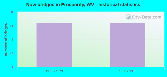
- New bridges - historical statistics
- 81970-1979
- 81980-1989


- Bridge Condition - Deck
- 10.0%Very good
- 40.0%Satisfactory
- 50.0%Fair

- Bridge Condition - Superstructure
- 30.0%Good
- 40.0%Satisfactory
- 30.0%Fair

- Bridge Condition - Substructure
- 60.0%Satisfactory
- 10.0%Fair
- 30.0%Poor
Find on map >> Show street view
Structure Number: 41A152, Location: 0.58 MI. E. I-77 (Lat: 37.839419, Lng: -81.212189), Route carried "on" structure: Alternate US 1900, Year Built: 1979, Status: Open, Structure Length: 3.84m (12.60ft), Average Daily Traffic: 6,700 (year 2018), Truck Traffic: 7%, Average Future Daily Traffic: 8,442 (year 2038), Design Load: HS 20, Features Intersected: CR 4/1, Facility Carried by Structure: US 19A EB
Minimum Vertical Clearance: 30+ m (98+ ft), Kilometerpoint: 0.933, Lanes on structure: 2, Lanes under structure: 1, Base Highway Network: Yes, Owner: State Highway Agency, Approaching Roadway Width: 9.1m (29.9ft), Skew: 1 degrees, Material/Design: Steel continuous, Design/Construction: Stringer/Multi-beam, Number Of Spans In Main Unit: 1, Number Of Approach Spans: 2, Length of Maximum Span: 14.3m (46.9ft), Curb-To-Curb Width: 15.1m (49.5ft), Out-to-Out Width: 16.2m (53.1ft)
Condition: Deck: Fair, Superstructure: Fair, Substructure: Poor, Operating Rating: 65.3 metric tons, Method Used To Determine Operating Rating: Load Factor (LF), Inventory Rating: 39.0 metric tons, Method Used To Determine Inventory Rating: Load Factor (LF), Structural Evaluation: Meets minimum limits, Deck Geometry: Superior to present desirable criteria, Underclear: Better than present minimum criteria, Approach Roadway Alignment: Equal to present desirable criteria, Designated Inspection Frequency: Every 24 months, Inspection Date: May 2020, Deck Structure Type: Concrete Cast-file-Place, Wearing Surface/Protective System: Wearing Surface: Monolithic Concrete, Deck Protection: Epoxy Coated Reinforcing
Find on map >> Show street view
Structure Number: 41A153, Location: 0.58 MI. E OF I-77 (Lat: 37.839550, Lng: -81.212639), Route carried "on" structure: Alternate US 1900, Year Built: 1979, Status: Open, Structure Length: 3.85m (12.63ft), Average Daily Traffic: 2,300 (year 2018), Truck Traffic: 7%, Average Future Daily Traffic: 2,898 (year 2038), Design Load: HS 20, Features Intersected: CR 4/1, Facility Carried by Structure: US. 19A WB
Minimum Vertical Clearance: 30+ m (98+ ft), Kilometerpoint: 0.933, Lanes on structure: 3, Lanes under structure: 1, Base Highway Network: Yes, Owner: State Highway Agency, Approaching Roadway Width: 11.0m (36.1ft), Skew: 1 degrees, Material/Design: Steel continuous, Design/Construction: Stringer/Multi-beam, Number Of Spans In Main Unit: 1, Number Of Approach Spans: 2, Length of Maximum Span: 14.3m (46.9ft), Curb-To-Curb Width: 13.3m (43.6ft), Out-to-Out Width: 14.3m (46.9ft)
Condition: Deck: Fair, Superstructure: Fair, Substructure: Poor, Operating Rating: 59.9 metric tons, Method Used To Determine Operating Rating: Load Factor (LF), Inventory Rating: 35.4 metric tons, Method Used To Determine Inventory Rating: Load Factor (LF), Structural Evaluation: Meets minimum limits, Deck Geometry: High priority of replacement, Underclear: Somewhat better than minimum adequacy, Approach Roadway Alignment: Equal to present desirable criteria, Length Of Structure Improvement: 3.74m (12.27ft), Designated Inspection Frequency: Every 24 months, Inspection Date: July 2020, Bridge Improvement Cost: $3,500,000, Roadway Improvement Cost: $500,000, Total Project Cost: $4,000,000 ( Estimate for 2020), Deck Structure Type: Concrete Cast-file-Place, Wearing Surface/Protective System: Wearing Surface: Monolithic Concrete, Deck Protection: Epoxy Coated Reinforcing
Find on map >> Show street view
Structure Number: 41A195, Location: 0.29 MI W OF US 19 RAMP (Lat: 37.850911, Lng: -81.197150), Route carried "on" structure: Alternate US 1900, Year Built: 1979, Status: Open, Structure Length: 6.05m (19.85ft), Average Daily Traffic: 6,700 (year 2019), Truck Traffic: 7%, Average Future Daily Traffic: 9,246 (year 2039), Design Load: HS 20, Features Intersected: WV 16, Facility Carried by Structure: US RT 19 ALT
Minimum Vertical Clearance: 30+ m (98+ ft), Kilometerpoint: 2.865, Lanes on structure: 2, Lanes under structure: 4, Base Highway Network: Yes, Owner: State Highway Agency, Approaching Roadway Width: 9.1m (29.9ft), Skew: 1 degrees, Material/Design: Steel continuous, Design/Construction: Stringer/Multi-beam, Number Of Spans In Main Unit: 1, Number Of Approach Spans: 2, Length of Maximum Span: 25.7m (84.3ft), Curb-To-Curb Width: 12.5m (41.0ft), Out-to-Out Width: 13.6m (44.6ft)
Condition: Deck: Fair, Superstructure: Satisfactory, Substructure: Poor, Operating Rating: 65.3 metric tons, Method Used To Determine Operating Rating: Load Factor (LF), Inventory Rating: 39.0 metric tons, Method Used To Determine Inventory Rating: Load Factor (LF), Structural Evaluation: Meets minimum limits, Deck Geometry: Better than present minimum criteria, Underclear: Equal to present desirable criteria, Approach Roadway Alignment: Equal to present desirable criteria, Length Of Structure Improvement: 5.92m (19.42ft), Designated Inspection Frequency: Every 24 months, Inspection Date: April 2021, Bridge Improvement Cost: $3,500,000, Roadway Improvement Cost: $500,000, Total Project Cost: $4,000,000 ( Estimate for 2021), Deck Structure Type: Concrete Cast-file-Place, Wearing Surface/Protective System: Wearing Surface: Monolithic Concrete, Deck Protection: Epoxy Coated Reinforcing
Find on map >> Show street view
Structure Number: 41A199, Location: 0.29 MI W OF US 19 (Lat: 37.851081, Lng: -81.197219), Route carried "on" structure: Alternate US 1900, Year Built: 1979, Status: Open, Structure Length: 6.05m (19.85ft), Average Daily Traffic: 6,700 (year 2019), Truck Traffic: 7%, Average Future Daily Traffic: 9,246 (year 2039), Design Load: HS 20, Features Intersected: US 19 ALT, Facility Carried by Structure: US RT 19 ALT
Minimum Vertical Clearance: 30+ m (98+ ft), Kilometerpoint: 2.865, Lanes on structure: 2, Lanes under structure: 4, Base Highway Network: Yes, Owner: State Highway Agency, Approaching Roadway Width: 9.1m (29.9ft), Skew: 1 degrees, Material/Design: Steel continuous, Design/Construction: Stringer/Multi-beam, Number Of Spans In Main Unit: 1, Number Of Approach Spans: 2, Length of Maximum Span: 25.7m (84.3ft), Curb-To-Curb Width: 12.5m (41.0ft), Out-to-Out Width: 13.6m (44.6ft)
Condition: Deck: Fair, Superstructure: Fair, Substructure: Fair, Operating Rating: 65.3 metric tons, Method Used To Determine Operating Rating: Load Factor (LF), Inventory Rating: 39.0 metric tons, Method Used To Determine Inventory Rating: Load Factor (LF), Structural Evaluation: Somewhat better than minimum adequacy, Deck Geometry: Better than present minimum criteria, Underclear: Equal to present desirable criteria, Approach Roadway Alignment: Equal to present desirable criteria, Length Of Structure Improvement: 5.92m (19.42ft), Designated Inspection Frequency: Every 24 months, Inspection Date: April 2021, Bridge Improvement Cost: $3,500,000, Roadway Improvement Cost: $1,000,000, Total Project Cost: $4,500,000 ( Estimate for 2019), Deck Structure Type: Concrete Cast-file-Place, Wearing Surface/Protective System: Wearing Surface: Monolithic Concrete, Deck Protection: Epoxy Coated Reinforcing
Find on map >> Show street view
Structure Number: 41A201, Location: 0.72 MI S OF RT 19 (Lat: 37.825531, Lng: -81.213631), Route carried "on" structure: Interstate 7700, Year Built: 1980, Status: Open, Structure Length: 5.73m (18.80ft), Average Daily Traffic: 21,034 (year 2020), Truck Traffic: 17%, Average Future Daily Traffic: 44,171 (year 2040), Design Load: HS 20+Mod, Features Intersected: Raleigh Co. 4 & 6 Conn., Facility Carried by Structure: I-77 NB
Minimum Vertical Clearance: 30+ m (98+ ft), Kilometerpoint: 75.462, Lanes on structure: 2, Lanes under structure: 2, Base Highway Network: Yes, Toll: On Interstate toll segment, Owner: State Toll Authority, Approaching Roadway Width: 14.9m (48.9ft), Material/Design: Steel continuous, Design/Construction: Stringer/Multi-beam, Number Of Spans In Main Unit: 1, Number Of Approach Spans: 2, Length of Maximum Span: 21.3m (69.9ft), Curb-To-Curb Width: 12.5m (41.0ft), Out-to-Out Width: 13.6m (44.6ft)
Condition: Deck: Satisfactory, Superstructure: Satisfactory, Substructure: Satisfactory, Operating Rating: 62.6 metric tons, Method Used To Determine Operating Rating: Load Factor (LF), Inventory Rating: 37.2 metric tons, Method Used To Determine Inventory Rating: Load Factor (LF), Structural Evaluation: Equal to present minimum criteria, Deck Geometry: Better than present minimum criteria, Underclear: Superior to present desirable criteria, Approach Roadway Alignment: Equal to present desirable criteria, Designated Inspection Frequency: Every 24 months, Inspection Date: April 2021, Deck Structure Type: Concrete Cast-file-Place, Wearing Surface/Protective System: Wearing Surface: Epoxy Overlay, Membrane: Epoxy, Deck Protection: Epoxy Coated Reinforcing
Find on map >> Show street view
Structure Number: 41A202, Location: 0.72 MI S OF RT 19 (Lat: 37.825550, Lng: -81.214000), Route carried "on" structure: Interstate 7700, Year Built: 1980, Status: Open, Structure Length: 5.73m (18.80ft), Average Daily Traffic: 21,034 (year 2020), Truck Traffic: 17%, Average Future Daily Traffic: 44,171 (year 2040), Design Load: HS 20+Mod, Features Intersected: Raleigh Co. 4 & 6 Conn., Facility Carried by Structure: I-77 SB
Minimum Vertical Clearance: 30+ m (98+ ft), Kilometerpoint: 75.462, Lanes on structure: 2, Lanes under structure: 2, Base Highway Network: Yes, Toll: On Interstate toll segment, Owner: State Toll Authority, Approaching Roadway Width: 20.1m (65.9ft), Material/Design: Steel continuous, Design/Construction: Stringer/Multi-beam, Number Of Spans In Main Unit: 1, Number Of Approach Spans: 2, Length of Maximum Span: 21.3m (69.9ft), Curb-To-Curb Width: 19.1m (62.7ft), Out-to-Out Width: 20.2m (66.3ft)
Condition: Deck: Very good, Superstructure: Satisfactory, Substructure: Satisfactory, Operating Rating: 59.9 metric tons, Method Used To Determine Operating Rating: Load Factor (LF), Inventory Rating: 36.3 metric tons, Method Used To Determine Inventory Rating: Load Factor (LF), Structural Evaluation: Equal to present minimum criteria, Deck Geometry: Superior to present desirable criteria, Underclear: Superior to present desirable criteria, Approach Roadway Alignment: Equal to present desirable criteria, Designated Inspection Frequency: Every 24 months, Inspection Date: April 2021, Deck Structure Type: Concrete Cast-file-Place, Wearing Surface/Protective System: Wearing Surface: Epoxy Overlay, Membrane: Epoxy, Deck Protection: Epoxy Coated Reinforcing
Find on map >> Show street view
Structure Number: 41A212, Location: 0.01 MI N FROM I-77 (Lat: 37.835311, Lng: -81.215419), Route carried "on" structure: Ramp US 1900, Year Built: 1980, Status: Open, Structure Length: 8.33m (27.33ft), Average Daily Traffic: 1,352 (year 2018), Truck Traffic: 17%, Average Future Daily Traffic: 2,840 (year 2038), Design Load: HS 20+Mod, Features Intersected: I-77, Facility Carried by Structure: US RT 19 EB
Minimum Vertical Clearance: 30+ m (98+ ft), Kilometerpoint: 0.563, Lanes on structure: 1, Lanes under structure: 5, Base Highway Network: Yes, Toll: On Interstate toll segment, Owner: State Toll Authority, Approaching Roadway Width: 7.3m (24.0ft), Skew: 2 degrees, Material/Design: Steel continuous, Design/Construction: Stringer/Multi-beam, Number Of Spans In Main Unit: 1, Number Of Approach Spans: 2, Length of Maximum Span: 34.1m (111.9ft), Curb-To-Curb Width: 8.8m (28.9ft), Out-to-Out Width: 9.9m (32.5ft)
Condition: Deck: Satisfactory, Superstructure: Good, Substructure: Satisfactory, Operating Rating: 58.0 metric tons, Method Used To Determine Operating Rating: Load Factor (LF), Inventory Rating: 34.5 metric tons, Method Used To Determine Inventory Rating: Load Factor (LF), Structural Evaluation: Equal to present minimum criteria, Deck Geometry: Superior to present desirable criteria, Underclear: Equal to present minimum criteria, Approach Roadway Alignment: Equal to present desirable criteria, Designated Inspection Frequency: Every 24 months, Inspection Date: April 2021, Deck Structure Type: Concrete Cast-file-Place, Wearing Surface/Protective System: Wearing Surface: Monolithic Concrete, Deck Protection: Epoxy Coated Reinforcing
Find on map >> Show street view
Structure Number: 41A213, Location: 0.01 MI N FROM I-77 (Lat: 37.835431, Lng: -81.215569), Route carried "on" structure: Ramp US 1900, Year Built: 1980, Status: Open, Structure Length: 8.33m (27.33ft), Average Daily Traffic: 7,625 (year 2018), Truck Traffic: 17%, Average Future Daily Traffic: 16,013 (year 2038), Design Load: HS 20+Mod, Features Intersected: I-77, Facility Carried by Structure: US RT 19 WB
Minimum Vertical Clearance: 30+ m (98+ ft), Kilometerpoint: 0.563, Lanes on structure: 1, Lanes under structure: 5, Base Highway Network: Yes, Toll: On Interstate toll segment, Owner: State Toll Authority, Approaching Roadway Width: 7.3m (24.0ft), Skew: 2 degrees, Material/Design: Steel continuous, Design/Construction: Stringer/Multi-beam, Number Of Spans In Main Unit: 1, Number Of Approach Spans: 2, Length of Maximum Span: 34.1m (111.9ft), Curb-To-Curb Width: 8.8m (28.9ft), Out-to-Out Width: 9.9m (32.5ft)
Condition: Deck: Fair, Superstructure: Good, Substructure: Satisfactory, Operating Rating: 58.0 metric tons, Method Used To Determine Operating Rating: Load Factor (LF), Inventory Rating: 34.5 metric tons, Method Used To Determine Inventory Rating: Load Factor (LF), Structural Evaluation: Equal to present minimum criteria, Deck Geometry: Superior to present desirable criteria, Underclear: Equal to present minimum criteria, Approach Roadway Alignment: Equal to present desirable criteria, Designated Inspection Frequency: Every 24 months, Inspection Date: April 2021, Deck Structure Type: Concrete Cast-file-Place, Wearing Surface/Protective System: Wearing Surface: Monolithic Concrete, Deck Protection: Epoxy Coated Reinforcing
Find on map >> Show street view
Structure Number: 41A217, Location: 0.39 MI N OF CORR L I/C (Lat: 37.837939, Lng: -81.221961), Route carried "on" structure: Interstate 7700, Year Built: 1983, Status: Open, Structure Length: 5.48m (17.98ft), Average Daily Traffic: 21,035 (year 2020), Truck Traffic: 17%, Average Future Daily Traffic: 30,709 (year 2040), Design Load: HS 20+Mod, Features Intersected: Route 4/1, Facility Carried by Structure: I-77 NB
Minimum Vertical Clearance: 30+ m (98+ ft), Kilometerpoint: 77.249, Lanes on structure: 2, Lanes under structure: 1, Base Highway Network: Yes, Toll: On Interstate toll segment, Owner: State Toll Authority, Approaching Roadway Width: 12.8m (42.0ft), Skew: 13 degrees, Material/Design: Steel continuous, Design/Construction: Stringer/Multi-beam, Number Of Spans In Main Unit: 1, Number Of Approach Spans: 2, Length of Maximum Span: 21.6m (70.9ft), Curb-To-Curb Width: 14.9m (48.9ft), Out-to-Out Width: 15.9m (52.2ft)
Condition: Deck: Satisfactory, Superstructure: Satisfactory, Substructure: Satisfactory, Operating Rating: 67.1 metric tons, Method Used To Determine Operating Rating: Load Factor (LF), Inventory Rating: 39.9 metric tons, Method Used To Determine Inventory Rating: Load Factor (LF), Structural Evaluation: Equal to present minimum criteria, Deck Geometry: Superior to present desirable criteria, Underclear: Superior to present desirable criteria, Approach Roadway Alignment: Equal to present desirable criteria, Designated Inspection Frequency: Every 24 months, Inspection Date: October 2021, Deck Structure Type: Concrete Cast-file-Place, Wearing Surface/Protective System: Wearing Surface: Monolithic Concrete, Deck Protection: Epoxy Coated Reinforcing
Find on map >> Show street view
Structure Number: 41A23, Location: 0.40 MI. N. US. 119 (Lat: 37.837681, Lng: -81.222200), Route carried "on" structure: Interstate 7700, Year Built: 1984, Status: Open, Structure Length: 5.81m (19.06ft), Average Daily Traffic: 12,921 (year 2018), Truck Traffic: 17%, Average Future Daily Traffic: 25,842 (year 2038), Design Load: HS 20+Mod, Features Intersected: County Route 4/1, Facility Carried by Structure: I-77 SB.
Minimum Vertical Clearance: 30+ m (98+ ft), Kilometerpoint: 77.249, Lanes on structure: 3, Lanes under structure: 1, Base Highway Network: Yes, Toll: On Interstate toll segment, Owner: State Toll Authority, Approaching Roadway Width: 12.8m (42.0ft), Skew: 3 degrees, Material/Design: Steel continuous, Design/Construction: Stringer/Multi-beam, Number Of Spans In Main Unit: 1, Number Of Approach Spans: 2, Length of Maximum Span: 22.6m (74.1ft), Curb-To-Curb Width: 14.3m (46.9ft), Out-to-Out Width: 15.3m (50.2ft)
Condition: Deck: Satisfactory, Superstructure: Good, Substructure: Satisfactory, Operating Rating: 60.8 metric tons, Method Used To Determine Operating Rating: Load Factor (LF), Inventory Rating: 36.3 metric tons, Method Used To Determine Inventory Rating: Load Factor (LF), Structural Evaluation: Equal to present minimum criteria, Deck Geometry: Meets minimum limits, Underclear: Meets minimum limits, Approach Roadway Alignment: Equal to present desirable criteria, Designated Inspection Frequency: Every 24 months, Inspection Date: June 2020, Deck Structure Type: Concrete Cast-file-Place, Wearing Surface/Protective System: Wearing Surface: Monolithic Concrete, Deck Protection: Epoxy Coated Reinforcing
Find on map >> Show street view
Structure Number: 41A152, Location: 0.58 MI. E. I-77 (Lat: 37.839450, Lng: -81.212200), Route carried "under" structure: County highway 400, Year Built: 1979, Structure Length: 0. m, Average Daily Traffic: 250 (year 0009), Truck Traffic: 6%, Features Intersected: CR 4/1, Facility Carried by Structure: US 19A EB
Minimum Vertical Clearance: 4.93m (16.17ft), Kilometerpoint: 0.933, Lanes on structure: 2, Lanes under structure: 1, Length of Maximum Span: 14.3m (46.9ft)
Find on map >> Show street view
Structure Number: 41A153, Location: 0.58 MI. E OF I-77 (Lat: 37.839550, Lng: -81.212639), Route carried "under" structure: County highway 401, Year Built: 1979, Structure Length: 0. m, Average Daily Traffic: 250 (year 0009), Truck Traffic: 6%, Features Intersected: CR 4/1, Facility Carried by Structure: US. 19A WB
Minimum Vertical Clearance: 6.25m (20.51ft), Kilometerpoint: 0.257, Lanes on structure: 3, Lanes under structure: 1, Length of Maximum Span: 14.3m (46.9ft)
Find on map >> Show street view
Structure Number: 41A195, Location: 0.29 MI W OF US 19 RAMP (Lat: 37.850911, Lng: -81.197150), Route carried "under" structure: State highway 1600, Year Built: 1979, Structure Length: 0. m, Average Daily Traffic: 4,900 (year 0009), Truck Traffic: 6%, Features Intersected: WV 16, Facility Carried by Structure: US RT 19 ALT
Minimum Vertical Clearance: 5.21m (17.09ft), Kilometerpoint: 37.240, Lanes on structure: 2, Lanes under structure: 4, Length of Maximum Span: 25.7m (84.3ft)
Find on map >> Show street view
Structure Number: 41A199, Location: 0.29 MI W OF US 19 (Lat: 37.851089, Lng: -81.197211), Route carried "under" structure: State highway 1600, Year Built: 1979, Structure Length: 0. m, Average Daily Traffic: 4,900 (year 0006), Truck Traffic: 6%, Features Intersected: US 19 ALT, Facility Carried by Structure: US RT 19 ALT
Minimum Vertical Clearance: 5.21m (17.09ft), Kilometerpoint: 37.240, Lanes on structure: 2, Lanes under structure: 4, Length of Maximum Span: 25.7m (84.3ft)
Find on map >> Show street view
Structure Number: 41A212, Location: 0.01 MI N FROM I-77 (Lat: 37.835311, Lng: -81.215419), Route carried "under" structure: Interstate 7700, Year Built: 1980, Structure Length: 0. m, Average Daily Traffic: 17,500 (year 0006), Truck Traffic: 25%, Features Intersected: I-77, Facility Carried by Structure: US RT 19 EB
Minimum Vertical Clearance: 5.41m (17.75ft), Kilometerpoint: 76.573, Lanes on structure: 1, Lanes under structure: 5, Toll: On Interstate toll segment, Length of Maximum Span: 34.1m (111.9ft)
Find on map >> Show street view
Structure Number: 41A213, Location: 0.01 MI N FROM I-77 (Lat: 37.835431, Lng: -81.215569), Route carried "under" structure: Interstate 7700, Year Built: 1980, Structure Length: 0. m, Average Daily Traffic: 17,500 (year 0006), Truck Traffic: 25%, Features Intersected: I-77, Facility Carried by Structure: US RT 19 WB
Minimum Vertical Clearance: 6.22m (20.41ft), Kilometerpoint: 76.589, Lanes on structure: 1, Lanes under structure: 5, Toll: On Interstate toll segment, Length of Maximum Span: 34.1m (111.9ft)