Bridge Statistics for Prospect, Louisiana (LA)
Condition, Traffic, Stress, Structural Evaluation, Project Costs
- National Bridge Inventory (NBI) Statistics
- 12Number of bridges
- 75ft / 23.1mTotal length
- $1,083,000Total costs
- 10,330Total average daily traffic
- 1,369Total average daily truck traffic
- 17,468Total future (year 2036) average daily traffic
- National Bridge Inventory (NBI) Registered Bridges for Prospect
- No street view available for this location
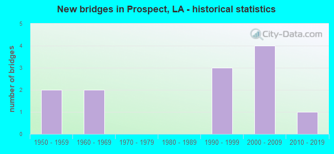
- New bridges - historical statistics
- 21950-1959
- 21960-1969
- 31990-1999
- 42000-2009
- 12010-2019

- Bridge Condition - Deck
- 50.0%Very good
- 16.7%Good
- 33.3%Fair

- Bridge Condition - Superstructure
- 50.0%Very good
- 16.7%Good
- 33.3%Fair

- Bridge Condition - Substructure
- 50.0%Very good
- 16.7%Good
- 33.3%Satisfactory

- Bridge Condition - Channel
- 25.0%Very good
- 8.3%Good
- 58.3%Satisfactory
- 8.3%Fair

- Bridge Condition - Culverts
- 50.0%Very good
- 33.3%Good
- 16.7%Satisfactory
Find on map >> Show street view
Structure Number: 82200000080585, Location: 0.25 MI. EAST OF US 167 (Lat: 31.472381, Lng: -92.487900), Route carried "on" structure: County highway , Year Built: 2005, Status: Open, Structure Length: 0.67m (2.20ft), Truck Traffic: 10%, Design Load: HS 20, Features Intersected: CREEK, Facility Carried by Structure: Air Base Rd
Minimum Vertical Clearance: 30+ m (98+ ft), Kilometerpoint: 8.478, Lanes on structure: 2, Owner: County Highway Agency, Approaching Roadway Width: 12.2m (40.0ft), Skew: 36 degrees, Material/Design: Steel, Design/Construction: Culvert, Number Of Spans In Main Unit: 3, Length of Maximum Span: 1.8m (5.9ft)
Condition: Channel: Very good, Culverts: Very good, Operating Rating: 97.2 metric tons, Method Used To Determine Operating Rating: Load and Resistance Factor Rating (LRFR) rating reported by rating factor(RF) method using HL-93 loadings, Inventory Rating: 74.5 metric tons, Method Used To Determine Inventory Rating: Load and Resistance Factor Rating (LRFR) rating reported by rating factor(RF) method using HL-93 loadings, Structural Evaluation: Equal to present desirable criteria, Waterway Adequacy: Better than present minimum criteria, Approach Roadway Alignment: Better than present minimum criteria, Designated Inspection Frequency: Every 24 months, Inspection Date: April 2021
Find on map >> Show street view
Structure Number: 82200000080586, Location: .29 MILE EAST OF US 167 (Lat: 31.472261, Lng: -92.486900), Route carried "on" structure: County highway , Year Built: 2005, Status: Open, Structure Length: 0.98m (3.22ft), Truck Traffic: 10%, Design Load: HS 20, Features Intersected: FLAGON CREEK, Facility Carried by Structure: Air Base Rd
Minimum Vertical Clearance: 30+ m (98+ ft), Kilometerpoint: 8.385, Lanes on structure: 2, Owner: County Highway Agency, Approaching Roadway Width: 10.7m (35.1ft), Skew: 37 degrees, Material/Design: Concrete, Design/Construction: Culvert, Number Of Spans In Main Unit: 3, Length of Maximum Span: 2.7m (8.9ft), Curb-To-Curb Width: 9.4m (30.8ft), Out-to-Out Width: 17.1m (56.1ft)
Condition: Channel: Very good, Culverts: Very good, Operating Rating: 42.1 metric tons, Method Used To Determine Operating Rating: Load and Resistance Factor Rating (LRFR) rating reported by rating factor(RF) method using HL-93 loadings, Inventory Rating: 32.4 metric tons, Method Used To Determine Inventory Rating: Load and Resistance Factor Rating (LRFR) rating reported by rating factor(RF) method using HL-93 loadings, Structural Evaluation: Equal to present desirable criteria, Deck Geometry: Better than present minimum criteria, Waterway Adequacy: Better than present minimum criteria, Approach Roadway Alignment: Better than present minimum criteria, Designated Inspection Frequency: Every 24 months, Inspection Date: April 2021, Deck Structure Type: Concrete Precast Panels
Find on map >> Show street view
Structure Number: 82200000080676, Location: 5.72 MI N of Jct US 71 (Lat: 31.496581, Lng: -92.519900), Route carried "on" structure: County highway , Year Built: 2017, Status: Open, Structure Length: 2.44m (8.01ft), Average Daily Traffic: 200 (year 2016), Truck Traffic: 1%, Average Future Daily Traffic: 450 (year 2037), Design Load: HL 93, Features Intersected: Gray's Creek, Facility Carried by Structure: Rock Hill Road
Minimum Vertical Clearance: 30+ m (98+ ft), Kilometerpoint: 0.000, Lanes on structure: 2, Owner: County Highway Agency, Approaching Roadway Width: 5.8m (19.0ft), Skew: 1 degrees, Material/Design: Concrete, Design/Construction: Slab, Number Of Spans In Main Unit: 4, Length of Maximum Span: 6.1m (20.0ft), Curb-To-Curb Width: 7.1m (23.3ft), Out-to-Out Width: 8.2m (26.9ft)
Condition: Deck: Very good, Superstructure: Very good, Substructure: Very good, Channel: Very good, Operating Rating: 59.9 metric tons, Method Used To Determine Operating Rating: Load and Resistance Factor Rating (LRFR) rating reported by rating factor(RF) method using HL-93 loadings, Inventory Rating: 46.0 metric tons, Method Used To Determine Inventory Rating: Load and Resistance Factor Rating (LRFR) rating reported by rating factor(RF) method using HL-93 loadings, Structural Evaluation: Equal to present desirable criteria, Deck Geometry: Meets minimum limits, Waterway Adequacy: Equal to present desirable criteria, Approach Roadway Alignment: Equal to present desirable criteria, Designated Inspection Frequency: Every 24 months, Inspection Date: March 2021, Deck Structure Type: Concrete Precast Panels
Find on map >> Show street view
Structure Number: 8220000070076, Location: 1.36 MILES N JCT LA 1241 (Lat: 31.465811, Lng: -92.514500), Route carried "on" structure: County highway , Year Built: 2009, Status: Open, Structure Length: 1.22m (4.00ft), Average Daily Traffic: 250 (year 2009), Truck Traffic: 1%, Average Future Daily Traffic: 420 (year 2036), Design Load: HS 20, Features Intersected: MOCCASIN BRANCH, Facility Carried by Structure: Grays Creek Rd
Minimum Vertical Clearance: 30+ m (98+ ft), Kilometerpoint: 6.545, Lanes on structure: 2, Owner: County Highway Agency, Approaching Roadway Width: 5.5m (18.0ft), Skew: 30 degrees, Material/Design: Prestressed concrete, Design/Construction: Stringer/Multi-beam, Number Of Spans In Main Unit: 1, Length of Maximum Span: 12.2m (40.0ft), Curb-To-Curb Width: 7.3m (24.0ft), Out-to-Out Width: 8.1m (26.6ft)
Condition: Deck: Very good, Superstructure: Very good, Substructure: Very good, Channel: Satisfactory, Operating Rating: 54.4 metric tons, Method Used To Determine Operating Rating: Load and Resistance Factor Rating (LRFR) rating reported by rating factor(RF) method using HL-93 loadings, Inventory Rating: 34.0 metric tons, Method Used To Determine Inventory Rating: Load and Resistance Factor Rating (LRFR) rating reported by rating factor(RF) method using HL-93 loadings, Structural Evaluation: Equal to present desirable criteria, Deck Geometry: Somewhat better than minimum adequacy, Waterway Adequacy: Superior to present desirable criteria, Approach Roadway Alignment: Superior to present desirable criteria, Designated Inspection Frequency: Every 24 months, Inspection Date: March 2021, Deck Structure Type: Concrete Cast-file-Place, Wearing Surface/Protective System: Wearing Surface: Monolithic Concrete
Find on map >> Show street view
Structure Number: 82200000700762, Location: 1.5 MI. WEST OF US 167 (Lat: 31.461519, Lng: -92.517000), Route carried "on" structure: County highway , Year Built: 2009, Status: Open, Structure Length: 1.22m (4.00ft), Average Daily Traffic: 100 (year 2006), Truck Traffic: 1%, Average Future Daily Traffic: 168 (year 2036), Design Load: HS 20, Features Intersected: MOCCASIN BRANCH, Facility Carried by Structure: Frazier Ceme Rd
Minimum Vertical Clearance: 30+ m (98+ ft), Kilometerpoint: 0.708, Lanes on structure: 2, Owner: County Highway Agency, Approaching Roadway Width: 5.5m (18.0ft), Skew: 30 degrees, Material/Design: Prestressed concrete, Design/Construction: Stringer/Multi-beam, Number Of Spans In Main Unit: 1, Length of Maximum Span: 12.2m (40.0ft), Curb-To-Curb Width: 8.5m (27.9ft), Out-to-Out Width: 9.4m (30.8ft)
Condition: Deck: Very good, Superstructure: Very good, Substructure: Very good, Channel: Satisfactory, Operating Rating: 48.9 metric tons, Method Used To Determine Operating Rating: Load and Resistance Factor Rating (LRFR) rating reported by rating factor(RF) method using HL-93 loadings, Inventory Rating: 28.2 metric tons, Method Used To Determine Inventory Rating: Load and Resistance Factor Rating (LRFR) rating reported by rating factor(RF) method using HL-93 loadings, Structural Evaluation: Better than present minimum criteria, Deck Geometry: Better than present minimum criteria, Waterway Adequacy: Superior to present desirable criteria, Approach Roadway Alignment: Meets minimum limits, Designated Inspection Frequency: Every 24 months, Inspection Date: March 2021, Deck Structure Type: Concrete Cast-file-Place, Wearing Surface/Protective System: Wearing Surface: Monolithic Concrete
Find on map >> Show street view
Structure Number: 82200090200561, Location: 2.99 MI. SOUTH OF LA 1241 (Lat: 31.420319, Lng: -92.518500), Route carried "on" structure: US 71, Year Built: 1969, Status: Open, Structure Length: 6.10m (20.01ft), Average Daily Traffic: 2,400 (year 2016), Truck Traffic: 15%, Average Future Daily Traffic: 4,032 (year 2036), Design Load: HS 20, Features Intersected: HUDSON CREEK
Minimum Vertical Clearance: 30+ m (98+ ft), Kilometerpoint: 0.867, Lanes on structure: 2, Base Highway Network: Yes (Inventory Route: 9-02-1, Subroute: 10), Owner: State Highway Agency, Approaching Roadway Width: 13.4m (44.0ft), Skew: 31 degrees, Material/Design: Concrete, Design/Construction: Slab, Number Of Spans In Main Unit: 10, Length of Maximum Span: 6.1m (20.0ft), Curb-To-Curb Width: 8.5m (27.9ft), Out-to-Out Width: 10.2m (33.5ft)
Condition: Deck: Good, Superstructure: Good, Substructure: Good, Channel: Satisfactory, Operating Rating: 71.7 metric tons, Method Used To Determine Operating Rating: Load Factor (LF), Inventory Rating: 43.5 metric tons, Method Used To Determine Inventory Rating: Load Factor (LF), Structural Evaluation: Better than present minimum criteria, Deck Geometry: Meets minimum limits, Waterway Adequacy: Equal to present minimum criteria, Approach Roadway Alignment: Equal to present desirable criteria, Designated Inspection Frequency: Every 24 months, Inspection Date: July 2020, Deck Structure Type: Concrete Cast-file-Place, Wearing Surface/Protective System: Wearing Surface: Monolithic Concrete
Find on map >> Show street view
Structure Number: 82200090201241, Location: 2.4 MI SOUTH OF LA 1241 (Lat: 31.425239, Lng: -92.527900), Route carried "on" structure: US 71, Year Built: 1969, Status: Open, Structure Length: 0.67m (2.20ft), Average Daily Traffic: 2,400 (year 2016), Truck Traffic: 15%, Average Future Daily Traffic: 4,032 (year 2036), Design Load: HS 20, Features Intersected: CREEK
Minimum Vertical Clearance: 30+ m (98+ ft), Kilometerpoint: 1.939, Lanes on structure: 2, Base Highway Network: Yes (Inventory Route: 9-02-1, Subroute: 10), Owner: State Highway Agency, Approaching Roadway Width: 13.4m (44.0ft), Skew: 30 degrees, Material/Design: Concrete, Design/Construction: Culvert, Number Of Spans In Main Unit: 4, Length of Maximum Span: 1.5m (4.9ft)
Condition: Channel: Satisfactory, Culverts: Good, Operating Rating: 42.1 metric tons, Method Used To Determine Operating Rating: Load and Resistance Factor Rating (LRFR) rating reported by rating factor(RF) method using HL-93 loadings, Inventory Rating: 32.4 metric tons, Method Used To Determine Inventory Rating: Load and Resistance Factor Rating (LRFR) rating reported by rating factor(RF) method using HL-93 loadings, Structural Evaluation: Better than present minimum criteria, Waterway Adequacy: Meets minimum limits, Approach Roadway Alignment: Equal to present minimum criteria, Designated Inspection Frequency: Every 24 months, Inspection Date: July 2020, Deck Structure Type: Concrete Cast-file-Place
Find on map >> Show street view
Structure Number: 82208220503001, Location: 3.0 MI EAST OF US 71 (Lat: 31.447100, Lng: -92.518200), Route carried "on" structure: State highway 1241, Year Built: 1958, Status: Open, Structure Length: 3.66m (12.01ft), Average Daily Traffic: 2,300 (year 2016), Truck Traffic: 14%, Average Future Daily Traffic: 3,864 (year 2036), Design Load: H 15, Features Intersected: HUDSON CREEK
Minimum Vertical Clearance: 30+ m (98+ ft), Kilometerpoint: 4.651, Lanes on structure: 2, Owner: State Highway Agency, Approaching Roadway Width: 7.9m (25.9ft), Skew: 30 degrees, Material/Design: Concrete, Design/Construction: Slab, Number Of Spans In Main Unit: 6, Length of Maximum Span: 6.1m (20.0ft), Curb-To-Curb Width: 7.3m (24.0ft), Out-to-Out Width: 9.0m (29.5ft)
Condition: Deck: Fair, Superstructure: Fair, Substructure: Satisfactory, Channel: Satisfactory, Operating Rating: 39.0 metric tons, Method Used To Determine Operating Rating: Load Factor (LF), Inventory Rating: 23.6 metric tons, Method Used To Determine Inventory Rating: Load Factor (LF), Structural Evaluation: Somewhat better than minimum adequacy, Deck Geometry: High priority of replacement, Waterway Adequacy: Equal to present minimum criteria, Approach Roadway Alignment: Better than present minimum criteria, Length Of Structure Improvement: 4.57m (14.99ft), Designated Inspection Frequency: Every 24 months, Inspection Date: July 2020, Bridge Improvement Cost: $390,000, Total Project Cost: $585,000 ( Estimate for 2016), Deck Structure Type: Concrete Cast-file-Place, Wearing Surface/Protective System: Wearing Surface: Monolithic Concrete
Find on map >> Show street view
Structure Number: 82208220503141, Location: 3.14 MI EAST OF US 71 (Lat: 31.447061, Lng: -92.516000), Route carried "on" structure: State highway 1241, Year Built: 1958, Status: Open, Structure Length: 3.05m (10.01ft), Average Daily Traffic: 2,300 (year 2016), Truck Traffic: 14%, Average Future Daily Traffic: 3,864 (year 2036), Design Load: H 15, Features Intersected: FRAZIER CREEK
Minimum Vertical Clearance: 30+ m (98+ ft), Kilometerpoint: 4.867, Lanes on structure: 2, Owner: State Highway Agency, Approaching Roadway Width: 7.9m (25.9ft), Skew: 30 degrees, Material/Design: Concrete, Design/Construction: Slab, Number Of Spans In Main Unit: 5, Length of Maximum Span: 6.1m (20.0ft), Curb-To-Curb Width: 7.3m (24.0ft), Out-to-Out Width: 9.0m (29.5ft)
Condition: Deck: Fair, Superstructure: Fair, Substructure: Satisfactory, Channel: Satisfactory, Operating Rating: 39.0 metric tons, Method Used To Determine Operating Rating: Load Factor (LF), Inventory Rating: 23.6 metric tons, Method Used To Determine Inventory Rating: Load Factor (LF), Structural Evaluation: Somewhat better than minimum adequacy, Deck Geometry: High priority of replacement, Waterway Adequacy: Equal to present minimum criteria, Approach Roadway Alignment: Better than present minimum criteria, Length Of Structure Improvement: 3.90m (12.80ft), Designated Inspection Frequency: Every 24 months, Inspection Date: July 2020, Bridge Improvement Cost: $332,000, Total Project Cost: $498,000 ( Estimate for 2016), Deck Structure Type: Concrete Cast-file-Place, Wearing Surface/Protective System: Wearing Surface: Monolithic Concrete
Find on map >> Show street view
Structure Number: 82231274923191, Location: 2.54 M. N. OF US 71 (Lat: 31.457269, Lng: -92.531400), Route carried "on" structure: County highway , Year Built: 1993, Status: Open, Structure Length: 0.79m (2.59ft), Average Daily Traffic: 50 (year 1992), Average Future Daily Traffic: 84 (year 2036), Design Load: HS 20, Features Intersected: HUDSON CREEK, Facility Carried by Structure: Hudson creek Rd
Minimum Vertical Clearance: 30+ m (98+ ft), Kilometerpoint: 3.883, Lanes on structure: 2, Owner: County Highway Agency, Approaching Roadway Width: 7.9m (25.9ft), Skew: 30 degrees, Material/Design: Concrete, Design/Construction: Culvert, Number Of Spans In Main Unit: 3, Length of Maximum Span: 2.4m (7.9ft)
Condition: Channel: Fair, Culverts: Good, Operating Rating: 42.1 metric tons, Method Used To Determine Operating Rating: Load and Resistance Factor Rating (LRFR) rating reported by rating factor(RF) method using HL-93 loadings, Inventory Rating: 32.4 metric tons, Method Used To Determine Inventory Rating: Load and Resistance Factor Rating (LRFR) rating reported by rating factor(RF) method using HL-93 loadings, Structural Evaluation: Better than present minimum criteria, Waterway Adequacy: Equal to present desirable criteria, Approach Roadway Alignment: Better than present minimum criteria, Designated Inspection Frequency: Every 24 months, Underwater Inspection Frequency: Every 60 months, Inspection Date: March 2021, Underwater Inspection Date: May 2018, Deck Structure Type: Concrete Cast-file-Place
Find on map >> Show street view
Structure Number: 82231281923171, Location: 0.84 M. W. OF JCT ROCK HI (Lat: 31.469019, Lng: -92.529800), Route carried "on" structure: County highway , Year Built: 1997, Status: Open, Structure Length: 0.98m (3.22ft), Average Daily Traffic: 280 (year 1996), Average Future Daily Traffic: 470 (year 2036), Design Load: HS 20, Features Intersected: COLEMAN CREEK, Facility Carried by Structure: Coleman Rd
Minimum Vertical Clearance: 30+ m (98+ ft), Kilometerpoint: 1.363, Lanes on structure: 2, Owner: County Highway Agency, Approaching Roadway Width: 7.9m (25.9ft), Skew: 36 degrees, Material/Design: Concrete, Design/Construction: Culvert, Number Of Spans In Main Unit: 4, Length of Maximum Span: 2.1m (6.9ft)
Condition: Channel: Good, Culverts: Very good, Operating Rating: 42.1 metric tons, Method Used To Determine Operating Rating: Load and Resistance Factor Rating (LRFR) rating reported by rating factor(RF) method using HL-93 loadings, Inventory Rating: 32.4 metric tons, Method Used To Determine Inventory Rating: Load and Resistance Factor Rating (LRFR) rating reported by rating factor(RF) method using HL-93 loadings, Structural Evaluation: Equal to present desirable criteria, Waterway Adequacy: Superior to present desirable criteria, Approach Roadway Alignment: Equal to present desirable criteria, Designated Inspection Frequency: Every 24 months, Inspection Date: March 2021, Deck Structure Type: Concrete Cast-file-Place
Find on map >> Show street view
Structure Number: 82231298923061, Location: 1.71 M. NW OF JCT US 167 (Lat: 31.498231, Lng: -92.510000), Route carried "on" structure: County highway , Year Built: 1993, Status: Open, Structure Length: 1.28m (4.20ft), Average Daily Traffic: 50 (year 1990), Average Future Daily Traffic: 84 (year 2036), Design Load: HS 20, Features Intersected: GRAYS CREEK, Facility Carried by Structure: Race Track Rd
Minimum Vertical Clearance: 30+ m (98+ ft), Kilometerpoint: 2.758, Lanes on structure: 2, Owner: County Highway Agency, Approaching Roadway Width: 7.9m (25.9ft), Skew: 37 degrees, Material/Design: Steel, Design/Construction: Culvert, Number Of Spans In Main Unit: 4, Length of Maximum Span: 2.4m (7.9ft)
Condition: Channel: Satisfactory, Culverts: Satisfactory, Operating Rating: 97.2 metric tons, Method Used To Determine Operating Rating: Load and Resistance Factor Rating (LRFR) rating reported by rating factor(RF) method using HL-93 loadings, Inventory Rating: 74.5 metric tons, Method Used To Determine Inventory Rating: Load and Resistance Factor Rating (LRFR) rating reported by rating factor(RF) method using HL-93 loadings, Structural Evaluation: Equal to present minimum criteria, Waterway Adequacy: Better than present minimum criteria, Approach Roadway Alignment: Better than present minimum criteria, Designated Inspection Frequency: Every 24 months, Inspection Date: March 2021