Bridge Statistics for Princess Anne, Maryland (MD)
Condition, Traffic, Stress, Structural Evaluation, Project Costs
- National Bridge Inventory (NBI) Statistics
- 13Number of bridges
- 59ft / 17.9mTotal length
- $10,000Total costs
- 95,382Total average daily traffic
- 7,730Total average daily truck traffic
- 94,883Total future (year 26) average daily traffic
- National Bridge Inventory (NBI) Registered Bridges for Princess Anne
- No street view available for this location
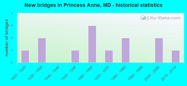
- New bridges - historical statistics
- 11920-1929
- 21930-1939
- 11950-1959
- 31960-1969
- 11970-1979
- 21980-1989
- 22000-2009
- 12010-2019

- Reconstructed bridges - Historical Statistics
- 11940-1949
- 21950-1959
- 01960-1969
- 01970-1979
- 11980-1989
- 01990-1999
- 02000-2009
- 12010-2019


- Bridge Condition - Deck
- 10.0%Very good
- 10.0%Good
- 60.0%Satisfactory
- 20.0%Fair

- Bridge Condition - Superstructure
- 10.0%Very good
- 10.0%Good
- 50.0%Satisfactory
- 30.0%Fair

- Bridge Condition - Substructure
- 10.0%Good
- 70.0%Satisfactory
- 20.0%Fair

- Bridge Condition - Channel
- 15.4%Very good
- 38.5%Good
- 38.5%Satisfactory
- 7.7%Fair

- Bridge Condition - Culverts
- 66.7%Good
- 33.3%Satisfactory
Find on map >> Show street view
Structure Number: 10000019000201, Location: 0.08 MILE NORTH OF MD 918 (Lat: 38.206569, Lng: -75.694308), Route carried "on" structure: State highway 675, Year Built: 1921, Year Reconstructed: 1951, Status: Open, Structure Length: 0.70m (2.30ft), Average Daily Traffic: 7,131 (year 2009), Truck Traffic: 8%, Average Future Daily Traffic: 8,187 (year 2026), Design Load: H 20, Features Intersected: MANOKIN RIVER
Minimum Vertical Clearance: 30+ m (98+ ft), Kilometerpoint: 2.711, Lanes on structure: 2, Owner: State Highway Agency, Approaching Roadway Width: 9.8m (32.2ft), Material/Design: Concrete, Design/Construction: Slab, Number Of Spans In Main Unit: 2, Length of Maximum Span: 3.4m (11.2ft), Curb or Sidewalk Widths: Left: 1.6m (5.2ft), Right: 1.6m (5.2ft), Curb-To-Curb Width: 9.8m (32.2ft), Out-to-Out Width: 13.4m (44.0ft)
Condition: Deck: Satisfactory, Superstructure: Satisfactory, Substructure: Satisfactory, Channel: Satisfactory, Operating Rating: 51.2 metric tons, Method Used To Determine Operating Rating: Load Factor (LF), Inventory Rating: 30.8 metric tons, Method Used To Determine Inventory Rating: Load Factor (LF), Structural Evaluation: Equal to present minimum criteria, Deck Geometry: Meets minimum limits, Waterway Adequacy: Better than present minimum criteria, Approach Roadway Alignment: Equal to present desirable criteria, Designated Inspection Frequency: Every 24 months, Inspection Date: October 2021, Deck Structure Type: Concrete Cast-file-Place, Wearing Surface/Protective System: Wearing Surface: Bituminous
Find on map >> Show street view
Structure Number: 100000190003011, Location: 0.18 MILE SOUTH OF MD 920 (Lat: 38.165319, Lng: -75.689019), Route carried "on" structure: US 13, Year Built: 1962, Status: Open, Structure Length: 1.37m (4.49ft), Average Daily Traffic: 20,870 (year 2009), Truck Traffic: 8%, Average Future Daily Traffic: 21,370 (year 2029), Design Load: HS 20, Features Intersected: KINGS CREEK
Minimum Vertical Clearance: 30+ m (98+ ft), Kilometerpoint: 17.092, Lanes on structure: 2, Base Highway Network: Yes, Owner: State Highway Agency, Approaching Roadway Width: 9.4m (30.8ft), Material/Design: Concrete, Design/Construction: Tee Beam, Number Of Spans In Main Unit: 1, Length of Maximum Span: 12.8m (42.0ft), Curb-To-Curb Width: 11.7m (38.4ft), Out-to-Out Width: 12.3m (40.4ft)
Condition: Deck: Satisfactory, Superstructure: Fair, Substructure: Fair, Channel: Very good, Operating Rating: 35.4 metric tons, Method Used To Determine Operating Rating: Load Factor (LF), Inventory Rating: 21.3 metric tons, Method Used To Determine Inventory Rating: Load Factor (LF), Structural Evaluation: Somewhat better than minimum adequacy, Deck Geometry: Equal to present minimum criteria, Waterway Adequacy: Equal to present desirable criteria, Approach Roadway Alignment: Equal to present desirable criteria, Designated Inspection Frequency: Every 24 months, Inspection Date: January 2021, Deck Structure Type: Concrete Cast-file-Place, Wearing Surface/Protective System: Wearing Surface: Bituminous
Find on map >> Show street view
Structure Number: 100000190003012, Location: 0.18 MILE SOUTH OF MD 920 (Lat: 38.165428, Lng: -75.689372), Route carried "on" structure: US 13, Year Built: 1962, Year Reconstructed: 2016, Status: Open, Structure Length: 1.37m (4.49ft), Average Daily Traffic: 10,500 (year 2013), Truck Traffic: 11%, Average Future Daily Traffic: 14,150 (year 2033), Features Intersected: KINGS CREEK
Minimum Vertical Clearance: 30+ m (98+ ft), Kilometerpoint: 17.092, Lanes on structure: 2, Base Highway Network: Yes, Owner: State Highway Agency, Approaching Roadway Width: 12.2m (40.0ft), Material/Design: Prestressed concrete, Design/Construction: Slab, Number Of Spans In Main Unit: 1, Length of Maximum Span: 12.8m (42.0ft), Curb-To-Curb Width: 12.2m (40.0ft), Out-to-Out Width: 13.0m (42.7ft)
Condition: Deck: Very good, Superstructure: Very good, Substructure: Satisfactory, Channel: Very good, Operating Rating: 97.2 metric tons, Method Used To Determine Operating Rating: Load and Resistance Factor Rating (LRFR) rating reported by rating factor(RF) method using HL-93 loadings, Inventory Rating: 97.2 metric tons, Method Used To Determine Inventory Rating: Load and Resistance Factor Rating (LRFR) rating reported by rating factor(RF) method using HL-93 loadings, Structural Evaluation: Equal to present minimum criteria, Deck Geometry: Better than present minimum criteria, Waterway Adequacy: Equal to present desirable criteria, Approach Roadway Alignment: Equal to present desirable criteria, Designated Inspection Frequency: Every 24 months, Inspection Date: January 2021, Deck Structure Type: Concrete Cast-file-Place, Wearing Surface/Protective System: Wearing Surface: Monolithic Concrete
Find on map >> Show street view
Structure Number: 10000019000901, Location: 0.06 MILE WEST OF US 13 (Lat: 38.203569, Lng: -75.699781), Route carried "on" structure: State highway 363, Year Built: 1974, Status: Open, Structure Length: 2.59m (8.50ft), Average Daily Traffic: 3,722 (year 2012), Truck Traffic: 8%, Average Future Daily Traffic: 5,211 (year 2032), Design Load: HS 20, Features Intersected: MANOKIN RIVER
Minimum Vertical Clearance: 30+ m (98+ ft), Kilometerpoint: 29.171, Lanes on structure: 2, Base Highway Network: Yes, Owner: State Highway Agency, Approaching Roadway Width: 13.4m (44.0ft), Skew: 1 degrees, Material/Design: Prestressed concrete, Design/Construction: Slab, Number Of Spans In Main Unit: 3, Length of Maximum Span: 9.1m (29.9ft), Curb-To-Curb Width: 13.4m (44.0ft), Out-to-Out Width: 14.4m (47.2ft)
Condition: Deck: Satisfactory, Superstructure: Satisfactory, Substructure: Satisfactory, Channel: Good, Inventory Rating: 85.3 metric tons, Method Used To Determine Inventory Rating: Load Factor (LF), Structural Evaluation: Equal to present minimum criteria, Deck Geometry: Better than present minimum criteria, Waterway Adequacy: Superior to present desirable criteria, Approach Roadway Alignment: Equal to present desirable criteria, Designated Inspection Frequency: Every 24 months, Underwater Inspection Frequency: Every 48 months, Inspection Date: March 2021, Underwater Inspection Date: June 2019, Deck Structure Type: Concrete Cast-file-Place, Wearing Surface/Protective System: Wearing Surface: Bituminous
Find on map >> Show street view
Structure Number: 10000019001401, Location: 0.38 MILE NORTH OF MD 920 (Lat: 38.173308, Lng: -75.689356), Route carried "on" structure: US 13, Year Built: 1934, Year Reconstructed: 1961, Status: Open, Structure Length: 0.73m (2.40ft), Average Daily Traffic: 20,870 (year 2009), Truck Traffic: 8%, Average Future Daily Traffic: 21,370 (year 2029), Design Load: HS 20, Features Intersected: JONES CREEK
Minimum Vertical Clearance: 30+ m (98+ ft), Kilometerpoint: 18.005, Lanes on structure: 2, Base Highway Network: Yes, Owner: State Highway Agency, Approaching Roadway Width: 10.4m (34.1ft), Material/Design: Concrete, Design/Construction: Slab, Number Of Spans In Main Unit: 2, Length of Maximum Span: 3.0m (9.8ft), Curb-To-Curb Width: 11.7m (38.4ft), Out-to-Out Width: 12.3m (40.4ft)
Condition: Deck: Fair, Superstructure: Fair, Substructure: Satisfactory, Channel: Satisfactory, Operating Rating: 47.2 metric tons, Method Used To Determine Operating Rating: Load Factor (LF), Inventory Rating: 28.1 metric tons, Method Used To Determine Inventory Rating: Load Factor (LF), Structural Evaluation: Somewhat better than minimum adequacy, Deck Geometry: Equal to present minimum criteria, Waterway Adequacy: Superior to present desirable criteria, Approach Roadway Alignment: Equal to present desirable criteria, Designated Inspection Frequency: Every 12 months, Inspection Date: May 2021, Deck Structure Type: Concrete Cast-file-Place, Wearing Surface/Protective System: Wearing Surface: Bituminous
Find on map >> Show street view
Structure Number: 100000190016011, Location: 0.19 MILE SOUTH OF MD 413 (Lat: 38.133553, Lng: -75.699625), Route carried "on" structure: US 13, Year Built: 1934, Year Reconstructed: 1964, Status: Open, Structure Length: 0.85m (2.79ft), Average Daily Traffic: 13,630 (year 2009), Truck Traffic: 8%, Average Future Daily Traffic: 7,807 (year 2026), Design Load: HS 20, Features Intersected: BACK CREEK
Minimum Vertical Clearance: 30+ m (98+ ft), Kilometerpoint: 13.289, Lanes on structure: 2, Base Highway Network: Yes, Owner: State Highway Agency, Approaching Roadway Width: 11.6m (38.1ft), Material/Design: Concrete, Design/Construction: Slab, Number Of Spans In Main Unit: 2, Length of Maximum Span: 4.3m (14.1ft), Curb-To-Curb Width: 12.0m (39.4ft), Out-to-Out Width: 12.6m (41.3ft)
Condition: Deck: Satisfactory, Superstructure: Satisfactory, Substructure: Satisfactory, Channel: Satisfactory, Operating Rating: 60.8 metric tons, Method Used To Determine Operating Rating: Load Factor (LF), Inventory Rating: 36.3 metric tons, Method Used To Determine Inventory Rating: Load Factor (LF), Structural Evaluation: Equal to present minimum criteria, Deck Geometry: Better than present minimum criteria, Waterway Adequacy: Equal to present desirable criteria, Approach Roadway Alignment: Equal to present desirable criteria, Designated Inspection Frequency: Every 24 months, Inspection Date: April 2020, Deck Structure Type: Concrete Cast-file-Place, Wearing Surface/Protective System: Wearing Surface: Bituminous
Find on map >> Show street view
Structure Number: 100000190016022, Location: 0.19 MILE SOUTH OF MD 413 (Lat: 38.133494, Lng: -75.699981), Route carried "on" structure: US 13, Year Built: 1964, Status: Open, Structure Length: 1.25m (4.10ft), Average Daily Traffic: 13,630 (year 2009), Truck Traffic: 8%, Average Future Daily Traffic: 7,807 (year 2026), Design Load: HS 20, Features Intersected: BACK CREEK
Minimum Vertical Clearance: 30+ m (98+ ft), Kilometerpoint: 13.289, Lanes on structure: 2, Base Highway Network: Yes, Owner: State Highway Agency, Approaching Roadway Width: 11.9m (39.0ft), Material/Design: Concrete, Design/Construction: Culvert, Length of Maximum Span: 3.4m (11.2ft)
Condition: Channel: Satisfactory, Culverts: Good, Operating Rating: 32.7 metric tons, Method Used To Determine Operating Rating: Field evaluation and documented engineering judgment, Inventory Rating: 32.7 metric tons, Method Used To Determine Inventory Rating: Field evaluation and documented engineering judgment, Structural Evaluation: Better than present minimum criteria, Waterway Adequacy: Equal to present desirable criteria, Approach Roadway Alignment: Equal to present desirable criteria, Designated Inspection Frequency: Every 24 months, Inspection Date: April 2020
Find on map >> Show street view
Structure Number: 10000019002002, Location: 0.6 MILE EAST OF US 13 (Lat: 38.216094, Lng: -75.688314), Route carried "on" structure: State highway 822, Year Built: 2002, Status: Open, Structure Length: 1.31m (4.30ft), Average Daily Traffic: 2,000 (year 0009), Truck Traffic: 2%, Average Future Daily Traffic: 2,294 (year 0026), Design Load: HS 25 or greater, Features Intersected: LORETTO BRANCH
Minimum Vertical Clearance: 30+ m (98+ ft), Kilometerpoint: 0.965, Lanes on structure: 2, Owner: State Highway Agency, Approaching Roadway Width: 9.1m (29.9ft), Skew: 3 degrees, Material/Design: Concrete, Design/Construction: Culvert, Number Of Spans In Main Unit: 3, Length of Maximum Span: 3.4m (11.2ft), Curb-To-Curb Width: 9.1m (29.9ft), Out-to-Out Width: 15.0m (49.2ft)
Condition: Channel: Good, Culverts: Satisfactory, Operating Rating: 40.8 metric tons, Method Used To Determine Operating Rating: Field evaluation and documented engineering judgment, Inventory Rating: 40.8 metric tons, Method Used To Determine Inventory Rating: Field evaluation and documented engineering judgment, Structural Evaluation: Equal to present minimum criteria, Deck Geometry: Somewhat better than minimum adequacy, Waterway Adequacy: Equal to present desirable criteria, Approach Roadway Alignment: Equal to present desirable criteria, Designated Inspection Frequency: Every 24 months, Inspection Date: March 2020
Find on map >> Show street view
Structure Number: 200000S-000201, Location: 2.3 MI S OF PRINCESS ANNE (Lat: 38.164864, Lng: -75.720419), Route carried "on" structure: County highway 89, Year Built: 2014, Status: Open, Structure Length: 3.16m (10.37ft), Average Daily Traffic: 661 (year 2011), Truck Traffic: 5%, Average Future Daily Traffic: 1,396 (year 2031), Features Intersected: KINGS CREEK, Facility Carried by Structure: STEWART NECK ROAD
Minimum Vertical Clearance: 30+ m (98+ ft), Kilometerpoint: 4.473, Lanes on structure: 2, Owner: County Highway Agency, Approaching Roadway Width: 7.3m (24.0ft), Material/Design: Wood or Timber, Design/Construction: Slab, Number Of Spans In Main Unit: 4, Length of Maximum Span: 8.2m (26.9ft), Curb-To-Curb Width: 8.0m (26.2ft), Out-to-Out Width: 8.5m (27.9ft)
Condition: Deck: Good, Superstructure: Good, Substructure: Good, Channel: Good, Operating Rating: 51.5 metric tons, Method Used To Determine Operating Rating: Load and Resistance Factor Rating (LRFR) rating reported by rating factor(RF) method using HL-93 loadings, Inventory Rating: 39.9 metric tons, Method Used To Determine Inventory Rating: Load and Resistance Factor Rating (LRFR) rating reported by rating factor(RF) method using HL-93 loadings, Structural Evaluation: Better than present minimum criteria, Deck Geometry: Somewhat better than minimum adequacy, Waterway Adequacy: Somewhat better than minimum adequacy, Approach Roadway Alignment: Better than present minimum criteria, Designated Inspection Frequency: Every 24 months, Underwater Inspection Frequency: Every 48 months, Inspection Date: September 2021, Underwater Inspection Date: September 2021, Deck Structure Type: Wood or Timber, Wearing Surface/Protective System: Wearing Surface: Bituminous
Find on map >> Show street view
Structure Number: 200000S-000501, Location: 0.3 MI S OF DUBLIN ROAD (Lat: 38.157044, Lng: -75.666383), Route carried "on" structure: County highway 311, Year Built: 1982, Year Reconstructed: 1991, Status: Open, Structure Length: 1.08m (3.54ft), Average Daily Traffic: 327 (year 2011), Truck Traffic: 5%, Average Future Daily Traffic: 729 (year 2031), Features Intersected: KINGS CREEK, Facility Carried by Structure: ARDEN STATION ROAD
Minimum Vertical Clearance: 30+ m (98+ ft), Kilometerpoint: 4.730, Lanes on structure: 2, Owner: County Highway Agency, Approaching Roadway Width: 6.1m (20.0ft), Material/Design: Wood or Timber, Design/Construction: Slab, Number Of Spans In Main Unit: 3, Length of Maximum Span: 4.0m (13.1ft), Curb-To-Curb Width: 6.2m (20.3ft), Out-to-Out Width: 6.6m (21.7ft)
Condition: Deck: Satisfactory, Superstructure: Satisfactory, Substructure: Satisfactory, Channel: Fair, Operating Rating: 70.3 metric tons, Method Used To Determine Operating Rating: Allowable Stress (AS), Inventory Rating: 50.8 metric tons, Method Used To Determine Inventory Rating: Allowable Stress (AS), Structural Evaluation: Equal to present minimum criteria, Deck Geometry: Meets minimum limits, Waterway Adequacy: Better than present minimum criteria, Approach Roadway Alignment: Equal to present desirable criteria, Designated Inspection Frequency: Every 24 months, Inspection Date: September 2021, Deck Structure Type: Wood or Timber, Wearing Surface/Protective System: Wearing Surface: Bituminous
Find on map >> Show street view
Structure Number: 200000S-000701, Location: 1.2 MILES NW OF US 13 (Lat: 38.264139, Lng: -7.901406), Route carried "on" structure: County highway 25, Year Built: 2002, Status: Open, Structure Length: 1.17m (3.84ft), Average Daily Traffic: 609 (year 2021), Truck Traffic: 5%, Average Future Daily Traffic: 1,302 (year 2041), Design Load: HS 20, Features Intersected: SOMERSET CREEK, Facility Carried by Structure: ALLEN ROAD
Minimum Vertical Clearance: 30+ m (98+ ft), Kilometerpoint: 0.000, Lanes on structure: 2, Owner: County Highway Agency, Approaching Roadway Width: 7.3m (24.0ft), Material/Design: Aluminum, Iron, Design/Construction: Culvert, Number Of Spans In Main Unit: 2, Length of Maximum Span: 5.5m (18.0ft), Curb-To-Curb Width: 7.3m (24.0ft), Out-to-Out Width: 8.5m (27.9ft)
Condition: Channel: Satisfactory, Culverts: Good, Operating Rating: 54.4 metric tons, Method Used To Determine Operating Rating: Load Factor (LF), Inventory Rating: 32.7 metric tons, Method Used To Determine Inventory Rating: Load Factor (LF), Structural Evaluation: Better than present minimum criteria, Deck Geometry: Meets minimum limits, Waterway Adequacy: Equal to present desirable criteria, Approach Roadway Alignment: Equal to present desirable criteria, Designated Inspection Frequency: Every 24 months, Inspection Date: September 2021
Find on map >> Show street view
Structure Number: 200000S-001101, Location: 1 MI N OF SAM BARNES ROAD (Lat: 38.133267, Lng: -75.711931), Route carried "on" structure: County highway 93, Year Built: 1985, Status: Posted for load, Structure Length: 1.66m (5.45ft), Average Daily Traffic: 784 (year 2011), Truck Traffic: 5%, Average Future Daily Traffic: 1,754 (year 2031), Design Load: HS 20, Features Intersected: BACK CREEK, Facility Carried by Structure: SIGN POST ROAD
Minimum Vertical Clearance: 30+ m (98+ ft), Kilometerpoint: 1.689, Lanes on structure: 2, Owner: County Highway Agency, Approaching Roadway Width: 6.4m (21.0ft), Material/Design: Wood or Timber, Design/Construction: Slab, Number Of Spans In Main Unit: 3, Length of Maximum Span: 5.5m (18.0ft), Curb-To-Curb Width: 7.1m (23.3ft), Out-to-Out Width: 7.4m (24.3ft)
Condition: Deck: Satisfactory, Superstructure: Satisfactory, Substructure: Fair, Channel: Good, Operating Rating: 41.3 metric tons, Method Used To Determine Operating Rating: Allowable Stress (AS), Inventory Rating: 28.6 metric tons, Method Used To Determine Inventory Rating: Allowable Stress (AS), Structural Evaluation: Somewhat better than minimum adequacy, Deck Geometry: Meets minimum limits, Waterway Adequacy: Better than present minimum criteria, Approach Roadway Alignment: Equal to present desirable criteria, Designated Inspection Frequency: Every 24 months, Inspection Date: September 2021, Deck Structure Type: Wood or Timber, Wearing Surface/Protective System: Wearing Surface: Bituminous
Find on map >> Show street view
Structure Number: 200000S-002301, Location: 2 MI S OF PRINCESS ANNE (Lat: 38.164572, Lng: -75.684981), Route carried "on" structure: County highway 86, Year Built: 1950, Status: Posted for load, Structure Length: 0.71m (2.33ft), Average Daily Traffic: 648 (year 2011), Truck Traffic: 5%, Average Future Daily Traffic: 1,506 (year 2031), Features Intersected: KINGS CREEK, Facility Carried by Structure: OLD PRINCESS ANNE
Minimum Vertical Clearance: 30+ m (98+ ft), Kilometerpoint: 4.795, Lanes on structure: 2, Owner: County Highway Agency, Approaching Roadway Width: 7.3m (24.0ft), Material/Design: Concrete, Design/Construction: Slab, Number Of Spans In Main Unit: 1, Length of Maximum Span: 7.0m (23.0ft), Curb-To-Curb Width: 7.3m (24.0ft), Out-to-Out Width: 8.1m (26.6ft)
Condition: Deck: Fair, Superstructure: Fair, Substructure: Satisfactory, Channel: Good, Operating Rating: 41.7 metric tons, Method Used To Determine Operating Rating: Load Factor (LF), Inventory Rating: 27.7 metric tons, Method Used To Determine Inventory Rating: Load Factor (LF), Structural Evaluation: Somewhat better than minimum adequacy, Deck Geometry: Meets minimum limits, Waterway Adequacy: Better than present minimum criteria, Approach Roadway Alignment: Equal to present minimum criteria, Length Of Structure Improvement: 0.70m (2.30ft), Designated Inspection Frequency: Every 24 months, Inspection Date: September 2021, Bridge Improvement Cost: $9,000, Roadway Improvement Cost: $1,000, Total Project Cost: $10,000, Deck Structure Type: Concrete Cast-file-Place, Wearing Surface/Protective System: Wearing Surface: Bituminous