Bridge Statistics for Prescott Valley, Arizona (AZ)
Condition, Traffic, Stress, Structural Evaluation, Project Costs
- National Bridge Inventory (NBI) Statistics
- 26Number of bridges
- 213ft / 64.6mTotal length
- $2,000Total costs
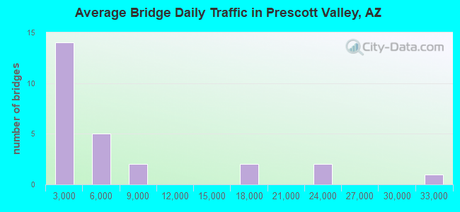
- 164,994Total average daily traffic
- 15,159Total average daily truck traffic
- National Bridge Inventory (NBI) Registered Bridges for Prescott Valley
- No street view available for this location
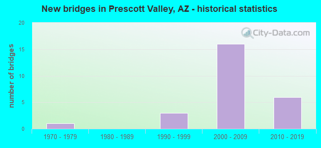
- New bridges - historical statistics
- 11970-1979
- 31990-1999
- 162000-2009
- 62010-2019
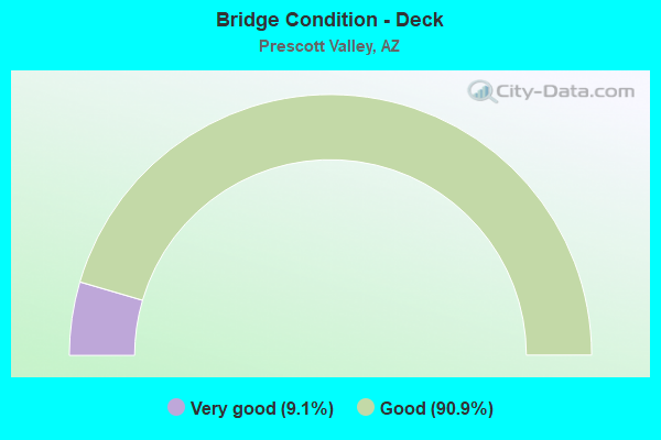
- Bridge Condition - Deck
- 9.1%Very good
- 90.9%Good
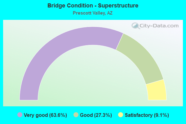
- Bridge Condition - Superstructure
- 63.6%Very good
- 27.3%Good
- 9.1%Satisfactory
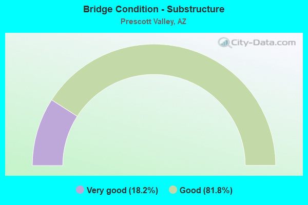
- Bridge Condition - Substructure
- 18.2%Very good
- 81.8%Good
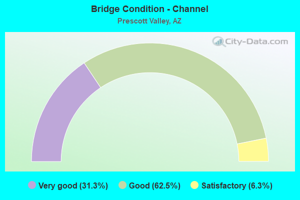
- Bridge Condition - Channel
- 31.3%Very good
- 62.5%Good
- 6.3%Satisfactory

- Bridge Condition - Culverts
- 10.0%Very good
- 90.0%Good
Find on map >> Show street view
Structure Number: 2666, Location: 4.3 mi E Jct SR 89 (Lat: 34.631600, Lng: -112.355500), Route carried "on" structure: Alternate State highway 89, Year Built: 2005, Status: Open, Structure Length: 7.62m (25.00ft), Average Daily Traffic: 16,954 (year 2018), Truck Traffic: 9%, Average Future Daily Traffic: 16,964 (year 2040), Design Load: HS 20, Features Intersected: Glassford Hill Road
Minimum Vertical Clearance: 30+ m (98+ ft), Kilometerpoint: 518.273, Lanes on structure: 2, Lanes under structure: 7, Owner: State Highway Agency, Approaching Roadway Width: 12.8m (42.0ft), Material/Design: Prestressed concrete continuous, Design/Construction: Box Beam or Girders - Single/Spread, Number Of Spans In Main Unit: 2, Length of Maximum Span: 37.5m (123.0ft), Curb-To-Curb Width: 12.8m (42.0ft), Out-to-Out Width: 13.7m (44.9ft)
Condition: Deck: Good, Superstructure: Good, Substructure: Good, Operating Rating: 81.6 metric tons, Method Used To Determine Operating Rating: Load Factor (LF), Inventory Rating: 45.4 metric tons, Method Used To Determine Inventory Rating: Load Factor (LF), Structural Evaluation: Better than present minimum criteria, Deck Geometry: Equal to present desirable criteria, Underclear: Better than present minimum criteria, Approach Roadway Alignment: Equal to present desirable criteria, Designated Inspection Frequency: Every 24 months, Inspection Date: July 2020, Deck Structure Type: Concrete Cast-file-Place, Wearing Surface/Protective System: Wearing Surface: Monolithic Concrete, Deck Protection: Epoxy Coated Reinforcing
Find on map >> Show street view
Structure Number: 2667, Location: 4.3 mi E Jct SR 89 (Lat: 34.631800, Lng: -112.355500), Route carried "on" structure: Alternate State highway 89, Year Built: 2003, Status: Open, Structure Length: 7.62m (25.00ft), Average Daily Traffic: 16,711 (year 2018), Truck Traffic: 9%, Average Future Daily Traffic: 16,721 (year 2040), Design Load: HS 20, Features Intersected: Glassford Hill Road
Minimum Vertical Clearance: 30+ m (98+ ft), Kilometerpoint: 518.273, Lanes on structure: 2, Lanes under structure: 7, Owner: State Highway Agency, Approaching Roadway Width: 12.8m (42.0ft), Material/Design: Prestressed concrete continuous, Design/Construction: Box Beam or Girders - Single/Spread, Number Of Spans In Main Unit: 2, Length of Maximum Span: 37.5m (123.0ft), Curb-To-Curb Width: 12.8m (42.0ft), Out-to-Out Width: 13.7m (44.9ft)
Condition: Deck: Good, Superstructure: Good, Substructure: Good, Operating Rating: 81.6 metric tons, Method Used To Determine Operating Rating: Load Factor (LF), Inventory Rating: 45.4 metric tons, Method Used To Determine Inventory Rating: Load Factor (LF), Structural Evaluation: Better than present minimum criteria, Deck Geometry: Equal to present desirable criteria, Underclear: Better than present minimum criteria, Approach Roadway Alignment: Equal to present desirable criteria, Designated Inspection Frequency: Every 24 months, Inspection Date: July 2020, Deck Structure Type: Concrete Cast-file-Place, Wearing Surface/Protective System: Wearing Surface: Monolithic Concrete, Deck Protection: Epoxy Coated Reinforcing
Find on map >> Show street view
Structure Number: 2959, Location: 5.6 mi E Jct SR 89 (Lat: 34.636600, Lng: -112.334000), Route carried "on" structure: Alternate State highway 89, Year Built: 2011, Status: Open, Structure Length: 6.95m (22.80ft), Average Daily Traffic: 31,986 (year 2018), Truck Traffic: 9%, Average Future Daily Traffic: 31,996 (year 2040), Design Load: HL 93, Features Intersected: SR 89A, Facility Carried by Structure: Viewpoint Drive
Minimum Vertical Clearance: 30+ m (98+ ft), Kilometerpoint: 520.446, Lanes on structure: 4, Lanes under structure: 5, Owner: State Highway Agency, Approaching Roadway Width: 24.4m (80.1ft), Skew: 30 degrees, Material/Design: Prestressed concrete continuous, Design/Construction: Box Beam or Girders - Single/Spread, Number Of Spans In Main Unit: 3, Length of Maximum Span: 31.1m (102.0ft), Curb-To-Curb Width: 36.2m (118.8ft), Out-to-Out Width: 38.1m (125.0ft)
Condition: Deck: Very good, Superstructure: Very good, Substructure: Very good, Operating Rating: 66.2 metric tons, Method Used To Determine Operating Rating: Load Factor (LF), Inventory Rating: 43.5 metric tons, Method Used To Determine Inventory Rating: Load Factor (LF), Structural Evaluation: Equal to present desirable criteria, Deck Geometry: Superior to present desirable criteria, Approach Roadway Alignment: Equal to present desirable criteria, Designated Inspection Frequency: Every 24 months, Inspection Date: July 2020, Deck Structure Type: Concrete Cast-file-Place, Wearing Surface/Protective System: Wearing Surface: Monolithic Concrete, Deck Protection: Epoxy Coated Reinforcing
Find on map >> Show street view
Structure Number: 7174, Location: 10.3 mi E Jct SR 89 (Lat: 34.660300, Lng: -112.258900), Route carried "on" structure: Alternate State highway 89, Year Built: 2008, Status: Open, Structure Length: 2.04m (6.69ft), Average Daily Traffic: 2,335 (year 2018), Truck Traffic: 9%, Average Future Daily Traffic: 2,345 (year 2040), Design Load: HS 20, Features Intersected: Coyote Wash
Minimum Vertical Clearance: 30+ m (98+ ft), Kilometerpoint: 527.994, Lanes on structure: 2, Owner: State Highway Agency, Approaching Roadway Width: 12.2m (40.0ft), Skew: 4 degrees, Material/Design: Concrete continuous, Design/Construction: Culvert, Number Of Spans In Main Unit: 4, Length of Maximum Span: 3.7m (12.1ft)
Condition: Channel: Very good, Culverts: Good, Operating Rating: 89.8 metric tons, Method Used To Determine Operating Rating: Load Factor (LF), Inventory Rating: 89.8 metric tons, Method Used To Determine Inventory Rating: Load Factor (LF), Structural Evaluation: Better than present minimum criteria, Waterway Adequacy: Equal to present desirable criteria, Approach Roadway Alignment: Equal to present desirable criteria, Designated Inspection Frequency: Every 48 months, Inspection Date: July 2020
Find on map >> Show street view
Structure Number: 7301, Location: 2.6 mi N Jct SR69 (Lat: 34.596056, Lng: -112.272028), Route carried "on" structure: Alternate State highway 89, Year Built: 2002, Year Reconstructed: 2012, Status: Open, Structure Length: 0.79m (2.59ft), Average Daily Traffic: 2,335 (year 2018), Truck Traffic: 9%, Average Future Daily Traffic: 2,345 (year 2038), Design Load: HS 20, Features Intersected: Unnamed Wash, Facility Carried by Structure: Fain Road
Minimum Vertical Clearance: 30+ m (98+ ft), Kilometerpoint: 529.587, Lanes on structure: 4, Owner: State Highway Agency, Approaching Roadway Width: 23.2m (76.1ft), Material/Design: Concrete continuous, Design/Construction: Culvert, Number Of Spans In Main Unit: 3, Length of Maximum Span: 2.4m (7.9ft)
Condition: Channel: Very good, Culverts: Good, Operating Rating: 74.4 metric tons, Method Used To Determine Operating Rating: Load Factor (LF), Inventory Rating: 44.5 metric tons, Method Used To Determine Inventory Rating: Load Factor (LF), Structural Evaluation: Better than present minimum criteria, Waterway Adequacy: Equal to present desirable criteria, Approach Roadway Alignment: Equal to present desirable criteria, Designated Inspection Frequency: Every 48 months, Inspection Date: August 2019
Find on map >> Show street view
Structure Number: 7302, Location: 4.8 mi N Jct SR 69 (Lat: 34.628056, Lng: -112.276778), Route carried "on" structure: Alternate State highway 89, Year Built: 2002, Year Reconstructed: 2012, Status: Open, Structure Length: 0.67m (2.20ft), Average Daily Traffic: 2,335 (year 2018), Truck Traffic: 9%, Average Future Daily Traffic: 2,345 (year 2038), Design Load: HS 20, Features Intersected: Unnamed Wash, Facility Carried by Structure: Fain Road
Minimum Vertical Clearance: 30+ m (98+ ft), Kilometerpoint: 526.207, Lanes on structure: 4, Owner: State Highway Agency, Approaching Roadway Width: 12.8m (42.0ft), Skew: 31 degrees, Material/Design: Concrete continuous, Design/Construction: Culvert, Number Of Spans In Main Unit: 2, Length of Maximum Span: 3.0m (9.8ft)
Condition: Channel: Very good, Culverts: Good, Operating Rating: 89.8 metric tons, Method Used To Determine Operating Rating: Load Factor (LF), Inventory Rating: 89.8 metric tons, Method Used To Determine Inventory Rating: Load Factor (LF), Structural Evaluation: Better than present minimum criteria, Waterway Adequacy: Equal to present desirable criteria, Approach Roadway Alignment: Equal to present desirable criteria, Designated Inspection Frequency: Every 48 months, Inspection Date: August 2019
Find on map >> Show street view
Structure Number: 7997, Location: 1.2 mi S of Jct Sr 89A (Lat: 34.615100, Lng: -112.346400), Route carried "on" structure: City street , Year Built: 1996, Status: Open, Structure Length: 0.98m (3.22ft), Average Daily Traffic: 22,277 (year 2020), Truck Traffic: 10%, Average Future Daily Traffic: 22,287 (year 2040), Design Load: HS 20, Features Intersected: Wash, Facility Carried by Structure: Glassford Hill Rd
Minimum Vertical Clearance: 30+ m (98+ ft), Kilometerpoint: 0.000, Lanes on structure: 6, Owner: Town or Township Highway Agency, Approaching Roadway Width: 22.6m (74.1ft), Material/Design: Concrete continuous, Design/Construction: Culvert, Number Of Spans In Main Unit: 3, Length of Maximum Span: 3.0m (9.8ft)
Condition: Channel: Good, Culverts: Good, Operating Rating: 89.8 metric tons, Method Used To Determine Operating Rating: Load Factor (LF), Inventory Rating: 89.8 metric tons, Method Used To Determine Inventory Rating: Load Factor (LF), Structural Evaluation: Better than present minimum criteria, Waterway Adequacy: Equal to present desirable criteria, Approach Roadway Alignment: Equal to present desirable criteria, Length Of Structure Improvement: 1.74m (5.71ft), Designated Inspection Frequency: Every 48 months, Inspection Date: August 2021, Total Project Cost: $1,000 ( Estimate for 2021)
Find on map >> Show street view
Structure Number: 7998, Location: 0.3 mi S of Jct Sr 89A (Lat: 34.627900, Lng: -112.353200), Route carried "on" structure: City street , Year Built: 1996, Status: Open, Structure Length: 0.64m (2.10ft), Average Daily Traffic: 22,203 (year 2020), Truck Traffic: 10%, Average Future Daily Traffic: 22,213 (year 2040), Design Load: HS 20, Features Intersected: Wash, Facility Carried by Structure: Glassford Hill Rd
Minimum Vertical Clearance: 30+ m (98+ ft), Kilometerpoint: 0.000, Lanes on structure: 5, Owner: Town or Township Highway Agency, Approaching Roadway Width: 18.9m (62.0ft), Material/Design: Concrete continuous, Design/Construction: Culvert, Number Of Spans In Main Unit: 2, Length of Maximum Span: 3.0m (9.8ft)
Condition: Channel: Good, Culverts: Very good, Operating Rating: 89.8 metric tons, Method Used To Determine Operating Rating: Load Factor (LF), Inventory Rating: 89.8 metric tons, Method Used To Determine Inventory Rating: Load Factor (LF), Structural Evaluation: Equal to present desirable criteria, Waterway Adequacy: Equal to present desirable criteria, Approach Roadway Alignment: Equal to present desirable criteria, Length Of Structure Improvement: 1.37m (4.49ft), Designated Inspection Frequency: Every 48 months, Inspection Date: August 2021, Total Project Cost: $1,000 ( Estimate for 2021)
Find on map >> Show street view
Structure Number: 10237, Location: 0.4 mi S Jct 69 (Lat: 34.572800, Lng: -112.356800), Route carried "on" structure: City street , Year Built: 2001, Status: Open, Structure Length: 4.39m (14.40ft), Average Daily Traffic: 4,995 (year 2017), Truck Traffic: 5%, Average Future Daily Traffic: 5,005 (year 2037), Design Load: HS 20, Features Intersected: Lynx Creek, Facility Carried by Structure: Stoneridge Drive
Minimum Vertical Clearance: 30+ m (98+ ft), Kilometerpoint: 0.000, Lanes on structure: 2, Owner: Town or Township Highway Agency, Approaching Roadway Width: 17.1m (56.1ft), Material/Design: Prestressed concrete continuous, Design/Construction: Stringer/Multi-beam, Number Of Spans In Main Unit: 2, Length of Maximum Span: 21.3m (69.9ft), Curb or Sidewalk Widths: Left: 3.0m (9.8ft), Right: 0.0m, Curb-To-Curb Width: 17.1m (56.1ft), Out-to-Out Width: 21.2m (69.6ft)
Condition: Deck: Good, Superstructure: Very good, Substructure: Good, Channel: Good, Operating Rating: 63.5 metric tons, Method Used To Determine Operating Rating: Load Factor (LF), Inventory Rating: 32.7 metric tons, Method Used To Determine Inventory Rating: Load Factor (LF), Structural Evaluation: Better than present minimum criteria, Deck Geometry: Superior to present desirable criteria, Waterway Adequacy: Equal to present desirable criteria, Approach Roadway Alignment: Equal to present desirable criteria, Designated Inspection Frequency: Every 24 months, Inspection Date: August 2021, Deck Structure Type: Concrete Cast-file-Place, Wearing Surface/Protective System: Wearing Surface: Monolithic Concrete
Find on map >> Show street view
Structure Number: 10526, Location: 0.3 mi W of Fain Road (Lat: 34.616200, Lng: -112.277700), Route carried "on" structure: City street , Year Built: 2004, Status: Open, Structure Length: 1.52m (4.99ft), Average Daily Traffic: 1,612 (year 2020), Truck Traffic: 5%, Average Future Daily Traffic: 1,622 (year 2040), Design Load: HS 20, Features Intersected: Coyote Drainage Wash, Facility Carried by Structure: Lakeshore Drive
Minimum Vertical Clearance: 30+ m (98+ ft), Kilometerpoint: 0.000, Lanes on structure: 2, Owner: Town or Township Highway Agency, Approaching Roadway Width: 10.4m (34.1ft), Skew: 22 degrees, Material/Design: Concrete continuous, Design/Construction: Culvert, Number Of Spans In Main Unit: 4, Length of Maximum Span: 3.7m (12.1ft)
Condition: Channel: Good, Culverts: Good, Operating Rating: 89.8 metric tons, Method Used To Determine Operating Rating: Load Factor (LF), Inventory Rating: 76.2 metric tons, Method Used To Determine Inventory Rating: Load Factor (LF), Structural Evaluation: Better than present minimum criteria, Waterway Adequacy: Equal to present desirable criteria, Approach Roadway Alignment: Equal to present desirable criteria, Designated Inspection Frequency: Every 48 months, Inspection Date: August 2021
Find on map >> Show street view
Structure Number: 10541, Location: 1.8 mi W of Fain Road (Lat: 34.614800, Lng: -112.284500), Route carried "on" structure: City street , Year Built: 2004, Status: Open, Structure Length: 2.68m (8.79ft), Average Daily Traffic: 1,612 (year 2020), Truck Traffic: 5%, Average Future Daily Traffic: 1,622 (year 2040), Design Load: HS 20, Features Intersected: Agua Fria River, Facility Carried by Structure: Lakeshore Drive
Minimum Vertical Clearance: 30+ m (98+ ft), Kilometerpoint: 0.000, Lanes on structure: 2, Owner: Town or Township Highway Agency, Approaching Roadway Width: 10.4m (34.1ft), Skew: 23 degrees, Material/Design: Concrete continuous, Design/Construction: Culvert, Number Of Spans In Main Unit: 7, Length of Maximum Span: 3.7m (12.1ft)
Condition: Channel: Good, Culverts: Good, Operating Rating: 89.8 metric tons, Method Used To Determine Operating Rating: Load Factor (LF), Inventory Rating: 57.2 metric tons, Method Used To Determine Inventory Rating: Load Factor (LF), Structural Evaluation: Better than present minimum criteria, Waterway Adequacy: Equal to present desirable criteria, Approach Roadway Alignment: Equal to present desirable criteria, Designated Inspection Frequency: Every 48 months, Inspection Date: August 2021
Find on map >> Show street view
Structure Number: 10542, Location: 0.9 mi W of Fain Road (Lat: 34.614600, Lng: -112.287400), Route carried "on" structure: City street , Year Built: 2004, Status: Open, Structure Length: 0.79m (2.59ft), Average Daily Traffic: 2,286 (year 2020), Truck Traffic: 5%, Average Future Daily Traffic: 2,296 (year 2040), Design Load: HS 20, Features Intersected: Drainage Channel, Facility Carried by Structure: Lakeshore Drive
Minimum Vertical Clearance: 30+ m (98+ ft), Kilometerpoint: 0.000, Lanes on structure: 2, Owner: Town or Township Highway Agency, Approaching Roadway Width: 10.4m (34.1ft), Skew: 21 degrees, Material/Design: Concrete continuous, Design/Construction: Culvert, Number Of Spans In Main Unit: 2, Length of Maximum Span: 3.7m (12.1ft)
Condition: Channel: Very good, Culverts: Good, Operating Rating: 89.8 metric tons, Method Used To Determine Operating Rating: Load Factor (LF), Inventory Rating: 89.8 metric tons, Method Used To Determine Inventory Rating: Load Factor (LF), Structural Evaluation: Better than present minimum criteria, Waterway Adequacy: Equal to present desirable criteria, Approach Roadway Alignment: Better than present minimum criteria, Designated Inspection Frequency: Every 48 months, Inspection Date: August 2021
Find on map >> Show street view
Structure Number: 10543, Location: 0.01 mi S of Lakeshore Dr (Lat: 34.612800, Lng: -112.289700), Route carried "on" structure: City street , Year Built: 2004, Status: Open, Structure Length: 1.62m (5.31ft), Average Daily Traffic: 242 (year 2020), Truck Traffic: 5%, Average Future Daily Traffic: 252 (year 2040), Design Load: HS 20, Features Intersected: Drainage Channel, Facility Carried by Structure: Badger Road
Minimum Vertical Clearance: 30+ m (98+ ft), Kilometerpoint: 0.000, Lanes on structure: 2, Owner: Town or Township Highway Agency, Approaching Roadway Width: 7.3m (24.0ft), Material/Design: Concrete continuous, Design/Construction: Culvert, Number Of Spans In Main Unit: 5, Length of Maximum Span: 3.0m (9.8ft), Curb-To-Curb Width: 7.3m (24.0ft), Out-to-Out Width: 20.7m (67.9ft)
Condition: Channel: Very good, Culverts: Good, Operating Rating: 48.1 metric tons, Method Used To Determine Operating Rating: Load Factor (LF), Inventory Rating: 29.0 metric tons, Method Used To Determine Inventory Rating: Load Factor (LF), Structural Evaluation: Better than present minimum criteria, Deck Geometry: Somewhat better than minimum adequacy, Waterway Adequacy: Equal to present desirable criteria, Approach Roadway Alignment: Equal to present desirable criteria, Designated Inspection Frequency: Every 48 months, Inspection Date: August 2021, Deck Structure Type: Concrete Cast-file-Place, Wearing Surface/Protective System: Wearing Surface: Bituminous
Find on map >> Show street view
Structure Number: 10758, Location: 0.05 mi E of Jct SR 69 (Lat: 34.565100, Lng: -112.372600), Route carried "on" structure: County highway , Year Built: 1995, Status: Open, Structure Length: 0.94m (3.08ft), Average Daily Traffic: 510 (year 2019), Truck Traffic: 1%, Average Future Daily Traffic: 520 (year 2039), Design Load: HS 20, Features Intersected: Wash, Facility Carried by Structure: Onyx Dr
Minimum Vertical Clearance: 30+ m (98+ ft), Kilometerpoint: 0.000, Lanes on structure: 2, Owner: County Highway Agency, Approaching Roadway Width: 7.9m (25.9ft), Skew: 3 degrees, Material/Design: Concrete continuous, Design/Construction: Culvert, Number Of Spans In Main Unit: 2, Length of Maximum Span: 4.6m (15.1ft), Curb or Sidewalk Widths: Left: 0.3m (1.0ft), Right: 0.3m (1.0ft), Curb-To-Curb Width: 7.9m (25.9ft), Out-to-Out Width: 8.5m (27.9ft)
Condition: Channel: Good, Culverts: Good, Operating Rating: 62.6 metric tons, Method Used To Determine Operating Rating: Load Factor (LF), Inventory Rating: 37.2 metric tons, Method Used To Determine Inventory Rating: Load Factor (LF), Structural Evaluation: Better than present minimum criteria, Deck Geometry: Somewhat better than minimum adequacy, Waterway Adequacy: Equal to present minimum criteria, Approach Roadway Alignment: Meets minimum limits, Designated Inspection Frequency: Every 48 months, Inspection Date: August 2019, Deck Structure Type: Concrete Cast-file-Place, Wearing Surface/Protective System: Wearing Surface: Bituminous
Find on map >> Show street view
Structure Number: 10761, Location: 0.3 mi from Manzanita Tr. (Lat: 34.556800, Lng: -112.274400), Route carried "on" structure: County highway , Year Built: 1973, Status: Open, Structure Length: 2.41m (7.91ft), Average Daily Traffic: 500 (year 2017), Truck Traffic: 1%, Average Future Daily Traffic: 510 (year 2037), Design Load: HS 20, Features Intersected: Clipper Wash, Facility Carried by Structure: Turquoise Circle
Minimum Vertical Clearance: 30+ m (98+ ft), Kilometerpoint: 0.000, Lanes on structure: 2, Owner: Town or Township Highway Agency, Approaching Roadway Width: 8.5m (27.9ft), Material/Design: Prestressed concrete, Design/Construction: Box Beam or Girders - Multiple, Number Of Spans In Main Unit: 2, Length of Maximum Span: 11.9m (39.0ft), Curb-To-Curb Width: 9.1m (29.9ft), Out-to-Out Width: 10.5m (34.4ft)
Condition: Deck: Good, Superstructure: Satisfactory, Substructure: Good, Channel: Satisfactory, Operating Rating: 56.2 metric tons, Method Used To Determine Operating Rating: Load Factor (LF), Inventory Rating: 32.7 metric tons, Method Used To Determine Inventory Rating: Load Factor (LF), Structural Evaluation: Equal to present minimum criteria, Deck Geometry: Equal to present minimum criteria, Waterway Adequacy: Better than present minimum criteria, Approach Roadway Alignment: Equal to present minimum criteria, Designated Inspection Frequency: Every 24 months, Inspection Date: August 2021, Deck Structure Type: Concrete Cast-file-Place, Wearing Surface/Protective System: Wearing Surface: Bituminous
Find on map >> Show street view
Structure Number: 20079, Location: 4.8 mi N Jct SR 69 (Lat: 34.628400, Lng: -112.277100), Route carried "on" structure: Spur State highway 89, Year Built: 2012, Status: Open, Structure Length: 4.36m (14.30ft), Average Daily Traffic: 6,066 (year 2018), Truck Traffic: 6%, Average Future Daily Traffic: 6,076 (year 2039), Design Load: HL 93, Features Intersected: Coyote Wash
Minimum Vertical Clearance: 30+ m (98+ ft), Kilometerpoint: 525.885, Lanes on structure: 2, Owner: State Highway Agency, Approaching Roadway Width: 11.6m (38.1ft), Skew: 5 degrees, Material/Design: Prestressed concrete, Design/Construction: Stringer/Multi-beam, Number Of Spans In Main Unit: 1, Length of Maximum Span: 40.8m (133.9ft), Curb-To-Curb Width: 12.8m (42.0ft), Out-to-Out Width: 13.7m (44.9ft)
Condition: Deck: Good, Superstructure: Very good, Substructure: Good, Channel: Good, Operating Rating: 89.8 metric tons, Method Used To Determine Operating Rating: Load Factor (LF), Inventory Rating: 35.4 metric tons, Method Used To Determine Inventory Rating: Load Factor (LF), Structural Evaluation: Better than present minimum criteria, Deck Geometry: Equal to present desirable criteria, Waterway Adequacy: Equal to present desirable criteria, Approach Roadway Alignment: Equal to present desirable criteria, Designated Inspection Frequency: Every 24 months, Inspection Date: July 2021, Deck Structure Type: Concrete Cast-file-Place, Wearing Surface/Protective System: Wearing Surface: Monolithic Concrete, Deck Protection: Epoxy Coated Reinforcing
Find on map >> Show street view
Structure Number: 2008, Location: 4.8 mi N Jct SR 69 (Lat: 34.628200, Lng: -112.277200), Route carried "on" structure: Spur State highway 89, Year Built: 2002, Status: Open, Structure Length: 3.84m (12.60ft), Average Daily Traffic: 6,095 (year 2018), Truck Traffic: 6%, Average Future Daily Traffic: 6,105 (year 2039), Design Load: HS 20, Features Intersected: Coyote Wash
Minimum Vertical Clearance: 30+ m (98+ ft), Kilometerpoint: 525.885, Lanes on structure: 2, Owner: State Highway Agency, Approaching Roadway Width: 11.6m (38.1ft), Skew: 2 degrees, Material/Design: Prestressed concrete, Design/Construction: Stringer/Multi-beam, Number Of Spans In Main Unit: 1, Length of Maximum Span: 36.6m (120.1ft), Curb-To-Curb Width: 12.8m (42.0ft), Out-to-Out Width: 13.7m (44.9ft)
Condition: Deck: Good, Superstructure: Very good, Substructure: Good, Channel: Good, Operating Rating: 68.9 metric tons, Method Used To Determine Operating Rating: Load Factor (LF), Inventory Rating: 32.7 metric tons, Method Used To Determine Inventory Rating: Load Factor (LF), Structural Evaluation: Better than present minimum criteria, Deck Geometry: Equal to present desirable criteria, Waterway Adequacy: Equal to present desirable criteria, Approach Roadway Alignment: Equal to present desirable criteria, Designated Inspection Frequency: Every 24 months, Inspection Date: July 2021, Deck Structure Type: Concrete Cast-file-Place, Wearing Surface/Protective System: Wearing Surface: Monolithic Concrete, Deck Protection: Epoxy Coated Reinforcing
Find on map >> Show street view
Structure Number: 20081, Location: 4.0 mi N Jct SR 69 (Lat: 34.616100, Lng: -112.271700), Route carried "on" structure: Spur State highway 89, Year Built: 2012, Status: Open, Structure Length: 3.81m (12.50ft), Average Daily Traffic: 4,301 (year 2018), Truck Traffic: 15%, Average Future Daily Traffic: 4,311 (year 2039), Design Load: HL 93, Features Intersected: Lakeshore Drive
Minimum Vertical Clearance: 30+ m (98+ ft), Kilometerpoint: 527.495, Lanes on structure: 2, Lanes under structure: 2, Owner: State Highway Agency, Approaching Roadway Width: 11.6m (38.1ft), Material/Design: Prestressed concrete, Design/Construction: Stringer/Multi-beam, Number Of Spans In Main Unit: 1, Length of Maximum Span: 36.6m (120.1ft), Curb-To-Curb Width: 12.8m (42.0ft), Out-to-Out Width: 13.7m (44.9ft)
Condition: Deck: Good, Superstructure: Very good, Substructure: Very good, Operating Rating: 89.8 metric tons, Method Used To Determine Operating Rating: Load Factor (LF), Inventory Rating: 36.3 metric tons, Method Used To Determine Inventory Rating: Load Factor (LF), Structural Evaluation: Equal to present desirable criteria, Deck Geometry: Equal to present desirable criteria, Underclear: Better than present minimum criteria, Approach Roadway Alignment: Equal to present desirable criteria, Designated Inspection Frequency: Every 24 months, Inspection Date: July 2021, Deck Structure Type: Concrete Cast-file-Place, Wearing Surface/Protective System: Wearing Surface: Monolithic Concrete, Deck Protection: Epoxy Coated Reinforcing
Find on map >> Show street view
Structure Number: 20082, Location: 4.0 mi N Jct SR 69 (Lat: 34.616000, Lng: -112.272000), Route carried "on" structure: Spur State highway 89, Year Built: 2002, Status: Open, Structure Length: 3.81m (12.50ft), Average Daily Traffic: 4,269 (year 2018), Truck Traffic: 15%, Average Future Daily Traffic: 4,279 (year 2039), Design Load: HS 20, Features Intersected: Lakeshore Drive
Minimum Vertical Clearance: 30+ m (98+ ft), Kilometerpoint: 527.495, Lanes on structure: 2, Lanes under structure: 2, Owner: State Highway Agency, Approaching Roadway Width: 11.6m (38.1ft), Material/Design: Prestressed concrete, Design/Construction: Stringer/Multi-beam, Number Of Spans In Main Unit: 1, Length of Maximum Span: 36.6m (120.1ft), Curb-To-Curb Width: 12.8m (42.0ft), Out-to-Out Width: 13.7m (44.9ft)
Condition: Deck: Good, Superstructure: Very good, Substructure: Good, Operating Rating: 68.9 metric tons, Method Used To Determine Operating Rating: Load Factor (LF), Inventory Rating: 32.7 metric tons, Method Used To Determine Inventory Rating: Load Factor (LF), Structural Evaluation: Better than present minimum criteria, Deck Geometry: Equal to present desirable criteria, Underclear: Better than present minimum criteria, Approach Roadway Alignment: Equal to present desirable criteria, Designated Inspection Frequency: Every 24 months, Inspection Date: July 2021, Deck Structure Type: Concrete Cast-file-Place, Wearing Surface/Protective System: Wearing Surface: Monolithic Concrete, Deck Protection: Epoxy Coated Reinforcing
Find on map >> Show street view
Structure Number: 20083, Location: 1.5 mi N Jct SR 69 (Lat: 34.579800, Lng: -112.266100), Route carried "on" structure: Spur State highway 89, Year Built: 2012, Status: Open, Structure Length: 3.87m (12.70ft), Average Daily Traffic: 4,301 (year 2018), Truck Traffic: 15%, Average Future Daily Traffic: 4,311 (year 2039), Design Load: HL 93, Features Intersected: Agua Fria River
Minimum Vertical Clearance: 30+ m (98+ ft), Kilometerpoint: 531.518, Lanes on structure: 2, Owner: State Highway Agency, Approaching Roadway Width: 11.6m (38.1ft), Skew: 3 degrees, Material/Design: Prestressed concrete, Design/Construction: Stringer/Multi-beam, Number Of Spans In Main Unit: 1, Length of Maximum Span: 36.6m (120.1ft), Curb-To-Curb Width: 12.8m (42.0ft), Out-to-Out Width: 13.7m (44.9ft)
Condition: Deck: Good, Superstructure: Very good, Substructure: Good, Channel: Good, Operating Rating: 89.8 metric tons, Method Used To Determine Operating Rating: Load Factor (LF), Inventory Rating: 33.6 metric tons, Method Used To Determine Inventory Rating: Load Factor (LF), Structural Evaluation: Better than present minimum criteria, Deck Geometry: Equal to present desirable criteria, Waterway Adequacy: Equal to present desirable criteria, Approach Roadway Alignment: Equal to present desirable criteria, Designated Inspection Frequency: Every 24 months, Inspection Date: July 2021, Deck Structure Type: Concrete Cast-file-Place, Wearing Surface/Protective System: Wearing Surface: Monolithic Concrete, Deck Protection: Epoxy Coated Reinforcing
Find on map >> Show street view
Structure Number: 20084, Location: 1.5 mi N Jct SR 69 (Lat: 34.580000, Lng: -112.266300), Route carried "on" structure: Spur State highway 89, Year Built: 2002, Status: Open, Structure Length: 3.23m (10.60ft), Average Daily Traffic: 4,269 (year 2018), Truck Traffic: 15%, Average Future Daily Traffic: 4,279 (year 2039), Design Load: HS 20, Features Intersected: Agua Fria River
Minimum Vertical Clearance: 30+ m (98+ ft), Kilometerpoint: 531.518, Lanes on structure: 2, Owner: State Highway Agency, Approaching Roadway Width: 11.6m (38.1ft), Skew: 3 degrees, Material/Design: Prestressed concrete, Design/Construction: Stringer/Multi-beam, Number Of Spans In Main Unit: 1, Length of Maximum Span: 30.5m (100.1ft), Curb-To-Curb Width: 12.8m (42.0ft), Out-to-Out Width: 13.7m (44.9ft)
Condition: Deck: Good, Superstructure: Good, Substructure: Good, Channel: Good, Operating Rating: 76.2 metric tons, Method Used To Determine Operating Rating: Load Factor (LF), Inventory Rating: 39.9 metric tons, Method Used To Determine Inventory Rating: Load Factor (LF), Structural Evaluation: Better than present minimum criteria, Deck Geometry: Equal to present desirable criteria, Waterway Adequacy: Equal to present desirable criteria, Approach Roadway Alignment: Equal to present desirable criteria, Designated Inspection Frequency: Every 24 months, Inspection Date: July 2021, Deck Structure Type: Concrete Cast-file-Place, Wearing Surface/Protective System: Wearing Surface: Monolithic Concrete, Deck Protection: Epoxy Coated Reinforcing
Find on map >> Show street view
Structure Number: 2666, Location: 4.3 mi E Jct SR 89 (Lat: 34.631600, Lng: -112.355500), Route carried "under" structure: City street , Year Built: 2005, Structure Length: 0. m, Average Daily Traffic: 2,000 (year 2020), Truck Traffic: 5%, Features Intersected: Glassford Hill Road, Facility Carried by Structure: SR 89A
Minimum Vertical Clearance: 6.20m (20.34ft), Kilometerpoint: 0.000, Lanes on structure: 2, Lanes under structure: 7, Material/Design: Prestressed concrete continuous, Design/Construction: Box Beam or Girders - Single/Spread, Length of Maximum Span: 37.5m (123.0ft)
Find on map >> Show street view
Structure Number: 2667, Location: 4.3 mi E Jct SR 89 (Lat: 34.631800, Lng: -112.355500), Route carried "under" structure: City street , Year Built: 2003, Structure Length: 0. m, Average Daily Traffic: 2,000 (year 2020), Truck Traffic: 5%, Features Intersected: Glassford Hill Road, Facility Carried by Structure: SR 89A
Minimum Vertical Clearance: 5.85m (19.19ft), Kilometerpoint: 0.000, Lanes on structure: 2, Lanes under structure: 7, Material/Design: Prestressed concrete continuous, Design/Construction: Box Beam or Girders - Single/Spread, Length of Maximum Span: 37.5m (123.0ft)
Find on map >> Show street view
Structure Number: 2959, Location: 5.6 mi E Jct SR 89 (Lat: 34.636600, Lng: -112.334000), Route carried "under" structure: City street , Year Built: 2011, Structure Length: 0. m, Average Daily Traffic: 2,500 (year 2020), Truck Traffic: 5%, Features Intersected: SR 89A, Facility Carried by Structure: Viewpoint Drive
Minimum Vertical Clearance: 6.35m (20.83ft), Kilometerpoint: 0.000, Lanes on structure: 4, Lanes under structure: 5, Material/Design: Prestressed concrete continuous, Design/Construction: Box Beam or Girders - Single/Spread, Length of Maximum Span: 31.1m (102.0ft)
Find on map >> Show street view
Structure Number: 20081, Location: 4.0 mi N Jct SR 69 (Lat: 34.616100, Lng: -112.271700), Route carried "under" structure: County highway , Year Built: 2012, Structure Length: 0. m, Average Daily Traffic: 150 (year 2017), Truck Traffic: 1%, Features Intersected: Lakeshore Drive, Facility Carried by Structure: SR 89A Spur NB
Minimum Vertical Clearance: 5.10m (16.73ft), Kilometerpoint: 0.000, Lanes on structure: 2, Lanes under structure: 2, Material/Design: Prestressed concrete, Design/Construction: Stringer/Multi-beam, Length of Maximum Span: 36.6m (120.1ft)
Find on map >> Show street view
Structure Number: 20082, Location: 4.0 mi N Jct SR 69 (Lat: 34.616000, Lng: -112.272000), Route carried "under" structure: County highway , Year Built: 2002, Structure Length: 0. m, Average Daily Traffic: 150 (year 2017), Truck Traffic: 5%, Features Intersected: Lakeshore Drive, Facility Carried by Structure: SR 89A Spur SB
Minimum Vertical Clearance: 5.25m (17.22ft), Kilometerpoint: 0.000, Lanes on structure: 2, Lanes under structure: 2, Material/Design: Prestressed concrete, Design/Construction: Stringer/Multi-beam, Length of Maximum Span: 36.6m (120.1ft)