Bridge Statistics for Powellton, West Virginia (WV)
Condition, Traffic, Stress, Structural Evaluation, Project Costs
- National Bridge Inventory (NBI) Statistics
- 37Number of bridges
- 367ft / 112mTotal length
- $3,662,000Total costs
- 283,196Total average daily traffic
- 48,830Total average daily truck traffic
- National Bridge Inventory (NBI) Registered Bridges for Powellton
- No street view available for this location
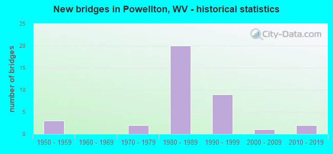
- New bridges - historical statistics
- 31950-1959
- 21970-1979
- 201980-1989
- 91990-1999
- 12000-2009
- 22010-2019


- Bridge Condition - Deck
- 3.7%Very good
- 29.6%Good
- 37.0%Satisfactory
- 22.2%Fair
- 7.4%Poor

- Bridge Condition - Superstructure
- 3.6%Very good
- 39.3%Good
- 39.3%Satisfactory
- 14.3%Fair
- 3.6%Poor

- Bridge Condition - Substructure
- 7.1%Very good
- 42.9%Good
- 32.1%Satisfactory
- 14.3%Fair
- 3.6%Poor

- Bridge Condition - Channel
- 32.0%Very good
- 28.0%Good
- 20.0%Satisfactory
- 12.0%Fair
- 4.0%Poor
- 4.0%Serious
Find on map >> Show street view
Structure Number: 10A021, Location: 0.01 Miles N. of CR 6/7 (Lat: 38.080319, Lng: -81.333589), Route carried "on" structure: County highway 601, Year Built: 1977, Status: Open, Structure Length: 1.57m (5.15ft), Average Daily Traffic: 1,070 (year 2020), Truck Traffic: 6%, Average Future Daily Traffic: 1,305 (year 2040), Design Load: HS 20, Features Intersected: ARMSTRONG CREEK, Facility Carried by Structure: COUNTY ROUTE 6/1
Minimum Vertical Clearance: 30+ m (98+ ft), Kilometerpoint: 2.462, Lanes on structure: 2, Owner: State Highway Agency, Approaching Roadway Width: 7.3m (24.0ft), Skew: 4 degrees, Material/Design: Aluminum, Iron, Design/Construction: Arch - Deck, Number Of Spans In Main Unit: 1, Length of Maximum Span: 11.3m (37.1ft), Curb-To-Curb Width: 6.3m (20.7ft), Out-to-Out Width: 6.9m (22.6ft)
Condition: Superstructure: Satisfactory, Substructure: Satisfactory, Channel: Satisfactory, Operating Rating: 59.0 metric tons, Method Used To Determine Operating Rating: Field evaluation and documented engineering judgment, Inventory Rating: 24.5 metric tons, Method Used To Determine Inventory Rating: Field evaluation and documented engineering judgment, Structural Evaluation: Equal to present minimum criteria, Deck Geometry: High priority of replacement, Waterway Adequacy: Superior to present desirable criteria, Approach Roadway Alignment: High priority of corrective action, Length Of Structure Improvement: 1.83m (6.00ft), Designated Inspection Frequency: Every 24 months, Inspection Date: June 2021, Bridge Improvement Cost: $513,000, Roadway Improvement Cost: $335,000, Total Project Cost: $848,000 ( Estimate for 2021)
Find on map >> Show street view
Structure Number: 10A05, Location: 0.40 Miles S. of CR 15/21 (Lat: 38.018569, Lng: -81.352819), Route carried "on" structure: County highway 1500, Year Built: 1988, Status: Posted for load, Structure Length: 3.40m (11.15ft), Average Daily Traffic: 43 (year 2020), Truck Traffic: 6%, Average Future Daily Traffic: 52 (year 2040), Design Load: HS 20, Features Intersected: PAINT CREEK, Facility Carried by Structure: COUNTY ROUTE 15
Minimum Vertical Clearance: 30+ m (98+ ft), Kilometerpoint: 25.910, Lanes on structure: 1, Owner: State Highway Agency, Approaching Roadway Width: 4.9m (16.1ft), Material/Design: Steel continuous, Design/Construction: Girder and Floorbeam System, Number Of Spans In Main Unit: 1, Number Of Approach Spans: 4, Length of Maximum Span: 11.1m (36.4ft), Curb-To-Curb Width: 4.8m (15.7ft), Out-to-Out Width: 4.9m (16.1ft)
Condition: Deck: Poor, Superstructure: Fair, Substructure: Poor, Channel: Fair, Operating Rating: 21.8 metric tons, Method Used To Determine Operating Rating: Load Factor (LF), Inventory Rating: 13.6 metric tons, Method Used To Determine Inventory Rating: Load Factor (LF), Structural Evaluation: Meets minimum limits, Deck Geometry: Equal to present desirable criteria, Waterway Adequacy: Equal to present desirable criteria, Approach Roadway Alignment: Better than present minimum criteria, Length Of Structure Improvement: 4.57m (14.99ft), Designated Inspection Frequency: Every 24 months, Critical Feature Inspection Frequency: Every 24 months, Underwater Inspection Frequency: Every 60 months, Other Special Inspection Frequency: Every 12 months, Inspection Date: December 2021, Critical Feature Inspection Date: December 2021, Underwater Inspection Date: June 2020, Other Special Inspection Date: December 2021, Bridge Improvement Cost: $590,000, Roadway Improvement Cost: $346,000, Total Project Cost: $936,000 ( Estimate for 2022), Deck Structure Type: Wood or Timber, Wearing Surface/Protective System: Deck Protection: Other
Find on map >> Show street view
Structure Number: 10A052, Location: 0.26 Miles S. of CR 15/21 (Lat: 38.021061, Lng: -81.354939), Route carried "on" structure: County highway 1500, Year Built: 1992, Status: Open, Structure Length: 2.86m (9.38ft), Average Daily Traffic: 40 (year 2019), Truck Traffic: 6%, Average Future Daily Traffic: 49 (year 2039), Design Load: HS 25 or greater, Features Intersected: PAINT CREEK, Facility Carried by Structure: COUNTY ROUTE 15
Minimum Vertical Clearance: 30+ m (98+ ft), Kilometerpoint: 26.297, Lanes on structure: 2, Owner: State Highway Agency, Approaching Roadway Width: 4.3m (14.1ft), Skew: 2 degrees, Material/Design: Prestressed concrete, Design/Construction: Box Beam or Girders - Multiple, Number Of Spans In Main Unit: 1, Length of Maximum Span: 27.4m (89.9ft), Curb-To-Curb Width: 7.8m (25.6ft), Out-to-Out Width: 8.2m (26.9ft)
Condition: Deck: Satisfactory, Superstructure: Satisfactory, Substructure: Good, Channel: Satisfactory, Operating Rating: 88.9 metric tons, Method Used To Determine Operating Rating: Load Factor (LF), Inventory Rating: 75.3 metric tons, Method Used To Determine Inventory Rating: Load Factor (LF), Structural Evaluation: Equal to present minimum criteria, Deck Geometry: Equal to present minimum criteria, Waterway Adequacy: Superior to present desirable criteria, Approach Roadway Alignment: Equal to present desirable criteria, Designated Inspection Frequency: Every 24 months, Inspection Date: July 2021, Deck Structure Type: Other, Wearing Surface/Protective System: Wearing Surface: Bituminous, Deck Protection: Epoxy Coated Reinforcing
Find on map >> Show street view
Structure Number: 10A053, Location: 0.12 Miles N. of CR 15/22 (Lat: 38.039689, Lng: -81.363550), Route carried "on" structure: County highway 1500, Year Built: 1991, Status: Open, Structure Length: 5.40m (17.72ft), Average Daily Traffic: 44 (year 2019), Truck Traffic: 6%, Average Future Daily Traffic: 54 (year 2039), Design Load: HS 25 or greater, Features Intersected: PAINT CREEK, Facility Carried by Structure: COUNTY ROUTE 15
Minimum Vertical Clearance: 30+ m (98+ ft), Kilometerpoint: 28.566, Lanes on structure: 2, Owner: State Highway Agency, Approaching Roadway Width: 7.3m (24.0ft), Skew: 3 degrees, Material/Design: Prestressed concrete, Design/Construction: Box Beam or Girders - Multiple, Number Of Spans In Main Unit: 1, Number Of Approach Spans: 2, Length of Maximum Span: 21.3m (69.9ft), Curb-To-Curb Width: 7.8m (25.6ft), Out-to-Out Width: 8.3m (27.2ft)
Condition: Deck: Fair, Superstructure: Fair, Substructure: Fair, Channel: Good, Operating Rating: 88.9 metric tons, Method Used To Determine Operating Rating: Load Factor (LF), Inventory Rating: 56.2 metric tons, Method Used To Determine Inventory Rating: Load Factor (LF), Structural Evaluation: Somewhat better than minimum adequacy, Deck Geometry: Equal to present minimum criteria, Waterway Adequacy: Superior to present desirable criteria, Approach Roadway Alignment: Equal to present minimum criteria, Designated Inspection Frequency: Every 24 months, Inspection Date: June 2021, Deck Structure Type: Other, Wearing Surface/Protective System: Wearing Surface: Bituminous, Deck Protection: Epoxy Coated Reinforcing
Find on map >> Show street view
Structure Number: 10A173, Location: 0.99 Miles S. of WV 61 (Lat: 38.166039, Lng: -81.330869), Route carried "on" structure: County highway 6109, Year Built: 1989, Status: Open, Structure Length: 2.18m (7.15ft), Average Daily Traffic: 199 (year 2019), Truck Traffic: 6%, Average Future Daily Traffic: 243 (year 2039), Design Load: HS 25 or greater, Features Intersected: MORRIS CREEK, Facility Carried by Structure: CR 61/9
Minimum Vertical Clearance: 30+ m (98+ ft), Kilometerpoint: 0.805, Lanes on structure: 2, Owner: State Highway Agency, Approaching Roadway Width: 6.7m (22.0ft), Skew: 3 degrees, Material/Design: Prestressed concrete, Design/Construction: Box Beam or Girders - Multiple, Number Of Spans In Main Unit: 1, Length of Maximum Span: 21.3m (69.9ft), Curb-To-Curb Width: 8.0m (26.2ft), Out-to-Out Width: 8.3m (27.2ft)
Condition: Deck: Satisfactory, Superstructure: Satisfactory, Substructure: Good, Channel: Very good, Operating Rating: 88.9 metric tons, Method Used To Determine Operating Rating: Load Factor (LF), Inventory Rating: 61.7 metric tons, Method Used To Determine Inventory Rating: Load Factor (LF), Structural Evaluation: Equal to present minimum criteria, Deck Geometry: Somewhat better than minimum adequacy, Waterway Adequacy: Superior to present desirable criteria, Approach Roadway Alignment: Equal to present desirable criteria, Designated Inspection Frequency: Every 24 months, Inspection Date: March 2021, Deck Structure Type: Other, Wearing Surface/Protective System: Wearing Surface: Bituminous, Deck Protection: Epoxy Coated Reinforcing
Find on map >> Show street view
Structure Number: 10A179, Location: 0.01 Miles N. of CR 61/50 (Lat: 38.106100, Lng: -81.322011), Route carried "on" structure: County highway 6124, Year Built: 1993, Status: Open, Structure Length: 1.20m (3.94ft), Average Daily Traffic: 1,793 (year 2020), Truck Traffic: 6%, Average Future Daily Traffic: 2,187 (year 2040), Design Load: HS 25 or greater, Features Intersected: JENKINS FORK, Facility Carried by Structure: COUNTY ROUTE 61/24
Minimum Vertical Clearance: 30+ m (98+ ft), Kilometerpoint: 5.279, Lanes on structure: 2, Owner: State Highway Agency, Approaching Roadway Width: 7.9m (25.9ft), Material/Design: Prestressed concrete, Design/Construction: Box Beam or Girders - Multiple, Number Of Spans In Main Unit: 1, Length of Maximum Span: 11.6m (38.1ft), Curb-To-Curb Width: 9.7m (31.8ft), Out-to-Out Width: 10.1m (33.1ft)
Condition: Deck: Good, Superstructure: Good, Substructure: Good, Channel: Poor, Operating Rating: 64.4 metric tons, Method Used To Determine Operating Rating: Load Factor (LF), Inventory Rating: 39.0 metric tons, Method Used To Determine Inventory Rating: Load Factor (LF), Structural Evaluation: Better than present minimum criteria, Deck Geometry: Somewhat better than minimum adequacy, Waterway Adequacy: Equal to present desirable criteria, Approach Roadway Alignment: Equal to present desirable criteria, Designated Inspection Frequency: Every 24 months, Inspection Date: May 2021, Deck Structure Type: Other, Wearing Surface/Protective System: Wearing Surface: Bituminous, Deck Protection: Epoxy Coated Reinforcing
Find on map >> Show street view
Structure Number: 10A18, Location: 0.01 Miles N. of CR 6/1 (Lat: 38.099431, Lng: -81.323600), Route carried "on" structure: County highway 6124, Year Built: 1976, Status: Posted for load, Structure Length: 1.26m (4.13ft), Average Daily Traffic: 1,800 (year 2020), Truck Traffic: 6%, Average Future Daily Traffic: 2,196 (year 2040), Design Load: HS 20, Features Intersected: ARMSTRONG CREEK, Facility Carried by Structure: COUNTY ROUTE 61/24
Minimum Vertical Clearance: 30+ m (98+ ft), Kilometerpoint: 6.067, Lanes on structure: 2, Owner: State Highway Agency, Approaching Roadway Width: 6.1m (20.0ft), Skew: 1 degrees, Material/Design: Prestressed concrete, Design/Construction: Channel Beam, Number Of Spans In Main Unit: 1, Length of Maximum Span: 12.2m (40.0ft), Curb-To-Curb Width: 7.7m (25.3ft), Out-to-Out Width: 8.2m (26.9ft)
Condition: Deck: Poor, Superstructure: Poor, Substructure: Satisfactory, Channel: Good, Operating Rating: 46.3 metric tons, Method Used To Determine Operating Rating: Load Factor (LF), Inventory Rating: 28.1 metric tons, Method Used To Determine Inventory Rating: Load Factor (LF), Structural Evaluation: Meets minimum limits, Deck Geometry: Meets minimum limits, Waterway Adequacy: Equal to present desirable criteria, Approach Roadway Alignment: Equal to present desirable criteria, Length Of Structure Improvement: 1.83m (6.00ft), Designated Inspection Frequency: Every 24 months, Other Special Inspection Frequency: Every 6 months, Inspection Date: June 2021, Other Special Inspection Date: December 2021, Bridge Improvement Cost: $505,000, Roadway Improvement Cost: $327,000, Total Project Cost: $832,000 ( Estimate for 2022), Deck Structure Type: Other, Wearing Surface/Protective System: Wearing Surface: Bituminous
Find on map >> Show street view
Structure Number: 10A181, Location: 0.31 Miles S. of CR 6/1 (Lat: 38.095511, Lng: -81.320661), Route carried "on" structure: County highway 6124, Year Built: 1989, Status: Open, Structure Length: 1.43m (4.69ft), Average Daily Traffic: 1,045 (year 2019), Truck Traffic: 6%, Average Future Daily Traffic: 1,275 (year 2039), Design Load: HS 25 or greater, Features Intersected: POWELLTON FORK, Facility Carried by Structure: COUNTY ROUTE 61/24
Minimum Vertical Clearance: 30+ m (98+ ft), Kilometerpoint: 6.582, Lanes on structure: 2, Owner: State Highway Agency, Approaching Roadway Width: 6.1m (20.0ft), Skew: 3 degrees, Material/Design: Steel, Design/Construction: Stringer/Multi-beam, Number Of Spans In Main Unit: 1, Length of Maximum Span: 12.8m (42.0ft), Curb-To-Curb Width: 8.0m (26.2ft), Out-to-Out Width: 8.8m (28.9ft)
Condition: Deck: Good, Superstructure: Good, Substructure: Good, Channel: Very good, Operating Rating: 88.9 metric tons, Method Used To Determine Operating Rating: Load Factor (LF), Inventory Rating: 62.6 metric tons, Method Used To Determine Inventory Rating: Load Factor (LF), Structural Evaluation: Better than present minimum criteria, Deck Geometry: Meets minimum limits, Waterway Adequacy: Equal to present minimum criteria, Approach Roadway Alignment: Equal to present desirable criteria, Length Of Structure Improvement: 1.43m (4.69ft), Designated Inspection Frequency: Every 24 months, Inspection Date: April 2021, Bridge Improvement Cost: $195,000, Roadway Improvement Cost: $193,000, Total Project Cost: $456,000 ( Estimate for 2021), Deck Structure Type: Concrete Cast-file-Place, Wearing Surface/Protective System: Wearing Surface: Monolithic Concrete, Deck Protection: Epoxy Coated Reinforcing
Find on map >> Show street view
Structure Number: 10A182, Location: 0.01 Miles S. of CR 61/52 (Lat: 38.086850, Lng: -81.312581), Route carried "on" structure: County highway 6124, Year Built: 1989, Status: Open, Structure Length: 2.01m (6.59ft), Average Daily Traffic: 550 (year 2019), Truck Traffic: 6%, Average Future Daily Traffic: 671 (year 2039), Design Load: HS 25 or greater, Features Intersected: POWELLTON FORK, Facility Carried by Structure: COUNTY ROUTE 61/24
Minimum Vertical Clearance: 30+ m (98+ ft), Kilometerpoint: 7.129, Lanes on structure: 2, Owner: State Highway Agency, Approaching Roadway Width: 7.6m (24.9ft), Skew: 5 degrees, Material/Design: Steel, Design/Construction: Stringer/Multi-beam, Number Of Spans In Main Unit: 1, Length of Maximum Span: 18.3m (60.0ft), Curb-To-Curb Width: 7.6m (24.9ft), Out-to-Out Width: 8.7m (28.5ft)
Condition: Deck: Good, Superstructure: Good, Substructure: Good, Channel: Good, Operating Rating: 88.9 metric tons, Method Used To Determine Operating Rating: Load Factor (LF), Inventory Rating: 61.7 metric tons, Method Used To Determine Inventory Rating: Load Factor (LF), Structural Evaluation: Better than present minimum criteria, Deck Geometry: Meets minimum limits, Waterway Adequacy: Superior to present desirable criteria, Approach Roadway Alignment: Equal to present desirable criteria, Designated Inspection Frequency: Every 24 months, Inspection Date: August 2021, Deck Structure Type: Concrete Cast-file-Place, Wearing Surface/Protective System: Wearing Surface: Latex Concrete, Deck Protection: Epoxy Coated Reinforcing
Find on map >> Show street view
Structure Number: 10A183, Location: 0.42 Miles S. of CR 61/52 (Lat: 38.086861, Lng: -81.312561), Route carried "on" structure: County highway 6124, Year Built: 1989, Status: Open, Structure Length: 1.51m (4.95ft), Average Daily Traffic: 1,111 (year 2019), Truck Traffic: 6%, Average Future Daily Traffic: 1,355 (year 2039), Design Load: HS 25 or greater, Features Intersected: POWELLTON FORK, Facility Carried by Structure: COUNTY ROUTE 61/24
Minimum Vertical Clearance: 30+ m (98+ ft), Kilometerpoint: 7.789, Lanes on structure: 2, Owner: State Highway Agency, Approaching Roadway Width: 6.1m (20.0ft), Skew: 3 degrees, Material/Design: Prestressed concrete, Design/Construction: Box Beam or Girders - Multiple, Number Of Spans In Main Unit: 1, Length of Maximum Span: 14.6m (47.9ft), Curb or Sidewalk Widths: Left: 0.2m (0.7ft), Right: 0.2m (0.7ft), Curb-To-Curb Width: 7.7m (25.3ft), Out-to-Out Width: 8.3m (27.2ft)
Condition: Deck: Good, Superstructure: Good, Substructure: Satisfactory, Channel: Satisfactory, Operating Rating: 88.9 metric tons, Method Used To Determine Operating Rating: Load Factor (LF), Inventory Rating: 58.0 metric tons, Method Used To Determine Inventory Rating: Load Factor (LF), Structural Evaluation: Equal to present minimum criteria, Deck Geometry: Meets minimum limits, Waterway Adequacy: Superior to present desirable criteria, Approach Roadway Alignment: Equal to present desirable criteria, Designated Inspection Frequency: Every 24 months, Inspection Date: May 2021, Deck Structure Type: Other, Wearing Surface/Protective System: Wearing Surface: Bituminous, Deck Protection: Epoxy Coated Reinforcing
Find on map >> Show street view
Structure Number: 10A184, Location: 0.01 Miles S. of CR 15 (Lat: 38.024889, Lng: -81.354700), Route carried "on" structure: County highway 1521, Year Built: 1956, Year Reconstructed: 1987, Status: Posted for load, Structure Length: 2.59m (8.50ft), Average Daily Traffic: 10 (year 2020), Truck Traffic: 6%, Average Future Daily Traffic: 12 (year 2040), Design Load: H 20, Features Intersected: PAINT CREEK, Facility Carried by Structure: COUNTY ROUTE 15/21
Minimum Vertical Clearance: 30+ m (98+ ft), Kilometerpoint: 0.016, Lanes on structure: 1, Owner: State Highway Agency, Approaching Roadway Width: 3.0m (9.8ft), Material/Design: Steel, Design/Construction: Stringer/Multi-beam, Number Of Spans In Main Unit: 1, Number Of Approach Spans: 1, Length of Maximum Span: 12.3m (40.4ft), Curb-To-Curb Width: 4.1m (13.5ft), Out-to-Out Width: 4.3m (14.1ft)
Condition: Deck: Satisfactory, Superstructure: Fair, Substructure: Fair, Channel: Fair, Operating Rating: 44.4 metric tons, Method Used To Determine Operating Rating: Load Factor (LF), Inventory Rating: 27.2 metric tons, Method Used To Determine Inventory Rating: Load Factor (LF), Structural Evaluation: Somewhat better than minimum adequacy, Deck Geometry: Somewhat better than minimum adequacy, Waterway Adequacy: Superior to present desirable criteria, Approach Roadway Alignment: Equal to present minimum criteria, Designated Inspection Frequency: Every 24 months, Inspection Date: August 2021, Deck Structure Type: Wood or Timber, Wearing Surface/Protective System: Deck Protection: Other
Find on map >> Show street view
Structure Number: 10A224, Location: 2.7 MI S OF CR 15 I/C (Lat: 38.020469, Lng: -81.354339), Route carried "on" structure: Interstate 7700, Year Built: 1981, Status: Open, Structure Length: 14.24m (46.72ft), Average Daily Traffic: 27,683 (year 2018), Truck Traffic: 18%, Average Future Daily Traffic: 33,773 (year 2038), Design Load: HS 20+Mod, Features Intersected: Route 15 and Paint Creek, Facility Carried by Structure: I-77
Minimum Vertical Clearance: 30+ m (98+ ft), Kilometerpoint: 105.332, Lanes on structure: 4, Lanes under structure: 2, Base Highway Network: Yes, Toll: On Interstate toll segment, Owner: State Toll Authority, Approaching Roadway Width: 25.0m (82.0ft), Skew: 33 degrees, Material/Design: Steel continuous, Design/Construction: Stringer/Multi-beam, Number Of Spans In Main Unit: 1, Number Of Approach Spans: 3, Length of Maximum Span: 46.6m (152.9ft), Curb-To-Curb Width: 25.8m (84.6ft), Out-to-Out Width: 27.6m (90.6ft)
Condition: Deck: Fair, Superstructure: Satisfactory, Substructure: Satisfactory, Channel: Very good, Operating Rating: 68.9 metric tons, Method Used To Determine Operating Rating: Load Factor (LF), Inventory Rating: 40.8 metric tons, Method Used To Determine Inventory Rating: Load Factor (LF), Structural Evaluation: Equal to present minimum criteria, Deck Geometry: Superior to present desirable criteria, Underclear: Superior to present desirable criteria, Waterway Adequacy: Superior to present desirable criteria, Approach Roadway Alignment: Equal to present desirable criteria, Designated Inspection Frequency: Every 24 months, Other Special Inspection Frequency: Every 12 months, Inspection Date: December 2020, Other Special Inspection Date: December 2021, Deck Structure Type: Concrete Cast-file-Place, Wearing Surface/Protective System: Wearing Surface: Monolithic Concrete, Deck Protection: Epoxy Coated Reinforcing
Find on map >> Show street view
Structure Number: 10A232, Location: 0.00 MI N OF CR 15 (Lat: 38.029281, Lng: -81.357461), Route carried "on" structure: Ramp County highway 1520, Year Built: 1981, Status: Open, Structure Length: 6.41m (21.03ft), Average Daily Traffic: 132 (year 2018), Truck Traffic: 18%, Average Future Daily Traffic: 130 (year 2038), Design Load: HS 20+Mod, Features Intersected: I-77, Facility Carried by Structure: I77 CONNECTOR
Minimum Vertical Clearance: 30+ m (98+ ft), Kilometerpoint: 0.064, Lanes on structure: 2, Lanes under structure: 4, Toll: On Interstate toll segment, Owner: State Toll Authority, Approaching Roadway Width: 12.2m (40.0ft), Skew: 2 degrees, Material/Design: Steel continuous, Design/Construction: Stringer/Multi-beam, Number Of Spans In Main Unit: 1, Number Of Approach Spans: 1, Length of Maximum Span: 33.8m (110.9ft), Curb-To-Curb Width: 13.1m (43.0ft), Out-to-Out Width: 14.2m (46.6ft)
Condition: Deck: Satisfactory, Superstructure: Good, Substructure: Satisfactory, Operating Rating: 78.9 metric tons, Method Used To Determine Operating Rating: Load Factor (LF), Inventory Rating: 47.2 metric tons, Method Used To Determine Inventory Rating: Load Factor (LF), Structural Evaluation: Equal to present minimum criteria, Deck Geometry: Superior to present desirable criteria, Underclear: Somewhat better than minimum adequacy, Approach Roadway Alignment: Equal to present desirable criteria, Designated Inspection Frequency: Every 24 months, Inspection Date: October 2020, Deck Structure Type: Concrete Cast-file-Place, Wearing Surface/Protective System: Wearing Surface: Monolithic Concrete, Deck Protection: Epoxy Coated Reinforcing
Find on map >> Show street view
Structure Number: 10A239, Location: 0.12 Miles S. of CR 61/43 (Lat: 38.135889, Lng: -81.302889), Route carried "on" structure: County highway 6124, Year Built: 1993, Status: Open, Structure Length: 0.84m (2.76ft), Average Daily Traffic: 1,687 (year 2019), Truck Traffic: 6%, Average Future Daily Traffic: 2,058 (year 2039), Design Load: HS 25 or greater, Features Intersected: TUCKER HOLLOW, Facility Carried by Structure: COUNTY ROUTE 61/24
Minimum Vertical Clearance: 30+ m (98+ ft), Kilometerpoint: 1.127, Lanes on structure: 2, Owner: State Highway Agency, Approaching Roadway Width: 6.1m (20.0ft), Material/Design: Prestressed concrete, Design/Construction: Box Beam or Girders - Multiple, Number Of Spans In Main Unit: 1, Length of Maximum Span: 7.9m (25.9ft), Curb-To-Curb Width: 9.6m (31.5ft), Out-to-Out Width: 10.1m (33.1ft)
Condition: Deck: Satisfactory, Superstructure: Satisfactory, Substructure: Good, Channel: Serious, Operating Rating: 88.9 metric tons, Method Used To Determine Operating Rating: Load Factor (LF), Inventory Rating: 59.9 metric tons, Method Used To Determine Inventory Rating: Load Factor (LF), Structural Evaluation: Equal to present minimum criteria, Deck Geometry: Somewhat better than minimum adequacy, Waterway Adequacy: Equal to present minimum criteria, Approach Roadway Alignment: Equal to present desirable criteria, Designated Inspection Frequency: Every 24 months, Inspection Date: May 2021, Deck Structure Type: Other, Wearing Surface/Protective System: Wearing Surface: Bituminous, Deck Protection: Epoxy Coated Reinforcing
Find on map >> Show street view
Structure Number: 10A243, Location: 0.02 Miles E. of CR 6/1 (Lat: 38.072331, Lng: -81.335831), Route carried "on" structure: County highway 605, Year Built: 1994, Status: Open, Structure Length: 1.22m (4.00ft), Average Daily Traffic: 10 (year 2018), Truck Traffic: 6%, Average Future Daily Traffic: 12 (year 2038), Design Load: HS 25 or greater, Features Intersected: ARMSTRONG CREEK, Facility Carried by Structure: COUNTY ROUTE 6/5
Minimum Vertical Clearance: 30+ m (98+ ft), Kilometerpoint: 0.032, Lanes on structure: 1, Owner: State Highway Agency, Approaching Roadway Width: 4.9m (16.1ft), Material/Design: Steel, Design/Construction: Stringer/Multi-beam, Number Of Spans In Main Unit: 1, Length of Maximum Span: 12.0m (39.4ft), Curb-To-Curb Width: 4.8m (15.7ft), Out-to-Out Width: 4.9m (16.1ft)
Condition: Deck: Fair, Superstructure: Good, Substructure: Very good, Channel: Good, Operating Rating: 88.9 metric tons, Method Used To Determine Operating Rating: Load Factor (LF), Inventory Rating: 83.4 metric tons, Method Used To Determine Inventory Rating: Load Factor (LF), Structural Evaluation: Better than present minimum criteria, Deck Geometry: Equal to present desirable criteria, Waterway Adequacy: Better than present minimum criteria, Approach Roadway Alignment: Equal to present minimum criteria, Designated Inspection Frequency: Every 48 months, Inspection Date: October 2019, Deck Structure Type: Wood or Timber, Wearing Surface/Protective System: Deck Protection: Other
Find on map >> Show street view
Structure Number: 10A244, Location: 0.01 Miles E. of CR 6/1 (Lat: 38.078211, Lng: -81.333900), Route carried "on" structure: County highway 606, Year Built: 1995, Status: Open, Structure Length: 1.22m (4.00ft), Average Daily Traffic: 11 (year 2019), Truck Traffic: 6%, Average Future Daily Traffic: 13 (year 2039), Design Load: HS 25 or greater, Features Intersected: ARMSTRONG CREEK, Facility Carried by Structure: COUNTY ROUTE 6/6
Minimum Vertical Clearance: 30+ m (98+ ft), Kilometerpoint: 0.016, Lanes on structure: 1, Owner: State Highway Agency, Approaching Roadway Width: 3.7m (12.1ft), Material/Design: Steel, Design/Construction: Stringer/Multi-beam, Number Of Spans In Main Unit: 1, Length of Maximum Span: 12.0m (39.4ft), Curb-To-Curb Width: 4.7m (15.4ft), Out-to-Out Width: 4.9m (16.1ft)
Condition: Deck: Satisfactory, Superstructure: Satisfactory, Substructure: Good, Channel: Very good, Operating Rating: 88.9 metric tons, Method Used To Determine Operating Rating: Load Factor (LF), Inventory Rating: 85.3 metric tons, Method Used To Determine Inventory Rating: Load Factor (LF), Structural Evaluation: Equal to present minimum criteria, Deck Geometry: Better than present minimum criteria, Waterway Adequacy: Equal to present desirable criteria, Approach Roadway Alignment: Equal to present minimum criteria, Designated Inspection Frequency: Every 48 months, Inspection Date: March 2021, Deck Structure Type: Wood or Timber, Wearing Surface/Protective System: Wearing Surface: Wood or Timber
Find on map >> Show street view
Structure Number: 10A258, Location: 0.01 Miles W. of CR 61/24 (Lat: 38.082961, Lng: -81.310100), Route carried "on" structure: County highway 6198, Year Built: 1998, Status: Open, Structure Length: 1.04m (3.41ft), Average Daily Traffic: 60 (year 2020), Average Future Daily Traffic: 75 (year 2040), Design Load: HS 25 or greater, Features Intersected: POWELLTON FORK, Facility Carried by Structure: COUNTY ROUTE 61/98
Minimum Vertical Clearance: 30+ m (98+ ft), Kilometerpoint: 0.016, Lanes on structure: 2, Owner: State Highway Agency, Approaching Roadway Width: 3.0m (9.8ft), Material/Design: Steel, Design/Construction: Stringer/Multi-beam, Number Of Spans In Main Unit: 1, Length of Maximum Span: 10.2m (33.5ft), Curb-To-Curb Width: 6.0m (19.7ft), Out-to-Out Width: 6.1m (20.0ft)
Condition: Deck: Fair, Superstructure: Fair, Substructure: Fair, Channel: Satisfactory, Operating Rating: 70.7 metric tons, Method Used To Determine Operating Rating: Load Factor (LF), Inventory Rating: 42.6 metric tons, Method Used To Determine Inventory Rating: Load Factor (LF), Structural Evaluation: Somewhat better than minimum adequacy, Deck Geometry: Meets minimum limits, Waterway Adequacy: Better than present minimum criteria, Approach Roadway Alignment: Equal to present minimum criteria, Designated Inspection Frequency: Every 24 months, Inspection Date: June 2021, Deck Structure Type: Wood or Timber, Wearing Surface/Protective System: Deck Protection: Other
Find on map >> Show street view
Structure Number: 10A28, Location: 0.01 Miles E. of CR 61/24 (Lat: 38.126611, Lng: -81.304731), Route carried "on" structure: County highway 6155, Year Built: 2002, Status: Open, Structure Length: 1.58m (5.18ft), Average Daily Traffic: 21 (year 2020), Truck Traffic: 6%, Average Future Daily Traffic: 26 (year 2040), Design Load: HS 25 or greater, Features Intersected: ARMSTRONG CREEK, Facility Carried by Structure: COUNTY ROUTE 61/55
Minimum Vertical Clearance: 30+ m (98+ ft), Kilometerpoint: 0.016, Lanes on structure: 2, Owner: State Highway Agency, Approaching Roadway Width: 3.7m (12.1ft), Material/Design: Steel, Design/Construction: Stringer/Multi-beam, Number Of Spans In Main Unit: 1, Length of Maximum Span: 14.6m (47.9ft), Curb-To-Curb Width: 5.3m (17.4ft), Out-to-Out Width: 5.5m (18.0ft)
Condition: Deck: Satisfactory, Superstructure: Satisfactory, Substructure: Good, Channel: Very good, Operating Rating: 88.9 metric tons, Method Used To Determine Operating Rating: Load Factor (LF), Inventory Rating: 63.5 metric tons, Method Used To Determine Inventory Rating: Load Factor (LF), Structural Evaluation: Equal to present minimum criteria, Waterway Adequacy: Equal to present desirable criteria, Approach Roadway Alignment: High priority of corrective action, Length Of Structure Improvement: 1.46m (4.79ft), Designated Inspection Frequency: Every 24 months, Inspection Date: January 2022, Bridge Improvement Cost: $124,000, Roadway Improvement Cost: $141,000, Total Project Cost: $265,000 ( Estimate for 2022), Deck Structure Type: Wood or Timber, Wearing Surface/Protective System: Deck Protection: Other
Find on map >> Show street view
Structure Number: 10A305, Location: 0.01 Miles E. of CR 61/24 (Lat: 38.102200, Lng: -81.323481), Route carried "on" structure: County highway 602, Year Built: 2011, Status: Open, Structure Length: 1.78m (5.84ft), Average Daily Traffic: 11 (year 2019), Truck Traffic: 6%, Average Future Daily Traffic: 13 (year 2039), Design Load: HL 93, Features Intersected: ARMSTRONG CREEK, Facility Carried by Structure: COUNTY ROUTE 6/2
Minimum Vertical Clearance: 30+ m (98+ ft), Kilometerpoint: 0.016, Lanes on structure: 1, Owner: State Highway Agency, Approaching Roadway Width: 3.0m (9.8ft), Material/Design: Steel, Design/Construction: Stringer/Multi-beam, Number Of Spans In Main Unit: 1, Length of Maximum Span: 16.6m (54.5ft), Curb-To-Curb Width: 4.8m (15.7ft), Out-to-Out Width: 4.9m (16.1ft)
Condition: Deck: Good, Superstructure: Good, Substructure: Good, Channel: Satisfactory, Operating Rating: 59.9 metric tons, Method Used To Determine Operating Rating: Load and Resistance Factor (LRFR), Inventory Rating: 46.3 metric tons, Method Used To Determine Inventory Rating: Load and Resistance Factor (LRFR), Structural Evaluation: Better than present minimum criteria, Deck Geometry: Equal to present desirable criteria, Waterway Adequacy: Equal to present desirable criteria, Approach Roadway Alignment: Equal to present desirable criteria, Designated Inspection Frequency: Every 24 months, Inspection Date: April 2021, Deck Structure Type: Wood or Timber, Wearing Surface/Protective System: Wearing Surface: Bituminous, Membrane: Preformed Fabric, Deck Protection: Other
Find on map >> Show street view
Structure Number: 20A263, Location: 3.00 MI N OF FAY CO. LINE (Lat: 38.077131, Lng: -81.380011), Route carried "on" structure: County highway 83, Year Built: 1994, Status: Open, Structure Length: 1.89m (6.20ft), Average Daily Traffic: 250 (year 2019), Truck Traffic: 5%, Average Future Daily Traffic: 305 (year 2039), Design Load: HS 20, Features Intersected: TOMS BRANCH OF PAINT CK
Minimum Vertical Clearance: 30+ m (98+ ft), Kilometerpoint: 4.828, Lanes on structure: 2, Owner: State Highway Agency, Approaching Roadway Width: 5.2m (17.1ft), Material/Design: Prestressed concrete, Design/Construction: Box Beam or Girders - Multiple, Number Of Spans In Main Unit: 1, Length of Maximum Span: 17.7m (58.1ft), Curb-To-Curb Width: 8.0m (26.2ft), Out-to-Out Width: 8.4m (27.6ft)
Condition: Deck: Good, Superstructure: Good, Substructure: Good, Channel: Good, Operating Rating: 88.9 metric tons, Method Used To Determine Operating Rating: Load Factor (LF), Inventory Rating: 72.6 metric tons, Method Used To Determine Inventory Rating: Load Factor (LF), Structural Evaluation: Better than present minimum criteria, Deck Geometry: Somewhat better than minimum adequacy, Waterway Adequacy: Equal to present minimum criteria, Approach Roadway Alignment: Equal to present desirable criteria, Designated Inspection Frequency: Every 24 months, Inspection Date: June 2020, Deck Structure Type: Other, Wearing Surface/Protective System: Deck Protection: Epoxy Coated Reinforcing
Find on map >> Show street view
Structure Number: 20A264, Location: 5.09 MI N OF FAY CO LINE (Lat: 38.100800, Lng: -81.381711), Route carried "on" structure: County highway 83, Year Built: 1994, Status: Open, Structure Length: 2.26m (7.41ft), Average Daily Traffic: 350 (year 2018), Truck Traffic: 5%, Average Future Daily Traffic: 427 (year 2038), Design Load: HS 20, Features Intersected: ASH BRANCH OF PAINT CK
Minimum Vertical Clearance: 30+ m (98+ ft), Kilometerpoint: 8.192, Lanes on structure: 2, Owner: State Highway Agency, Approaching Roadway Width: 5.5m (18.0ft), Material/Design: Prestressed concrete, Design/Construction: Box Beam or Girders - Multiple, Number Of Spans In Main Unit: 1, Length of Maximum Span: 21.3m (69.9ft), Curb-To-Curb Width: 8.0m (26.2ft), Out-to-Out Width: 8.4m (27.6ft)
Condition: Deck: Satisfactory, Superstructure: Satisfactory, Substructure: Good, Channel: Good, Operating Rating: 88.9 metric tons, Method Used To Determine Operating Rating: Load Factor (LF), Inventory Rating: 68.9 metric tons, Method Used To Determine Inventory Rating: Load Factor (LF), Structural Evaluation: Equal to present minimum criteria, Deck Geometry: Somewhat better than minimum adequacy, Waterway Adequacy: Equal to present minimum criteria, Approach Roadway Alignment: Better than present minimum criteria, Designated Inspection Frequency: Every 24 months, Inspection Date: July 2020, Deck Structure Type: Other, Wearing Surface/Protective System: Wearing Surface: Monolithic Concrete, Deck Protection: Epoxy Coated Reinforcing
Find on map >> Show street view
Structure Number: 20A567, Location: 1.13 MI N OF FAYETTE C LN (Lat: 38.053339, Lng: -81.375200), Route carried "on" structure: County highway 8300, Year Built: 1982, Status: Open, Structure Length: 7.85m (25.75ft), Average Daily Traffic: 100 (year 2019), Truck Traffic: 5%, Average Future Daily Traffic: 122 (year 2039), Design Load: HS 20, Features Intersected: I-77 WV TURNPIKE NB & SB, Facility Carried by Structure: COUNTY ROUTE 83
Minimum Vertical Clearance: 30+ m (98+ ft), Kilometerpoint: 1.819, Lanes on structure: 2, Lanes under structure: 4, Toll: On Interstate toll segment, Owner: State Highway Agency, Approaching Roadway Width: 7.6m (24.9ft), Skew: 4 degrees, Material/Design: Steel continuous, Design/Construction: Stringer/Multi-beam, Number Of Spans In Main Unit: 1, Number Of Approach Spans: 1, Length of Maximum Span: 38.4m (126.0ft), Curb-To-Curb Width: 13.1m (43.0ft), Out-to-Out Width: 14.2m (46.6ft)
Condition: Deck: Good, Superstructure: Good, Substructure: Fair, Operating Rating: 79.8 metric tons, Method Used To Determine Operating Rating: Load Factor (LF), Inventory Rating: 48.1 metric tons, Method Used To Determine Inventory Rating: Load Factor (LF), Structural Evaluation: Somewhat better than minimum adequacy, Deck Geometry: Superior to present desirable criteria, Underclear: Meets minimum limits, Approach Roadway Alignment: Equal to present desirable criteria, Length Of Structure Improvement: 7.85m (25.75ft), Designated Inspection Frequency: Every 24 months, Inspection Date: December 2020, Bridge Improvement Cost: $150,000, Roadway Improvement Cost: $50,000, Total Project Cost: $200,000 ( Estimate for 2021), Deck Structure Type: Concrete Cast-file-Place, Wearing Surface/Protective System: Wearing Surface: Monolithic Concrete, Deck Protection: Epoxy Coated Reinforcing
Find on map >> Show street view
Structure Number: 20A6, Location: 2.07 MI. N. OF CR. 15 (Lat: 38.054600, Lng: -81.375239), Route carried "on" structure: Interstate 7700, Year Built: 1982, Status: Open, Structure Length: 6.07m (19.91ft), Average Daily Traffic: 20,942 (year 2018), Truck Traffic: 17%, Average Future Daily Traffic: 366,485 (year 2038), Design Load: HS 20+Mod, Features Intersected: PAINT CREEK, Facility Carried by Structure: I-77
Minimum Vertical Clearance: 30+ m (98+ ft), Kilometerpoint: 109.806, Lanes on structure: 4, Base Highway Network: Yes (, Subroute: 70), Toll: On Interstate toll segment, Owner: State Toll Authority, Approaching Roadway Width: 25.6m (84.0ft), Skew: 30 degrees, Material/Design: Prestressed concrete continuous, Design/Construction: Stringer/Multi-beam, Number Of Spans In Main Unit: 1, Number Of Approach Spans: 2, Length of Maximum Span: 20.0m (65.6ft), Curb-To-Curb Width: 25.8m (84.6ft), Out-to-Out Width: 27.6m (90.6ft)
Condition: Deck: Satisfactory, Superstructure: Satisfactory, Substructure: Satisfactory, Channel: Very good, Operating Rating: 57.1 metric tons, Method Used To Determine Operating Rating: Load Factor (LF), Inventory Rating: 37.2 metric tons, Method Used To Determine Inventory Rating: Load Factor (LF), Structural Evaluation: Equal to present minimum criteria, Deck Geometry: Superior to present desirable criteria, Waterway Adequacy: Equal to present desirable criteria, Approach Roadway Alignment: Equal to present desirable criteria, Designated Inspection Frequency: Every 24 months, Inspection Date: June 2020, Deck Structure Type: Concrete Cast-file-Place, Wearing Surface/Protective System: Wearing Surface: Monolithic Concrete, Deck Protection: Epoxy Coated Reinforcing
Find on map >> Show street view
Structure Number: 20A603, Location: 0.20 MI. S. FROM CO RT 83 (Lat: 38.126689, Lng: -81.388361), Route carried "on" structure: Interstate 7700, Year Built: 1982, Status: Open, Structure Length: 7.56m (24.80ft), Average Daily Traffic: 29,213 (year 2016), Truck Traffic: 17%, Average Future Daily Traffic: 51,122 (year 2036), Design Load: HS 20+Mod, Features Intersected: PAINT CREEK, Facility Carried by Structure: I-77
Minimum Vertical Clearance: 30+ m (98+ ft), Kilometerpoint: 119.027, Lanes on structure: 5, Base Highway Network: Yes (, Subroute: 70), Toll: On Interstate toll segment, Owner: State Toll Authority, Approaching Roadway Width: 25.0m (82.0ft), Skew: 35 degrees, Material/Design: Steel continuous, Design/Construction: Stringer/Multi-beam, Number Of Spans In Main Unit: 2, Number Of Approach Spans: 2, Length of Maximum Span: 22.4m (73.5ft), Curb-To-Curb Width: 36.6m (120.1ft), Out-to-Out Width: 38.1m (125.0ft)
Condition: Deck: Fair, Superstructure: Satisfactory, Substructure: Satisfactory, Channel: Fair, Operating Rating: 57.1 metric tons, Method Used To Determine Operating Rating: Load Factor (LF), Inventory Rating: 37.2 metric tons, Method Used To Determine Inventory Rating: Load Factor (LF), Structural Evaluation: Equal to present minimum criteria, Deck Geometry: Superior to present desirable criteria, Waterway Adequacy: Better than present minimum criteria, Approach Roadway Alignment: Equal to present desirable criteria, Designated Inspection Frequency: Every 24 months, Inspection Date: August 2020, Deck Structure Type: Concrete Cast-file-Place, Wearing Surface/Protective System: Wearing Surface: Monolithic Concrete, Deck Protection: Epoxy Coated Reinforcing
Find on map >> Show street view
Structure Number: 20A605, Location: .12 MI. N. OF RTE 83 I/C (Lat: 38.131100, Lng: -81.389319), Route carried "on" structure: Interstate 7700, Year Built: 1982, Status: Open, Structure Length: 11.05m (36.25ft), Average Daily Traffic: 27,683 (year 2018), Truck Traffic: 17%, Average Future Daily Traffic: 48,445 (year 2038), Design Load: HS 20+Mod, Features Intersected: PAINT CREEK, Facility Carried by Structure: I-77
Minimum Vertical Clearance: 30+ m (98+ ft), Kilometerpoint: 119.558, Lanes on structure: 5, Toll: On Interstate toll segment, Owner: State Toll Authority, Approaching Roadway Width: 25.0m (82.0ft), Skew: 34 degrees, Material/Design: Steel continuous, Design/Construction: Stringer/Multi-beam, Number Of Spans In Main Unit: 2, Number Of Approach Spans: 2, Length of Maximum Span: 30.5m (100.1ft), Curb-To-Curb Width: 32.9m (107.9ft), Out-to-Out Width: 34.9m (114.5ft)
Condition: Deck: Fair, Superstructure: Satisfactory, Substructure: Satisfactory, Channel: Very good, Operating Rating: 65.3 metric tons, Method Used To Determine Operating Rating: Load Factor (LF), Inventory Rating: 39.0 metric tons, Method Used To Determine Inventory Rating: Load Factor (LF), Structural Evaluation: Equal to present minimum criteria, Deck Geometry: Superior to present desirable criteria, Underclear: High priority of corrective action, Waterway Adequacy: Superior to present desirable criteria, Approach Roadway Alignment: Equal to present desirable criteria, Designated Inspection Frequency: Every 24 months, Inspection Date: August 2020, Deck Structure Type: Concrete Cast-file-Place, Wearing Surface/Protective System: Wearing Surface: Monolithic Concrete, Deck Protection: Epoxy Coated Reinforcing
Find on map >> Show street view
Structure Number: 20A648, Location: AT COUNTY RTE 83 I/C (Lat: 38.129139, Lng: -81.388189), Route carried "on" structure: County highway 8305, Year Built: 1984, Status: Open, Structure Length: 5.00m (16.40ft), Average Daily Traffic: 336 (year 2019), Truck Traffic: 17%, Average Future Daily Traffic: 588 (year 2039), Design Load: HS 20+Mod, Features Intersected: I-77 WV TURNPIKE NB & SB, Facility Carried by Structure: I-77 RAMP
Minimum Vertical Clearance: 30+ m (98+ ft), Kilometerpoint: 0.064, Lanes on structure: 2, Lanes under structure: 4, Toll: On Interstate toll segment, Owner: State Toll Authority, Approaching Roadway Width: 11.0m (36.1ft), Material/Design: Steel continuous, Design/Construction: Stringer/Multi-beam, Number Of Spans In Main Unit: 2, Length of Maximum Span: 24.4m (80.1ft), Curb-To-Curb Width: 13.1m (43.0ft), Out-to-Out Width: 14.2m (46.6ft)
Condition: Deck: Satisfactory, Superstructure: Good, Substructure: Good, Operating Rating: 57.1 metric tons, Method Used To Determine Operating Rating: Load Factor (LF), Inventory Rating: 36.3 metric tons, Method Used To Determine Inventory Rating: Load Factor (LF), Structural Evaluation: Better than present minimum criteria, Deck Geometry: Superior to present desirable criteria, Underclear: Somewhat better than minimum adequacy, Approach Roadway Alignment: Equal to present desirable criteria, Designated Inspection Frequency: Every 24 months, Inspection Date: August 2020, Deck Structure Type: Concrete Cast-file-Place, Wearing Surface/Protective System: Wearing Surface: Monolithic Concrete, Deck Protection: Epoxy Coated Reinforcing
Find on map >> Show street view
Structure Number: 20A663, Location: 0.01 MILE WEST OF CR 83 (Lat: 38.082561, Lng: -81.382139), Route carried "on" structure: County highway 8306, Year Built: 1982, Status: Open, Structure Length: 10.63m (34.88ft), Average Daily Traffic: 10 (year 2018), Truck Traffic: 5%, Average Future Daily Traffic: 12 (year 2038), Design Load: HS 20, Features Intersected: I-77NB&SB & WV TURNPIKE, Facility Carried by Structure: COUNTY ROUTE 83/6
Minimum Vertical Clearance: 30+ m (98+ ft), Kilometerpoint: 0.016, Lanes on structure: 2, Lanes under structure: 4, Toll: On Interstate toll segment, Owner: State Highway Agency, Approaching Roadway Width: 8.2m (26.9ft), Material/Design: Prestressed concrete, Design/Construction: Box Beam or Girders - Single/Spread, Number Of Spans In Main Unit: 1, Number Of Approach Spans: 4, Length of Maximum Span: 23.9m (78.4ft), Curb-To-Curb Width: 8.3m (27.2ft), Out-to-Out Width: 9.4m (30.8ft)
Condition: Deck: Very good, Superstructure: Good, Substructure: Satisfactory, Channel: Very good, Operating Rating: 64.4 metric tons, Method Used To Determine Operating Rating: Load Factor (LF), Inventory Rating: 39.0 metric tons, Method Used To Determine Inventory Rating: Load Factor (LF), Structural Evaluation: Equal to present minimum criteria, Deck Geometry: Equal to present minimum criteria, Underclear: Somewhat better than minimum adequacy, Waterway Adequacy: Superior to present desirable criteria, Approach Roadway Alignment: Somewhat better than minimum adequacy, Length Of Structure Improvement: 10.63m (34.88ft), Designated Inspection Frequency: Every 24 months, Inspection Date: December 2020, Bridge Improvement Cost: $100,000, Roadway Improvement Cost: $25,000, Total Project Cost: $125,000 ( Estimate for 2021), Deck Structure Type: Other, Wearing Surface/Protective System: Wearing Surface: Monolithic Concrete, Deck Protection: Epoxy Coated Reinforcing
Find on map >> Show street view
Structure Number: 20A849, Location: 0.92 MI N OF FAYETTE CO L (Lat: 38.050881, Lng: -81.375219), Route carried "on" structure: County highway 83, Year Built: 2013, Status: Open, Structure Length: 5.57m (18.27ft), Average Daily Traffic: 90 (year 2020), Truck Traffic: 5%, Average Future Daily Traffic: 118 (year 2040), Design Load: HL 93, Features Intersected: PAINT CREEK
Minimum Vertical Clearance: 30+ m (98+ ft), Kilometerpoint: 1.481, Lanes on structure: 2, Owner: State Highway Agency, Approaching Roadway Width: 9.1m (29.9ft), Skew: 3 degrees, Material/Design: Steel continuous, Design/Construction: Stringer/Multi-beam, Number Of Spans In Main Unit: 3, Number Of Approach Spans: 2, Length of Maximum Span: 21.9m (71.9ft), Curb-To-Curb Width: 9.1m (29.9ft), Out-to-Out Width: 9.9m (32.5ft)
Condition: Deck: Good, Superstructure: Very good, Substructure: Very good, Channel: Good, Operating Rating: 61.7 metric tons, Method Used To Determine Operating Rating: Load and Resistance Factor (LRFR), Inventory Rating: 47.2 metric tons, Method Used To Determine Inventory Rating: Load and Resistance Factor (LRFR), Structural Evaluation: Equal to present desirable criteria, Deck Geometry: Better than present minimum criteria, Waterway Adequacy: Equal to present desirable criteria, Approach Roadway Alignment: Somewhat better than minimum adequacy, Designated Inspection Frequency: Every 24 months, Inspection Date: January 2022, Deck Structure Type: Concrete Cast-file-Place, Wearing Surface/Protective System: Wearing Surface: Monolithic Concrete
Find on map >> Show street view
Structure Number: 10A232, Location: 0.00 MI N OF CR 15 (Lat: 38.029281, Lng: -81.357461), Route carried "under" structure: Interstate 7700, Year Built: 1981, Structure Length: 0. m, Average Daily Traffic: 27,000 (year 0008), Truck Traffic: 20%, Features Intersected: I-77, Facility Carried by Structure: I77 CONNECTOR
Minimum Vertical Clearance: 6.25m (20.51ft), Kilometerpoint: 106.458, Lanes on structure: 2, Lanes under structure: 4, Toll: On Interstate toll segment, Length of Maximum Span: 33.8m (110.9ft)
Find on map >> Show street view
Structure Number: 10A24, Location: 0.15 Miles S. of CR 6/5 (Lat: 38.070261, Lng: -81.336461), Route carried "under" structure: County highway 601, Year Built: 1980, Structure Length: 0. m, Average Daily Traffic: 1,884 (year 2019), Truck Traffic: 6%, Features Intersected: MAPLE COAL CONVEYOR #1, Facility Carried by Structure: COAL CONVEYOR
Minimum Vertical Clearance: 7.16m (23.49ft), Kilometerpoint: 3.589, Lanes under structure: 2, Material/Design: Steel, Design/Construction: Truss - Thru, Length of Maximum Span: 28.0m (91.9ft)
Find on map >> Show street view
Structure Number: 10A241, Location: 0.18 Miles S. of CR 6/5 (Lat: 38.069869, Lng: -81.336450), Route carried "under" structure: County highway 601, Year Built: 1980, Structure Length: 0. m, Average Daily Traffic: 1,884 (year 2019), Truck Traffic: 6%, Features Intersected: MAPLE COAL CONVEYOR #2, Facility Carried by Structure: COAL CONVEYOR
Minimum Vertical Clearance: 8.51m (27.92ft), Kilometerpoint: 3.637, Lanes under structure: 2, Material/Design: Steel, Design/Construction: Truss - Thru, Length of Maximum Span: 14.5m (47.6ft)
Find on map >> Show street view
Structure Number: 10A242, Location: 0.22 Miles S. of CR 6/5 (Lat: 38.069319, Lng: -81.336489), Route carried "under" structure: County highway 601, Year Built: 1980, Structure Length: 0. m, Average Daily Traffic: 1,884 (year 2019), Truck Traffic: 6%, Features Intersected: MAPLE COAL CONVEYOR #3, Facility Carried by Structure: COAL CONVEYOR
Minimum Vertical Clearance: 30+ m (98+ ft), Kilometerpoint: 3.701, Lanes under structure: 2, Material/Design: Steel, Design/Construction: Truss - Thru, Length of Maximum Span: 29.1m (95.5ft)
Find on map >> Show street view
Structure Number: 20A567, Location: 1.13 MI N OF FAYETTE C LN (Lat: 38.053339, Lng: -81.375200), Route carried "under" structure: Interstate 7700, Year Built: 1982, Structure Length: 0. m, Average Daily Traffic: 30,000 (year 0011), Truck Traffic: 17%, Features Intersected: I-77 WV TURNPIKE NB & SB, Facility Carried by Structure: COUNTY ROUTE 83
Minimum Vertical Clearance: 4.83m (15.85ft), Kilometerpoint: 109.580, Lanes on structure: 2, Lanes under structure: 4, Toll: On Interstate toll segment, Length of Maximum Span: 38.4m (126.0ft)
Find on map >> Show street view
Structure Number: 20A648, Location: AT COUNTY RTE 83 I/C (Lat: 38.129139, Lng: -81.388189), Route carried "under" structure: Interstate 7700, Year Built: 1984, Structure Length: 0. m, Average Daily Traffic: 26,000 (year 0004), Truck Traffic: 13%, Features Intersected: I-77 WV TURNPIKE NB & SB, Facility Carried by Structure: I-77 RAMP
Minimum Vertical Clearance: 5.56m (18.24ft), Kilometerpoint: 119.349, Lanes on structure: 2, Lanes under structure: 4, Toll: On Interstate toll segment, Length of Maximum Span: 24.4m (80.1ft)
Find on map >> Show street view
Structure Number: 20A663, Location: 0.01 MILE WEST OF CR 83 (Lat: 38.082561, Lng: -81.382139), Route carried "under" structure: Interstate 7700, Year Built: 1982, Structure Length: 0. m, Average Daily Traffic: 30,000 (year 0011), Truck Traffic: 17%, Features Intersected: I-77NB&SB & WV TURNPIKE, Facility Carried by Structure: COUNTY ROUTE 83/6
Minimum Vertical Clearance: 4.95m (16.24ft), Kilometerpoint: 113.298, Lanes on structure: 2, Lanes under structure: 4, Toll: On Interstate toll segment, Length of Maximum Span: 23.9m (78.4ft)
Find on map >> Show street view
Structure Number: 40A071, Location: 3.18 MI EAST OF WV 34 F (Lat: 38.161600, Lng: -81.312600), Route carried "under" structure: County highway 3305, Year Built: 1959, Structure Length: 0. m, Average Daily Traffic: 24,250 (year 0007), Truck Traffic: 24%, Features Intersected: CR 33/5, Facility Carried by Structure: I-64 EB
Minimum Vertical Clearance: 6.17m (20.24ft), Kilometerpoint: 0.257, Lanes on structure: 2, Lanes under structure: 2, Length of Maximum Span: 15.2m (49.9ft)
Find on map >> Show street view
Structure Number: 40A074, Location: 3.18 MI E OF WV 34 (Lat: 38.161600, Lng: -81.312600), Route carried "under" structure: County highway 335, Year Built: 1959, Structure Length: 0. m, Average Daily Traffic: 24,000 (year 0007), Truck Traffic: 20%, Features Intersected: CR 33/5, Facility Carried by Structure: I-64 WB
Minimum Vertical Clearance: 5.08m (16.67ft), Kilometerpoint: 0.257, Lanes on structure: 2, Lanes under structure: 2, Length of Maximum Span: 15.2m (49.9ft)