Bridge Statistics for Pottsville, Arkansas (AR)
Condition, Traffic, Stress, Structural Evaluation, Project Costs
- National Bridge Inventory (NBI) Statistics
- 18Number of bridges
- 184ft / 56.3mTotal length
- 110,513Total average daily traffic
- 5,989Total average daily truck traffic
- National Bridge Inventory (NBI) Registered Bridges for Pottsville
- No street view available for this location
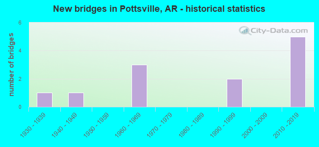
- New bridges - historical statistics
- 11930-1939
- 11940-1949
- 31960-1969
- 21990-1999
- 52010-2019


- Bridge Condition - Deck
- 75.0%Good
- 25.0%Satisfactory

- Bridge Condition - Superstructure
- 25.0%Very good
- 12.5%Good
- 62.5%Satisfactory

- Bridge Condition - Substructure
- 12.5%Very good
- 37.5%Good
- 50.0%Satisfactory

- Bridge Condition - Channel
- 40.0%Very good
- 50.0%Good
- 10.0%Satisfactory

- Bridge Condition - Culverts
- 50.0%Very good
- 25.0%Good
- 25.0%Satisfactory
Find on map >> Show street view
Structure Number: 3968, Location: 0.12 Mi North of US 64 (Lat: 35.257189, Lng: -93.052650), Route carried "on" structure: County highway 275, Year Built: 1967, Status: Open, Structure Length: 6.40m (21.00ft), Average Daily Traffic: 33 (year 1987), Truck Traffic: 1%, Average Future Daily Traffic: 57 (year 2007), Design Load: H 15, Features Intersected: I 40-SEC 22, Facility Carried by Structure: Galla Park Rd.
Minimum Vertical Clearance: 30+ m (98+ ft), Kilometerpoint: 0.193, Lanes on structure: 2, Lanes under structure: 4, Owner: State Highway Agency, Approaching Roadway Width: 8.2m (26.9ft), Material/Design: Steel, Design/Construction: Stringer/Multi-beam, Number Of Spans In Main Unit: 4, Length of Maximum Span: 20.4m (66.9ft), Curb or Sidewalk Widths: Left: 0.5m (1.6ft), Right: 0.5m (1.6ft), Curb-To-Curb Width: 7.3m (24.0ft), Out-to-Out Width: 9.0m (29.5ft)
Condition: Deck: Satisfactory, Superstructure: Satisfactory, Substructure: Good, Operating Rating: 49.0 metric tons, Method Used To Determine Operating Rating: Load Factor (LF), Inventory Rating: 29.0 metric tons, Method Used To Determine Inventory Rating: Load Factor (LF), Structural Evaluation: Equal to present minimum criteria, Deck Geometry: Equal to present minimum criteria, Underclear: Meets minimum limits, Approach Roadway Alignment: Equal to present desirable criteria, Designated Inspection Frequency: Every 24 months, Critical Feature Inspection Frequency: Every 24 months, Inspection Date: January 2022, Deck Structure Type: Concrete Cast-file-Place, Wearing Surface/Protective System: Wearing Surface: Monolithic Concrete
Find on map >> Show street view
Structure Number: 7115, Location: 5.94 Mi E of Jct SH 7 (Lat: 35.224361, Lng: -93.041161), Route carried "on" structure: State highway 247, Year Built: 2011, Status: Open, Structure Length: 14.94m (49.02ft), Average Daily Traffic: 4,900 (year 2018), Truck Traffic: 18%, Average Future Daily Traffic: 10,350 (year 2029), Design Load: HL 93, Features Intersected: Galla Creek
Minimum Vertical Clearance: 30+ m (98+ ft), Kilometerpoint: 9.560, Lanes on structure: 5, Owner: State Highway Agency, Approaching Roadway Width: 18.0m (59.1ft), Material/Design: Prestressed concrete continuous, Design/Construction: Stringer/Multi-beam, Number Of Spans In Main Unit: 7, Length of Maximum Span: 21.3m (69.9ft), Curb-To-Curb Width: 22.9m (75.1ft), Out-to-Out Width: 23.8m (78.1ft)
Condition: Deck: Good, Superstructure: Very good, Substructure: Good, Channel: Very good, Operating Rating: 54.4 metric tons, Method Used To Determine Operating Rating: Load Factor (LF), Inventory Rating: 32.7 metric tons, Method Used To Determine Inventory Rating: Load Factor (LF), Structural Evaluation: Better than present minimum criteria, Deck Geometry: Equal to present minimum criteria, Waterway Adequacy: Equal to present desirable criteria, Approach Roadway Alignment: Equal to present desirable criteria, Designated Inspection Frequency: Every 24 months, Critical Feature Inspection Frequency: Every 24 months, Inspection Date: December 2021, Deck Structure Type: Concrete Cast-file-Place, Wearing Surface/Protective System: Wearing Surface: Monolithic Concrete, Deck Protection: Epoxy Coated Reinforcing
Find on map >> Show street view
Structure Number: 7116, Location: 0.12 Mi. S Jct SH 64 (Lat: 35.246311, Lng: -93.036531), Route carried "on" structure: State highway 247, Year Built: 2011, Status: Open, Structure Length: 8.60m (28.22ft), Average Daily Traffic: 4,900 (year 2018), Truck Traffic: 18%, Average Future Daily Traffic: 10,350 (year 2029), Design Load: HL 93, Features Intersected: E Ash Rd & UP RR
Minimum Vertical Clearance: 30+ m (98+ ft), Kilometerpoint: 12.215, Lanes on structure: 5, Lanes under structure: 2, Owner: State Highway Agency, Approaching Roadway Width: 18.0m (59.1ft), Material/Design: Steel continuous, Design/Construction: Stringer/Multi-beam, Number Of Spans In Main Unit: 4, Length of Maximum Span: 22.3m (73.2ft), Curb-To-Curb Width: 22.9m (75.1ft), Out-to-Out Width: 23.8m (78.1ft)
Condition: Deck: Good, Superstructure: Good, Substructure: Good, Operating Rating: 54.4 metric tons, Method Used To Determine Operating Rating: Load Factor (LF), Inventory Rating: 32.7 metric tons, Method Used To Determine Inventory Rating: Load Factor (LF), Structural Evaluation: Better than present minimum criteria, Deck Geometry: Equal to present minimum criteria, Underclear: Meets minimum limits, Approach Roadway Alignment: Equal to present desirable criteria, Designated Inspection Frequency: Every 24 months, Critical Feature Inspection Frequency: Every 24 months, Inspection Date: December 2021, Deck Structure Type: Concrete Cast-file-Place, Wearing Surface/Protective System: Wearing Surface: Monolithic Concrete, Deck Protection: Epoxy Coated Reinforcing
Find on map >> Show street view
Structure Number: 7213, Location: .25 M W Jct SH 247 (Lat: 35.250489, Lng: -93.040319), Route carried "on" structure: US 64, Year Built: 2013, Status: Open, Structure Length: 6.59m (21.62ft), Average Daily Traffic: 7,000 (year 2018), Truck Traffic: 3%, Average Future Daily Traffic: 12,800 (year 2031), Design Load: HL 93, Features Intersected: Galla Creek
Minimum Vertical Clearance: 30+ m (98+ ft), Kilometerpoint: 27.150, Lanes on structure: 3, Owner: State Highway Agency, Approaching Roadway Width: 15.8m (51.8ft), Skew: 1 degrees, Material/Design: Steel continuous, Design/Construction: Stringer/Multi-beam, Number Of Spans In Main Unit: 4, Length of Maximum Span: 18.3m (60.0ft), Curb-To-Curb Width: 15.8m (51.8ft), Out-to-Out Width: 16.8m (55.1ft)
Condition: Deck: Good, Superstructure: Very good, Substructure: Very good, Channel: Very good, Operating Rating: 54.4 metric tons, Method Used To Determine Operating Rating: Load and Resistance Factor (LRFR), Inventory Rating: 32.7 metric tons, Method Used To Determine Inventory Rating: Load and Resistance Factor (LRFR), Structural Evaluation: Equal to present desirable criteria, Deck Geometry: Better than present minimum criteria, Waterway Adequacy: Equal to present desirable criteria, Approach Roadway Alignment: Equal to present desirable criteria, Designated Inspection Frequency: Every 24 months, Critical Feature Inspection Frequency: Every 24 months, Inspection Date: June 2021, Deck Structure Type: Concrete Cast-file-Place, Wearing Surface/Protective System: Wearing Surface: Monolithic Concrete, Membrane: Epoxy, Deck Protection: Epoxy Coated Reinforcing
Find on map >> Show street view
Structure Number: 1627, Location: 1.24 M NE from end SH 363 (Lat: 35.264028, Lng: -93.005828), Route carried "on" structure: County highway 34, Year Built: 1930, Year Reconstructed: 1970, Status: Posted for load, Structure Length: 1.95m (6.40ft), Average Daily Traffic: 1,036 (year 2018), Truck Traffic: 1%, Average Future Daily Traffic: 285 (year 2007), Features Intersected: Galla Creek, Facility Carried by Structure: Was SR 363
Minimum Vertical Clearance: 30+ m (98+ ft), Kilometerpoint: 1.996, Lanes on structure: 2, Owner: County Highway Agency, Approaching Roadway Width: 6.1m (20.0ft), Material/Design: Concrete, Design/Construction: Channel Beam, Number Of Spans In Main Unit: 1, Number Of Approach Spans: 1, Length of Maximum Span: 13.7m (44.9ft), Curb or Sidewalk Widths: Left: 0.2m (0.7ft), Right: 0.2m (0.7ft), Curb-To-Curb Width: 6.3m (20.7ft), Out-to-Out Width: 6.5m (21.3ft)
Condition: Deck: Good, Superstructure: Satisfactory, Substructure: Satisfactory, Channel: Good, Operating Rating: 29.9 metric tons, Method Used To Determine Operating Rating: Load Factor (LF), Inventory Rating: 18.1 metric tons, Method Used To Determine Inventory Rating: Load Factor (LF), Structural Evaluation: Somewhat better than minimum adequacy, Deck Geometry: High priority of replacement, Waterway Adequacy: Equal to present desirable criteria, Approach Roadway Alignment: Equal to present desirable criteria, Bridge Posting: Required (Relationship of Operating Rating to Maximum Legal Load: 20.0 - 29.9% below), Designated Inspection Frequency: Every 24 months, Critical Feature Inspection Frequency: Every 24 months, Inspection Date: June 2021, Deck Structure Type: Concrete Precast Panels, Wearing Surface/Protective System: Wearing Surface: Bituminous
Find on map >> Show street view
Structure Number: 18209, Location: 3.96 N SH 105 (Lat: 35.202642, Lng: -93.048950), Route carried "on" structure: City street 49120, Year Built: 1941, Status: Open, Structure Length: 0.73m (2.40ft), Average Daily Traffic: 1,200 (year 2018), Truck Traffic: 3%, Average Future Daily Traffic: 271 (year 2007), Features Intersected: Creek, Facility Carried by Structure: River Rd - A
Minimum Vertical Clearance: 30+ m (98+ ft), Kilometerpoint: 6.371, Lanes on structure: 2, Owner: City or Municipal Highway Agency, Approaching Roadway Width: 7.3m (24.0ft), Material/Design: Steel, Design/Construction: Stringer/Multi-beam, Number Of Spans In Main Unit: 1, Length of Maximum Span: 7.0m (23.0ft), Curb or Sidewalk Widths: Left: 0.2m (0.7ft), Right: 0.2m (0.7ft), Curb-To-Curb Width: 6.1m (20.0ft), Out-to-Out Width: 6.6m (21.7ft)
Condition: Deck: Satisfactory, Superstructure: Satisfactory, Substructure: Satisfactory, Channel: Good, Operating Rating: 37.2 metric tons, Method Used To Determine Operating Rating: Load Factor (LF), Inventory Rating: 21.8 metric tons, Method Used To Determine Inventory Rating: Load Factor (LF), Structural Evaluation: Somewhat better than minimum adequacy, Deck Geometry: High priority of replacement, Waterway Adequacy: Better than present minimum criteria, Approach Roadway Alignment: Somewhat better than minimum adequacy, Designated Inspection Frequency: Every 24 months, Critical Feature Inspection Frequency: Every 24 months, Inspection Date: May 2021, Deck Structure Type: Concrete Cast-file-Place, Wearing Surface/Protective System: Wearing Surface: Bituminous
Find on map >> Show street view
Structure Number: 21976, Location: .52 E OF SH 247 (Lat: 35.247889, Lng: -93.040778), Route carried "on" structure: City street 2210, Year Built: 1998, Status: Open, Structure Length: 1.80m (5.91ft), Average Daily Traffic: 919 (year 2018), Truck Traffic: 1%, Average Future Daily Traffic: 1,341 (year 2017), Features Intersected: Galla Creek, Facility Carried by Structure: E. Ash St - A
Minimum Vertical Clearance: 30+ m (98+ ft), Kilometerpoint: 0.837, Lanes on structure: 2, Owner: City or Municipal Highway Agency, Approaching Roadway Width: 10.4m (34.1ft), Skew: 3 degrees, Material/Design: Concrete, Design/Construction: Culvert, Number Of Spans In Main Unit: 4, Length of Maximum Span: 4.3m (14.1ft)
Condition: Channel: Satisfactory, Culverts: Good, Operating Rating: 32.7 metric tons, Method Used To Determine Operating Rating: Load Factor (LF), Inventory Rating: 20.0 metric tons, Method Used To Determine Inventory Rating: Load Factor (LF), Structural Evaluation: Somewhat better than minimum adequacy, Waterway Adequacy: Equal to present desirable criteria, Approach Roadway Alignment: Equal to present desirable criteria, Designated Inspection Frequency: Every 24 months, Critical Feature Inspection Frequency: Every 24 months, Inspection Date: June 2020
Find on map >> Show street view
Structure Number: 2252, Location: 1.8 MI E SH 331 (Lat: 35.284444, Lng: -93.057333), Route carried "on" structure: County highway 33, Year Built: 1995, Status: Open, Structure Length: 1.04m (3.41ft), Average Daily Traffic: 3,900 (year 2018), Truck Traffic: 2%, Average Future Daily Traffic: 1,916 (year 2021), Features Intersected: Cove Creek, Facility Carried by Structure: Bradley Cove Rd- B
Minimum Vertical Clearance: 30+ m (98+ ft), Kilometerpoint: 2.897, Lanes on structure: 2, Owner: County Highway Agency, Approaching Roadway Width: 7.0m (23.0ft), Material/Design: Steel, Design/Construction: Culvert, Number Of Spans In Main Unit: 3, Length of Maximum Span: 3.4m (11.2ft)
Condition: Channel: Good, Culverts: Satisfactory, Operating Rating: 54.4 metric tons, Method Used To Determine Operating Rating: Load Factor (LF), Inventory Rating: 32.7 metric tons, Method Used To Determine Inventory Rating: Load Factor (LF), Structural Evaluation: Equal to present minimum criteria, Waterway Adequacy: Better than present minimum criteria, Approach Roadway Alignment: Equal to present desirable criteria, Designated Inspection Frequency: Every 24 months, Critical Feature Inspection Frequency: Every 24 months, Inspection Date: August 2021
Find on map >> Show street view
Structure Number: A3969, Location: 0.31 M W Jct SH 363 (Lat: 35.251631, Lng: -93.040161), Route carried "on" structure: Interstate 40, Year Built: 1967, Status: Open, Structure Length: 5.97m (19.59ft), Average Daily Traffic: 8,000 (year 2018), Truck Traffic: 1%, Average Future Daily Traffic: 17,882 (year 2028), Design Load: HS 20+Mod, Features Intersected: Galla Creek
Minimum Vertical Clearance: 30+ m (98+ ft), Kilometerpoint: 141.381, Lanes on structure: 2, Base Highway Network: Yes, Owner: State Highway Agency, Approaching Roadway Width: 12.2m (40.0ft), Skew: 1 degrees, Material/Design: Concrete, Design/Construction: Slab, Number Of Spans In Main Unit: 7, Length of Maximum Span: 8.5m (27.9ft), Curb or Sidewalk Widths: Left: 0.2m (0.7ft), Right: 0.2m (0.7ft), Curb-To-Curb Width: 11.9m (39.0ft), Out-to-Out Width: 12.9m (42.3ft)
Condition: Deck: Good, Superstructure: Satisfactory, Substructure: Satisfactory, Channel: Good, Operating Rating: 54.4 metric tons, Method Used To Determine Operating Rating: Load Factor (LF), Inventory Rating: 32.7 metric tons, Method Used To Determine Inventory Rating: Load Factor (LF), Structural Evaluation: Equal to present minimum criteria, Deck Geometry: Equal to present minimum criteria, Waterway Adequacy: Equal to present desirable criteria, Approach Roadway Alignment: Equal to present desirable criteria, Designated Inspection Frequency: Every 24 months, Critical Feature Inspection Frequency: Every 24 months, Inspection Date: January 2022, Deck Structure Type: Concrete Cast-file-Place, Wearing Surface/Protective System: Wearing Surface: Latex Concrete
Find on map >> Show street view
Structure Number: B3969, Location: 0.31 M W of SH 363 (Lat: 35.251389, Lng: -93.040219), Route carried "on" structure: Interstate 40, Year Built: 1967, Status: Open, Structure Length: 5.97m (19.59ft), Average Daily Traffic: 8,000 (year 2018), Truck Traffic: 24%, Average Future Daily Traffic: 17,882 (year 2028), Design Load: HS 20+Mod, Features Intersected: Galla Creek
Minimum Vertical Clearance: 30+ m (98+ ft), Kilometerpoint: 141.381, Lanes on structure: 2, Base Highway Network: Yes, Owner: State Highway Agency, Approaching Roadway Width: 12.2m (40.0ft), Skew: 1 degrees, Material/Design: Concrete, Design/Construction: Slab, Number Of Spans In Main Unit: 7, Length of Maximum Span: 8.5m (27.9ft), Curb or Sidewalk Widths: Left: 0.2m (0.7ft), Right: 0.2m (0.7ft), Curb-To-Curb Width: 11.9m (39.0ft), Out-to-Out Width: 12.9m (42.3ft)
Condition: Deck: Good, Superstructure: Satisfactory, Substructure: Satisfactory, Channel: Good, Operating Rating: 54.4 metric tons, Method Used To Determine Operating Rating: Load Factor (LF), Inventory Rating: 32.7 metric tons, Method Used To Determine Inventory Rating: Load Factor (LF), Structural Evaluation: Equal to present minimum criteria, Deck Geometry: Equal to present minimum criteria, Waterway Adequacy: Equal to present desirable criteria, Approach Roadway Alignment: Equal to present desirable criteria, Designated Inspection Frequency: Every 24 months, Critical Feature Inspection Frequency: Every 24 months, Inspection Date: January 2022, Deck Structure Type: Concrete Cast-file-Place, Wearing Surface/Protective System: Wearing Surface: Latex Concrete
Find on map >> Show street view
Structure Number: X1187, Location: 3.7 Mi E of Jct SH 7 (Lat: 35.223189, Lng: -93.079681), Route carried "on" structure: State highway 247, Year Built: 2011, Status: Open, Structure Length: 1.18m (3.87ft), Average Daily Traffic: 7,300 (year 2018), Truck Traffic: 16%, Average Future Daily Traffic: 10,350 (year 2029), Design Load: HS 20+Mod, Features Intersected: Tanyard Branch
Minimum Vertical Clearance: 30+ m (98+ ft), Kilometerpoint: 5.955, Lanes on structure: 5, Owner: State Highway Agency, Approaching Roadway Width: 18.0m (59.1ft), Skew: 3 degrees, Material/Design: Concrete, Design/Construction: Culvert, Number Of Spans In Main Unit: 3, Length of Maximum Span: 3.0m (9.8ft)
Condition: Channel: Very good, Culverts: Very good, Operating Rating: 35.4 metric tons, Method Used To Determine Operating Rating: Load Factor (LF), Inventory Rating: 21.8 metric tons, Method Used To Determine Inventory Rating: Load Factor (LF), Structural Evaluation: Somewhat better than minimum adequacy, Waterway Adequacy: Equal to present desirable criteria, Approach Roadway Alignment: Equal to present desirable criteria, Designated Inspection Frequency: Every 24 months, Critical Feature Inspection Frequency: Every 24 months, Inspection Date: December 2021
Find on map >> Show street view
Structure Number: X1544, Location: 0.16 M S Jct US 64 (Lat: 35.251408, Lng: -93.048478), Route carried "on" structure: State highway 331, Year Built: 2018, Status: Open, Structure Length: 1.09m (3.58ft), Average Daily Traffic: 2,700 (year 2018), Truck Traffic: 4%, Average Future Daily Traffic: 4,100 (year 2038), Design Load: HL 93, Features Intersected: Creek
Minimum Vertical Clearance: 30.44m (99.87ft), Kilometerpoint: 0.241, Lanes on structure: 2, Owner: State Highway Agency, Approaching Roadway Width: 6.7m (22.0ft), Material/Design: Concrete, Design/Construction: Culvert, Number Of Spans In Main Unit: 3, Length of Maximum Span: 3.0m (9.8ft)
Condition: Channel: Very good, Culverts: Very good, Operating Rating: 54.4 metric tons, Method Used To Determine Operating Rating: Load and Resistance Factor (LRFR), Inventory Rating: 32.7 metric tons, Method Used To Determine Inventory Rating: Load and Resistance Factor (LRFR), Structural Evaluation: Equal to present desirable criteria, Waterway Adequacy: Equal to present desirable criteria, Approach Roadway Alignment: Equal to present minimum criteria, Designated Inspection Frequency: Every 24 months, Critical Feature Inspection Frequency: Every 24 months, Inspection Date: January 2021
Find on map >> Show street view
Structure Number: 3968, Location: 0.12 Mi North of US 64 (Lat: 35.257189, Lng: -93.052650), Route carried "under" structure: Interstate 40, Structure Length: 0. m, Average Daily Traffic: 14,000 (year 2012), Truck Traffic: 1%, Features Intersected: I 40-SEC 22, Facility Carried by Structure: Galla Park Rd.
Minimum Vertical Clearance: 5.02m (16.47ft), Kilometerpoint: 140.077, Length of Maximum Span: 0.0m
Find on map >> Show street view
Structure Number: 3968, Location: 0.12 Mi North of US 64 (Lat: 35.257189, Lng: -93.052650), Route carried "under" structure: Interstate 40, Structure Length: 0. m, Average Daily Traffic: 14,000 (year 2012), Truck Traffic: 1%, Features Intersected: I 40-SEC 22, Facility Carried by Structure: Galla Park Rd.
Minimum Vertical Clearance: 5.00m (16.40ft), Kilometerpoint: 140.077, Length of Maximum Span: 0.0m
Find on map >> Show street view
Structure Number: 397, Location: 0.08 M N Jct SH 64 (Lat: 35.249439, Lng: -93.035211), Route carried "under" structure: Interstate 40, Structure Length: 0. m, Average Daily Traffic: 14,500 (year 2014), Truck Traffic: 1%, Features Intersected: I 40-SEC 22, Facility Carried by Structure: SH 363-SEC 1
Minimum Vertical Clearance: 5.38m (17.65ft), Kilometerpoint: 141.880, Length of Maximum Span: 0.0m
Find on map >> Show street view
Structure Number: 397, Location: 0.08 M N Jct SH 64 (Lat: 35.249439, Lng: -93.035211), Route carried "under" structure: Interstate 40, Structure Length: 0. m, Average Daily Traffic: 14,500 (year 2014), Truck Traffic: 1%, Features Intersected: I 40-SEC 22, Facility Carried by Structure: SH 363-SEC 1
Minimum Vertical Clearance: 5.02m (16.47ft), Kilometerpoint: 141.880, Length of Maximum Span: 0.0m
Find on map >> Show street view
Structure Number: 7116, Location: 0.12 Mi. S Jct SH 64 (Lat: 35.246311, Lng: -93.036531), Route carried "under" structure: City street 2210, Structure Length: 0. m, Average Daily Traffic: 25 (year 2012), Features Intersected: E Ash Rd & UP RR, Facility Carried by Structure: SH 247
Minimum Vertical Clearance: 11.49m (37.70ft), Kilometerpoint: 1.207, Length of Maximum Span: 0.0m
Find on map >> Show street view
Structure Number: M2532, Location: .11 MI S JCT US 64 (Lat: 35.251667, Lng: -93.048333), Route carried "under" structure: State highway 331, Structure Length: 0. m, Average Daily Traffic: 3,600 (year 2014), Truck Traffic: 1%, Features Intersected: SH 331-SEC 0, Facility Carried by Structure: UNION PACIFIC RR
Minimum Vertical Clearance: 3.50m (11.48ft), Kilometerpoint: 0.177, Length of Maximum Span: 0.0m