Bridge Statistics for Potterville, Michigan (MI)
Condition, Traffic, Stress, Structural Evaluation, Project Costs
- National Bridge Inventory (NBI) Statistics
- 32Number of bridges
- 177ft / 53.9mTotal length
- $250,000Total costs
- 236,044Total average daily traffic
- 32,085Total average daily truck traffic
- National Bridge Inventory (NBI) Registered Bridges for Potterville
- No street view available for this location
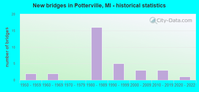
- New bridges - historical statistics
- 21950-1959
- 21960-1969
- 161980-1989
- 51990-1999
- 32000-2009
- 32010-2019
- 12020-2022


- Bridge Condition - Deck
- 5.3%Excellent
- 10.5%Very good
- 47.4%Good
- 26.3%Satisfactory
- 10.5%Fair

- Bridge Condition - Superstructure
- 10.5%Excellent
- 21.1%Very good
- 31.6%Good
- 36.8%Satisfactory

- Bridge Condition - Substructure
- 5.3%Excellent
- 68.4%Good
- 21.1%Satisfactory
- 5.3%Fair

- Bridge Condition - Channel
- 5.6%Excellent
- 27.8%Very good
- 38.9%Good
- 22.2%Satisfactory
- 5.6%Fair

- Bridge Condition - Culverts
- 16.7%Excellent
- 33.3%Very good
- 50.0%Good
Find on map >> Show street view
Structure Number: 2216, Location: 1.0 MI SW OF POTTERVILLE (Lat: 42.616125, Lng: -84.751361), Route carried "on" structure: County highway , Year Built: 1957, Year Reconstructed: 2008, Status: Open, Structure Length: 1.07m (3.51ft), Average Daily Traffic: 6,274 (year 2007), Truck Traffic: 8%, Average Future Daily Traffic: 11,100 (year 2028), Design Load: HS 20, Features Intersected: THORNAPPLE RIVER, Facility Carried by Structure: LANSING RD
Minimum Vertical Clearance: 30.48m (100.00ft), Kilometerpoint: 9.186, Lanes on structure: 2, Owner: County Highway Agency, Approaching Roadway Width: 14.0m (45.9ft), Material/Design: Steel, Design/Construction: Stringer/Multi-beam, Number Of Spans In Main Unit: 1, Length of Maximum Span: 10.2m (33.5ft), Curb-To-Curb Width: 17.6m (57.7ft), Out-to-Out Width: 18.3m (60.0ft)
Condition: Deck: Good, Superstructure: Good, Substructure: Good, Channel: Very good, Operating Rating: 62.9 metric tons, Method Used To Determine Operating Rating: Load Factor (LF) rating reported by rating factor (RF) method using MS18 loading, Inventory Rating: 37.6 metric tons, Method Used To Determine Inventory Rating: Load Factor (LF) rating reported by rating factor (RF) method using MS18 loading, Structural Evaluation: Better than present minimum criteria, Deck Geometry: Superior to present desirable criteria, Waterway Adequacy: Equal to present minimum criteria, Approach Roadway Alignment: Equal to present desirable criteria, Designated Inspection Frequency: Every 24 months, Inspection Date: June 2021, Deck Structure Type: Concrete Cast-file-Place, Wearing Surface/Protective System: Wearing Surface: Monolithic Concrete, Deck Protection: Epoxy Coated Reinforcing
Find on map >> Show street view
Structure Number: 2262, Location: 0.4 MI SW OF POTTERVILLE (Lat: 42.615119, Lng: -84.749600), Route carried "on" structure: Interstate 69, Year Built: 1989, Status: Open, Structure Length: 1.92m (6.30ft), Average Daily Traffic: 14,585 (year 2007), Truck Traffic: 18%, Average Future Daily Traffic: 18,576 (year 2018), Design Load: HS 25 or greater, Features Intersected: THORNAPPLE RIVER
Minimum Vertical Clearance: 30+ m (98+ ft), Kilometerpoint: 29.845, Lanes on structure: 2, Base Highway Network: Yes (Inventory Route: 56, Subroute: 1), Owner: State Highway Agency, Approaching Roadway Width: 14.0m (45.9ft), Skew: 2 degrees, Material/Design: Prestressed concrete, Design/Construction: Stringer/Multi-beam, Number Of Spans In Main Unit: 1, Length of Maximum Span: 19.2m (63.0ft), Curb-To-Curb Width: 13.4m (44.0ft), Out-to-Out Width: 14.4m (47.2ft)
Condition: Deck: Good, Superstructure: Very good, Substructure: Good, Channel: Good, Operating Rating: 63.2 metric tons, Method Used To Determine Operating Rating: Load and Resistance Factor Rating (LRFR) rating reported by rating factor(RF) method using HL-93 loadings, Inventory Rating: 42.4 metric tons, Method Used To Determine Inventory Rating: Load and Resistance Factor Rating (LRFR) rating reported by rating factor(RF) method using HL-93 loadings, Structural Evaluation: Better than present minimum criteria, Deck Geometry: Superior to present desirable criteria, Waterway Adequacy: Equal to present desirable criteria, Approach Roadway Alignment: Equal to present desirable criteria, Designated Inspection Frequency: Every 24 months, Inspection Date: June 2021, Deck Structure Type: Concrete Cast-file-Place, Wearing Surface/Protective System: Wearing Surface: Epoxy Overlay, Deck Protection: Epoxy Coated Reinforcing
Find on map >> Show street view
Structure Number: 2263, Location: 0.4 MI SW OF POTTERVILLE (Lat: 42.615350, Lng: -84.749958), Route carried "on" structure: Interstate 69, Year Built: 1989, Status: Open, Structure Length: 1.92m (6.30ft), Average Daily Traffic: 14,585 (year 2007), Truck Traffic: 18%, Average Future Daily Traffic: 18,576 (year 2018), Design Load: HS 25 or greater, Features Intersected: THORNAPPLE RIVER
Minimum Vertical Clearance: 30.48m (100.00ft), Kilometerpoint: 29.899, Lanes on structure: 2, Base Highway Network: Yes (Inventory Route: 56, Subroute: 1), Owner: State Highway Agency, Approaching Roadway Width: 14.0m (45.9ft), Skew: 1 degrees, Material/Design: Prestressed concrete, Design/Construction: Stringer/Multi-beam, Number Of Spans In Main Unit: 1, Length of Maximum Span: 19.2m (63.0ft), Curb-To-Curb Width: 13.4m (44.0ft), Out-to-Out Width: 14.4m (47.2ft)
Condition: Deck: Good, Superstructure: Very good, Substructure: Good, Channel: Satisfactory, Operating Rating: 63.2 metric tons, Method Used To Determine Operating Rating: Load and Resistance Factor Rating (LRFR) rating reported by rating factor(RF) method using HL-93 loadings, Inventory Rating: 42.4 metric tons, Method Used To Determine Inventory Rating: Load and Resistance Factor Rating (LRFR) rating reported by rating factor(RF) method using HL-93 loadings, Structural Evaluation: Better than present minimum criteria, Deck Geometry: Superior to present desirable criteria, Waterway Adequacy: Equal to present desirable criteria, Approach Roadway Alignment: Equal to present desirable criteria, Designated Inspection Frequency: Every 24 months, Inspection Date: June 2021, Deck Structure Type: Concrete Cast-file-Place, Wearing Surface/Protective System: Wearing Surface: Epoxy Overlay, Deck Protection: Epoxy Coated Reinforcing
Find on map >> Show street view
Structure Number: 2271, Location: 3.0 MI NE OF CHARLOTTE (Lat: 42.606144, Lng: -84.768128), Route carried "on" structure: Interstate 69, Year Built: 1989, Status: Open, Structure Length: 6.15m (20.18ft), Average Daily Traffic: 14,585 (year 2007), Truck Traffic: 18%, Average Future Daily Traffic: 18,576 (year 2018), Design Load: HS 25 or greater, Features Intersected: LANSING ROAD
Minimum Vertical Clearance: 30.48m (100.00ft), Kilometerpoint: 28.024, Lanes on structure: 2, Lanes under structure: 3, Base Highway Network: Yes (Inventory Route: 56, Subroute: 1), Owner: State Highway Agency, Approaching Roadway Width: 13.7m (44.9ft), Skew: 5 degrees, Material/Design: Prestressed concrete, Design/Construction: Stringer/Multi-beam, Number Of Spans In Main Unit: 3, Length of Maximum Span: 30.4m (99.7ft), Curb-To-Curb Width: 13.4m (44.0ft), Out-to-Out Width: 14.7m (48.2ft)
Condition: Deck: Fair, Superstructure: Satisfactory, Substructure: Satisfactory, Operating Rating: 75.5 metric tons, Method Used To Determine Operating Rating: Load Factor (LF) rating reported by rating factor (RF) method using MS18 loading, Inventory Rating: 45.0 metric tons, Method Used To Determine Inventory Rating: Load Factor (LF) rating reported by rating factor (RF) method using MS18 loading, Structural Evaluation: Equal to present minimum criteria, Deck Geometry: Superior to present desirable criteria, Underclear: Meets minimum limits, Approach Roadway Alignment: Equal to present desirable criteria, Designated Inspection Frequency: Every 24 months, Inspection Date: June 2021, Deck Structure Type: Concrete Cast-file-Place, Wearing Surface/Protective System: Wearing Surface: Latex Concrete, Deck Protection: Epoxy Coated Reinforcing
Find on map >> Show street view
Structure Number: 2272, Location: 3.0 MI NE OF CHARLOTTE (Lat: 42.606667, Lng: -84.767758), Route carried "on" structure: Interstate 69, Year Built: 1989, Status: Open, Structure Length: 6.15m (20.18ft), Average Daily Traffic: 14,585 (year 2007), Truck Traffic: 18%, Average Future Daily Traffic: 18,576 (year 2018), Design Load: HS 25 or greater, Features Intersected: LANSING ROAD
Minimum Vertical Clearance: 30.48m (100.00ft), Kilometerpoint: 28.144, Lanes on structure: 2, Lanes under structure: 3, Base Highway Network: Yes (Inventory Route: 56, Subroute: 1), Owner: State Highway Agency, Approaching Roadway Width: 13.7m (44.9ft), Skew: 5 degrees, Material/Design: Prestressed concrete, Design/Construction: Stringer/Multi-beam, Number Of Spans In Main Unit: 3, Length of Maximum Span: 30.4m (99.7ft), Curb-To-Curb Width: 13.4m (44.0ft), Out-to-Out Width: 14.3m (46.9ft)
Condition: Deck: Fair, Superstructure: Satisfactory, Substructure: Good, Operating Rating: 77.1 metric tons, Method Used To Determine Operating Rating: Load Factor (LF) rating reported by rating factor (RF) method using MS18 loading, Inventory Rating: 46.0 metric tons, Method Used To Determine Inventory Rating: Load Factor (LF) rating reported by rating factor (RF) method using MS18 loading, Structural Evaluation: Equal to present minimum criteria, Deck Geometry: Superior to present desirable criteria, Underclear: Meets minimum limits, Approach Roadway Alignment: Equal to present desirable criteria, Designated Inspection Frequency: Every 24 months, Inspection Date: June 2021, Deck Structure Type: Concrete Cast-file-Place, Wearing Surface/Protective System: Wearing Surface: Latex Concrete, Deck Protection: Epoxy Coated Reinforcing
Find on map >> Show street view
Structure Number: 2273, Location: AT S LIMITS POTTERVILLE (Lat: 42.620428, Lng: -84.738933), Route carried "on" structure: Interstate 69, Year Built: 1989, Status: Open, Structure Length: 5.76m (18.90ft), Average Daily Traffic: 17,026 (year 2007), Truck Traffic: 18%, Average Future Daily Traffic: 18,683 (year 2018), Design Load: HS 25 or greater, Features Intersected: M-100
Minimum Vertical Clearance: 30.48m (100.00ft), Kilometerpoint: 30.900, Lanes on structure: 2, Lanes under structure: 2, Base Highway Network: Yes (Inventory Route: 56, Subroute: 1), Owner: State Highway Agency, Approaching Roadway Width: 14.6m (47.9ft), Skew: 3 degrees, Material/Design: Prestressed concrete, Design/Construction: Stringer/Multi-beam, Number Of Spans In Main Unit: 3, Length of Maximum Span: 32.0m (105.0ft), Curb-To-Curb Width: 13.4m (44.0ft), Out-to-Out Width: 14.4m (47.2ft)
Condition: Deck: Good, Superstructure: Satisfactory, Substructure: Satisfactory, Operating Rating: 81.2 metric tons, Method Used To Determine Operating Rating: Load Factor (LF), Inventory Rating: 47.7 metric tons, Method Used To Determine Inventory Rating: Load Factor (LF), Structural Evaluation: Equal to present minimum criteria, Deck Geometry: Superior to present desirable criteria, Underclear: Superior to present desirable criteria, Approach Roadway Alignment: Equal to present desirable criteria, Designated Inspection Frequency: Every 24 months, Inspection Date: June 2021, Deck Structure Type: Concrete Cast-file-Place, Wearing Surface/Protective System: Wearing Surface: Epoxy Overlay, Deck Protection: Epoxy Coated Reinforcing
Find on map >> Show street view
Structure Number: 2275, Location: 2.0 MI NE OF POTTERVILLE (Lat: 42.646294, Lng: -84.700003), Route carried "on" structure: Interstate 69, Year Built: 1989, Status: Open, Structure Length: 2.62m (8.60ft), Average Daily Traffic: 17,026 (year 2007), Truck Traffic: 18%, Average Future Daily Traffic: 18,683 (year 2018), Design Load: HS 25 or greater, Features Intersected: WINDSOR & NIXON HWY
Minimum Vertical Clearance: 30.48m (100.00ft), Kilometerpoint: 35.227, Lanes on structure: 2, Lanes under structure: 2, Base Highway Network: Yes (Inventory Route: 56, Subroute: 1), Owner: State Highway Agency, Approaching Roadway Width: 12.8m (42.0ft), Material/Design: Prestressed concrete, Design/Construction: Stringer/Multi-beam, Number Of Spans In Main Unit: 1, Length of Maximum Span: 26.2m (86.0ft), Curb-To-Curb Width: 13.4m (44.0ft), Out-to-Out Width: 14.4m (47.2ft)
Condition: Deck: Satisfactory, Superstructure: Good, Substructure: Good, Operating Rating: 71.9 metric tons, Method Used To Determine Operating Rating: Load Factor (LF) rating reported by rating factor (RF) method using MS18 loading, Inventory Rating: 44.1 metric tons, Method Used To Determine Inventory Rating: Load Factor (LF) rating reported by rating factor (RF) method using MS18 loading, Structural Evaluation: Better than present minimum criteria, Deck Geometry: Superior to present desirable criteria, Underclear: Better than present minimum criteria, Approach Roadway Alignment: Equal to present desirable criteria, Designated Inspection Frequency: Every 24 months, Inspection Date: June 2021, Deck Structure Type: Concrete Cast-file-Place, Wearing Surface/Protective System: Wearing Surface: Latex Concrete, Deck Protection: Epoxy Coated Reinforcing
Find on map >> Show street view
Structure Number: 2276, Location: 2.0 MI NE OF POTTERVILLE (Lat: 42.646558, Lng: -84.700286), Route carried "on" structure: Interstate 69, Year Built: 1989, Status: Open, Structure Length: 2.62m (8.60ft), Average Daily Traffic: 17,026 (year 2007), Truck Traffic: 18%, Average Future Daily Traffic: 18,683 (year 2018), Design Load: HS 25 or greater, Features Intersected: NIXON ROAD
Minimum Vertical Clearance: 30.48m (100.00ft), Kilometerpoint: 35.289, Lanes on structure: 2, Lanes under structure: 2, Base Highway Network: Yes (Inventory Route: 56, Subroute: 1), Owner: State Highway Agency, Approaching Roadway Width: 12.8m (42.0ft), Material/Design: Prestressed concrete, Design/Construction: Stringer/Multi-beam, Number Of Spans In Main Unit: 1, Length of Maximum Span: 26.2m (86.0ft), Curb-To-Curb Width: 13.4m (44.0ft), Out-to-Out Width: 14.4m (47.2ft)
Condition: Deck: Good, Superstructure: Good, Substructure: Satisfactory, Operating Rating: 71.3 metric tons, Method Used To Determine Operating Rating: Load Factor (LF) rating reported by rating factor (RF) method using MS18 loading, Inventory Rating: 43.7 metric tons, Method Used To Determine Inventory Rating: Load Factor (LF) rating reported by rating factor (RF) method using MS18 loading, Structural Evaluation: Equal to present minimum criteria, Deck Geometry: Superior to present desirable criteria, Underclear: Equal to present minimum criteria, Approach Roadway Alignment: Equal to present desirable criteria, Designated Inspection Frequency: Every 24 months, Inspection Date: June 2021, Deck Structure Type: Concrete Cast-file-Place, Wearing Surface/Protective System: Wearing Surface: Latex Concrete, Deck Protection: Epoxy Coated Reinforcing
Find on map >> Show street view
Structure Number: 2282, Location: AT S LIMITS POTTERVILLE (Lat: 42.620825, Lng: -84.738925), Route carried "on" structure: Interstate 69, Year Built: 1989, Status: Open, Structure Length: 5.76m (18.90ft), Average Daily Traffic: 17,026 (year 2007), Truck Traffic: 18%, Average Future Daily Traffic: 18,683 (year 2018), Design Load: HS 25 or greater, Features Intersected: M-100
Minimum Vertical Clearance: 30.48m (100.00ft), Kilometerpoint: 30.989, Lanes on structure: 2, Lanes under structure: 2, Base Highway Network: Yes (Inventory Route: 56, Subroute: 1), Owner: State Highway Agency, Approaching Roadway Width: 14.6m (47.9ft), Skew: 3 degrees, Material/Design: Prestressed concrete, Design/Construction: Stringer/Multi-beam, Number Of Spans In Main Unit: 3, Length of Maximum Span: 32.0m (105.0ft), Curb-To-Curb Width: 13.4m (44.0ft), Out-to-Out Width: 14.4m (47.2ft)
Condition: Deck: Satisfactory, Superstructure: Satisfactory, Substructure: Good, Inventory Rating: 49.9 metric tons, Method Used To Determine Inventory Rating: Load Factor (LF), Structural Evaluation: Equal to present minimum criteria, Deck Geometry: Superior to present desirable criteria, Underclear: Better than present minimum criteria, Approach Roadway Alignment: Equal to present desirable criteria, Designated Inspection Frequency: Every 24 months, Inspection Date: June 2021, Deck Structure Type: Concrete Cast-file-Place, Wearing Surface/Protective System: Wearing Surface: Epoxy Overlay, Deck Protection: Epoxy Coated Reinforcing
Find on map >> Show street view
Structure Number: 2283, Location: 3.5 MI N OF I-69 (Lat: 42.673228, Lng: -84.739417), Route carried "on" structure: State highway 100, Year Built: 2015, Status: Open, Structure Length: 1.04m (3.41ft), Average Daily Traffic: 5,425 (year 2015), Truck Traffic: 4%, Average Future Daily Traffic: 6,300 (year 2035), Design Load: Greater than HL93, Features Intersected: THORNAPPLE DRAIN
Minimum Vertical Clearance: 30.48m (100.00ft), Kilometerpoint: 6.085, Lanes on structure: 2, Base Highway Network: Yes (Inventory Route: 56, Subroute: 10), Owner: State Highway Agency, Approaching Roadway Width: 13.7m (44.9ft), Material/Design: Concrete, Design/Construction: Culvert, Number Of Spans In Main Unit: 1, Length of Maximum Span: 9.8m (32.2ft), Curb-To-Curb Width: 13.7m (44.9ft), Out-to-Out Width: 14.5m (47.6ft)
Condition: Channel: Good, Culverts: Excellent, Operating Rating: 42.1 metric tons, Method Used To Determine Operating Rating: Load and Resistance Factor Rating (LRFR) rating reported by rating factor(RF) method using HL-93 loadings, Inventory Rating: 32.7 metric tons, Method Used To Determine Inventory Rating: Load and Resistance Factor Rating (LRFR) rating reported by rating factor(RF) method using HL-93 loadings, Structural Evaluation: Superior to present desirable criteria, Deck Geometry: Superior to present desirable criteria, Waterway Adequacy: Equal to present desirable criteria, Approach Roadway Alignment: Equal to present desirable criteria, Designated Inspection Frequency: Every 24 months, Inspection Date: July 2021, Wearing Surface/Protective System: Wearing Surface: Bituminous
Find on map >> Show street view
Structure Number: 2285, Location: N LTS OF POTTERVILLE (Lat: 42.632533, Lng: -84.739025), Route carried "on" structure: State highway 100, Year Built: 2015, Status: Open, Structure Length: 3.28m (10.76ft), Average Daily Traffic: 5,425 (year 2015), Truck Traffic: 4%, Average Future Daily Traffic: 6,300 (year 2035), Design Load: Greater than HL93, Features Intersected: GTW RR
Minimum Vertical Clearance: 30.48m (100.00ft), Kilometerpoint: 1.560, Lanes on structure: 2, Base Highway Network: Yes (Inventory Route: 56, Subroute: 10), Owner: State Highway Agency, Approaching Roadway Width: 12.8m (42.0ft), Skew: 3 degrees, Material/Design: Steel, Design/Construction: Stringer/Multi-beam, Number Of Spans In Main Unit: 1, Length of Maximum Span: 31.2m (102.4ft), Curb or Sidewalk Widths: Left: 3.0m (9.8ft), Right: 0.0m, Curb-To-Curb Width: 13.4m (44.0ft), Out-to-Out Width: 17.5m (57.4ft)
Condition: Deck: Good, Superstructure: Very good, Substructure: Good, Operating Rating: 53.1 metric tons, Method Used To Determine Operating Rating: Load and Resistance Factor Rating (LRFR) rating reported by rating factor(RF) method using HL-93 loadings, Inventory Rating: 40.8 metric tons, Method Used To Determine Inventory Rating: Load and Resistance Factor Rating (LRFR) rating reported by rating factor(RF) method using HL-93 loadings, Structural Evaluation: Better than present minimum criteria, Deck Geometry: Equal to present minimum criteria, Approach Roadway Alignment: Equal to present desirable criteria, Designated Inspection Frequency: Every 24 months, Inspection Date: July 2021, Deck Structure Type: Concrete Cast-file-Place, Wearing Surface/Protective System: Wearing Surface: Monolithic Concrete, Deck Protection: Epoxy Coated Reinforcing
Find on map >> Show street view
Structure Number: 2342, Location: 5 MI S OF POTTERVILLE (Lat: 42.567483, Lng: -84.715881), Route carried "on" structure: County highway 2340, Year Built: 2001, Status: Open, Structure Length: 0.79m (2.59ft), Average Daily Traffic: 2,045 (year 2012), Average Future Daily Traffic: 2,515 (year 2013), Design Load: HS 20, Features Intersected: THORNAPPLE RIVER, Facility Carried by Structure: ISLAND HWY
Minimum Vertical Clearance: 30.48m (100.00ft), Kilometerpoint: 9.661, Lanes on structure: 2, Owner: County Highway Agency, Approaching Roadway Width: 7.0m (23.0ft), Skew: 4 degrees, Material/Design: Steel, Design/Construction: Culvert, Number Of Spans In Main Unit: 1, Length of Maximum Span: 7.6m (24.9ft), Curb-To-Curb Width: 6.0m (19.7ft), Out-to-Out Width: 6.7m (22.0ft)
Condition: Channel: Good, Culverts: Very good, Operating Rating: 43.7 metric tons, Method Used To Determine Operating Rating: Load and Resistance Factor Rating (LRFR) rating reported by rating factor(RF) method using HL-93 loadings, Inventory Rating: 33.4 metric tons, Method Used To Determine Inventory Rating: Load and Resistance Factor Rating (LRFR) rating reported by rating factor(RF) method using HL-93 loadings, Structural Evaluation: Equal to present desirable criteria, Deck Geometry: High priority of replacement, Waterway Adequacy: Equal to present desirable criteria, Approach Roadway Alignment: Equal to present desirable criteria, Designated Inspection Frequency: Every 24 months, Inspection Date: May 2021, Wearing Surface/Protective System: Wearing Surface: Bituminous
Find on map >> Show street view
Structure Number: 2346, Location: 2 MI W OF POTTERVILLE (Lat: 42.625867, Lng: -84.774328), Route carried "on" structure: County highway 2360, Year Built: 2021, Status: Open, Structure Length: 1.65m (5.41ft), Average Daily Traffic: 2,654 (year 2020), Truck Traffic: 2%, Average Future Daily Traffic: 3,131 (year 2040), Design Load: Greater than HL93, Features Intersected: THORNAPPLE RIVER, Facility Carried by Structure: VERMONTVILLE HWY
Minimum Vertical Clearance: 30.48m (100.00ft), Kilometerpoint: 25.263, Lanes on structure: 2, Owner: County Highway Agency, Approaching Roadway Width: 10.5m (34.4ft), Skew: 1 degrees, Material/Design: Prestressed concrete, Design/Construction: Box Beam or Girders - Single/Spread, Number Of Spans In Main Unit: 1, Length of Maximum Span: 16.1m (52.8ft), Curb-To-Curb Width: 10.4m (34.1ft), Out-to-Out Width: 11.4m (37.4ft)
Condition: Deck: Excellent, Superstructure: Excellent, Substructure: Excellent, Channel: Very good, Operating Rating: 57.7 metric tons, Method Used To Determine Operating Rating: Load and Resistance Factor Rating (LRFR) rating reported by rating factor(RF) method using HL-93 loadings, Inventory Rating: 44.4 metric tons, Method Used To Determine Inventory Rating: Load and Resistance Factor Rating (LRFR) rating reported by rating factor(RF) method using HL-93 loadings, Structural Evaluation: Superior to present desirable criteria, Deck Geometry: Somewhat better than minimum adequacy, Waterway Adequacy: Better than present minimum criteria, Approach Roadway Alignment: Equal to present desirable criteria, Designated Inspection Frequency: Every 24 months, Inspection Date: November 2021, Deck Structure Type: Concrete Cast-file-Place, Wearing Surface/Protective System: Wearing Surface: Monolithic Concrete, Deck Protection: Epoxy Coated Reinforcing
Find on map >> Show street view
Structure Number: 2357, Location: 6 MI N OF CHARLOTTE (Lat: 42.654781, Lng: -84.797806), Route carried "on" structure: County highway , Year Built: 1986, Status: Open, Structure Length: 1.98m (6.50ft), Average Daily Traffic: 630 (year 2012), Average Future Daily Traffic: 3,155 (year 2013), Design Load: HS 20+Mod, Features Intersected: THORNAPPLE RIVER, Facility Carried by Structure: OTTO ROAD
Minimum Vertical Clearance: 30.48m (100.00ft), Kilometerpoint: 8.079, Lanes on structure: 2, Owner: County Highway Agency, Approaching Roadway Width: 9.0m (29.5ft), Material/Design: Prestressed concrete, Design/Construction: Box Beam or Girders - Multiple, Number Of Spans In Main Unit: 1, Length of Maximum Span: 19.8m (65.0ft), Curb-To-Curb Width: 10.0m (32.8ft), Out-to-Out Width: 10.5m (34.4ft)
Condition: Deck: Good, Superstructure: Good, Substructure: Good, Channel: Good, Operating Rating: 68.7 metric tons, Method Used To Determine Operating Rating: Load Factor (LF) rating reported by rating factor (RF) method using MS18 loading, Inventory Rating: 36.6 metric tons, Method Used To Determine Inventory Rating: Load Factor (LF) rating reported by rating factor (RF) method using MS18 loading, Structural Evaluation: Better than present minimum criteria, Deck Geometry: Equal to present minimum criteria, Waterway Adequacy: Equal to present desirable criteria, Approach Roadway Alignment: Equal to present desirable criteria, Designated Inspection Frequency: Every 24 months, Inspection Date: May 2021, Deck Structure Type: Concrete Cast-file-Place, Wearing Surface/Protective System: Wearing Surface: Bituminous, Membrane: Preformed Fabric, Deck Protection: Epoxy Coated Reinforcing
Find on map >> Show street view
Structure Number: 2358, Location: 1 MI S OF POTTERVILLE (Lat: 42.608433, Lng: -84.738911), Route carried "on" structure: County highway 2369, Year Built: 1994, Status: Open, Structure Length: 0.79m (2.59ft), Average Daily Traffic: 2,526 (year 2013), Average Future Daily Traffic: 2,240 (year 2013), Design Load: HS 20, Features Intersected: THORNAPPLE RIVER, Facility Carried by Structure: HARTEL ROAD
Minimum Vertical Clearance: 30.48m (100.00ft), Kilometerpoint: 4.534, Lanes on structure: 2, Owner: County Highway Agency, Approaching Roadway Width: 7.0m (23.0ft), Material/Design: Concrete, Design/Construction: Culvert, Number Of Spans In Main Unit: 1, Length of Maximum Span: 7.3m (24.0ft), Curb-To-Curb Width: 13.0m (42.7ft), Out-to-Out Width: 13.4m (44.0ft)
Condition: Channel: Very good, Culverts: Good, Operating Rating: 49.6 metric tons, Method Used To Determine Operating Rating: Load Factor (LF) rating reported by rating factor (RF) method using MS18 loading, Inventory Rating: 29.5 metric tons, Method Used To Determine Inventory Rating: Load Factor (LF) rating reported by rating factor (RF) method using MS18 loading, Structural Evaluation: Better than present minimum criteria, Deck Geometry: Equal to present minimum criteria, Waterway Adequacy: Equal to present desirable criteria, Approach Roadway Alignment: Equal to present desirable criteria, Designated Inspection Frequency: Every 24 months, Inspection Date: May 2021
Find on map >> Show street view
Structure Number: 2368, Location: 1 MI S OF POTTERVILLE (Lat: 42.611147, Lng: -84.747222), Route carried "on" structure: County highway , Year Built: 1990, Status: Open, Structure Length: 0.73m (2.40ft), Average Daily Traffic: 203 (year 2011), Average Future Daily Traffic: 200 (year 2013), Design Load: HS 20+Mod, Features Intersected: BIG THORNAPPLE DRAIN, Facility Carried by Structure: SHANCE HWY
Minimum Vertical Clearance: 30.48m (100.00ft), Kilometerpoint: 0.682, Lanes on structure: 2, Owner: County Highway Agency, Approaching Roadway Width: 10.0m (32.8ft), Material/Design: Concrete, Design/Construction: Culvert, Number Of Spans In Main Unit: 1, Length of Maximum Span: 7.3m (24.0ft), Curb-To-Curb Width: 11.0m (36.1ft), Out-to-Out Width: 11.2m (36.7ft)
Condition: Channel: Good, Culverts: Good, Operating Rating: 49.6 metric tons, Method Used To Determine Operating Rating: Load Factor (LF) rating reported by rating factor (RF) method using MS18 loading, Inventory Rating: 29.5 metric tons, Method Used To Determine Inventory Rating: Load Factor (LF) rating reported by rating factor (RF) method using MS18 loading, Structural Evaluation: Better than present minimum criteria, Deck Geometry: Equal to present desirable criteria, Waterway Adequacy: Equal to present desirable criteria, Approach Roadway Alignment: Equal to present desirable criteria, Designated Inspection Frequency: Every 24 months, Inspection Date: May 2021, Deck Structure Type: Concrete Precast Panels, Wearing Surface/Protective System: Wearing Surface: Monolithic Concrete
Find on map >> Show street view
Structure Number: 237, Location: 2 MI NW OF POTTERVILLE (Lat: 42.640278, Lng: -84.769933), Route carried "on" structure: County highway , Year Built: 1993, Status: Open, Structure Length: 1.22m (4.00ft), Average Daily Traffic: 473 (year 2012), Average Future Daily Traffic: 1,200 (year 2013), Features Intersected: THORNAPPLE RIVER, Facility Carried by Structure: GRESHAM HWY
Minimum Vertical Clearance: 30.48m (100.00ft), Kilometerpoint: 20.890, Lanes on structure: 2, Owner: County Highway Agency, Approaching Roadway Width: 9.0m (29.5ft), Material/Design: Wood or Timber, Design/Construction: Slab, Number Of Spans In Main Unit: 2, Length of Maximum Span: 6.1m (20.0ft), Curb-To-Curb Width: 9.0m (29.5ft), Out-to-Out Width: 9.7m (31.8ft)
Condition: Deck: Good, Superstructure: Good, Substructure: Good, Channel: Good, Operating Rating: 44.4 metric tons, Method Used To Determine Operating Rating: Allowable Stress (AS) rating reported by rating factor (RF) method using MS18 loading, Inventory Rating: 36.3 metric tons, Method Used To Determine Inventory Rating: Allowable Stress (AS) rating reported by rating factor (RF) method using MS18 loading, Structural Evaluation: Better than present minimum criteria, Deck Geometry: Somewhat better than minimum adequacy, Waterway Adequacy: Equal to present desirable criteria, Approach Roadway Alignment: Better than present minimum criteria, Designated Inspection Frequency: Every 24 months, Inspection Date: May 2021, Deck Structure Type: Wood or Timber, Wearing Surface/Protective System: Wearing Surface: Bituminous
Find on map >> Show street view
Structure Number: 2372, Location: 2 MI NW OF POTTERVILLE (Lat: 42.654717, Lng: -84.766717), Route carried "on" structure: County highway , Year Built: 1992, Status: Open, Structure Length: 0.61m (2.00ft), Average Daily Traffic: 353 (year 2012), Average Future Daily Traffic: 160 (year 2013), Features Intersected: THORNAPPLE DRAIN, Facility Carried by Structure: PINCH HIGHWAY
Minimum Vertical Clearance: 30.48m (100.00ft), Kilometerpoint: 2.557, Lanes on structure: 2, Owner: County Highway Agency, Approaching Roadway Width: 8.0m (26.2ft), Material/Design: Wood or Timber, Design/Construction: Slab, Number Of Spans In Main Unit: 1, Length of Maximum Span: 5.7m (18.7ft), Curb-To-Curb Width: 10.0m (32.8ft), Out-to-Out Width: 10.9m (35.8ft)
Condition: Deck: Good, Superstructure: Good, Substructure: Good, Channel: Good, Operating Rating: 47.3 metric tons, Method Used To Determine Operating Rating: Allowable Stress (AS) rating reported by rating factor (RF) method using MS18 loading, Inventory Rating: 38.6 metric tons, Method Used To Determine Inventory Rating: Allowable Stress (AS) rating reported by rating factor (RF) method using MS18 loading, Structural Evaluation: Better than present minimum criteria, Deck Geometry: Better than present minimum criteria, Waterway Adequacy: Equal to present desirable criteria, Approach Roadway Alignment: Equal to present desirable criteria, Designated Inspection Frequency: Every 24 months, Inspection Date: May 2021, Deck Structure Type: Concrete Cast-file-Place, Wearing Surface/Protective System: Wearing Surface: Bituminous
Find on map >> Show street view
Structure Number: 2374, Location: 1 MI W OF POTTERVILLE (Lat: 42.620508, Lng: -84.768333), Route carried "on" structure: County highway , Year Built: 1968, Status: Posted for load, Structure Length: 1.00m (3.28ft), Average Daily Traffic: 182 (year 2011), Average Future Daily Traffic: 200 (year 2013), Design Load: HS 20+Mod, Features Intersected: BIG THORNAPPLE DRAIN, Facility Carried by Structure: STEWART ROAD
Minimum Vertical Clearance: 30.48m (100.00ft), Kilometerpoint: 1.514, Lanes on structure: 2, Owner: County Highway Agency, Approaching Roadway Width: 7.0m (23.0ft), Material/Design: Wood or Timber, Number Of Spans In Main Unit: 1, Length of Maximum Span: 9.7m (31.8ft), Curb-To-Curb Width: 7.0m (23.0ft), Out-to-Out Width: 7.3m (24.0ft)
Condition: Deck: Satisfactory, Superstructure: Satisfactory, Substructure: Fair, Channel: Satisfactory, Operating Rating: 27.9 metric tons, Method Used To Determine Operating Rating: Allowable Stress (AS) rating reported by rating factor (RF) method using MS18 loading, Inventory Rating: 19.4 metric tons, Method Used To Determine Inventory Rating: Allowable Stress (AS) rating reported by rating factor (RF) method using MS18 loading, Structural Evaluation: Somewhat better than minimum adequacy, Deck Geometry: Meets minimum limits, Waterway Adequacy: Equal to present desirable criteria, Approach Roadway Alignment: Equal to present desirable criteria, Bridge Posting: Required (Relationship of Operating Rating to Maximum Legal Load: 20.0 - 29.9% below), Length Of Structure Improvement: 1.22m (4.00ft), Designated Inspection Frequency: Every 24 months, Inspection Date: May 2021, Bridge Improvement Cost: $140,000, Roadway Improvement Cost: $30,000, Total Project Cost: $250,000, Deck Structure Type: Wood or Timber, Wearing Surface/Protective System: Wearing Surface: Bituminous
Find on map >> Show street view
Structure Number: 2375, Location: 2 MI NW OF POTTERVILLE (Lat: 42.662414, Lng: -84.758575), Route carried "on" structure: County highway , Year Built: 1996, Status: Open, Structure Length: 0.99m (3.25ft), Average Daily Traffic: 49 (year 2012), Average Future Daily Traffic: 90 (year 2015), Design Load: HS 20, Features Intersected: THORNAPPLE DRAIN, Facility Carried by Structure: JOHNSON ROAD
Minimum Vertical Clearance: 30.48m (100.00ft), Kilometerpoint: 0.871, Lanes on structure: 2, Owner: County Highway Agency, Approaching Roadway Width: 9.0m (29.5ft), Skew: 4 degrees, Material/Design: Aluminum, Iron, Design/Construction: Culvert, Number Of Spans In Main Unit: 1, Length of Maximum Span: 9.9m (32.5ft), Curb-To-Curb Width: 9.0m (29.5ft), Out-to-Out Width: 13.6m (44.6ft)
Condition: Channel: Very good, Culverts: Very good, Operating Rating: 52.5 metric tons, Method Used To Determine Operating Rating: Load and Resistance Factor Rating (LRFR) rating reported by rating factor(RF) method using HL-93 loadings, Inventory Rating: 40.2 metric tons, Method Used To Determine Inventory Rating: Load and Resistance Factor Rating (LRFR) rating reported by rating factor(RF) method using HL-93 loadings, Structural Evaluation: Equal to present desirable criteria, Deck Geometry: Better than present minimum criteria, Waterway Adequacy: Equal to present desirable criteria, Approach Roadway Alignment: Equal to present desirable criteria, Designated Inspection Frequency: Every 24 months, Inspection Date: May 2021
Find on map >> Show street view
Structure Number: 2376, Location: 2 MI SE POTTERVILLE (Lat: 42.602867, Lng: -84.719342), Route carried "on" structure: County highway , Year Built: 1952, Status: Open, Structure Length: 1.31m (4.30ft), Average Daily Traffic: 78 (year 2011), Average Future Daily Traffic: 200 (year 2013), Features Intersected: BIG THORNAPPLE DRAIN, Facility Carried by Structure: ROYSTON
Minimum Vertical Clearance: 30.48m (100.00ft), Kilometerpoint: 20.138, Lanes on structure: 2, Owner: County Highway Agency, Approaching Roadway Width: 6.1m (20.0ft), Material/Design: Prestressed concrete, Design/Construction: Box Beam or Girders - Multiple, Number Of Spans In Main Unit: 1, Length of Maximum Span: 9.7m (31.8ft), Curb-To-Curb Width: 7.0m (23.0ft), Out-to-Out Width: 7.4m (24.3ft)
Condition: Deck: Satisfactory, Superstructure: Satisfactory, Substructure: Satisfactory, Channel: Satisfactory, Operating Rating: 54.5 metric tons, Method Used To Determine Operating Rating: Field evaluation and documented engineering judgment, Inventory Rating: 32.7 metric tons, Method Used To Determine Inventory Rating: Field evaluation and documented engineering judgment, Structural Evaluation: Equal to present minimum criteria, Deck Geometry: Somewhat better than minimum adequacy, Waterway Adequacy: Somewhat better than minimum adequacy, Approach Roadway Alignment: Better than present minimum criteria, Designated Inspection Frequency: Every 24 months, Inspection Date: May 2021, Deck Structure Type: Concrete Cast-file-Place, Wearing Surface/Protective System: Wearing Surface: Gravel
Find on map >> Show street view
Structure Number: 2435, Location: 3 MI SE OF POTTERVILLE (Lat: 42.596603, Lng: -84.715083), Route carried "on" structure: County highway , Year Built: 2004, Status: Open, Structure Length: 1.43m (4.69ft), Average Daily Traffic: 110 (year 2013), Average Future Daily Traffic: 186 (year 2014), Design Load: HS 20, Features Intersected: THORNAPPLE DRAIN, Facility Carried by Structure: KINSEL HWY
Minimum Vertical Clearance: 30.48m (100.00ft), Kilometerpoint: 5.607, Lanes on structure: 2, Owner: County Highway Agency, Approaching Roadway Width: 9.8m (32.2ft), Material/Design: Prestressed concrete, Design/Construction: Box Beam or Girders - Multiple, Number Of Spans In Main Unit: 1, Length of Maximum Span: 13.1m (43.0ft), Curb-To-Curb Width: 10.4m (34.1ft), Out-to-Out Width: 11.4m (37.4ft)
Condition: Deck: Very good, Superstructure: Very good, Substructure: Good, Channel: Very good, Operating Rating: 97.2 metric tons, Method Used To Determine Operating Rating: Load Factor (LF) rating reported by rating factor (RF) method using MS18 loading, Inventory Rating: 68.0 metric tons, Method Used To Determine Inventory Rating: Load Factor (LF) rating reported by rating factor (RF) method using MS18 loading, Structural Evaluation: Better than present minimum criteria, Deck Geometry: Better than present minimum criteria, Waterway Adequacy: Equal to present desirable criteria, Approach Roadway Alignment: Equal to present desirable criteria, Designated Inspection Frequency: Every 24 months, Inspection Date: May 2021, Deck Structure Type: Concrete Precast Panels, Wearing Surface/Protective System: Wearing Surface: Bituminous, Membrane: Preformed Fabric
Find on map >> Show street view
Structure Number: 5556, Location: 0.25 MI WEST OF PENCE HWY (Lat: 41.771972, Lng: -83.963847), Route carried "on" structure: County highway 4608, Year Built: 1962, Status: Open, Structure Length: 1.10m (3.61ft), Average Daily Traffic: 996 (year 2012), Truck Traffic: 3%, Average Future Daily Traffic: 1,500 (year 2031), Design Load: H 20, Features Intersected: BEAR CREEK, Facility Carried by Structure: WESTON RD
Minimum Vertical Clearance: 30.48m (100.00ft), Kilometerpoint: 3.071, Lanes on structure: 2, Owner: County Highway Agency, Approaching Roadway Width: 10.4m (34.1ft), Material/Design: Prestressed concrete, Design/Construction: Box Beam or Girders - Multiple, Number Of Spans In Main Unit: 1, Length of Maximum Span: 10.6m (34.8ft), Curb-To-Curb Width: 8.2m (26.9ft), Out-to-Out Width: 8.4m (27.6ft)
Condition: Deck: Satisfactory, Superstructure: Satisfactory, Substructure: Good, Channel: Satisfactory, Operating Rating: 56.5 metric tons, Method Used To Determine Operating Rating: Load Factor (LF), Inventory Rating: 33.9 metric tons, Method Used To Determine Inventory Rating: Load Factor (LF), Structural Evaluation: Equal to present minimum criteria, Deck Geometry: Somewhat better than minimum adequacy, Waterway Adequacy: Equal to present desirable criteria, Approach Roadway Alignment: Equal to present desirable criteria, Designated Inspection Frequency: Every 24 months, Inspection Date: April 2021, Deck Structure Type: Concrete Precast Panels, Wearing Surface/Protective System: Wearing Surface: Bituminous
Find on map >> Show street view
Structure Number: 7308, Location: 0.3 MI S OF NEWBURG ROAD (Lat: 42.074392, Lng: -83.420392), Route carried "on" structure: County highway , Year Built: 2002, Status: Open, Structure Length: 0.92m (3.02ft), Average Daily Traffic: 110 (year 2017), Truck Traffic: 20%, Average Future Daily Traffic: 127 (year 2037), Design Load: HS 20, Features Intersected: SWAN CREEK, Facility Carried by Structure: EXETER ROAD
Minimum Vertical Clearance: 30.48m (100.00ft), Kilometerpoint: 9.912, Lanes on structure: 2, Owner: County Highway Agency, Approaching Roadway Width: 8.5m (27.9ft), Material/Design: Concrete, Design/Construction: Culvert, Number Of Spans In Main Unit: 1, Length of Maximum Span: 8.6m (28.2ft), Curb-To-Curb Width: 7.8m (25.6ft), Out-to-Out Width: 12.2m (40.0ft)
Condition: Channel: Fair, Culverts: Good, Operating Rating: 52.5 metric tons, Method Used To Determine Operating Rating: Load Factor (LF) rating reported by rating factor (RF) method using MS18 loading, Inventory Rating: 31.4 metric tons, Method Used To Determine Inventory Rating: Load Factor (LF) rating reported by rating factor (RF) method using MS18 loading, Structural Evaluation: Better than present minimum criteria, Waterway Adequacy: Better than present minimum criteria, Approach Roadway Alignment: Equal to present minimum criteria, Designated Inspection Frequency: Every 24 months, Inspection Date: March 2022
Find on map >> Show street view
Structure Number: 13823, Location: 3.6 MI N OF POTTERVILLE (Lat: 42.674197, Lng: -84.739431), Route carried "on" structure: State highway 100, Year Built: 2016, Status: Open, Structure Length: 1.07m (3.51ft), Average Daily Traffic: 5,425 (year 2015), Truck Traffic: 4%, Average Future Daily Traffic: 6,300 (year 2035), Design Load: Greater than HL93, Features Intersected: SHARP DRAIN
Minimum Vertical Clearance: 30.48m (100.00ft), Kilometerpoint: 0.000, Lanes on structure: 2, Base Highway Network: Yes (Inventory Route: 56, Subroute: 10), Owner: State Highway Agency, Approaching Roadway Width: 13.4m (44.0ft), Skew: 2 degrees, Material/Design: Prestressed concrete, Design/Construction: Box Beam or Girders - Single/Spread, Number Of Spans In Main Unit: 1, Length of Maximum Span: 9.4m (30.8ft), Curb-To-Curb Width: 13.4m (44.0ft), Out-to-Out Width: 14.1m (46.3ft)
Condition: Deck: Very good, Superstructure: Excellent, Substructure: Good, Channel: Excellent, Operating Rating: 80.4 metric tons, Method Used To Determine Operating Rating: Load and Resistance Factor Rating (LRFR) rating reported by rating factor(RF) method using HL-93 loadings, Inventory Rating: 62.2 metric tons, Method Used To Determine Inventory Rating: Load and Resistance Factor Rating (LRFR) rating reported by rating factor(RF) method using HL-93 loadings, Structural Evaluation: Better than present minimum criteria, Deck Geometry: Equal to present minimum criteria, Waterway Adequacy: Equal to present desirable criteria, Approach Roadway Alignment: Equal to present desirable criteria, Designated Inspection Frequency: Every 24 months, Inspection Date: July 2021, Deck Structure Type: Concrete Cast-file-Place, Wearing Surface/Protective System: Wearing Surface: Monolithic Concrete, Deck Protection: Epoxy Coated Reinforcing
Find on map >> Show street view
Structure Number: 2271, Location: 3.0 MI NE OF CHARLOTTE (Lat: 42.606144, Lng: -84.768128), Route carried "under" structure: Alternate US 27, Year Built: 1989, Structure Length: 0. m, Average Daily Traffic: 6,273 (year 2007), Truck Traffic: 10%, Features Intersected: LANSING ROAD, Facility Carried by Structure: I-69 NB
Minimum Vertical Clearance: 4.65m (15.26ft), Kilometerpoint: 7.398, Lanes on structure: 2, Lanes under structure: 3, Material/Design: Prestressed concrete, Design/Construction: Stringer/Multi-beam, Length of Maximum Span: 30.4m (99.7ft)
Find on map >> Show street view
Structure Number: 2272, Location: 3.0 MI NE OF CHARLOTTE (Lat: 42.606667, Lng: -84.767758), Route carried "under" structure: Alternate US 27, Year Built: 1989, Structure Length: 0. m, Average Daily Traffic: 6,273 (year 2007), Truck Traffic: 10%, Features Intersected: LANSING ROAD, Facility Carried by Structure: I-69 SB
Minimum Vertical Clearance: 4.90m (16.08ft), Kilometerpoint: 7.461, Lanes on structure: 2, Lanes under structure: 3, Material/Design: Prestressed concrete, Design/Construction: Stringer/Multi-beam, Length of Maximum Span: 30.4m (99.7ft)
Find on map >> Show street view
Structure Number: 2273, Location: AT S LIMITS POTTERVILLE (Lat: 42.620428, Lng: -84.738933), Route carried "under" structure: State highway 100, Year Built: 1989, Structure Length: 0. m, Average Daily Traffic: 11,522 (year 2007), Truck Traffic: 3%, Features Intersected: M-100, Facility Carried by Structure: I-69 NB
Minimum Vertical Clearance: 5.16m (16.93ft), Kilometerpoint: 0.222, Lanes on structure: 2, Lanes under structure: 2, Material/Design: Prestressed concrete, Design/Construction: Stringer/Multi-beam, Length of Maximum Span: 32.0m (105.0ft)
Find on map >> Show street view
Structure Number: 2274, Location: AT E LIMITS POTTERVILLE (Lat: 42.625686, Lng: -84.729406), Route carried "under" structure: Interstate 69, Year Built: 1989, Structure Length: 0. m, Average Daily Traffic: 34,052 (year 2007), Truck Traffic: 18%, Features Intersected: I-69, Facility Carried by Structure: VERMONTVILLE HWY
Minimum Vertical Clearance: 6.07m (19.91ft), Kilometerpoint: 31.879, Lanes on structure: 2, Lanes under structure: 4, Material/Design: Steel continuous, Design/Construction: Stringer/Multi-beam, Length of Maximum Span: 43.9m (144.0ft)
Find on map >> Show street view
Structure Number: 2275, Location: 2.0 MI NE OF POTTERVILLE (Lat: 42.646294, Lng: -84.700003), Route carried "under" structure: County highway , Year Built: 1989, Structure Length: 0. m, Average Daily Traffic: 3,500 (year 1982), Features Intersected: WINDSOR & NIXON HWY, Facility Carried by Structure: I-69 NB
Minimum Vertical Clearance: 5.00m (16.40ft), Kilometerpoint: 4.267, Lanes on structure: 2, Lanes under structure: 2, Material/Design: Prestressed concrete, Design/Construction: Stringer/Multi-beam, Length of Maximum Span: 26.2m (86.0ft)
Find on map >> Show street view
Structure Number: 2276, Location: 2.0 MI NE OF POTTERVILLE (Lat: 42.646558, Lng: -84.700286), Route carried "under" structure: County highway , Year Built: 1989, Structure Length: 0. m, Average Daily Traffic: 3,500 (year 1982), Features Intersected: NIXON ROAD, Facility Carried by Structure: I-69 SB
Minimum Vertical Clearance: 4.42m (14.50ft), Kilometerpoint: 4.304, Lanes on structure: 2, Lanes under structure: 2, Material/Design: Prestressed concrete, Design/Construction: Stringer/Multi-beam, Length of Maximum Span: 26.2m (86.0ft)
Find on map >> Show street view
Structure Number: 2282, Location: AT S LIMITS POTTERVILLE (Lat: 42.620825, Lng: -84.738925), Route carried "under" structure: State highway 100, Year Built: 1989, Structure Length: 0. m, Average Daily Traffic: 11,522 (year 2007), Truck Traffic: 3%, Features Intersected: M-100, Facility Carried by Structure: I-69 SB
Minimum Vertical Clearance: 5.05m (16.57ft), Kilometerpoint: 0.266, Lanes on structure: 2, Lanes under structure: 2, Material/Design: Prestressed concrete, Design/Construction: Stringer/Multi-beam, Length of Maximum Span: 32.0m (105.0ft)