Bridge Statistics for Portland, Michigan (MI)
Condition, Traffic, Stress, Structural Evaluation, Project Costs
- National Bridge Inventory (NBI) Statistics
- 43Number of bridges
- 522ft / 159mTotal length
- 504,171Total average daily traffic
- 70,147Total average daily truck traffic
- National Bridge Inventory (NBI) Registered Bridges for Portland
- No street view available for this location
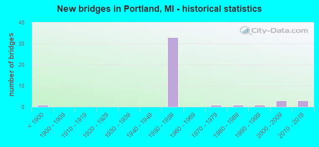
- New bridges - historical statistics
- 1Before 1900
- 331950-1959
- 11970-1979
- 11980-1989
- 11990-1999
- 32000-2009
- 32010-2019

- Reconstructed bridges - Historical Statistics
- 21970-1979
- 01980-1989
- 11990-1999
- 12000-2009


- Bridge Condition - Deck
- 4.2%Very good
- 25.0%Good
- 62.5%Satisfactory
- 4.2%Fair
- 4.2%Poor

- Bridge Condition - Superstructure
- 8.3%Very good
- 25.0%Good
- 41.7%Satisfactory
- 20.8%Fair
- 4.2%Poor

- Bridge Condition - Substructure
- 8.3%Very good
- 37.5%Good
- 33.3%Satisfactory
- 16.7%Fair
- 4.2%Serious

- Bridge Condition - Channel
- 77.8%Good
- 11.1%Satisfactory
- 11.1%Serious
Find on map >> Show street view
Structure Number: 1787, Location: AT IONIA CO LINE (Lat: 42.827011, Lng: -84.837097), Route carried "on" structure: County highway , Year Built: 1958, Year Reconstructed: 2005, Status: Open, Structure Length: 8.56m (28.08ft), Average Daily Traffic: 50 (year 0000), Truck Traffic: 3%, Average Future Daily Traffic: 100 (year 2005), Design Load: H 15, Features Intersected: I-96, Facility Carried by Structure: CLINTONIA RD
Minimum Vertical Clearance: 30.48m (100.00ft), Kilometerpoint: 2.760, Lanes on structure: 2, Lanes under structure: 4, Owner: State Highway Agency, Approaching Roadway Width: 7.9m (25.9ft), Skew: 3 degrees, Material/Design: Concrete continuous, Design/Construction: Tee Beam, Number Of Spans In Main Unit: 4, Length of Maximum Span: 25.3m (83.0ft), Curb-To-Curb Width: 7.9m (25.9ft), Out-to-Out Width: 10.2m (33.5ft)
Condition: Deck: Satisfactory, Superstructure: Fair, Substructure: Satisfactory, Operating Rating: 56.1 metric tons, Method Used To Determine Operating Rating: Load Factor (LF) rating reported by rating factor (RF) method using MS18 loading, Inventory Rating: 33.4 metric tons, Method Used To Determine Inventory Rating: Load Factor (LF) rating reported by rating factor (RF) method using MS18 loading, Structural Evaluation: Somewhat better than minimum adequacy, Deck Geometry: Equal to present minimum criteria, Underclear: Meets minimum limits, Approach Roadway Alignment: Equal to present minimum criteria, Designated Inspection Frequency: Every 24 months, Inspection Date: April 2020, Deck Structure Type: Concrete Cast-file-Place, Wearing Surface/Protective System: Wearing Surface: Latex Concrete, Deck Protection: Epoxy Coated Reinforcing
Find on map >> Show street view
Structure Number: 1976, Location: 0.3 MI N OF HOWE RD (Lat: 42.849347, Lng: -84.828047), Route carried "on" structure: County highway , Year Built: 2001, Status: Open, Structure Length: 4.80m (15.75ft), Average Daily Traffic: 200 (year 2002), Average Future Daily Traffic: 300 (year 2022), Design Load: HS 25 or greater, Features Intersected: LOOKING GLASS RIVER, Facility Carried by Structure: MONROE ROAD
Minimum Vertical Clearance: 30.48m (100.00ft), Kilometerpoint: 0.716, Lanes on structure: 2, Owner: County Highway Agency, Approaching Roadway Width: 5.5m (18.0ft), Skew: 3 degrees, Material/Design: Prestressed concrete, Design/Construction: Box Beam or Girders - Multiple, Number Of Spans In Main Unit: 2, Length of Maximum Span: 33.0m (108.3ft), Curb-To-Curb Width: 9.1m (29.9ft), Out-to-Out Width: 10.1m (33.1ft)
Condition: Deck: Good, Superstructure: Satisfactory, Substructure: Very good, Channel: Good, Inventory Rating: 63.0 metric tons, Method Used To Determine Inventory Rating: Load Factor (LF), Structural Evaluation: Equal to present minimum criteria, Deck Geometry: Equal to present minimum criteria, Waterway Adequacy: Equal to present desirable criteria, Approach Roadway Alignment: Better than present minimum criteria, Designated Inspection Frequency: Every 24 months, Inspection Date: October 2021, Deck Structure Type: Concrete Cast-file-Place, Wearing Surface/Protective System: Wearing Surface: Integral Concrete, Deck Protection: Epoxy Coated Reinforcing
Find on map >> Show street view
Structure Number: 3978, Location: 0.2 MI W OF PORTLAND (Lat: 42.860689, Lng: -84.917125), Route carried "on" structure: Interstate 96, Year Built: 1959, Status: Open, Structure Length: 12.62m (41.40ft), Average Daily Traffic: 14,899 (year 2012), Truck Traffic: 15%, Average Future Daily Traffic: 19,691 (year 2018), Design Load: HS 20, Features Intersected: GRAND RIVER & MARKET RD
Minimum Vertical Clearance: 30.48m (100.00ft), Kilometerpoint: 32.804, Lanes on structure: 2, Lanes under structure: 2, Base Highway Network: Yes (Inventory Route: 50, Subroute: 10), Owner: State Highway Agency, Approaching Roadway Width: 12.8m (42.0ft), Material/Design: Steel continuous, Design/Construction: Girder and Floorbeam System, Number Of Spans In Main Unit: 4, Length of Maximum Span: 39.6m (129.9ft), Curb-To-Curb Width: 10.4m (34.1ft), Out-to-Out Width: 11.4m (37.4ft)
Condition: Deck: Satisfactory, Superstructure: Satisfactory, Substructure: Fair, Channel: Good, Operating Rating: 67.1 metric tons, Method Used To Determine Operating Rating: Load Factor (LF) rating reported by rating factor (RF) method using MS18 loading, Inventory Rating: 40.2 metric tons, Method Used To Determine Inventory Rating: Load Factor (LF) rating reported by rating factor (RF) method using MS18 loading, Structural Evaluation: Somewhat better than minimum adequacy, Deck Geometry: Meets minimum limits, Underclear: Meets minimum limits, Waterway Adequacy: Equal to present desirable criteria, Approach Roadway Alignment: Equal to present desirable criteria, Designated Inspection Frequency: Every 24 months, Critical Feature Inspection Frequency: Every 15 months, Underwater Inspection Frequency: Every 60 months, Inspection Date: December 2020, Critical Feature Inspection Date: September 2021, Underwater Inspection Date: May 2020, Bridge Improvement Cost: $380,000, Deck Structure Type: Concrete Cast-file-Place, Wearing Surface/Protective System: Wearing Surface: Latex Concrete
Find on map >> Show street view
Structure Number: 3979, Location: 0.2 MI W OF PORTLAND (Lat: 42.860858, Lng: -84.917025), Route carried "on" structure: Interstate 96, Year Built: 1959, Status: Open, Structure Length: 12.62m (41.40ft), Average Daily Traffic: 14,899 (year 2012), Truck Traffic: 15%, Average Future Daily Traffic: 19,691 (year 2018), Design Load: HS 20, Features Intersected: GRAND RIVER & MARKET RD
Minimum Vertical Clearance: 30.48m (100.00ft), Kilometerpoint: 32.809, Lanes on structure: 2, Lanes under structure: 2, Base Highway Network: Yes (Inventory Route: 50, Subroute: 6), Owner: State Highway Agency, Approaching Roadway Width: 12.8m (42.0ft), Material/Design: Steel continuous, Design/Construction: Girder and Floorbeam System, Number Of Spans In Main Unit: 4, Length of Maximum Span: 39.6m (129.9ft), Curb-To-Curb Width: 10.4m (34.1ft), Out-to-Out Width: 11.4m (37.4ft)
Condition: Deck: Satisfactory, Superstructure: Fair, Substructure: Fair, Channel: Good, Operating Rating: 71.3 metric tons, Method Used To Determine Operating Rating: Load Factor (LF), Inventory Rating: 42.7 metric tons, Method Used To Determine Inventory Rating: Load Factor (LF), Structural Evaluation: Somewhat better than minimum adequacy, Deck Geometry: Meets minimum limits, Underclear: Meets minimum limits, Waterway Adequacy: Equal to present desirable criteria, Approach Roadway Alignment: Equal to present desirable criteria, Designated Inspection Frequency: Every 24 months, Critical Feature Inspection Frequency: Every 15 months, Underwater Inspection Frequency: Every 60 months, Inspection Date: December 2020, Critical Feature Inspection Date: September 2021, Underwater Inspection Date: May 2020, Bridge Improvement Cost: $380,000, Deck Structure Type: Concrete Cast-file-Place, Wearing Surface/Protective System: Wearing Surface: Latex Concrete
Find on map >> Show street view
Structure Number: 3987, Location: 4.0 MI E OF M-66 (Lat: 42.879172, Lng: -84.995036), Route carried "on" structure: County highway , Year Built: 1959, Status: Open, Structure Length: 7.31m (23.98ft), Average Daily Traffic: 190 (year 1974), Average Future Daily Traffic: 190 (year 1977), Design Load: H 15, Features Intersected: I-96, Facility Carried by Structure: SUNFIELD RD
Minimum Vertical Clearance: 30.48m (100.00ft), Kilometerpoint: 12.024, Lanes on structure: 2, Lanes under structure: 4, Owner: State Highway Agency, Approaching Roadway Width: 12.8m (42.0ft), Material/Design: Concrete continuous, Design/Construction: Tee Beam, Number Of Spans In Main Unit: 4, Length of Maximum Span: 21.6m (70.9ft), Curb or Sidewalk Widths: Left: 0.2m (0.7ft), Right: 0.2m (0.7ft), Curb-To-Curb Width: 7.9m (25.9ft), Out-to-Out Width: 10.1m (33.1ft)
Condition: Deck: Satisfactory, Superstructure: Satisfactory, Substructure: Good, Operating Rating: 45.0 metric tons, Method Used To Determine Operating Rating: Load Factor (LF) rating reported by rating factor (RF) method using MS18 loading, Inventory Rating: 26.9 metric tons, Method Used To Determine Inventory Rating: Load Factor (LF) rating reported by rating factor (RF) method using MS18 loading, Structural Evaluation: Equal to present minimum criteria, Deck Geometry: Somewhat better than minimum adequacy, Underclear: High priority of corrective action, Approach Roadway Alignment: Better than present minimum criteria, Designated Inspection Frequency: Every 24 months, Inspection Date: December 2020, Deck Structure Type: Concrete Cast-file-Place, Wearing Surface/Protective System: Wearing Surface: Epoxy Overlay
Find on map >> Show street view
Structure Number: 3988, Location: 6.0 MI E OF M-66 (Lat: 42.871428, Lng: -84.962986), Route carried "on" structure: Interstate 96, Year Built: 1958, Status: Open, Structure Length: 4.33m (14.21ft), Average Daily Traffic: 19,963 (year 2007), Truck Traffic: 16%, Average Future Daily Traffic: 19,691 (year 2018), Design Load: HS 20, Features Intersected: PORTLAND RD
Minimum Vertical Clearance: 30.48m (100.00ft), Kilometerpoint: 28.816, Lanes on structure: 2, Lanes under structure: 2, Base Highway Network: Yes (Inventory Route: 50, Subroute: 10), Owner: State Highway Agency, Approaching Roadway Width: 12.8m (42.0ft), Skew: 13 degrees, Material/Design: Concrete continuous, Design/Construction: Tee Beam, Number Of Spans In Main Unit: 3, Length of Maximum Span: 16.7m (54.8ft), Curb-To-Curb Width: 12.8m (42.0ft), Out-to-Out Width: 14.4m (47.2ft)
Condition: Deck: Satisfactory, Superstructure: Fair, Substructure: Satisfactory, Operating Rating: 55.7 metric tons, Method Used To Determine Operating Rating: Load Factor (LF) rating reported by rating factor (RF) method using MS18 loading, Inventory Rating: 33.7 metric tons, Method Used To Determine Inventory Rating: Load Factor (LF) rating reported by rating factor (RF) method using MS18 loading, Structural Evaluation: Somewhat better than minimum adequacy, Deck Geometry: Equal to present desirable criteria, Underclear: Meets minimum limits, Approach Roadway Alignment: Better than present minimum criteria, Designated Inspection Frequency: Every 24 months, Inspection Date: December 2020, Deck Structure Type: Concrete Cast-file-Place, Wearing Surface/Protective System: Wearing Surface: Latex Concrete
Find on map >> Show street view
Structure Number: 3989, Location: 6.0 MI E OF M-66 (Lat: 42.871425, Lng: -84.962517), Route carried "on" structure: Interstate 96, Year Built: 1958, Status: Open, Structure Length: 4.32m (14.17ft), Average Daily Traffic: 19,963 (year 2007), Truck Traffic: 16%, Average Future Daily Traffic: 19,691 (year 2018), Design Load: HS 20, Features Intersected: PORTLAND RD
Minimum Vertical Clearance: 30.48m (100.00ft), Kilometerpoint: 28.863, Lanes on structure: 2, Lanes under structure: 2, Base Highway Network: Yes (Inventory Route: 50, Subroute: 6), Owner: State Highway Agency, Approaching Roadway Width: 12.8m (42.0ft), Skew: 13 degrees, Material/Design: Concrete continuous, Design/Construction: Tee Beam, Number Of Spans In Main Unit: 3, Length of Maximum Span: 16.7m (54.8ft), Curb-To-Curb Width: 13.2m (43.3ft), Out-to-Out Width: 14.4m (47.2ft)
Condition: Deck: Satisfactory, Superstructure: Good, Substructure: Satisfactory, Operating Rating: 55.7 metric tons, Method Used To Determine Operating Rating: Load Factor (LF) rating reported by rating factor (RF) method using MS18 loading, Inventory Rating: 33.7 metric tons, Method Used To Determine Inventory Rating: Load Factor (LF) rating reported by rating factor (RF) method using MS18 loading, Structural Evaluation: Equal to present minimum criteria, Deck Geometry: Superior to present desirable criteria, Underclear: Equal to present minimum criteria, Approach Roadway Alignment: Better than present minimum criteria, Designated Inspection Frequency: Every 24 months, Inspection Date: December 2020, Deck Structure Type: Concrete Cast-file-Place, Wearing Surface/Protective System: Wearing Surface: Latex Concrete
Find on map >> Show street view
Structure Number: 399, Location: 6.4 MI E OF M-66 (Lat: 42.866614, Lng: -84.955936), Route carried "on" structure: County highway 3475, Year Built: 1958, Status: Posted for load, Structure Length: 8.46m (27.76ft), Average Daily Traffic: 320 (year 1974), Average Future Daily Traffic: 320 (year 1977), Design Load: H 15, Features Intersected: I-96, Facility Carried by Structure: KEEFER RD
Minimum Vertical Clearance: 30.48m (100.00ft), Kilometerpoint: 10.678, Lanes on structure: 2, Lanes under structure: 4, Owner: State Highway Agency, Approaching Roadway Width: 10.3m (33.8ft), Skew: 3 degrees, Material/Design: Concrete continuous, Design/Construction: Tee Beam, Number Of Spans In Main Unit: 4, Length of Maximum Span: 25.0m (82.0ft), Curb-To-Curb Width: 9.2m (30.2ft), Out-to-Out Width: 10.1m (33.1ft)
Condition: Deck: Satisfactory, Superstructure: Satisfactory, Substructure: Good, Operating Rating: 38.2 metric tons, Method Used To Determine Operating Rating: Load Factor (LF) rating reported by rating factor (RF) method using MS18 loading, Inventory Rating: 23.0 metric tons, Method Used To Determine Inventory Rating: Load Factor (LF) rating reported by rating factor (RF) method using MS18 loading, Structural Evaluation: Equal to present minimum criteria, Deck Geometry: Equal to present minimum criteria, Underclear: Meets minimum limits, Approach Roadway Alignment: Equal to present minimum criteria, Bridge Posting: Required (Relationship of Operating Rating to Maximum Legal Load: 10.0 - 19.9% below), Designated Inspection Frequency: Every 24 months, Inspection Date: December 2020, Deck Structure Type: Concrete Cast-file-Place, Wearing Surface/Protective System: Wearing Surface: Epoxy Overlay
Find on map >> Show street view
Structure Number: 3991, Location: 0.3 MI W OF PORTLAND (Lat: 42.861975, Lng: -84.922225), Route carried "on" structure: County highway , Year Built: 1959, Status: Open, Structure Length: 7.65m (25.10ft), Average Daily Traffic: 530 (year 1974), Average Future Daily Traffic: 530 (year 1977), Design Load: H 15, Features Intersected: I-96, Facility Carried by Structure: KNOX RD
Minimum Vertical Clearance: 30.48m (100.00ft), Kilometerpoint: 6.161, Lanes on structure: 2, Lanes under structure: 4, Owner: State Highway Agency, Approaching Roadway Width: 10.3m (33.8ft), Skew: 2 degrees, Material/Design: Concrete continuous, Design/Construction: Tee Beam, Number Of Spans In Main Unit: 4, Length of Maximum Span: 21.6m (70.9ft), Curb-To-Curb Width: 9.1m (29.9ft), Out-to-Out Width: 10.1m (33.1ft)
Condition: Deck: Satisfactory, Superstructure: Satisfactory, Substructure: Satisfactory, Operating Rating: 31.1 metric tons, Method Used To Determine Operating Rating: Load and Resistance Factor Rating (LRFR) rating reported by rating factor(RF) method using HL-93 loadings, Inventory Rating: 22.4 metric tons, Method Used To Determine Inventory Rating: Load and Resistance Factor Rating (LRFR) rating reported by rating factor(RF) method using HL-93 loadings, Structural Evaluation: Somewhat better than minimum adequacy, Deck Geometry: Equal to present minimum criteria, Underclear: High priority of corrective action, Approach Roadway Alignment: Equal to present desirable criteria, Designated Inspection Frequency: Every 24 months, Inspection Date: December 2020, Deck Structure Type: Concrete Cast-file-Place, Wearing Surface/Protective System: Wearing Surface: Epoxy Overlay
Find on map >> Show street view
Structure Number: 3992, Location: S LTS OF PORTLAND (Lat: 42.860056, Lng: -84.912228), Route carried "on" structure: Interstate 96, Year Built: 1959, Status: Open, Structure Length: 4.42m (14.50ft), Average Daily Traffic: 20,074 (year 2007), Truck Traffic: 15%, Average Future Daily Traffic: 19,274 (year 2018), Design Load: HS 20, Features Intersected: KENT RD
Minimum Vertical Clearance: 30.48m (100.00ft), Kilometerpoint: 33.290, Lanes on structure: 2, Lanes under structure: 2, Base Highway Network: Yes (Inventory Route: 50, Subroute: 10), Owner: State Highway Agency, Approaching Roadway Width: 12.8m (42.0ft), Skew: 13 degrees, Material/Design: Concrete continuous, Design/Construction: Tee Beam, Number Of Spans In Main Unit: 3, Length of Maximum Span: 17.0m (55.8ft), Curb-To-Curb Width: 13.2m (43.3ft), Out-to-Out Width: 14.4m (47.2ft)
Condition: Deck: Satisfactory, Superstructure: Satisfactory, Substructure: Satisfactory, Operating Rating: 64.5 metric tons, Method Used To Determine Operating Rating: Load Factor (LF) rating reported by rating factor (RF) method using MS18 loading, Inventory Rating: 38.2 metric tons, Method Used To Determine Inventory Rating: Load Factor (LF) rating reported by rating factor (RF) method using MS18 loading, Structural Evaluation: Equal to present minimum criteria, Deck Geometry: Superior to present desirable criteria, Underclear: High priority of corrective action, Approach Roadway Alignment: Equal to present desirable criteria, Designated Inspection Frequency: Every 24 months, Inspection Date: December 2020, Deck Structure Type: Concrete Cast-file-Place, Wearing Surface/Protective System: Wearing Surface: Latex Concrete
Find on map >> Show street view
Structure Number: 3993, Location: S LTS OF PORTLAND (Lat: 42.860242, Lng: -84.912039), Route carried "on" structure: Interstate 96, Year Built: 1959, Status: Open, Structure Length: 4.48m (14.70ft), Average Daily Traffic: 20,074 (year 2007), Truck Traffic: 15%, Average Future Daily Traffic: 19,274 (year 2018), Design Load: HS 20, Features Intersected: KENT RD
Minimum Vertical Clearance: 30.48m (100.00ft), Kilometerpoint: 33.303, Lanes on structure: 2, Lanes under structure: 2, Base Highway Network: Yes (Inventory Route: 50, Subroute: 6), Owner: State Highway Agency, Approaching Roadway Width: 12.8m (42.0ft), Skew: 13 degrees, Material/Design: Concrete continuous, Design/Construction: Tee Beam, Number Of Spans In Main Unit: 3, Length of Maximum Span: 17.3m (56.8ft), Curb-To-Curb Width: 12.8m (42.0ft), Out-to-Out Width: 14.4m (47.2ft)
Condition: Deck: Satisfactory, Superstructure: Satisfactory, Substructure: Fair, Operating Rating: 64.5 metric tons, Method Used To Determine Operating Rating: Load Factor (LF) rating reported by rating factor (RF) method using MS18 loading, Inventory Rating: 38.2 metric tons, Method Used To Determine Inventory Rating: Load Factor (LF) rating reported by rating factor (RF) method using MS18 loading, Structural Evaluation: Somewhat better than minimum adequacy, Deck Geometry: Equal to present desirable criteria, Underclear: High priority of corrective action, Approach Roadway Alignment: Equal to present desirable criteria, Designated Inspection Frequency: Every 24 months, Inspection Date: December 2020, Deck Structure Type: Concrete Cast-file-Place, Wearing Surface/Protective System: Wearing Surface: Latex Concrete
Find on map >> Show street view
Structure Number: 3994, Location: S LTS OF PORTLAND (Lat: 42.860967, Lng: -84.901775), Route carried "on" structure: Interstate 96, Year Built: 1959, Status: Open, Structure Length: 3.53m (11.58ft), Average Daily Traffic: 20,074 (year 2007), Truck Traffic: 15%, Average Future Daily Traffic: 19,274 (year 2018), Design Load: HS 20, Features Intersected: OKEMOS RD
Minimum Vertical Clearance: 30.48m (100.00ft), Kilometerpoint: 34.156, Lanes on structure: 2, Lanes under structure: 2, Base Highway Network: Yes (Inventory Route: 50, Subroute: 10), Owner: State Highway Agency, Approaching Roadway Width: 12.8m (42.0ft), Skew: 11 degrees, Material/Design: Concrete continuous, Design/Construction: Tee Beam, Number Of Spans In Main Unit: 3, Length of Maximum Span: 13.7m (44.9ft), Curb-To-Curb Width: 12.8m (42.0ft), Out-to-Out Width: 14.4m (47.2ft)
Condition: Deck: Satisfactory, Superstructure: Good, Substructure: Good, Operating Rating: 69.3 metric tons, Method Used To Determine Operating Rating: Load Factor (LF) rating reported by rating factor (RF) method using MS18 loading, Inventory Rating: 41.8 metric tons, Method Used To Determine Inventory Rating: Load Factor (LF) rating reported by rating factor (RF) method using MS18 loading, Structural Evaluation: Better than present minimum criteria, Deck Geometry: Equal to present desirable criteria, Underclear: Meets minimum limits, Approach Roadway Alignment: Better than present minimum criteria, Designated Inspection Frequency: Every 24 months, Inspection Date: December 2020, Deck Structure Type: Concrete Cast-file-Place, Wearing Surface/Protective System: Wearing Surface: Latex Concrete
Find on map >> Show street view
Structure Number: 3995, Location: S LTS OF PORTLAND (Lat: 42.861186, Lng: -84.901811), Route carried "on" structure: Interstate 96, Year Built: 1959, Status: Open, Structure Length: 3.53m (11.58ft), Average Daily Traffic: 20,074 (year 2007), Truck Traffic: 15%, Average Future Daily Traffic: 19,274 (year 2018), Design Load: HS 20, Features Intersected: OKEMOS RD
Minimum Vertical Clearance: 30.48m (100.00ft), Kilometerpoint: 34.150, Lanes on structure: 2, Lanes under structure: 2, Base Highway Network: Yes (Inventory Route: 50, Subroute: 6), Owner: State Highway Agency, Approaching Roadway Width: 12.8m (42.0ft), Skew: 11 degrees, Material/Design: Concrete continuous, Design/Construction: Tee Beam, Number Of Spans In Main Unit: 3, Length of Maximum Span: 13.7m (44.9ft), Curb-To-Curb Width: 12.8m (42.0ft), Out-to-Out Width: 14.4m (47.2ft)
Condition: Deck: Good, Superstructure: Good, Substructure: Satisfactory, Operating Rating: 60.6 metric tons, Method Used To Determine Operating Rating: Load Factor (LF) rating reported by rating factor (RF) method using MS18 loading, Inventory Rating: 36.6 metric tons, Method Used To Determine Inventory Rating: Load Factor (LF) rating reported by rating factor (RF) method using MS18 loading, Structural Evaluation: Equal to present minimum criteria, Deck Geometry: Equal to present desirable criteria, Underclear: Meets minimum limits, Approach Roadway Alignment: Better than present minimum criteria, Designated Inspection Frequency: Every 24 months, Inspection Date: December 2020, Deck Structure Type: Concrete Cast-file-Place, Wearing Surface/Protective System: Wearing Surface: Latex Concrete
Find on map >> Show street view
Structure Number: 3996, Location: S LTS OF PORTLAND (Lat: 42.860186, Lng: -84.891347), Route carried "on" structure: Interstate 96, Year Built: 1959, Status: Open, Structure Length: 3.32m (10.89ft), Average Daily Traffic: 20,074 (year 2007), Truck Traffic: 15%, Average Future Daily Traffic: 19,274 (year 2018), Design Load: HS 20, Features Intersected: CHARLOTTE HWY
Minimum Vertical Clearance: 30.48m (100.00ft), Kilometerpoint: 35.012, Lanes on structure: 2, Lanes under structure: 2, Base Highway Network: Yes (Inventory Route: 50, Subroute: 10), Owner: State Highway Agency, Approaching Roadway Width: 12.8m (42.0ft), Skew: 10 degrees, Material/Design: Concrete continuous, Design/Construction: Tee Beam, Number Of Spans In Main Unit: 3, Length of Maximum Span: 12.8m (42.0ft), Curb-To-Curb Width: 13.2m (43.3ft), Out-to-Out Width: 14.4m (47.2ft)
Condition: Deck: Satisfactory, Superstructure: Good, Substructure: Fair, Operating Rating: 64.5 metric tons, Method Used To Determine Operating Rating: Load Factor (LF) rating reported by rating factor (RF) method using MS18 loading, Inventory Rating: 38.9 metric tons, Method Used To Determine Inventory Rating: Load Factor (LF) rating reported by rating factor (RF) method using MS18 loading, Structural Evaluation: Somewhat better than minimum adequacy, Deck Geometry: Superior to present desirable criteria, Underclear: High priority of corrective action, Approach Roadway Alignment: Better than present minimum criteria, Designated Inspection Frequency: Every 24 months, Inspection Date: December 2020, Deck Structure Type: Concrete Cast-file-Place, Wearing Surface/Protective System: Wearing Surface: Latex Concrete
Find on map >> Show street view
Structure Number: 3998, Location: E LTS OF PORTLAND (Lat: 42.859653, Lng: -84.884447), Route carried "on" structure: Interstate 96, Year Built: 1959, Year Reconstructed: 1984, Status: Open, Structure Length: 4.61m (15.12ft), Average Daily Traffic: 20,074 (year 2007), Truck Traffic: 14%, Average Future Daily Traffic: 23,477 (year 2018), Design Load: HS 20, Features Intersected: GRAND RIVER AVE
Minimum Vertical Clearance: 30.48m (100.00ft), Kilometerpoint: 35.579, Lanes on structure: 3, Lanes under structure: 3, Base Highway Network: Yes (Inventory Route: 50, Subroute: 10), Owner: State Highway Agency, Approaching Roadway Width: 12.8m (42.0ft), Skew: 13 degrees, Material/Design: Steel, Design/Construction: Stringer/Multi-beam, Number Of Spans In Main Unit: 3, Length of Maximum Span: 19.9m (65.3ft), Curb-To-Curb Width: 15.8m (51.8ft), Out-to-Out Width: 17.5m (57.4ft)
Condition: Deck: Satisfactory, Superstructure: Satisfactory, Substructure: Good, Operating Rating: 70.6 metric tons, Method Used To Determine Operating Rating: Load Factor (LF) rating reported by rating factor (RF) method using MS18 loading, Inventory Rating: 42.4 metric tons, Method Used To Determine Inventory Rating: Load Factor (LF) rating reported by rating factor (RF) method using MS18 loading, Structural Evaluation: Equal to present minimum criteria, Deck Geometry: Somewhat better than minimum adequacy, Underclear: Meets minimum limits, Approach Roadway Alignment: Equal to present desirable criteria, Designated Inspection Frequency: Every 24 months, Inspection Date: December 2020, Bridge Improvement Cost: $143,000, Deck Structure Type: Concrete Cast-file-Place, Wearing Surface/Protective System: Wearing Surface: Latex Concrete
Find on map >> Show street view
Structure Number: 3999, Location: E LTS OF PORTLAND (Lat: 42.859900, Lng: -84.884639), Route carried "on" structure: Interstate 96, Year Built: 1959, Year Reconstructed: 1984, Status: Open, Structure Length: 4.61m (15.12ft), Average Daily Traffic: 20,074 (year 2007), Truck Traffic: 14%, Average Future Daily Traffic: 23,477 (year 2018), Design Load: HS 20, Features Intersected: GRAND RIVER AVE
Minimum Vertical Clearance: 30.48m (100.00ft), Kilometerpoint: 35.560, Lanes on structure: 2, Lanes under structure: 3, Base Highway Network: Yes (Inventory Route: 50, Subroute: 6), Owner: State Highway Agency, Approaching Roadway Width: 12.8m (42.0ft), Skew: 13 degrees, Material/Design: Steel, Design/Construction: Stringer/Multi-beam, Number Of Spans In Main Unit: 3, Length of Maximum Span: 19.8m (65.0ft), Curb-To-Curb Width: 12.8m (42.0ft), Out-to-Out Width: 14.4m (47.2ft)
Condition: Deck: Good, Superstructure: Good, Substructure: Good, Operating Rating: 67.1 metric tons, Method Used To Determine Operating Rating: Load Factor (LF) rating reported by rating factor (RF) method using MS18 loading, Inventory Rating: 40.2 metric tons, Method Used To Determine Inventory Rating: Load Factor (LF) rating reported by rating factor (RF) method using MS18 loading, Structural Evaluation: Better than present minimum criteria, Deck Geometry: Equal to present desirable criteria, Underclear: Meets minimum limits, Approach Roadway Alignment: Equal to present desirable criteria, Designated Inspection Frequency: Every 24 months, Inspection Date: November 2021, Deck Structure Type: Concrete Cast-file-Place, Wearing Surface/Protective System: Wearing Surface: Latex Concrete
Find on map >> Show street view
Structure Number: 4, Location: 2.9 MI NW OF CLINTON COL (Lat: 42.857189, Lng: -84.870367), Route carried "on" structure: County highway , Year Built: 2019, Status: Open, Structure Length: 9.57m (31.40ft), Average Daily Traffic: 830 (year 2017), Average Future Daily Traffic: 925 (year 2039), Design Load: Greater than HL93, Features Intersected: I-96, Facility Carried by Structure: CUTLER RD
Minimum Vertical Clearance: 30.48m (100.00ft), Kilometerpoint: 1.666, Lanes on structure: 2, Lanes under structure: 4, Owner: State Highway Agency, Approaching Roadway Width: 11.0m (36.1ft), Skew: 3 degrees, Material/Design: Steel continuous, Design/Construction: Stringer/Multi-beam, Number Of Spans In Main Unit: 2, Length of Maximum Span: 47.3m (155.2ft), Curb-To-Curb Width: 9.8m (32.2ft), Out-to-Out Width: 10.8m (35.4ft)
Condition: Deck: Very good, Superstructure: Very good, Substructure: Very good, Operating Rating: 51.8 metric tons, Method Used To Determine Operating Rating: Load and Resistance Factor Rating (LRFR) rating reported by rating factor(RF) method using HL-93 loadings, Inventory Rating: 39.9 metric tons, Method Used To Determine Inventory Rating: Load and Resistance Factor Rating (LRFR) rating reported by rating factor(RF) method using HL-93 loadings, Structural Evaluation: Equal to present desirable criteria, Deck Geometry: Equal to present minimum criteria, Underclear: Equal to present minimum criteria, Approach Roadway Alignment: Equal to present minimum criteria, Designated Inspection Frequency: Every 24 months, Inspection Date: December 2020, Bridge Improvement Cost: $122,000, Deck Structure Type: Concrete Cast-file-Place, Wearing Surface/Protective System: Wearing Surface: Monolithic Concrete, Deck Protection: Epoxy Coated Reinforcing
Find on map >> Show street view
Structure Number: 4001, Location: 1.4 MI NW OF CLINTON COL (Lat: 42.842794, Lng: -84.848478), Route carried "on" structure: County highway , Year Built: 1958, Status: Open, Structure Length: 9.10m (29.86ft), Average Daily Traffic: 200 (year 1974), Average Future Daily Traffic: 200 (year 1977), Design Load: H 15, Features Intersected: I-96, Facility Carried by Structure: PEAKE RD
Minimum Vertical Clearance: 30.48m (100.00ft), Kilometerpoint: 4.011, Lanes on structure: 2, Lanes under structure: 4, Owner: State Highway Agency, Approaching Roadway Width: 9.7m (31.8ft), Skew: 3 degrees, Material/Design: Concrete continuous, Design/Construction: Tee Beam, Number Of Spans In Main Unit: 4, Length of Maximum Span: 27.4m (89.9ft), Curb or Sidewalk Widths: Left: 0.7m (2.3ft), Right: 0.7m (2.3ft), Curb-To-Curb Width: 7.9m (25.9ft), Out-to-Out Width: 10.2m (33.5ft)
Condition: Deck: Satisfactory, Superstructure: Fair, Substructure: Satisfactory, Operating Rating: 58.6 metric tons, Method Used To Determine Operating Rating: Load Factor (LF) rating reported by rating factor (RF) method using MS18 loading, Inventory Rating: 35.3 metric tons, Method Used To Determine Inventory Rating: Load Factor (LF) rating reported by rating factor (RF) method using MS18 loading, Structural Evaluation: Somewhat better than minimum adequacy, Deck Geometry: Somewhat better than minimum adequacy, Underclear: Somewhat better than minimum adequacy, Approach Roadway Alignment: Better than present minimum criteria, Designated Inspection Frequency: Every 24 months, Inspection Date: December 2020, Deck Structure Type: Concrete Cast-file-Place, Wearing Surface/Protective System: Wearing Surface: Latex Concrete
Find on map >> Show street view
Structure Number: 4016, Location: KENT ST S PORTLD VILL LMT (Lat: 42.856614, Lng: -84.911958), Route carried "on" structure: ServiceCounty highway 3422, Year Built: 2002, Status: Open, Structure Length: 7.43m (24.38ft), Average Daily Traffic: 1,222 (year 2013), Truck Traffic: 8%, Average Future Daily Traffic: 1,491 (year 2033), Design Load: HS 25 or greater, Features Intersected: GRAND RIVER, Facility Carried by Structure: KENT STREET
Minimum Vertical Clearance: 30.48m (100.00ft), Kilometerpoint: 7.389, Lanes on structure: 2, Owner: County Highway Agency, Approaching Roadway Width: 9.1m (29.9ft), Material/Design: Prestressed concrete, Design/Construction: Stringer/Multi-beam, Number Of Spans In Main Unit: 2, Length of Maximum Span: 37.1m (121.7ft), Curb-To-Curb Width: 11.9m (39.0ft), Out-to-Out Width: 12.7m (41.7ft)
Condition: Deck: Good, Superstructure: Very good, Substructure: Good, Channel: Good, Operating Rating: 97.2 metric tons, Method Used To Determine Operating Rating: Load Factor (LF) rating reported by rating factor (RF) method using MS18 loading, Inventory Rating: 81.6 metric tons, Method Used To Determine Inventory Rating: Load Factor (LF) rating reported by rating factor (RF) method using MS18 loading, Structural Evaluation: Better than present minimum criteria, Deck Geometry: Equal to present minimum criteria, Waterway Adequacy: Equal to present desirable criteria, Approach Roadway Alignment: Somewhat better than minimum adequacy, Designated Inspection Frequency: Every 24 months, Inspection Date: October 2021, Deck Structure Type: Concrete Cast-file-Place, Wearing Surface/Protective System: Wearing Surface: Monolithic Concrete, Deck Protection: Epoxy Coated Reinforcing
Find on map >> Show street view
Structure Number: 4046, Location: 3 MI S VILL LIMITS PORT]D (Lat: 42.815700, Lng: -84.894661), Route carried "on" structure: ServiceCounty highway 3487, Year Built: 2001, Status: Open, Structure Length: 12.60m (41.34ft), Average Daily Traffic: 510 (year 2013), Truck Traffic: 10%, Average Future Daily Traffic: 622 (year 2033), Design Load: HS 20+Mod, Features Intersected: GRAND RIVER, Facility Carried by Structure: CHARLOTTE HIGHWAY
Minimum Vertical Clearance: 30.48m (100.00ft), Kilometerpoint: 3.764, Lanes on structure: 2, Owner: County Highway Agency, Approaching Roadway Width: 11.9m (39.0ft), Skew: 1 degrees, Material/Design: Prestressed concrete, Design/Construction: Box Beam or Girders - Single/Spread, Number Of Spans In Main Unit: 4, Length of Maximum Span: 36.0m (118.1ft), Curb-To-Curb Width: 11.9m (39.0ft), Out-to-Out Width: 12.9m (42.3ft)
Condition: Deck: Good, Superstructure: Satisfactory, Substructure: Good, Channel: Satisfactory, Operating Rating: 92.7 metric tons, Method Used To Determine Operating Rating: Load Factor (LF) rating reported by rating factor (RF) method using MS18 loading, Inventory Rating: 45.7 metric tons, Method Used To Determine Inventory Rating: Load Factor (LF) rating reported by rating factor (RF) method using MS18 loading, Structural Evaluation: Equal to present minimum criteria, Deck Geometry: Better than present minimum criteria, Waterway Adequacy: Better than present minimum criteria, Approach Roadway Alignment: Somewhat better than minimum adequacy, Designated Inspection Frequency: Every 24 months, Inspection Date: October 2021, Deck Structure Type: Concrete Cast-file-Place, Wearing Surface/Protective System: Wearing Surface: Monolithic Concrete, Deck Protection: Epoxy Coated Reinforcing
Find on map >> Show street view
Structure Number: 406, Location: 2.0 MILES E OF PORTLAND (Lat: 42.857214, Lng: -84.848672), Route carried "on" structure: ServiceCounty highway , Year Built: 1980, Status: Posted for load, Structure Length: 5.09m (16.70ft), Average Daily Traffic: 711 (year 2016), Truck Traffic: 4%, Average Future Daily Traffic: 768 (year 2036), Design Load: HS 20+Mod, Features Intersected: LOOKING GLASS RIVER, Facility Carried by Structure: CUTLER ROAD
Minimum Vertical Clearance: 30+ m (98+ ft), Kilometerpoint: 3.484, Lanes on structure: 2, Owner: County Highway Agency, Approaching Roadway Width: 9.1m (29.9ft), Skew: 2 degrees, Material/Design: Wood or Timber, Design/Construction: Slab, Number Of Spans In Main Unit: 6, Length of Maximum Span: 9.7m (31.8ft), Curb-To-Curb Width: 9.1m (29.9ft), Out-to-Out Width: 9.6m (31.5ft)
Condition: Deck: Fair, Superstructure: Fair, Substructure: Satisfactory, Channel: Good, Operating Rating: 29.8 metric tons, Method Used To Determine Operating Rating: Allowable Stress (AS) rating reported by rating factor (RF) method using MS18 loading, Inventory Rating: 19.4 metric tons, Method Used To Determine Inventory Rating: Allowable Stress (AS) rating reported by rating factor (RF) method using MS18 loading, Structural Evaluation: Somewhat better than minimum adequacy, Deck Geometry: Equal to present minimum criteria, Waterway Adequacy: Better than present minimum criteria, Approach Roadway Alignment: Better than present minimum criteria, Bridge Posting: Required (Relationship of Operating Rating to Maximum Legal Load: > 39.9% below), Designated Inspection Frequency: Every 24 months, Inspection Date: October 2020, Deck Structure Type: Wood or Timber, Wearing Surface/Protective System: Wearing Surface: Bituminous
Find on map >> Show street view
Structure Number: 4103, Location: 100 FT WEST OF BUSINESS D (Lat: 42.869661, Lng: -84.903800), Route carried "on" structure: City street , Year Built: 1890, Year Reconstructed: 1990, Status: Posted for load, Structure Length: 6.40m (21.00ft), Average Daily Traffic: 1,100 (year 1998), Average Future Daily Traffic: 1,400 (year 2010), Design Load: HS 15, Features Intersected: GRAND RIVER, Facility Carried by Structure: BRIDGE STREET
Minimum Vertical Clearance: 30.48m (100.00ft), Kilometerpoint: 0.267, Lanes on structure: 1, Owner: City or Municipal Highway Agency, Approaching Roadway Width: 4.9m (16.1ft), Material/Design: Steel, Design/Construction: Truss - Thru, Number Of Spans In Main Unit: 2, Length of Maximum Span: 32.0m (105.0ft), Curb or Sidewalk Widths: Left: 1.8m (5.9ft), Right: 0.0m, Curb-To-Curb Width: 4.6m (15.1ft), Out-to-Out Width: 5.4m (17.7ft)
Condition: Deck: Good, Superstructure: Satisfactory, Substructure: Good, Channel: Good, Operating Rating: 40.5 metric tons, Method Used To Determine Operating Rating: Load Factor (LF) rating reported by rating factor (RF) method using MS18 loading, Inventory Rating: 18.5 metric tons, Method Used To Determine Inventory Rating: Load Factor (LF) rating reported by rating factor (RF) method using MS18 loading, Structural Evaluation: Somewhat better than minimum adequacy, Deck Geometry: High priority of replacement, Waterway Adequacy: Equal to present desirable criteria, Approach Roadway Alignment: Equal to present minimum criteria, Bridge Posting: Required (Relationship of Operating Rating to Maximum Legal Load: > 39.9% below), Designated Inspection Frequency: Every 24 months, Critical Feature Inspection Frequency: Every 24 months, Inspection Date: August 2020, Critical Feature Inspection Date: August 2020, Deck Structure Type: Open Grating, Wearing Surface/Protective System: Wearing Surface: Other, Deck Protection: Galvanized Reinforcing
Find on map >> Show street view
Structure Number: 4104, Location: 0.05 MI N OF OLD US16 POR (Lat: 42.870339, Lng: -84.900061), Route carried "on" structure: City street 3487, Year Built: 1979, Status: Posted for load, Structure Length: 2.92m (9.58ft), Average Daily Traffic: 2,494 (year 2010), Truck Traffic: 10%, Average Future Daily Traffic: 3,500 (year 2025), Design Load: HS 20+Mod, Features Intersected: LOOKINGGLASS RIVER, Facility Carried by Structure: DIVINE HIGHWAY
Minimum Vertical Clearance: 30.48m (100.00ft), Kilometerpoint: 0.050, Lanes on structure: 2, Owner: City or Municipal Highway Agency, Approaching Roadway Width: 9.8m (32.2ft), Skew: 2 degrees, Material/Design: Concrete, Design/Construction: Box Beam or Girders - Multiple, Number Of Spans In Main Unit: 2, Length of Maximum Span: 14.6m (47.9ft), Curb or Sidewalk Widths: Left: 1.5m (4.9ft), Right: 1.5m (4.9ft), Curb-To-Curb Width: 9.8m (32.2ft), Out-to-Out Width: 13.5m (44.3ft)
Condition: Deck: Poor, Superstructure: Poor, Substructure: Serious, Channel: Serious, Operating Rating: 31.7 metric tons, Method Used To Determine Operating Rating: Field evaluation and documented engineering judgment, Inventory Rating: 20.9 metric tons, Method Used To Determine Inventory Rating: Field evaluation and documented engineering judgment, Structural Evaluation: High priority of corrective action, Deck Geometry: Meets minimum limits, Waterway Adequacy: Equal to present desirable criteria, Approach Roadway Alignment: Equal to present desirable criteria, Bridge Posting: Required (Relationship of Operating Rating to Maximum Legal Load: 30.0 - 39.9% below), Designated Inspection Frequency: Every 12 months, Inspection Date: August 2021, Deck Structure Type: Concrete Cast-file-Place, Wearing Surface/Protective System: Wearing Surface: Bituminous
Find on map >> Show street view
Structure Number: 4105, Location: 100 FT WEST OF BUSINESS D (Lat: 42.870650, Lng: -84.902797), Route carried "on" structure: City street 3426, Year Built: 1994, Status: Open, Structure Length: 6.00m (19.69ft), Average Daily Traffic: 6,900 (year 1994), Truck Traffic: 5%, Average Future Daily Traffic: 10,250 (year 2012), Design Load: HS 25 or greater, Features Intersected: GRAND RIVER, Facility Carried by Structure: W GRAND RIVER AVE
Minimum Vertical Clearance: 30.48m (100.00ft), Kilometerpoint: 4.716, Lanes on structure: 4, Owner: City or Municipal Highway Agency, Approaching Roadway Width: 14.6m (47.9ft), Material/Design: Prestressed concrete, Design/Construction: Box Beam or Girders - Multiple, Number Of Spans In Main Unit: 3, Length of Maximum Span: 20.1m (65.9ft), Curb or Sidewalk Widths: Left: 2.4m (7.9ft), Right: 2.4m (7.9ft), Curb-To-Curb Width: 14.6m (47.9ft), Out-to-Out Width: 20.3m (66.6ft)
Condition: Deck: Satisfactory, Superstructure: Good, Substructure: Good, Channel: Good, Operating Rating: 57.3 metric tons, Method Used To Determine Operating Rating: Load and Resistance Factor Rating (LRFR) rating reported by rating factor(RF) method using HL-93 loadings, Inventory Rating: 44.4 metric tons, Method Used To Determine Inventory Rating: Load and Resistance Factor Rating (LRFR) rating reported by rating factor(RF) method using HL-93 loadings, Structural Evaluation: Better than present minimum criteria, Deck Geometry: High priority of replacement, Waterway Adequacy: Equal to present desirable criteria, Approach Roadway Alignment: Equal to present desirable criteria, Designated Inspection Frequency: Every 24 months, Inspection Date: August 2020, Deck Structure Type: Concrete Cast-file-Place, Wearing Surface/Protective System: Wearing Surface: Monolithic Concrete, Deck Protection: Epoxy Coated Reinforcing
Find on map >> Show street view
Structure Number: 13392, Location: 1.0 M SE OF PORTLAND (Lat: 42.859533, Lng: -84.882222), Route carried "on" structure: Interstate 96, Year Built: 2013, Status: Open, Structure Length: 0.86m (2.82ft), Average Daily Traffic: 35,000 (year 2010), Truck Traffic: 12%, Average Future Daily Traffic: 42,381 (year 2032), Design Load: Greater than HL93, Features Intersected: PORTLAND TRAIL
Minimum Vertical Clearance: 30.48m (100.00ft), Kilometerpoint: 35.766, Lanes on structure: 6, Base Highway Network: Yes (Inventory Route: 50, Subroute: 10), Owner: State Highway Agency, Approaching Roadway Width: 29.3m (96.1ft), Skew: 3 degrees, Material/Design: Concrete, Design/Construction: Culvert, Number Of Spans In Main Unit: 1, Length of Maximum Span: 7.7m (25.3ft), Curb-To-Curb Width: 21.9m (71.9ft), Out-to-Out Width: 77.7m (254.9ft)
Condition: Culverts: Good, Operating Rating: 97.2 metric tons, Method Used To Determine Operating Rating: Load and Resistance Factor Rating (LRFR) rating reported by rating factor(RF) method using HL-93 loadings, Inventory Rating: 89.7 metric tons, Method Used To Determine Inventory Rating: Load and Resistance Factor Rating (LRFR) rating reported by rating factor(RF) method using HL-93 loadings, Structural Evaluation: Better than present minimum criteria, Deck Geometry: High priority of replacement, Approach Roadway Alignment: Equal to present desirable criteria, Designated Inspection Frequency: Every 24 months, Inspection Date: March 2021
Find on map >> Show street view
Structure Number: 1787, Location: AT IONIA CO LINE (Lat: 42.827011, Lng: -84.837097), Route carried "under" structure: Interstate 96, Year Built: 1958, Structure Length: 0. m, Average Daily Traffic: 35,624 (year 2007), Truck Traffic: 17%, Features Intersected: I-96, Facility Carried by Structure: CLINTONIA RD
Minimum Vertical Clearance: 5.26m (17.26ft), Kilometerpoint: 41.178, Lanes on structure: 2, Lanes under structure: 4, Material/Design: Concrete continuous, Design/Construction: Tee Beam, Length of Maximum Span: 25.3m (83.0ft)
Find on map >> Show street view
Structure Number: 3978, Location: 0.2 MI W OF PORTLAND (Lat: 42.860689, Lng: -84.917125), Route carried "under" structure: County highway , Year Built: 1959, Structure Length: 0. m, Average Daily Traffic: 500 (year 0000), Features Intersected: GRAND RIVER & MARKET RD, Facility Carried by Structure: I-96 EB
Minimum Vertical Clearance: 5.39m (17.68ft), Kilometerpoint: 1.370, Lanes on structure: 2, Lanes under structure: 2, Material/Design: Steel continuous, Design/Construction: Girder and Floorbeam System, Length of Maximum Span: 39.6m (129.9ft)
Find on map >> Show street view
Structure Number: 3979, Location: 0.2 MI W OF PORTLAND (Lat: 42.860858, Lng: -84.917025), Route carried "under" structure: County highway , Year Built: 1959, Structure Length: 0. m, Average Daily Traffic: 500 (year 0000), Features Intersected: GRAND RIVER & MARKET RD, Facility Carried by Structure: I-96 WB
Minimum Vertical Clearance: 5.36m (17.59ft), Kilometerpoint: 1.397, Lanes on structure: 2, Lanes under structure: 2, Material/Design: Steel continuous, Design/Construction: Girder and Floorbeam System, Length of Maximum Span: 39.6m (129.9ft)
Find on map >> Show street view
Structure Number: 3987, Location: 4.0 MI E OF M-66 (Lat: 42.879172, Lng: -84.995036), Route carried "under" structure: Interstate 96, Year Built: 1959, Structure Length: 0. m, Average Daily Traffic: 33,978 (year 2007), Truck Traffic: 13%, Features Intersected: I-96, Facility Carried by Structure: SUNFIELD RD
Minimum Vertical Clearance: 4.65m (15.26ft), Kilometerpoint: 25.916, Lanes on structure: 2, Lanes under structure: 4, Material/Design: Concrete continuous, Design/Construction: Tee Beam, Length of Maximum Span: 21.6m (70.9ft)
Find on map >> Show street view
Structure Number: 3988, Location: 6.0 MI E OF M-66 (Lat: 42.871428, Lng: -84.962986), Route carried "under" structure: County highway 3426, Year Built: 1958, Structure Length: 0. m, Average Daily Traffic: 310 (year 1974), Features Intersected: PORTLAND RD, Facility Carried by Structure: I-96 EB
Minimum Vertical Clearance: 4.44m (14.57ft), Kilometerpoint: 28.467, Lanes on structure: 2, Lanes under structure: 2, Material/Design: Concrete continuous, Design/Construction: Tee Beam, Length of Maximum Span: 16.7m (54.8ft)
Find on map >> Show street view
Structure Number: 3989, Location: 6.0 MI E OF M-66 (Lat: 42.871425, Lng: -84.962517), Route carried "under" structure: County highway 3426, Year Built: 1958, Structure Length: 0. m, Average Daily Traffic: 310 (year 1974), Features Intersected: PORTLAND RD, Facility Carried by Structure: I-96 WB
Minimum Vertical Clearance: 4.55m (14.93ft), Kilometerpoint: 28.506, Lanes on structure: 2, Lanes under structure: 2, Material/Design: Concrete continuous, Design/Construction: Tee Beam, Length of Maximum Span: 16.7m (54.8ft)
Find on map >> Show street view
Structure Number: 399, Location: 6.4 MI E OF M-66 (Lat: 42.866614, Lng: -84.955936), Route carried "under" structure: Interstate 96, Year Built: 1958, Structure Length: 0. m, Average Daily Traffic: 39,926 (year 2007), Truck Traffic: 16%, Features Intersected: I-96, Facility Carried by Structure: KEEFER RD
Minimum Vertical Clearance: 4.88m (16.01ft), Kilometerpoint: 29.610, Lanes on structure: 2, Lanes under structure: 4, Material/Design: Concrete continuous, Design/Construction: Tee Beam, Length of Maximum Span: 25.0m (82.0ft)
Find on map >> Show street view
Structure Number: 3991, Location: 0.3 MI W OF PORTLAND (Lat: 42.861975, Lng: -84.922225), Route carried "under" structure: Interstate 96, Year Built: 1959, Structure Length: 0. m, Average Daily Traffic: 39,926 (year 2007), Truck Traffic: 16%, Features Intersected: I-96, Facility Carried by Structure: KNOX RD
Minimum Vertical Clearance: 4.57m (14.99ft), Kilometerpoint: 32.431, Lanes on structure: 2, Lanes under structure: 4, Material/Design: Concrete continuous, Design/Construction: Tee Beam, Length of Maximum Span: 21.6m (70.9ft)
Find on map >> Show street view
Structure Number: 3992, Location: S LTS OF PORTLAND (Lat: 42.860056, Lng: -84.912228), Route carried "under" structure: County highway 3422, Year Built: 1959, Structure Length: 0. m, Average Daily Traffic: 280 (year 1974), Features Intersected: KENT RD, Facility Carried by Structure: I-96 EB
Minimum Vertical Clearance: 4.65m (15.26ft), Kilometerpoint: 7.764, Lanes on structure: 2, Lanes under structure: 2, Material/Design: Concrete continuous, Design/Construction: Tee Beam, Length of Maximum Span: 17.0m (55.8ft)
Find on map >> Show street view
Structure Number: 3993, Location: S LTS OF PORTLAND (Lat: 42.860242, Lng: -84.912039), Route carried "under" structure: County highway 3422, Year Built: 1959, Structure Length: 0. m, Average Daily Traffic: 280 (year 1974), Features Intersected: KENT RD, Facility Carried by Structure: I-96 WB
Minimum Vertical Clearance: 4.22m (13.85ft), Kilometerpoint: 7.789, Lanes on structure: 2, Lanes under structure: 2, Material/Design: Concrete continuous, Design/Construction: Tee Beam, Length of Maximum Span: 17.3m (56.8ft)
Find on map >> Show street view
Structure Number: 3994, Location: S LTS OF PORTLAND (Lat: 42.860967, Lng: -84.901775), Route carried "under" structure: City street , Year Built: 1959, Structure Length: 0. m, Average Daily Traffic: 200 (year 1997), Truck Traffic: 10%, Features Intersected: OKEMOS RD, Facility Carried by Structure: I-96 EB
Minimum Vertical Clearance: 5.69m (18.67ft), Kilometerpoint: 0.319, Lanes on structure: 2, Lanes under structure: 2, Material/Design: Concrete continuous, Design/Construction: Tee Beam, Length of Maximum Span: 13.7m (44.9ft)
Find on map >> Show street view
Structure Number: 3995, Location: S LTS OF PORTLAND (Lat: 42.861186, Lng: -84.901811), Route carried "under" structure: City street , Year Built: 1959, Structure Length: 0. m, Average Daily Traffic: 200 (year 1997), Truck Traffic: 10%, Features Intersected: OKEMOS RD, Facility Carried by Structure: I-96 WB
Minimum Vertical Clearance: 4.80m (15.75ft), Kilometerpoint: 0.295, Lanes on structure: 2, Lanes under structure: 2, Material/Design: Concrete continuous, Design/Construction: Tee Beam, Length of Maximum Span: 13.7m (44.9ft)
Find on map >> Show street view
Structure Number: 3996, Location: S LTS OF PORTLAND (Lat: 42.860186, Lng: -84.891347), Route carried "under" structure: County highway 3487, Year Built: 1959, Structure Length: 0. m, Average Daily Traffic: 600 (year 1974), Features Intersected: CHARLOTTE HWY, Facility Carried by Structure: I-96 EB
Minimum Vertical Clearance: 4.52m (14.83ft), Kilometerpoint: 8.818, Lanes on structure: 2, Lanes under structure: 2, Material/Design: Concrete continuous, Design/Construction: Tee Beam, Length of Maximum Span: 12.8m (42.0ft)
Find on map >> Show street view
Structure Number: 3997, Location: S LTS OF PORTLAND (Lat: 42.860403, Lng: -84.891344), Route carried "under" structure: County highway 3487, Year Built: 1959, Structure Length: 0. m, Average Daily Traffic: 600 (year 1974), Features Intersected: CHARLOTTE HWY, Facility Carried by Structure: I-96 WB
Minimum Vertical Clearance: 4.47m (14.67ft), Kilometerpoint: 8.842, Lanes on structure: 3, Lanes under structure: 2, Material/Design: Concrete continuous, Design/Construction: Tee Beam, Length of Maximum Span: 12.8m (42.0ft)
Find on map >> Show street view
Structure Number: 3998, Location: E LTS OF PORTLAND (Lat: 42.859653, Lng: -84.884447), Route carried "under" structure: County highway , Year Built: 1959, Structure Length: 0. m, Average Daily Traffic: 9,595 (year 2006), Truck Traffic: 2%, Features Intersected: GRAND RIVER AVE, Facility Carried by Structure: I-96 EB
Minimum Vertical Clearance: 4.50m (14.76ft), Kilometerpoint: 6.764, Lanes on structure: 3, Lanes under structure: 3, Material/Design: Steel, Design/Construction: Stringer/Multi-beam, Length of Maximum Span: 19.9m (65.3ft)
Find on map >> Show street view
Structure Number: 3999, Location: E LTS OF PORTLAND (Lat: 42.859900, Lng: -84.884639), Route carried "under" structure: County highway , Year Built: 1959, Structure Length: 0. m, Average Daily Traffic: 9,595 (year 2006), Truck Traffic: 2%, Features Intersected: GRAND RIVER AVE, Facility Carried by Structure: I-96 WB
Minimum Vertical Clearance: 4.60m (15.09ft), Kilometerpoint: 6.734, Lanes on structure: 2, Lanes under structure: 3, Material/Design: Steel, Design/Construction: Stringer/Multi-beam, Length of Maximum Span: 19.8m (65.0ft)
Find on map >> Show street view
Structure Number: 4, Location: 2.9 MI NW OF CLINTON COL (Lat: 42.857189, Lng: -84.870367), Route carried "under" structure: Interstate 96, Year Built: 2019, Structure Length: 0. m, Average Daily Traffic: 35,624 (year 2007), Truck Traffic: 14%, Features Intersected: I-96, Facility Carried by Structure: CUTLER RD
Minimum Vertical Clearance: 5.43m (17.81ft), Kilometerpoint: 36.738, Lanes on structure: 2, Lanes under structure: 4, Material/Design: Steel continuous, Design/Construction: Stringer/Multi-beam, Length of Maximum Span: 47.3m (155.2ft)
Find on map >> Show street view
Structure Number: 4001, Location: 1.4 MI NW OF CLINTON COL (Lat: 42.842794, Lng: -84.848478), Route carried "under" structure: Interstate 96, Year Built: 1958, Structure Length: 0. m, Average Daily Traffic: 35,624 (year 2007), Truck Traffic: 14%, Features Intersected: I-96, Facility Carried by Structure: PEAKE RD
Minimum Vertical Clearance: 5.77m (18.93ft), Kilometerpoint: 39.149, Lanes on structure: 2, Lanes under structure: 4, Material/Design: Concrete continuous, Design/Construction: Tee Beam, Length of Maximum Span: 27.4m (89.9ft)