Bridge Statistics for Polk City, Florida (FL)
Condition, Traffic, Stress, Structural Evaluation, Project Costs
- National Bridge Inventory (NBI) Statistics
- 13Number of bridges
- 161ft / 48.6mTotal length
- $198,000Total costs
- 263,941Total average daily traffic
- 42,955Total average daily truck traffic
- National Bridge Inventory (NBI) Registered Bridges for Polk City
- No street view available for this location
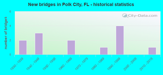
- New bridges - historical statistics
- 21930-1939
- 31940-1949
- 21960-1969
- 11980-1989
- 41990-1999
- 12010-2019


- Bridge Condition - Deck
- 28.6%Very good
- 42.9%Good
- 28.6%Satisfactory

- Bridge Condition - Superstructure
- 14.3%Very good
- 71.4%Good
- 14.3%Satisfactory

- Bridge Condition - Substructure
- 14.3%Very good
- 85.7%Good

- Bridge Condition - Channel
- 28.6%Excellent
- 28.6%Very good
- 42.9%Good

- Bridge Condition - Culverts
- 66.7%Good
- 33.3%Satisfactory
Find on map >> Show street view
Structure Number: 160004, Location: 7.2 MI NORTH OF I-4 (Lat: 28.199778, Lng: -81.820417), Route carried "on" structure: State highway 33, Year Built: 1939, Year Reconstructed: 1976, Status: Open, Structure Length: 0.77m (2.53ft), Average Daily Traffic: 7,568 (year 2020), Truck Traffic: 24%, Average Future Daily Traffic: 13,130 (year 2042), Design Load: H 15, Features Intersected: KELLY L SLOUGH
Minimum Vertical Clearance: 30+ m (98+ ft), Kilometerpoint: 25.259, Lanes on structure: 2, Base Highway Network: Yes, Owner: State Highway Agency, Approaching Roadway Width: 10.4m (34.1ft), Material/Design: Concrete, Design/Construction: Culvert, Number Of Spans In Main Unit: 3, Length of Maximum Span: 2.4m (7.9ft)
Condition: Channel: Good, Culverts: Good, Operating Rating: 52.6 metric tons, Method Used To Determine Operating Rating: Allowable Stress (AS), Inventory Rating: 31.8 metric tons, Method Used To Determine Inventory Rating: Allowable Stress (AS), Structural Evaluation: Better than present minimum criteria, Waterway Adequacy: Equal to present desirable criteria, Approach Roadway Alignment: Equal to present desirable criteria, Designated Inspection Frequency: Every 24 months, Inspection Date: May 2021
Find on map >> Show street view
Structure Number: 160005, Location: 9.8 MI NORTH OF I-4 (Lat: 28.239069, Lng: -81.820894), Route carried "on" structure: State highway 33, Year Built: 1939, Year Reconstructed: 1976, Status: Open, Structure Length: 0.77m (2.53ft), Average Daily Traffic: 7,568 (year 2020), Truck Traffic: 24%, Average Future Daily Traffic: 13,130 (year 2042), Design Load: H 15, Features Intersected: DIERS CANAL
Minimum Vertical Clearance: 30+ m (98+ ft), Kilometerpoint: 29.602, Lanes on structure: 2, Base Highway Network: Yes, Owner: State Highway Agency, Approaching Roadway Width: 10.6m (34.8ft), Material/Design: Concrete, Design/Construction: Culvert, Number Of Spans In Main Unit: 3, Length of Maximum Span: 2.4m (7.9ft)
Condition: Channel: Good, Culverts: Satisfactory, Operating Rating: 52.6 metric tons, Method Used To Determine Operating Rating: Allowable Stress (AS), Inventory Rating: 31.8 metric tons, Method Used To Determine Inventory Rating: Allowable Stress (AS), Structural Evaluation: Equal to present minimum criteria, Waterway Adequacy: Equal to present desirable criteria, Approach Roadway Alignment: Equal to present desirable criteria, Designated Inspection Frequency: Every 24 months, Inspection Date: May 2021
Find on map >> Show street view
Structure Number: 160123, Location: 5.7MI N OF I-4 (SR-400) (Lat: 28.179269, Lng: -81.827428), Route carried "on" structure: State highway 33, Year Built: 1949, Status: Open, Structure Length: 9.81m (32.19ft), Average Daily Traffic: 11,000 (year 2020), Truck Traffic: 4%, Average Future Daily Traffic: 19,085 (year 2042), Design Load: H 20, Features Intersected: CR-655
Minimum Vertical Clearance: 30+ m (98+ ft), Kilometerpoint: 22.700, Lanes on structure: 2, Lanes under structure: 2, Owner: State Highway Agency, Approaching Roadway Width: 8.5m (27.9ft), Material/Design: Steel, Design/Construction: Stringer/Multi-beam, Number Of Spans In Main Unit: 8, Length of Maximum Span: 17.1m (56.1ft), Curb or Sidewalk Widths: Left: 0.9m (3.0ft), Right: 0.9m (3.0ft), Curb-To-Curb Width: 8.5m (27.9ft), Out-to-Out Width: 11.1m (36.4ft)
Condition: Deck: Satisfactory, Superstructure: Good, Substructure: Good, Operating Rating: 48.1 metric tons, Method Used To Determine Operating Rating: Load Factor (LF), Inventory Rating: 29.0 metric tons, Method Used To Determine Inventory Rating: Load Factor (LF), Structural Evaluation: Better than present minimum criteria, Deck Geometry: Meets minimum limits, Underclear: High priority of corrective action, Approach Roadway Alignment: Better than present minimum criteria, Length Of Structure Improvement: 9.81m (32.19ft), Designated Inspection Frequency: Every 24 months, Inspection Date: May 2021, Bridge Improvement Cost: $175,000, Roadway Improvement Cost: $18,000, Total Project Cost: $198,000, Deck Structure Type: Concrete Cast-file-Place
Find on map >> Show street view
Structure Number: 160145, Location: 8.4 MI NORTH OF I-4 (Lat: 28.216794, Lng: -81.820500), Route carried "on" structure: State highway 33, Year Built: 1940, Year Reconstructed: 1976, Status: Open, Structure Length: 0.63m (2.07ft), Average Daily Traffic: 7,568 (year 2020), Truck Traffic: 24%, Average Future Daily Traffic: 13,130 (year 2042), Design Load: H 15, Features Intersected: LIZARD CREEK
Minimum Vertical Clearance: 30+ m (98+ ft), Kilometerpoint: 27.134, Lanes on structure: 2, Base Highway Network: Yes, Owner: State Highway Agency, Approaching Roadway Width: 10.6m (34.8ft), Material/Design: Concrete, Design/Construction: Culvert, Number Of Spans In Main Unit: 2, Length of Maximum Span: 3.0m (9.8ft)
Condition: Channel: Good, Culverts: Good, Operating Rating: 68.9 metric tons, Method Used To Determine Operating Rating: Load Factor (LF), Inventory Rating: 41.7 metric tons, Method Used To Determine Inventory Rating: Load Factor (LF), Structural Evaluation: Better than present minimum criteria, Waterway Adequacy: Equal to present desirable criteria, Approach Roadway Alignment: Equal to present desirable criteria, Designated Inspection Frequency: Every 24 months, Inspection Date: May 2021
Find on map >> Show street view
Structure Number: 160208, Location: 1.2 MI NORTH OF US-98 (Lat: 27.919872, Lng: -81.823864), Route carried "on" structure: US 17, Year Built: 1985, Status: Open, Structure Length: 12.27m (40.26ft), Average Daily Traffic: 25,000 (year 2020), Truck Traffic: 13%, Average Future Daily Traffic: 43,375 (year 2042), Design Load: HS 20+Mod, Features Intersected: SADDLE CREEK
Minimum Vertical Clearance: 30+ m (98+ ft), Kilometerpoint: 31.466, Lanes on structure: 4, Base Highway Network: Yes, Owner: State Highway Agency, Approaching Roadway Width: 26.9m (88.3ft), Skew: 21 degrees, Material/Design: Prestressed concrete, Design/Construction: Stringer/Multi-beam, Number Of Spans In Main Unit: 6, Length of Maximum Span: 20.4m (66.9ft), Curb-To-Curb Width: 26.9m (88.3ft), Out-to-Out Width: 27.8m (91.2ft)
Condition: Deck: Satisfactory, Superstructure: Good, Substructure: Good, Channel: Excellent, Operating Rating: 47.2 metric tons, Method Used To Determine Operating Rating: Allowable Stress (AS), Inventory Rating: 40.8 metric tons, Method Used To Determine Inventory Rating: Allowable Stress (AS), Structural Evaluation: Better than present minimum criteria, Deck Geometry: Superior to present desirable criteria, Waterway Adequacy: Equal to present desirable criteria, Approach Roadway Alignment: Equal to present desirable criteria, Designated Inspection Frequency: Every 24 months, Inspection Date: October 2020, Deck Structure Type: Concrete Cast-file-Place
Find on map >> Show street view
Structure Number: 160281, Location: I-4/SR 400 (Lat: 28.154414, Lng: -81.846725), Route carried "on" structure: State highway 570, Year Built: 1999, Status: Open, Structure Length: 9.79m (32.12ft), Average Daily Traffic: 4,550 (year 2020), Truck Traffic: 17%, Average Future Daily Traffic: 7,894 (year 2042), Design Load: HS 20+Mod, Features Intersected: I-4/SR400
Minimum Vertical Clearance: 30+ m (98+ ft), Kilometerpoint: 39.138, Lanes on structure: 1, Lanes under structure: 6, Base Highway Network: Yes, Toll: On toll road, Owner: State Toll Authority, Approaching Roadway Width: 7.9m (25.9ft), Material/Design: Prestressed concrete, Design/Construction: Stringer/Multi-beam, Number Of Spans In Main Unit: 3, Length of Maximum Span: 42.1m (138.1ft), Curb-To-Curb Width: 8.3m (27.2ft), Out-to-Out Width: 9.2m (30.2ft)
Condition: Deck: Good, Superstructure: Good, Substructure: Good, Operating Rating: 75.9 metric tons, Method Used To Determine Operating Rating: Load Factor (LF), Inventory Rating: 45.5 metric tons, Method Used To Determine Inventory Rating: Load Factor (LF), Structural Evaluation: Better than present minimum criteria, Deck Geometry: High priority of corrective action, Underclear: High priority of corrective action, Approach Roadway Alignment: Equal to present minimum criteria, Designated Inspection Frequency: Every 24 months, Inspection Date: April 2020, Deck Structure Type: Concrete Cast-file-Place
Find on map >> Show street view
Structure Number: 160282, Location: I-4 EAST INTERCHANGE (Lat: 28.154439, Lng: -81.846464), Route carried "on" structure: State highway 570, Year Built: 1999, Status: Open, Structure Length: 9.80m (32.15ft), Average Daily Traffic: 4,550 (year 2020), Truck Traffic: 17%, Average Future Daily Traffic: 7,894 (year 2042), Design Load: HS 20, Features Intersected: I-4 SR 400
Minimum Vertical Clearance: 30+ m (98+ ft), Kilometerpoint: 39.138, Lanes on structure: 1, Lanes under structure: 6, Base Highway Network: Yes, Toll: On toll road, Owner: State Toll Authority, Approaching Roadway Width: 11.0m (36.1ft), Material/Design: Prestressed concrete, Design/Construction: Stringer/Multi-beam, Number Of Spans In Main Unit: 3, Length of Maximum Span: 42.1m (138.1ft), Curb-To-Curb Width: 12.2m (40.0ft), Out-to-Out Width: 13.1m (43.0ft)
Condition: Deck: Very good, Superstructure: Good, Substructure: Good, Operating Rating: 75.4 metric tons, Method Used To Determine Operating Rating: Load Factor (LF), Inventory Rating: 45.3 metric tons, Method Used To Determine Inventory Rating: Load Factor (LF), Structural Evaluation: Better than present minimum criteria, Deck Geometry: Equal to present minimum criteria, Underclear: High priority of corrective action, Approach Roadway Alignment: Equal to present minimum criteria, Designated Inspection Frequency: Every 24 months, Inspection Date: April 2020, Deck Structure Type: Concrete Cast-file-Place
Find on map >> Show street view
Structure Number: 164149, Location: 1.0 MI WEST OF SR-33 (Lat: 28.258542, Lng: -81.842600), Route carried "on" structure: County highway , Year Built: 1960, Status: Open, Structure Length: 1.83m (6.00ft), Average Daily Traffic: 1,809 (year 2021), Truck Traffic: 17%, Average Future Daily Traffic: 3,139 (year 2042), Design Load: HS 20, Features Intersected: PONY CREEK, Facility Carried by Structure: DEAN STILL RD.
Minimum Vertical Clearance: 30+ m (98+ ft), Kilometerpoint: 0.000, Lanes on structure: 2, Owner: County Highway Agency, Approaching Roadway Width: 8.6m (28.2ft), Material/Design: Prestressed concrete, Design/Construction: Channel Beam, Number Of Spans In Main Unit: 3, Length of Maximum Span: 6.1m (20.0ft), Curb-To-Curb Width: 8.6m (28.2ft), Out-to-Out Width: 9.4m (30.8ft)
Condition: Deck: Good, Superstructure: Satisfactory, Substructure: Good, Channel: Very good, Operating Rating: 37.9 metric tons, Method Used To Determine Operating Rating: Load Factor (LF), Inventory Rating: 22.5 metric tons, Method Used To Determine Inventory Rating: Load Factor (LF), Structural Evaluation: Equal to present minimum criteria, Deck Geometry: Somewhat better than minimum adequacy, Waterway Adequacy: Better than present minimum criteria, Approach Roadway Alignment: Equal to present desirable criteria, Designated Inspection Frequency: Every 24 months, Inspection Date: May 2021, Deck Structure Type: Other, Wearing Surface/Protective System: Wearing Surface: Epoxy Overlay
Find on map >> Show street view
Structure Number: 16415, Location: 0.6 MI EAST OF SR-33 (Lat: 28.258547, Lng: -81.815281), Route carried "on" structure: County highway , Year Built: 1960, Status: Open, Structure Length: 1.83m (6.00ft), Average Daily Traffic: 2,071 (year 2021), Truck Traffic: 27%, Average Future Daily Traffic: 3,593 (year 2042), Design Load: HS 20, Features Intersected: KIM'S CREEK, Facility Carried by Structure: DEAN STILL RD.
Minimum Vertical Clearance: 30+ m (98+ ft), Kilometerpoint: 0.914, Lanes on structure: 2, Owner: County Highway Agency, Approaching Roadway Width: 7.6m (24.9ft), Material/Design: Prestressed concrete, Design/Construction: Channel Beam, Number Of Spans In Main Unit: 3, Length of Maximum Span: 6.1m (20.0ft), Curb-To-Curb Width: 8.7m (28.5ft), Out-to-Out Width: 9.6m (31.5ft)
Condition: Deck: Good, Superstructure: Good, Substructure: Good, Channel: Very good, Operating Rating: 49.4 metric tons, Method Used To Determine Operating Rating: Load Factor (LF), Inventory Rating: 29.8 metric tons, Method Used To Determine Inventory Rating: Load Factor (LF), Structural Evaluation: Better than present minimum criteria, Deck Geometry: Meets minimum limits, Waterway Adequacy: Equal to present desirable criteria, Approach Roadway Alignment: Equal to present desirable criteria, Designated Inspection Frequency: Every 24 months, Inspection Date: May 2021, Deck Structure Type: Other, Wearing Surface/Protective System: Wearing Surface: Bituminous
Find on map >> Show street view
Structure Number: 164548, Location: 2.5 MI NORTH OF SR 60 (Lat: 27.923581, Lng: -81.683792), Route carried "on" structure: County highway , Year Built: 2014, Status: Open, Structure Length: 1.10m (3.61ft), Average Daily Traffic: 1,100 (year 2020), Truck Traffic: 4%, Average Future Daily Traffic: 1,909 (year 2042), Design Load: HL 93, Features Intersected: PARTS DITCH, Facility Carried by Structure: OLD BARTOW LK WALE
Minimum Vertical Clearance: 30.18m (99.02ft), Kilometerpoint: 0.000, Lanes on structure: 2, Owner: County Highway Agency, Approaching Roadway Width: 11.0m (36.1ft), Material/Design: Concrete, Design/Construction: Slab, Number Of Spans In Main Unit: 1, Length of Maximum Span: 11.0m (36.1ft), Curb-To-Curb Width: 11.0m (36.1ft), Out-to-Out Width: 11.9m (39.0ft)
Condition: Deck: Very good, Superstructure: Very good, Substructure: Very good, Channel: Excellent, Operating Rating: 60.8 metric tons, Method Used To Determine Operating Rating: Load and Resistance Factor (LRFR), Inventory Rating: 46.7 metric tons, Method Used To Determine Inventory Rating: Load and Resistance Factor (LRFR), Structural Evaluation: Equal to present desirable criteria, Deck Geometry: Equal to present minimum criteria, Waterway Adequacy: Superior to present desirable criteria, Approach Roadway Alignment: Equal to present desirable criteria, Designated Inspection Frequency: Every 24 months, Inspection Date: October 2020, Deck Structure Type: Concrete Cast-file-Place
Find on map >> Show street view
Structure Number: 160123, Location: 5.7MI N OF I-4 (SR-400) (Lat: 28.179269, Lng: -81.827428), Route carried "under" structure: County highway 655, Year Built: 1949, Structure Length: 0. m, Average Daily Traffic: 10,000 (year 2020), Truck Traffic: 12%, Features Intersected: CR-655, Facility Carried by Structure: SR-33
Minimum Vertical Clearance: 7.74m (25.39ft), Kilometerpoint: 47.247, Lanes on structure: 2, Lanes under structure: 2, Material/Design: Steel, Design/Construction: Stringer/Multi-beam, Length of Maximum Span: 17.1m (56.1ft)
Find on map >> Show street view
Structure Number: 160281, Location: I-4/SR 400 (Lat: 28.154414, Lng: -81.846725), Route carried "under" structure: Interstate 4, Year Built: 1999, Structure Length: 0. m, Average Daily Traffic: 96,000 (year 2020), Truck Traffic: 19%, Features Intersected: I-4/SR400
Minimum Vertical Clearance: 5.76m (18.90ft), Kilometerpoint: 25.207, Lanes on structure: 1, Lanes under structure: 6, Material/Design: Prestressed concrete, Design/Construction: Stringer/Multi-beam, Length of Maximum Span: 42.1m (138.1ft)
Find on map >> Show street view
Structure Number: 160282, Location: I-4 EAST INTERCHANGE (Lat: 28.154439, Lng: -81.846464), Route carried "under" structure: Interstate 4, Year Built: 1999, Structure Length: 0. m, Average Daily Traffic: 85,157 (year 2020), Truck Traffic: 14%, Features Intersected: I-4 SR 400
Minimum Vertical Clearance: 5.46m (17.91ft), Kilometerpoint: 25.231, Lanes on structure: 1, Lanes under structure: 6, Material/Design: Prestressed concrete, Design/Construction: Stringer/Multi-beam, Length of Maximum Span: 42.1m (138.1ft)