Bridge Statistics for Pocono Springs, Pennsylvania (PA)
Condition, Traffic, Stress, Structural Evaluation, Project Costs
- National Bridge Inventory (NBI) Statistics
- 17Number of bridges
- 98ft / 30.0mTotal length
- $4,206,000Total costs
- 41,505Total average daily traffic
- 11,220Total average daily truck traffic
- National Bridge Inventory (NBI) Registered Bridges for Pocono Springs
- No street view available for this location
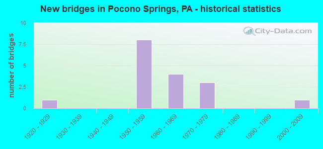
- New bridges - historical statistics
- 11920-1929
- 81950-1959
- 41960-1969
- 31970-1979
- 12000-2009

- Reconstructed bridges - Historical Statistics
- 11980-1989
- 01990-1999
- 12000-2009


- Bridge Condition - Deck
- 9.1%Good
- 45.5%Satisfactory
- 18.2%Fair
- 9.1%Poor
- 9.1%Serious
- 9.1%Critical

- Bridge Condition - Superstructure
- 8.3%Very good
- 41.7%Satisfactory
- 25.0%Fair
- 16.7%Serious
- 8.3%Critical

- Bridge Condition - Substructure
- 8.3%Very good
- 8.3%Good
- 41.7%Satisfactory
- 16.7%Fair
- 25.0%Poor

- Bridge Condition - Channel
- 10.0%Very good
- 40.0%Good
- 10.0%Fair
- 40.0%Poor
Find on map >> Show street view
Structure Number: 29876, Location: GREENE TWP 100' S SR 3008 (Lat: 41.253297, Lng: -75.342186), Route carried "on" structure: State highway 191, Year Built: 1957, Status: Open, Structure Length: 0.88m (2.89ft), Average Daily Traffic: 528 (year 2022), Truck Traffic: 14%, Average Future Daily Traffic: 831 (year 2032), Design Load: HS 20, Features Intersected: TRIBUTARY TO TAYLOR CRK
Minimum Vertical Clearance: 30+ m (98+ ft), Kilometerpoint: 0.813, Lanes on structure: 2, Base Highway Network: Yes, Owner: State Highway Agency, Approaching Roadway Width: 6.7m (22.0ft), Skew: 1 degrees, Material/Design: Concrete, Design/Construction: Tee Beam, Number Of Spans In Main Unit: 1, Length of Maximum Span: 8.5m (27.9ft), Curb or Sidewalk Widths: Left: 0.5m (1.6ft), Right: 0.5m (1.6ft), Curb-To-Curb Width: 9.4m (30.8ft), Out-to-Out Width: 10.5m (34.4ft)
Condition: Deck: Fair, Superstructure: Fair, Substructure: Satisfactory, Channel: Good, Operating Rating: 75.3 metric tons, Method Used To Determine Operating Rating: Load Factor (LF), Inventory Rating: 45.4 metric tons, Method Used To Determine Inventory Rating: Load Factor (LF), Structural Evaluation: Somewhat better than minimum adequacy, Deck Geometry: Equal to present minimum criteria, Waterway Adequacy: Superior to present desirable criteria, Approach Roadway Alignment: Equal to present desirable criteria, Length Of Structure Improvement: 0.90m (2.95ft), Designated Inspection Frequency: Every 24 months, Inspection Date: May 2021, Bridge Improvement Cost: $14,000, Roadway Improvement Cost: $100,000, Total Project Cost: $187,000, Deck Structure Type: Concrete Cast-file-Place, Wearing Surface/Protective System: Wearing Surface: Monolithic Concrete
Find on map >> Show street view
Structure Number: 29999, Location: GREENE TWP 100' E TR 191 (Lat: 41.267828, Lng: -75.338275), Route carried "on" structure: State highway , Year Built: 1955, Status: Posted for load, Structure Length: 2.04m (6.69ft), Average Daily Traffic: 246 (year 2021), Truck Traffic: 7%, Average Future Daily Traffic: 212 (year 2032), Design Load: HS 20, Features Intersected: WALLENPAUPACK CREEK, Facility Carried by Structure: SR 3012
Minimum Vertical Clearance: 30+ m (98+ ft), Kilometerpoint: 0.000, Lanes on structure: 2, Owner: State Highway Agency, Approaching Roadway Width: 7.0m (23.0ft), Skew: 1 degrees, Material/Design: Prestressed concrete, Design/Construction: Box Beam or Girders - Multiple, Number Of Spans In Main Unit: 1, Length of Maximum Span: 20.1m (65.9ft), Curb or Sidewalk Widths: Left: 0.3m (1.0ft), Right: 0.3m (1.0ft), Curb-To-Curb Width: 9.5m (31.2ft), Out-to-Out Width: 10.3m (33.8ft)
Condition: Deck: Critical, Superstructure: Critical, Substructure: Poor, Channel: Poor, Operating Rating: 29.9 metric tons, Method Used To Determine Operating Rating: Load Factor (LF), Inventory Rating: 12.7 metric tons, Method Used To Determine Inventory Rating: Load Factor (LF), Structural Evaluation: High priority of replacement, Deck Geometry: Equal to present minimum criteria, Waterway Adequacy: Equal to present desirable criteria, Approach Roadway Alignment: Equal to present desirable criteria, Bridge Posting: Required (Relationship of Operating Rating to Maximum Legal Load: 20.0 - 29.9% below), Length Of Structure Improvement: 2.00m (6.56ft), Designated Inspection Frequency: Every 24 months, Other Special Inspection Frequency: Every 6 months, Inspection Date: May 2021, Other Special Inspection Date: May 2021, Bridge Improvement Cost: $15,000, Roadway Improvement Cost: $99,000, Total Project Cost: $198,000, Deck Structure Type: Other, Wearing Surface/Protective System: Wearing Surface: Bituminous
Find on map >> Show street view
Structure Number: 3003, Location: LA ANNA (Lat: 41.247950, Lng: -75.332783), Route carried "on" structure: City street , Year Built: 1956, Status: Posted for load, Structure Length: 1.31m (4.30ft), Average Daily Traffic: 50 (year 2013), Average Future Daily Traffic: 70 (year 2023), Design Load: HS 20, Features Intersected: TAYLOR CREEK, Facility Carried by Structure: CARLTON ROAD
Minimum Vertical Clearance: 30+ m (98+ ft), Kilometerpoint: 0.000, Lanes on structure: 2, Owner: County Highway Agency, Approaching Roadway Width: 5.5m (18.0ft), Skew: 1 degrees, Material/Design: Prestressed concrete, Design/Construction: Box Beam or Girders - Multiple, Number Of Spans In Main Unit: 1, Length of Maximum Span: 12.8m (42.0ft), Curb or Sidewalk Widths: Left: 0.1m (0.3ft), Right: 0.1m (0.3ft), Curb-To-Curb Width: 5.5m (18.0ft), Out-to-Out Width: 7.4m (24.3ft)
Condition: Deck: Serious, Superstructure: Serious, Substructure: Satisfactory, Channel: Good, Operating Rating: 23.6 metric tons, Method Used To Determine Operating Rating: Load Factor (LF), Inventory Rating: 10.9 metric tons, Method Used To Determine Inventory Rating: Load Factor (LF), Structural Evaluation: High priority of corrective action, Deck Geometry: Meets minimum limits, Waterway Adequacy: Better than present minimum criteria, Approach Roadway Alignment: Equal to present desirable criteria, Bridge Posting: Required (Relationship of Operating Rating to Maximum Legal Load: > 39.9% below), Length Of Structure Improvement: 2.00m (6.56ft), Designated Inspection Frequency: Every 24 months, Other Special Inspection Frequency: Every 6 months, Inspection Date: September 2019, Other Special Inspection Date: March 2021, Bridge Improvement Cost: $40,000, Roadway Improvement Cost: $117,000, Total Project Cost: $537,000, Deck Structure Type: Other, Wearing Surface/Protective System: Wearing Surface: Bituminous
Find on map >> Show street view
Structure Number: 35438, Location: STERLING TWP OVER TR 196 (Lat: 41.351258, Lng: -75.387392), Route carried "on" structure: Interstate 84, Year Built: 1969, Year Reconstructed: 2012, Status: Open, Structure Length: 3.66m (12.01ft), Average Daily Traffic: 7,691 (year 2021), Truck Traffic: 35%, Average Future Daily Traffic: 12,742 (year 2032), Design Load: HS 20+Mod, Features Intersected: SR 0196 TR 196
Minimum Vertical Clearance: 30+ m (98+ ft), Kilometerpoint: 5.309, Lanes on structure: 2, Lanes under structure: 2, Base Highway Network: Yes, Owner: State Highway Agency, Approaching Roadway Width: 12.8m (42.0ft), Skew: 3 degrees, Material/Design: Prestressed concrete, Design/Construction: Box Beam or Girders - Single/Spread, Number Of Spans In Main Unit: 3, Length of Maximum Span: 13.7m (44.9ft), Curb or Sidewalk Widths: Left: 0.2m (0.7ft), Right: 0.2m (0.7ft), Curb-To-Curb Width: 12.4m (40.7ft), Out-to-Out Width: 13.4m (44.0ft)
Condition: Deck: Good, Superstructure: Fair, Substructure: Fair, Operating Rating: 45.4 metric tons, Method Used To Determine Operating Rating: Load Factor (LF), Inventory Rating: 27.2 metric tons, Method Used To Determine Inventory Rating: Load Factor (LF), Structural Evaluation: Somewhat better than minimum adequacy, Deck Geometry: Better than present minimum criteria, Underclear: Meets minimum limits, Approach Roadway Alignment: Equal to present desirable criteria, Length Of Structure Improvement: 3.70m (12.14ft), Designated Inspection Frequency: Every 24 months, Inspection Date: Febuary 2021, Bridge Improvement Cost: $53,000, Roadway Improvement Cost: $156,000, Total Project Cost: $716,000, Deck Structure Type: Concrete Cast-file-Place, Wearing Surface/Protective System: Wearing Surface: Monolithic Concrete, Deck Protection: Epoxy Coated Reinforcing
Find on map >> Show street view
Structure Number: 35458, Location: STERLING TP .3M S SR 3003 (Lat: 41.344631, Lng: -75.362914), Route carried "on" structure: State highway 191, Year Built: 1957, Status: Posted for load, Structure Length: 0.82m (2.69ft), Average Daily Traffic: 1,789 (year 2022), Truck Traffic: 15%, Average Future Daily Traffic: 2,616 (year 2032), Design Load: HS 20, Features Intersected: BUTTERNUT CREEK
Minimum Vertical Clearance: 30+ m (98+ ft), Kilometerpoint: 12.822, Lanes on structure: 2, Base Highway Network: Yes, Owner: State Highway Agency, Approaching Roadway Width: 7.6m (24.9ft), Material/Design: Prestressed concrete, Design/Construction: Box Beam or Girders - Multiple, Number Of Spans In Main Unit: 1, Length of Maximum Span: 7.9m (25.9ft), Curb-To-Curb Width: 9.4m (30.8ft), Out-to-Out Width: 10.2m (33.5ft)
Condition: Deck: Poor, Superstructure: Serious, Substructure: Poor, Channel: Poor, Operating Rating: 39.0 metric tons, Method Used To Determine Operating Rating: Load Factor (LF), Inventory Rating: 21.8 metric tons, Method Used To Determine Inventory Rating: Load Factor (LF), Structural Evaluation: High priority of corrective action, Deck Geometry: Somewhat better than minimum adequacy, Waterway Adequacy: Superior to present desirable criteria, Approach Roadway Alignment: Equal to present desirable criteria, Bridge Posting: Required (Relationship of Operating Rating to Maximum Legal Load: 20.0 - 29.9% below), Length Of Structure Improvement: 0.80m (2.62ft), Designated Inspection Frequency: Every 24 months, Other Special Inspection Frequency: Every 6 months, Inspection Date: April 2021, Other Special Inspection Date: April 2021, Bridge Improvement Cost: $12,000, Roadway Improvement Cost: $100,000, Total Project Cost: $163,000, Deck Structure Type: Other, Wearing Surface/Protective System: Wearing Surface: Bituminous
Find on map >> Show street view
Structure Number: 35491, Location: STERLING TWP 1M S SR 3002 (Lat: 41.326261, Lng: -75.392175), Route carried "on" structure: State highway 196, Year Built: 1954, Status: Open, Structure Length: 1.04m (3.41ft), Average Daily Traffic: 1,272 (year 2020), Truck Traffic: 5%, Average Future Daily Traffic: 1,949 (year 2032), Design Load: H 20, Features Intersected: BUTTERNUT CREEK
Minimum Vertical Clearance: 30+ m (98+ ft), Kilometerpoint: 10.430, Lanes on structure: 2, Owner: State Highway Agency, Approaching Roadway Width: 7.0m (23.0ft), Material/Design: Concrete, Design/Construction: Tee Beam, Number Of Spans In Main Unit: 1, Length of Maximum Span: 9.8m (32.2ft), Curb or Sidewalk Widths: Left: 0.2m (0.7ft), Right: 0.2m (0.7ft), Curb-To-Curb Width: 7.3m (24.0ft), Out-to-Out Width: 8.4m (27.6ft)
Condition: Deck: Satisfactory, Superstructure: Fair, Substructure: Satisfactory, Channel: Fair, Operating Rating: 53.5 metric tons, Method Used To Determine Operating Rating: Load Factor (LF), Inventory Rating: 31.8 metric tons, Method Used To Determine Inventory Rating: Load Factor (LF), Structural Evaluation: Somewhat better than minimum adequacy, Deck Geometry: Meets minimum limits, Waterway Adequacy: Better than present minimum criteria, Approach Roadway Alignment: Better than present minimum criteria, Length Of Structure Improvement: 1.00m (3.28ft), Designated Inspection Frequency: Every 24 months, Inspection Date: April 2021, Bridge Improvement Cost: $12,000, Roadway Improvement Cost: $100,000, Total Project Cost: $161,000, Deck Structure Type: Concrete Cast-file-Place, Wearing Surface/Protective System: Wearing Surface: Bituminous
Find on map >> Show street view
Structure Number: 35492, Location: STERLING TWP OVER I-84 EB (Lat: 41.350256, Lng: -75.387333), Route carried "on" structure: State highway 196, Year Built: 1969, Year Reconstructed: 1980, Status: Open, Structure Length: 3.54m (11.61ft), Average Daily Traffic: 1,454 (year 2020), Truck Traffic: 6%, Average Future Daily Traffic: 1,857 (year 2032), Design Load: HS 20+Mod, Features Intersected: SR 0084 I-84 EB
Minimum Vertical Clearance: 30+ m (98+ ft), Kilometerpoint: 12.712, Lanes on structure: 2, Lanes under structure: 2, Owner: State Highway Agency, Approaching Roadway Width: 7.9m (25.9ft), Skew: 4 degrees, Material/Design: Prestressed concrete, Design/Construction: Stringer/Multi-beam, Number Of Spans In Main Unit: 1, Length of Maximum Span: 34.4m (112.9ft), Curb or Sidewalk Widths: Left: 0.2m (0.7ft), Right: 0.2m (0.7ft), Curb-To-Curb Width: 9.8m (32.2ft), Out-to-Out Width: 11.0m (36.1ft)
Condition: Deck: Satisfactory, Superstructure: Satisfactory, Substructure: Satisfactory, Operating Rating: 87.1 metric tons, Method Used To Determine Operating Rating: Load Factor (LF), Inventory Rating: 19.1 metric tons, Method Used To Determine Inventory Rating: Load Factor (LF), Structural Evaluation: Somewhat better than minimum adequacy, Deck Geometry: Somewhat better than minimum adequacy, Underclear: Somewhat better than minimum adequacy, Approach Roadway Alignment: Equal to present desirable criteria, Length Of Structure Improvement: 3.50m (11.48ft), Designated Inspection Frequency: Every 24 months, Inspection Date: April 2021, Bridge Improvement Cost: $26,000, Roadway Improvement Cost: $100,000, Total Project Cost: $351,000, Deck Structure Type: Concrete Cast-file-Place, Wearing Surface/Protective System: Wearing Surface: Latex Concrete
Find on map >> Show street view
Structure Number: 35542, Location: DREHER TWP .7 M E TR 196 (Lat: 41.284031, Lng: -75.359500), Route carried "on" structure: State highway 507, Year Built: 1959, Status: Open, Structure Length: 0.94m (3.08ft), Average Daily Traffic: 1,002 (year 2022), Truck Traffic: 14%, Average Future Daily Traffic: 1,510 (year 2032), Design Load: HS 20, Features Intersected: MILL CREEK
Minimum Vertical Clearance: 30+ m (98+ ft), Kilometerpoint: 13.927, Lanes on structure: 2, Owner: State Highway Agency, Approaching Roadway Width: 7.9m (25.9ft), Skew: 5 degrees, Material/Design: Concrete, Design/Construction: Culvert, Number Of Spans In Main Unit: 1, Length of Maximum Span: 9.4m (30.8ft)
Condition: Channel: Poor, Culverts: Poor, Operating Rating: 49.0 metric tons, Method Used To Determine Operating Rating: Field evaluation and documented engineering judgment, Inventory Rating: 32.7 metric tons, Method Used To Determine Inventory Rating: Field evaluation and documented engineering judgment, Structural Evaluation: Meets minimum limits, Waterway Adequacy: Equal to present desirable criteria, Approach Roadway Alignment: Equal to present desirable criteria, Length Of Structure Improvement: 0.90m (2.95ft), Designated Inspection Frequency: Every 24 months, Other Special Inspection Frequency: Every 6 months, Inspection Date: April 2021, Other Special Inspection Date: October 2021, Bridge Improvement Cost: $22,000, Roadway Improvement Cost: $100,000, Total Project Cost: $296,000
Find on map >> Show street view
Structure Number: 3566, Location: STERLING TWP 1M E LACK CY (Lat: 41.347756, Lng: -75.428431), Route carried "on" structure: State highway , Year Built: 1929, Status: Open, Structure Length: 0.64m (2.10ft), Average Daily Traffic: 584 (year 2021), Truck Traffic: 5%, Average Future Daily Traffic: 635 (year 2032), Features Intersected: STEVENS CREEK, Facility Carried by Structure: SR 3002 SPRG HL RD
Minimum Vertical Clearance: 30+ m (98+ ft), Kilometerpoint: 1.542, Lanes on structure: 2, Owner: State Highway Agency, Approaching Roadway Width: 6.1m (20.0ft), Skew: 3 degrees, Material/Design: Concrete, Design/Construction: Slab, Number Of Spans In Main Unit: 1, Length of Maximum Span: 6.1m (20.0ft), Curb or Sidewalk Widths: Left: 0.2m (0.7ft), Right: 0.2m (0.7ft), Curb-To-Curb Width: 5.2m (17.1ft), Out-to-Out Width: 6.2m (20.3ft)
Condition: Deck: Satisfactory, Superstructure: Satisfactory, Substructure: Poor, Channel: Poor, Operating Rating: 44.5 metric tons, Method Used To Determine Operating Rating: Load Factor (LF), Inventory Rating: 27.2 metric tons, Method Used To Determine Inventory Rating: Load Factor (LF), Structural Evaluation: Meets minimum limits, Deck Geometry: High priority of replacement, Waterway Adequacy: Better than present minimum criteria, Approach Roadway Alignment: Equal to present desirable criteria, Length Of Structure Improvement: 0.60m (1.97ft), Designated Inspection Frequency: Every 24 months, Inspection Date: April 2021, Bridge Improvement Cost: $24,000, Roadway Improvement Cost: $157,000, Total Project Cost: $326,000, Wearing Surface/Protective System: Wearing Surface: Bituminous
Find on map >> Show street view
Structure Number: 35663, Location: STERLING TWP 1 M E TR 196 (Lat: 41.331950, Lng: -75.375850), Route carried "on" structure: State highway , Year Built: 1958, Status: Open, Structure Length: 1.04m (3.41ft), Average Daily Traffic: 54 (year 2018), Truck Traffic: 10%, Average Future Daily Traffic: 89 (year 2032), Design Load: HS 20, Features Intersected: BUTTERNUT CREEK, Facility Carried by Structure: TWP RD 343 BTRNT R
Minimum Vertical Clearance: 30+ m (98+ ft), Kilometerpoint: 5.506, Lanes on structure: 2, Owner: State Highway Agency, Approaching Roadway Width: 4.6m (15.1ft), Skew: 1 degrees, Material/Design: Concrete, Design/Construction: Tee Beam, Number Of Spans In Main Unit: 1, Length of Maximum Span: 10.1m (33.1ft), Curb or Sidewalk Widths: Left: 0.2m (0.7ft), Right: 0.2m (0.7ft), Curb-To-Curb Width: 7.9m (25.9ft), Out-to-Out Width: 9.0m (29.5ft)
Condition: Deck: Satisfactory, Superstructure: Satisfactory, Substructure: Satisfactory, Channel: Good, Operating Rating: 54.4 metric tons, Method Used To Determine Operating Rating: Load Factor (LF), Inventory Rating: 32.7 metric tons, Method Used To Determine Inventory Rating: Load Factor (LF), Structural Evaluation: Equal to present minimum criteria, Deck Geometry: Equal to present minimum criteria, Waterway Adequacy: Superior to present desirable criteria, Approach Roadway Alignment: Equal to present desirable criteria, Length Of Structure Improvement: 1.00m (3.28ft), Designated Inspection Frequency: Every 24 months, Inspection Date: April 2021, Bridge Improvement Cost: $13,000, Roadway Improvement Cost: $100,000, Total Project Cost: $179,000, Deck Structure Type: Concrete Cast-file-Place, Wearing Surface/Protective System: Wearing Surface: Bituminous
Find on map >> Show street view
Structure Number: 35676, Location: STERLING TWP OVER I-84 (Lat: 41.356494, Lng: -75.419961), Route carried "on" structure: State highway , Year Built: 1973, Status: Open, Structure Length: 10.79m (35.40ft), Average Daily Traffic: 358 (year 2022), Truck Traffic: 5%, Average Future Daily Traffic: 556 (year 2032), Design Load: HS 20, Features Intersected: SR 0084 I-84 EB & WB, Facility Carried by Structure: SR 3007 NEVILLE RD
Minimum Vertical Clearance: 30+ m (98+ ft), Kilometerpoint: 0.523, Lanes on structure: 2, Lanes under structure: 4, Owner: State Highway Agency, Approaching Roadway Width: 11.6m (38.1ft), Skew: 5 degrees, Material/Design: Steel, Design/Construction: Stringer/Multi-beam, Number Of Spans In Main Unit: 3, Length of Maximum Span: 42.1m (138.1ft), Curb or Sidewalk Widths: Left: 0.2m (0.7ft), Right: 0.2m (0.7ft), Curb-To-Curb Width: 11.6m (38.1ft), Out-to-Out Width: 12.8m (42.0ft)
Condition: Deck: Satisfactory, Superstructure: Satisfactory, Substructure: Fair, Operating Rating: 68.9 metric tons, Method Used To Determine Operating Rating: Load Factor (LF), Inventory Rating: 40.8 metric tons, Method Used To Determine Inventory Rating: Load Factor (LF), Structural Evaluation: Somewhat better than minimum adequacy, Deck Geometry: Superior to present desirable criteria, Underclear: Equal to present minimum criteria, Approach Roadway Alignment: Equal to present desirable criteria, Length Of Structure Improvement: 10.80m (35.43ft), Designated Inspection Frequency: Every 24 months, Inspection Date: April 2021, Bridge Improvement Cost: $59,000, Roadway Improvement Cost: $173,000, Total Project Cost: $793,000, Deck Structure Type: Concrete Cast-file-Place, Wearing Surface/Protective System: Wearing Surface: Latex Concrete
Find on map >> Show street view
Structure Number: 35851, Location: DREHER TWP 300FT E TR 191 (Lat: 41.297344, Lng: -75.327697), Route carried "on" structure: City street , Year Built: 1957, Status: Open, Structure Length: 2.53m (8.30ft), Average Daily Traffic: 135 (year 1998), Truck Traffic: 5%, Average Future Daily Traffic: 100 (year 2035), Design Load: H 20, Features Intersected: WALLENPAUPACK CREEK, Facility Carried by Structure: BR.13 SALATHE T316
Minimum Vertical Clearance: 30+ m (98+ ft), Kilometerpoint: 0.000, Lanes on structure: 2, Owner: County Highway Agency, Approaching Roadway Width: 5.2m (17.1ft), Material/Design: Prestressed concrete, Design/Construction: Box Beam or Girders - Multiple, Number Of Spans In Main Unit: 1, Length of Maximum Span: 24.7m (81.0ft), Curb or Sidewalk Widths: Left: 0.2m (0.7ft), Right: 0.2m (0.7ft), Curb-To-Curb Width: 6.9m (22.6ft), Out-to-Out Width: 7.4m (24.3ft)
Condition: Deck: Fair, Superstructure: Satisfactory, Substructure: Good, Channel: Good, Operating Rating: 58.1 metric tons, Method Used To Determine Operating Rating: Load and Resistance Factor (LRFR), Inventory Rating: 21.8 metric tons, Method Used To Determine Inventory Rating: Load and Resistance Factor (LRFR), Structural Evaluation: Equal to present minimum criteria, Deck Geometry: Meets minimum limits, Waterway Adequacy: Better than present minimum criteria, Approach Roadway Alignment: Equal to present desirable criteria, Length Of Structure Improvement: 2.50m (8.20ft), Designated Inspection Frequency: Every 24 months, Inspection Date: September 2019, Bridge Improvement Cost: $22,000, Roadway Improvement Cost: $109,000, Total Project Cost: $299,000, Deck Structure Type: Other, Wearing Surface/Protective System: Wearing Surface: Bituminous
Find on map >> Show street view
Structure Number: 44287, Location: DRHER TWP .2M S OF TR 507 (Lat: 41.253489, Lng: -75.342611), Route carried "on" structure: State highway 191, Year Built: 2007, Status: Open, Structure Length: 0.73m (2.40ft), Average Daily Traffic: 2,511 (year 2020), Truck Traffic: 8%, Average Future Daily Traffic: 3,807 (year 2032), Design Load: HL 93, Features Intersected: MILL CREEK
Minimum Vertical Clearance: 30.18m (99.02ft), Kilometerpoint: 4.451, Lanes on structure: 2, Base Highway Network: Yes, Owner: State Highway Agency, Approaching Roadway Width: 9.1m (29.9ft), Material/Design: Concrete, Design/Construction: Arch - Deck, Number Of Spans In Main Unit: 1, Length of Maximum Span: 7.3m (24.0ft), Curb or Sidewalk Widths: Left: 0.2m (0.7ft), Right: 0.2m (0.7ft), Curb-To-Curb Width: 11.7m (38.4ft), Out-to-Out Width: 12.8m (42.0ft)
Condition: Superstructure: Very good, Substructure: Very good, Channel: Very good, Operating Rating: 71.7 metric tons, Method Used To Determine Operating Rating: Load Factor (LF), Inventory Rating: 60.8 metric tons, Method Used To Determine Inventory Rating: Load Factor (LF), Structural Evaluation: Equal to present desirable criteria, Deck Geometry: Somewhat better than minimum adequacy, Waterway Adequacy: Superior to present desirable criteria, Approach Roadway Alignment: Equal to present desirable criteria, Designated Inspection Frequency: Every 48 months, Inspection Date: May 2021
Find on map >> Show street view
Structure Number: 35438, Location: STERLING TWP OVER TR 196 (Lat: 41.351258, Lng: -75.387392), Route carried "under" structure: State highway 196, Year Built: 1969, Structure Length: 0. m, Average Daily Traffic: 1,454 (year 2020), Truck Traffic: 6%, Features Intersected: SR 0196 TR 196, Facility Carried by Structure: SR 0084 I-84 WB
Minimum Vertical Clearance: 4.32m (14.17ft), Kilometerpoint: 13.556, Lanes on structure: 2, Lanes under structure: 2, Material/Design: Prestressed concrete, Design/Construction: Box Beam or Girders - Single/Spread, Length of Maximum Span: 13.7m (44.9ft)
Find on map >> Show street view
Structure Number: 35492, Location: STERLING TWP OVER I-84 EB (Lat: 41.350256, Lng: -75.387333), Route carried "under" structure: Interstate 84, Year Built: 1969, Structure Length: 0. m, Average Daily Traffic: 7,343 (year 2021), Truck Traffic: 33%, Features Intersected: SR 0084 I-84 EB, Facility Carried by Structure: PA 0196 TR 196
Minimum Vertical Clearance: 5.31m (17.42ft), Kilometerpoint: 5.451, Lanes on structure: 2, Lanes under structure: 2, Material/Design: Prestressed concrete, Design/Construction: Stringer/Multi-beam, Length of Maximum Span: 34.4m (112.9ft)
Find on map >> Show street view
Structure Number: 35676, Location: STERLING TWP OVER I-84 (Lat: 41.356494, Lng: -75.419961), Route carried "under" structure: Interstate 84, Year Built: 1973, Structure Length: 0. m, Average Daily Traffic: 7,343 (year 2021), Truck Traffic: 33%, Features Intersected: SR 0084 I-84 EB & WB, Facility Carried by Structure: SR 3007 NEVILLE RD
Minimum Vertical Clearance: 5.28m (17.32ft), Kilometerpoint: 2.335, Lanes on structure: 2, Lanes under structure: 2, Material/Design: Steel, Design/Construction: Stringer/Multi-beam, Length of Maximum Span: 42.1m (138.1ft)
Find on map >> Show street view
Structure Number: 35676, Location: STERLING TWP OVER I-84 (Lat: 41.356494, Lng: -75.419961), Route carried "under" structure: Interstate 84, Year Built: 1973, Structure Length: 0. m, Average Daily Traffic: 7,691 (year 2021), Truck Traffic: 35%, Features Intersected: SR 0084 I-84 EB & WB, Facility Carried by Structure: SR 3007 NEVILLE RD
Minimum Vertical Clearance: 5.28m (17.32ft), Kilometerpoint: 2.346, Lanes on structure: 2, Lanes under structure: 2, Material/Design: Steel, Design/Construction: Stringer/Multi-beam, Length of Maximum Span: 42.1m (138.1ft)