Bridge Statistics for Plumville, Pennsylvania (PA)
Condition, Traffic, Stress, Structural Evaluation, Project Costs
- National Bridge Inventory (NBI) Statistics
- 10Number of bridges
- 33ft / 9.8mTotal length
- $1,410,000Total costs
- 7,011Total average daily traffic
- 887Total average daily truck traffic
- 10,578Total future (year 2026) average daily traffic
- National Bridge Inventory (NBI) Registered Bridges for Plumville
- No street view available for this location
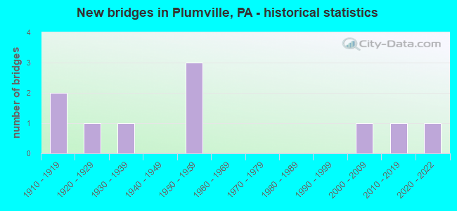
- New bridges - historical statistics
- 21910-1919
- 11920-1929
- 11930-1939
- 31950-1959
- 12000-2009
- 12010-2019
- 12020-2022

- Reconstructed bridges - Historical Statistics
- 11950-1959
- 01960-1969
- 01970-1979
- 01980-1989
- 01990-1999
- 22000-2009


- Bridge Condition - Deck
- 33.3%Good
- 50.0%Satisfactory
- 16.7%Fair

- Bridge Condition - Superstructure
- 12.5%Good
- 12.5%Satisfactory
- 62.5%Fair
- 12.5%Poor

- Bridge Condition - Substructure
- 25.0%Good
- 50.0%Satisfactory
- 25.0%Poor

- Bridge Condition - Channel
- 20.0%Very good
- 10.0%Good
- 30.0%Satisfactory
- 30.0%Fair
- 10.0%Poor
Find on map >> Show street view
Structure Number: 3358, Location: 600 feet south of SR-1026 (Lat: 40.823614, Lng: -79.229817), Route carried "on" structure: City street , Year Built: 1918, Status: Posted for load, Structure Length: 0.76m (2.49ft), Average Daily Traffic: 31 (year 2009), Truck Traffic: 9%, Average Future Daily Traffic: 35 (year 2029), Design Load: H 20, Features Intersected: COWANSHANNOCK CREEK, Facility Carried by Structure: T-720 MILLER ROAD
Minimum Vertical Clearance: 30+ m (98+ ft), Kilometerpoint: 0.000, Lanes on structure: 2, Owner: Town or Township Highway Agency, Approaching Roadway Width: 4.6m (15.1ft), Material/Design: Steel, Design/Construction: Stringer/Multi-beam, Number Of Spans In Main Unit: 1, Length of Maximum Span: 6.1m (20.0ft), Curb-To-Curb Width: 5.7m (18.7ft), Out-to-Out Width: 6.1m (20.0ft)
Condition: Deck: Good, Superstructure: Fair, Substructure: Good, Channel: Satisfactory, Operating Rating: 19.1 metric tons, Method Used To Determine Operating Rating: Load Factor (LF), Inventory Rating: 10.9 metric tons, Method Used To Determine Inventory Rating: Load Factor (LF), Structural Evaluation: Meets minimum limits, Deck Geometry: Meets minimum limits, Waterway Adequacy: Better than present minimum criteria, Approach Roadway Alignment: Equal to present desirable criteria, Bridge Posting: Required (Relationship of Operating Rating to Maximum Legal Load: > 39.9% below), Length Of Structure Improvement: 1.00m (3.28ft), Designated Inspection Frequency: Every 24 months, Other Special Inspection Frequency: Every 12 months, Inspection Date: March 2021, Other Special Inspection Date: March 2021, Bridge Improvement Cost: $23,000, Roadway Improvement Cost: $122,000, Total Project Cost: $311,000, Deck Structure Type: Concrete Cast-file-Place, Wearing Surface/Protective System: Wearing Surface: Monolithic Concrete
Find on map >> Show street view
Structure Number: 18994, Location: HILLTOP (Lat: 40.768978, Lng: -79.150644), Route carried "on" structure: State highway 85, Year Built: 1959, Year Reconstructed: 2008, Status: Open, Structure Length: 0.94m (3.08ft), Average Daily Traffic: 1,932 (year 2020), Truck Traffic: 12%, Average Future Daily Traffic: 3,521 (year 2032), Design Load: HS 20, Features Intersected: TRIB S BR PLUM CREEK
Minimum Vertical Clearance: 30+ m (98+ ft), Kilometerpoint: 8.530, Lanes on structure: 2, Base Highway Network: Yes, Owner: State Highway Agency, Approaching Roadway Width: 7.9m (25.9ft), Skew: 3 degrees, Material/Design: Prestressed concrete, Design/Construction: Box Beam or Girders - Multiple, Number Of Spans In Main Unit: 1, Length of Maximum Span: 8.8m (28.9ft), Curb-To-Curb Width: 11.5m (37.7ft), Out-to-Out Width: 13.3m (43.6ft)
Condition: Deck: Satisfactory, Superstructure: Fair, Substructure: Satisfactory, Channel: Fair, Operating Rating: 51.7 metric tons, Method Used To Determine Operating Rating: Load Factor (LF), Inventory Rating: 5.4 metric tons, Method Used To Determine Inventory Rating: Load Factor (LF), Structural Evaluation: High priority of corrective action, Deck Geometry: Equal to present minimum criteria, Waterway Adequacy: Equal to present minimum criteria, Approach Roadway Alignment: Equal to present desirable criteria, Length Of Structure Improvement: 1.60m (5.25ft), Designated Inspection Frequency: Every 24 months, Inspection Date: January 2021, Bridge Improvement Cost: $17,000, Roadway Improvement Cost: $75,000, Total Project Cost: $226,000, Deck Structure Type: Concrete Cast-file-Place, Wearing Surface/Protective System: Wearing Surface: Monolithic Concrete, Deck Protection: Epoxy Coated Reinforcing
Find on map >> Show street view
Structure Number: 18995, Location: AMBROSE HOLLOW (Lat: 40.759764, Lng: -79.138328), Route carried "on" structure: State highway 85, Year Built: 1959, Year Reconstructed: 2008, Status: Open, Structure Length: 1.89m (6.20ft), Average Daily Traffic: 1,932 (year 2020), Truck Traffic: 12%, Average Future Daily Traffic: 3,521 (year 2032), Design Load: HS 20, Features Intersected: SOUTH BRANCH PLUM CREEK
Minimum Vertical Clearance: 30+ m (98+ ft), Kilometerpoint: 9.640, Lanes on structure: 2, Base Highway Network: Yes, Owner: State Highway Agency, Approaching Roadway Width: 8.2m (26.9ft), Skew: 3 degrees, Material/Design: Prestressed concrete, Design/Construction: Box Beam or Girders - Multiple, Number Of Spans In Main Unit: 1, Length of Maximum Span: 18.0m (59.1ft), Curb-To-Curb Width: 11.8m (38.7ft), Out-to-Out Width: 13.4m (44.0ft)
Condition: Deck: Satisfactory, Superstructure: Fair, Substructure: Satisfactory, Channel: Fair, Operating Rating: 59.0 metric tons, Method Used To Determine Operating Rating: Load Factor (LF), Structural Evaluation: High priority of replacement, Deck Geometry: Equal to present minimum criteria, Waterway Adequacy: Equal to present minimum criteria, Approach Roadway Alignment: Equal to present desirable criteria, Length Of Structure Improvement: 2.60m (8.53ft), Designated Inspection Frequency: Every 24 months, Inspection Date: Febuary 2021, Bridge Improvement Cost: $36,000, Roadway Improvement Cost: $107,000, Total Project Cost: $489,000, Deck Structure Type: Concrete Cast-file-Place, Wearing Surface/Protective System: Wearing Surface: Monolithic Concrete, Deck Protection: Epoxy Coated Reinforcing
Find on map >> Show street view
Structure Number: 19054, Location: ROSSMOYNE NO.3 (Lat: 40.824933, Lng: -79.126864), Route carried "on" structure: State highway 210, Year Built: 1929, Status: Open, Structure Length: 0.82m (2.69ft), Average Daily Traffic: 1,809 (year 2021), Truck Traffic: 20%, Average Future Daily Traffic: 2,320 (year 2032), Design Load: H 20, Features Intersected: ROSS RUN
Minimum Vertical Clearance: 30+ m (98+ ft), Kilometerpoint: 5.815, Lanes on structure: 2, Owner: State Highway Agency, Approaching Roadway Width: 7.9m (25.9ft), Skew: 1 degrees, Material/Design: Concrete, Design/Construction: Arch - Deck, Number Of Spans In Main Unit: 1, Length of Maximum Span: 7.3m (24.0ft), Curb-To-Curb Width: 9.3m (30.5ft), Out-to-Out Width: 10.1m (33.1ft)
Condition: Superstructure: Poor, Substructure: Poor, Channel: Satisfactory, Operating Rating: 32.7 metric tons, Method Used To Determine Operating Rating: Field evaluation and documented engineering judgment, Inventory Rating: 19.1 metric tons, Method Used To Determine Inventory Rating: Field evaluation and documented engineering judgment, Structural Evaluation: Meets minimum limits, Deck Geometry: Somewhat better than minimum adequacy, Waterway Adequacy: Equal to present desirable criteria, Approach Roadway Alignment: Equal to present desirable criteria, Length Of Structure Improvement: 0.80m (2.62ft), Designated Inspection Frequency: Every 24 months, Inspection Date: Febuary 2021, Bridge Improvement Cost: $10,000, Roadway Improvement Cost: $37,000, Total Project Cost: $135,000
Find on map >> Show street view
Structure Number: 19383, Location: GOOSE RUN NO.2 (Lat: 40.770028, Lng: -79.120439), Route carried "on" structure: State highway , Year Built: 1939, Status: Open, Structure Length: 0.88m (2.89ft), Average Daily Traffic: 539 (year 2020), Truck Traffic: 1%, Average Future Daily Traffic: 331 (year 2032), Design Load: H 20, Features Intersected: GOOSE RUN, Facility Carried by Structure: SR4006
Minimum Vertical Clearance: 30+ m (98+ ft), Kilometerpoint: 9.025, Lanes on structure: 2, Owner: State Highway Agency, Approaching Roadway Width: 5.2m (17.1ft), Skew: 1 degrees, Material/Design: Concrete, Design/Construction: Tee Beam, Number Of Spans In Main Unit: 1, Length of Maximum Span: 8.5m (27.9ft), Curb-To-Curb Width: 6.9m (22.6ft), Out-to-Out Width: 7.9m (25.9ft)
Condition: Deck: Satisfactory, Superstructure: Fair, Substructure: Satisfactory, Channel: Poor, Operating Rating: 66.2 metric tons, Method Used To Determine Operating Rating: Load Factor (LF), Inventory Rating: 39.9 metric tons, Method Used To Determine Inventory Rating: Load Factor (LF), Structural Evaluation: Somewhat better than minimum adequacy, Deck Geometry: Meets minimum limits, Waterway Adequacy: Better than present minimum criteria, Approach Roadway Alignment: Equal to present desirable criteria, Length Of Structure Improvement: 1.60m (5.25ft), Designated Inspection Frequency: Every 24 months, Inspection Date: Febuary 2021, Bridge Improvement Cost: $8,000, Roadway Improvement Cost: $62,000, Total Project Cost: $111,000, Deck Structure Type: Concrete Cast-file-Place, Wearing Surface/Protective System: Wearing Surface: Bituminous
Find on map >> Show street view
Structure Number: 195, Location: CO#20 AT END OF T373 (Lat: 40.831208, Lng: -79.125267), Route carried "on" structure: City street , Year Built: 1918, Year Reconstructed: 1958, Status: Posted for load, Structure Length: 0.91m (2.99ft), Average Daily Traffic: 50 (year 2021), Truck Traffic: 10%, Average Future Daily Traffic: 65 (year 2041), Features Intersected: ROSS RUN, Facility Carried by Structure: T-373 FRANTZ RD
Minimum Vertical Clearance: 30+ m (98+ ft), Kilometerpoint: 0.000, Lanes on structure: 1, Owner: Town or Township Highway Agency, Approaching Roadway Width: 3.0m (9.8ft), Material/Design: Concrete, Design/Construction: Arch - Deck, Number Of Spans In Main Unit: 1, Length of Maximum Span: 9.1m (29.9ft), Curb or Sidewalk Widths: Left: 0.1m (0.3ft), Right: 0.1m (0.3ft), Curb-To-Curb Width: 4.0m (13.1ft), Out-to-Out Width: 5.0m (16.4ft)
Condition: Superstructure: Fair, Substructure: Satisfactory, Channel: Fair, Operating Rating: 8.2 metric tons, Method Used To Determine Operating Rating: Field evaluation and documented engineering judgment, Inventory Rating: 4.5 metric tons, Method Used To Determine Inventory Rating: Field evaluation and documented engineering judgment, Structural Evaluation: High priority of corrective action, Deck Geometry: Somewhat better than minimum adequacy, Waterway Adequacy: Better than present minimum criteria, Approach Roadway Alignment: Equal to present desirable criteria, Bridge Posting: Required (Relationship of Operating Rating to Maximum Legal Load: > 39.9% below), Length Of Structure Improvement: 1.40m (4.59ft), Designated Inspection Frequency: Every 24 months, Other Special Inspection Frequency: Every 12 months, Inspection Date: November 2019, Other Special Inspection Date: November 2020, Bridge Improvement Cost: $7,000, Roadway Improvement Cost: $21,000, Total Project Cost: $96,000
Find on map >> Show street view
Structure Number: 19506, Location: BTW SR4006 & T399 (Lat: 40.739131, Lng: -79.183103), Route carried "on" structure: City street 7220, Year Built: 1956, Status: Open, Structure Length: 1.10m (3.61ft), Average Daily Traffic: 100 (year 2017), Truck Traffic: 10%, Average Future Daily Traffic: 140 (year 2037), Design Load: HS 20, Features Intersected: REDDINGS RUN, Facility Carried by Structure: T-840 REDDING RUN
Minimum Vertical Clearance: 30+ m (98+ ft), Kilometerpoint: 0.000, Lanes on structure: 2, Owner: Town or Township Highway Agency, Approaching Roadway Width: 7.3m (24.0ft), Skew: 4 degrees, Material/Design: Steel, Design/Construction: Stringer/Multi-beam, Number Of Spans In Main Unit: 1, Length of Maximum Span: 10.4m (34.1ft), Curb or Sidewalk Widths: Left: 0.2m (0.7ft), Right: 0.2m (0.7ft), Curb-To-Curb Width: 7.3m (24.0ft), Out-to-Out Width: 7.6m (24.9ft)
Condition: Deck: Fair, Superstructure: Satisfactory, Substructure: Poor, Channel: Satisfactory, Operating Rating: 76.2 metric tons, Method Used To Determine Operating Rating: Load Factor (LF), Inventory Rating: 45.4 metric tons, Method Used To Determine Inventory Rating: Load Factor (LF), Structural Evaluation: Meets minimum limits, Deck Geometry: Equal to present minimum criteria, Waterway Adequacy: Better than present minimum criteria, Approach Roadway Alignment: Better than present minimum criteria, Length Of Structure Improvement: 1.70m (5.58ft), Designated Inspection Frequency: Every 24 months, Inspection Date: December 2019, Bridge Improvement Cost: $3,000, Roadway Improvement Cost: $9,000, Total Project Cost: $42,000, Deck Structure Type: Concrete Cast-file-Place, Wearing Surface/Protective System: Wearing Surface: Bituminous
Find on map >> Show street view
Structure Number: 48154, Location: 300 FT SOUTH OF SR 85 (Lat: 40.789042, Lng: -79.189789), Route carried "on" structure: City street , Year Built: 2003, Status: Open, Structure Length: 0.94m (3.08ft), Average Daily Traffic: 40 (year 2019), Truck Traffic: 1%, Average Future Daily Traffic: 45 (year 2039), Design Load: HS 25 or greater, Features Intersected: N. BR. PLUM CREEK, Facility Carried by Structure: OAK STREET
Minimum Vertical Clearance: 30+ m (98+ ft), Kilometerpoint: 0.000, Lanes on structure: 2, Owner: City or Municipal Highway Agency, Approaching Roadway Width: 5.2m (17.1ft), Material/Design: Concrete, Design/Construction: Slab, Number Of Spans In Main Unit: 1, Length of Maximum Span: 8.8m (28.9ft), Curb-To-Curb Width: 6.2m (20.3ft), Out-to-Out Width: 7.3m (24.0ft)
Condition: Deck: Good, Superstructure: Good, Substructure: Good, Channel: Good, Operating Rating: 49.0 metric tons, Method Used To Determine Operating Rating: Field evaluation and documented engineering judgment, Inventory Rating: 32.7 metric tons, Method Used To Determine Inventory Rating: Field evaluation and documented engineering judgment, Structural Evaluation: Better than present minimum criteria, Deck Geometry: Somewhat better than minimum adequacy, Waterway Adequacy: Better than present minimum criteria, Approach Roadway Alignment: Equal to present desirable criteria, Designated Inspection Frequency: Every 24 months, Inspection Date: October 2019, Wearing Surface/Protective System: Wearing Surface: Bituminous
Find on map >> Show street view
Structure Number: 54476, Location: 500 feet South of SR-0085 (Lat: 40.800347, Lng: -79.231997), Route carried "on" structure: City street , Year Built: 2017, Status: Open, Structure Length: 0.73m (2.40ft), Average Daily Traffic: 100 (year 2006), Truck Traffic: 9%, Average Future Daily Traffic: 140 (year 2026), Design Load: HL 93, Features Intersected: TRIB TO COWANSHANNOCK CR, Facility Carried by Structure: T-720 MILLER RD
Minimum Vertical Clearance: 30+ m (98+ ft), Kilometerpoint: 0.000, Lanes on structure: 2, Owner: Town or Township Highway Agency, Approaching Roadway Width: 7.0m (23.0ft), Material/Design: Concrete, Design/Construction: Culvert, Number Of Spans In Main Unit: 1, Length of Maximum Span: 6.7m (22.0ft), Curb-To-Curb Width: 6.9m (22.6ft), Out-to-Out Width: 8.1m (26.6ft)
Condition: Channel: Very good, Culverts: Very good, Operating Rating: 52.5 metric tons, Method Used To Determine Operating Rating: Assigned ratings based on Load and Resistance Factor Design (LRFD) reported by rating factor (RF) using HL93 loadings, Inventory Rating: 33.0 metric tons, Method Used To Determine Inventory Rating: Assigned ratings based on Load and Resistance Factor Design (LRFD) reported by rating factor (RF) using HL93 loadings, Structural Evaluation: Equal to present desirable criteria, Deck Geometry: Somewhat better than minimum adequacy, Waterway Adequacy: Superior to present desirable criteria, Approach Roadway Alignment: Equal to present desirable criteria, Designated Inspection Frequency: Every 24 months, Inspection Date: August 2021, Wearing Surface/Protective System: Wearing Surface: Monolithic Concrete, Deck Protection: Epoxy Coated Reinforcing
Find on map >> Show street view
Structure Number: 57156, Location: 350ft S SR 85 Intersect (Lat: 40.792300, Lng: -79.179972), Route carried "on" structure: State highway , Year Built: 2020, Status: Open, Structure Length: 0.79m (2.59ft), Average Daily Traffic: 478 (year 2022), Truck Traffic: 7%, Average Future Daily Traffic: 460 (year 2032), Design Load: HL 93, Features Intersected: North Br Plum Creek, Facility Carried by Structure: SR 4035
Minimum Vertical Clearance: 30+ m (98+ ft), Kilometerpoint: 0.000, Lanes on structure: 2, Owner: State Highway Agency, Approaching Roadway Width: 4.6m (15.1ft), Skew: 4 degrees, Material/Design: Concrete, Design/Construction: Culvert, Number Of Spans In Main Unit: 1, Length of Maximum Span: 7.3m (24.0ft), Curb or Sidewalk Widths: Left: 2.0m (6.6ft), Right: 0.1m (0.3ft), Curb-To-Curb Width: 9.8m (32.2ft), Out-to-Out Width: 13.4m (44.0ft)
Condition: Channel: Very good, Culverts: Very good, Operating Rating: 46.3 metric tons, Method Used To Determine Operating Rating: Assigned ratings based on Load and Resistance Factor Design (LRFD) reported by rating factor (RF) using HL93 loadings, Inventory Rating: 36.0 metric tons, Method Used To Determine Inventory Rating: Assigned ratings based on Load and Resistance Factor Design (LRFD) reported by rating factor (RF) using HL93 loadings, Structural Evaluation: Equal to present desirable criteria, Deck Geometry: Equal to present minimum criteria, Waterway Adequacy: Equal to present desirable criteria, Approach Roadway Alignment: Equal to present desirable criteria, Designated Inspection Frequency: Every 24 months, Inspection Date: October 2020, Wearing Surface/Protective System: Wearing Surface: Bituminous, Membrane: Preformed Fabric