Bridge Statistics for Pleasant Valley, West Virginia (WV)
Condition, Traffic, Stress, Structural Evaluation, Project Costs
- National Bridge Inventory (NBI) Statistics
- 17Number of bridges
- 344ft / 105mTotal length
- $7,612,000Total costs
- 215,180Total average daily traffic
- 32,499Total average daily truck traffic
- National Bridge Inventory (NBI) Registered Bridges for Pleasant Valley
- No street view available for this location
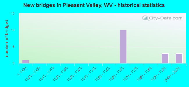
- New bridges - historical statistics
- 1Before 1900
- 101960-1969
- 31990-1999
- 32000-2009

- Reconstructed bridges - Historical Statistics
- 11980-1989
- 11990-1999


- Bridge Condition - Deck
- 37.5%Good
- 37.5%Satisfactory
- 25.0%Fair

- Bridge Condition - Superstructure
- 80.0%Good
- 20.0%Fair

- Bridge Condition - Substructure
- 40.0%Good
- 10.0%Satisfactory
- 50.0%Fair

- Bridge Condition - Channel
- 16.7%Excellent
- 50.0%Very good
- 33.3%Good
Find on map >> Show street view
Structure Number: 25A106, Location: 0.04 MI WEST CO RT 64 (Lat: 39.443050, Lng: -80.168250), Route carried "on" structure: County highway 6401, Year Built: 1966, Status: Open, Structure Length: 6.77m (22.21ft), Average Daily Traffic: 3,000 (year 2018), Truck Traffic: 9%, Average Future Daily Traffic: 3,700 (year 2038), Design Load: HS 20, Features Intersected: I 79 NB and SB, Facility Carried by Structure: MARION CO RT 64/1
Minimum Vertical Clearance: 30+ m (98+ ft), Kilometerpoint: 0.064, Lanes on structure: 2, Lanes under structure: 4, Owner: State Highway Agency, Approaching Roadway Width: 12.2m (40.0ft), Material/Design: Steel continuous, Design/Construction: Stringer/Multi-beam, Number Of Spans In Main Unit: 2, Number Of Approach Spans: 2, Length of Maximum Span: 18.1m (59.4ft), Curb or Sidewalk Widths: Left: 0.5m (1.6ft), Right: 0.5m (1.6ft), Curb-To-Curb Width: 7.9m (25.9ft), Out-to-Out Width: 9.4m (30.8ft)
Condition: Deck: Fair, Superstructure: Fair, Substructure: Fair, Operating Rating: 74.4 metric tons, Method Used To Determine Operating Rating: Load Factor (LF), Inventory Rating: 44.4 metric tons, Method Used To Determine Inventory Rating: Load Factor (LF), Structural Evaluation: Somewhat better than minimum adequacy, Deck Geometry: High priority of corrective action, Underclear: Equal to present minimum criteria, Approach Roadway Alignment: Better than present minimum criteria, Length Of Structure Improvement: 6.77m (22.21ft), Designated Inspection Frequency: Every 24 months, Inspection Date: August 2020, Bridge Improvement Cost: $234,000, Roadway Improvement Cost: $101,000, Total Project Cost: $379,000 ( Estimate for 2020), Deck Structure Type: Concrete Cast-file-Place, Wearing Surface/Protective System: Wearing Surface: Monolithic Concrete
Find on map >> Show street view
Structure Number: 25A109, Location: 0.01 MI EAST CO RT 62/4 (Lat: 39.435619, Lng: -80.133069), Route carried "on" structure: County highway 6200, Year Built: 1993, Status: Open, Structure Length: 11.66m (38.25ft), Average Daily Traffic: 1,000 (year 2018), Truck Traffic: 9%, Average Future Daily Traffic: 1,230 (year 2038), Design Load: HS 25 or greater, Features Intersected: TYGART VALLEY RIVER, Facility Carried by Structure: MARION CO RT 62
Minimum Vertical Clearance: 30+ m (98+ ft), Kilometerpoint: 4.892, Lanes on structure: 2, Owner: State Highway Agency, Approaching Roadway Width: 7.9m (25.9ft), Skew: 1 degrees, Navigation Control: Yes ( Vertical Clearance: 6.4m (21.0ft), Horizontal Clearance: 39.6m (129.9ft)), Material/Design: Steel continuous, Design/Construction: Stringer/Multi-beam, Number Of Spans In Main Unit: 1, Number Of Approach Spans: 2, Length of Maximum Span: 44.2m (145.0ft), Curb-To-Curb Width: 8.2m (26.9ft), Out-to-Out Width: 9.2m (30.2ft)
Condition: Deck: Satisfactory, Superstructure: Good, Substructure: Fair, Channel: Good, Operating Rating: 88.9 metric tons, Method Used To Determine Operating Rating: Load Factor (LF), Inventory Rating: 86.2 metric tons, Method Used To Determine Inventory Rating: Load Factor (LF), Structural Evaluation: Somewhat better than minimum adequacy, Deck Geometry: Somewhat better than minimum adequacy, Waterway Adequacy: Superior to present desirable criteria, Approach Roadway Alignment: Equal to present minimum criteria, Designated Inspection Frequency: Every 24 months, Underwater Inspection Frequency: Every 60 months, Inspection Date: May 2020, Underwater Inspection Date: August 2020, Deck Structure Type: Concrete Cast-file-Place, Wearing Surface/Protective System: Wearing Surface: Monolithic Concrete, Deck Protection: Epoxy Coated Reinforcing
Find on map >> Show street view
Structure Number: 25A135, Location: 0.53 MI SOUTH CO RT 64/1 (Lat: 39.439561, Lng: -80.174800), Route carried "on" structure: Interstate 7900, Year Built: 1966, Year Reconstructed: 1994, Status: Open, Structure Length: 26.94m (88.39ft), Average Daily Traffic: 24,750 (year 2019), Truck Traffic: 14%, Average Future Daily Traffic: 33,660 (year 2041), Design Load: HS 20, Features Intersected: Tygart River,Mar.60,CSX, Facility Carried by Structure: INTERSTATE 79 NB
Minimum Vertical Clearance: 30+ m (98+ ft), Kilometerpoint: 213.785, Lanes on structure: 2, Lanes under structure: 1, Base Highway Network: Yes, Owner: State Highway Agency, Approaching Roadway Width: 11.6m (38.1ft), Material/Design: Steel, Design/Construction: Arch - Deck, Number Of Spans In Main Unit: 1, Number Of Approach Spans: 12, Length of Maximum Span: 100.6m (330.1ft), Curb-To-Curb Width: 9.6m (31.5ft), Out-to-Out Width: 10.7m (35.1ft)
Condition: Deck: Good, Superstructure: Good, Substructure: Fair, Channel: Very good, Operating Rating: 82.5 metric tons, Method Used To Determine Operating Rating: Load Factor (LF), Inventory Rating: 32.7 metric tons, Method Used To Determine Inventory Rating: Load Factor (LF), Structural Evaluation: Somewhat better than minimum adequacy, Deck Geometry: Meets minimum limits, Underclear: Meets minimum limits, Waterway Adequacy: Superior to present desirable criteria, Approach Roadway Alignment: Equal to present desirable criteria, Designated Inspection Frequency: Every 24 months, Critical Feature Inspection Frequency: Every 24 months, Inspection Date: March 2021, Critical Feature Inspection Date: March 2021, Deck Structure Type: Concrete Cast-file-Place, Wearing Surface/Protective System: Wearing Surface: Monolithic Concrete, Deck Protection: Epoxy Coated Reinforcing
Find on map >> Show street view
Structure Number: 25A136, Location: 0.53 MI SOUTH CO RT 64/1 (Lat: 39.439681, Lng: -80.174850), Route carried "on" structure: Interstate 7900, Year Built: 1960, Year Reconstructed: 1995, Status: Open, Structure Length: 26.94m (88.39ft), Average Daily Traffic: 25,200 (year 2018), Truck Traffic: 18%, Average Future Daily Traffic: 36,300 (year 2038), Design Load: HS 20, Features Intersected: Tygart Valley Riv, CR 60, Facility Carried by Structure: INTERSTATE 79 SB
Minimum Vertical Clearance: 30+ m (98+ ft), Kilometerpoint: 213.785, Lanes on structure: 2, Lanes under structure: 1, Base Highway Network: Yes, Owner: State Highway Agency, Approaching Roadway Width: 11.6m (38.1ft), Material/Design: Steel, Design/Construction: Arch - Deck, Number Of Spans In Main Unit: 1, Number Of Approach Spans: 13, Length of Maximum Span: 100.6m (330.1ft), Curb-To-Curb Width: 9.6m (31.5ft), Out-to-Out Width: 10.7m (35.1ft)
Condition: Deck: Fair, Superstructure: Fair, Substructure: Fair, Channel: Very good, Operating Rating: 71.7 metric tons, Method Used To Determine Operating Rating: Load Factor (LF), Inventory Rating: 32.7 metric tons, Method Used To Determine Inventory Rating: Load Factor (LF), Structural Evaluation: Somewhat better than minimum adequacy, Deck Geometry: Meets minimum limits, Underclear: High priority of replacement, Waterway Adequacy: Superior to present desirable criteria, Approach Roadway Alignment: Equal to present desirable criteria, Length Of Structure Improvement: 27.77m (91.11ft), Designated Inspection Frequency: Every 24 months, Critical Feature Inspection Frequency: Every 24 months, Inspection Date: July 2020, Critical Feature Inspection Date: July 2020, Bridge Improvement Cost: $3,182,000, Roadway Improvement Cost: $1,211,000, Total Project Cost: $5,348,000 ( Estimate for 2020), Deck Structure Type: Concrete Cast-file-Place, Wearing Surface/Protective System: Wearing Surface: Monolithic Concrete, Deck Protection: Epoxy Coated Reinforcing
Find on map >> Show street view
Structure Number: 25A137, Location: 1.57 MI NORTH CO RT 64/1 (Lat: 39.456900, Lng: -80.145139), Route carried "on" structure: Interstate 7900, Year Built: 1965, Status: Open, Structure Length: 4.12m (13.52ft), Average Daily Traffic: 24,350 (year 2019), Truck Traffic: 14%, Average Future Daily Traffic: 33,120 (year 2038), Design Load: HS 20, Features Intersected: Marion County Rt. 64/2, Facility Carried by Structure: INTERSTATE 79 NB
Minimum Vertical Clearance: 30+ m (98+ ft), Kilometerpoint: 217.165, Lanes on structure: 2, Lanes under structure: 2, Base Highway Network: Yes, Owner: State Highway Agency, Approaching Roadway Width: 11.3m (37.1ft), Skew: 1 degrees, Material/Design: Steel continuous, Design/Construction: Stringer/Multi-beam, Number Of Spans In Main Unit: 1, Number Of Approach Spans: 2, Length of Maximum Span: 15.7m (51.5ft), Curb-To-Curb Width: 11.2m (36.7ft), Out-to-Out Width: 12.3m (40.4ft)
Condition: Deck: Satisfactory, Superstructure: Good, Substructure: Satisfactory, Operating Rating: 68.9 metric tons, Method Used To Determine Operating Rating: Load Factor (LF), Inventory Rating: 41.7 metric tons, Method Used To Determine Inventory Rating: Load Factor (LF), Structural Evaluation: Equal to present minimum criteria, Deck Geometry: Somewhat better than minimum adequacy, Underclear: Meets minimum limits, Approach Roadway Alignment: Equal to present desirable criteria, Length Of Structure Improvement: 4.11m (13.48ft), Designated Inspection Frequency: Every 24 months, Inspection Date: August 2021, Bridge Improvement Cost: $624,000, Roadway Improvement Cost: $134,000, Total Project Cost: $948,000 ( Estimate for 2021), Deck Structure Type: Concrete Cast-file-Place, Wearing Surface/Protective System: Wearing Surface: Latex Concrete
Find on map >> Show street view
Structure Number: 25A138, Location: 1.57 MI NORTH CO RT 64/1 (Lat: 39.456961, Lng: -80.145381), Route carried "on" structure: Interstate 7900, Year Built: 1965, Status: Open, Structure Length: 4.12m (13.52ft), Average Daily Traffic: 24,350 (year 2019), Truck Traffic: 14%, Average Future Daily Traffic: 33,120 (year 2041), Design Load: HS 20, Features Intersected: Marion County Rt. 64/2, Facility Carried by Structure: INTERSTATE 79 SB
Minimum Vertical Clearance: 30+ m (98+ ft), Kilometerpoint: 217.165, Lanes on structure: 2, Lanes under structure: 2, Base Highway Network: Yes, Owner: State Highway Agency, Approaching Roadway Width: 11.3m (37.1ft), Skew: 1 degrees, Material/Design: Steel continuous, Design/Construction: Stringer/Multi-beam, Number Of Spans In Main Unit: 1, Number Of Approach Spans: 2, Length of Maximum Span: 15.7m (51.5ft), Curb-To-Curb Width: 11.2m (36.7ft), Out-to-Out Width: 12.3m (40.4ft)
Condition: Deck: Satisfactory, Superstructure: Good, Substructure: Fair, Operating Rating: 68.9 metric tons, Method Used To Determine Operating Rating: Load Factor (LF), Inventory Rating: 41.7 metric tons, Method Used To Determine Inventory Rating: Load Factor (LF), Structural Evaluation: Somewhat better than minimum adequacy, Deck Geometry: Somewhat better than minimum adequacy, Underclear: Better than present minimum criteria, Approach Roadway Alignment: Equal to present desirable criteria, Length Of Structure Improvement: 4.11m (13.48ft), Designated Inspection Frequency: Every 24 months, Inspection Date: August 2021, Bridge Improvement Cost: $598,000, Roadway Improvement Cost: $117,000, Total Project Cost: $937,000 ( Estimate for 2021), Deck Structure Type: Concrete Cast-file-Place, Wearing Surface/Protective System: Wearing Surface: Latex Concrete
Find on map >> Show street view
Structure Number: 25A22, Location: 0.07 MI NORTH CO RT 66 (Lat: 39.436350, Lng: -80.130461), Route carried "on" structure: County highway 3101, Year Built: 1996, Status: Open, Structure Length: 0.94m (3.08ft), Average Daily Traffic: 250 (year 2019), Truck Traffic: 8%, Average Future Daily Traffic: 390 (year 2041), Design Load: HS 25 or greater, Features Intersected: GUYSES RUN, Facility Carried by Structure: MARION CO RT 31/1
Minimum Vertical Clearance: 30+ m (98+ ft), Kilometerpoint: 0.113, Lanes on structure: 2, Owner: State Highway Agency, Approaching Roadway Width: 4.0m (13.1ft), Material/Design: Prestressed concrete, Design/Construction: Box Beam or Girders - Multiple, Number Of Spans In Main Unit: 1, Length of Maximum Span: 7.9m (25.9ft), Curb-To-Curb Width: 6.3m (20.7ft), Out-to-Out Width: 6.5m (21.3ft)
Condition: Superstructure: Good, Substructure: Good, Channel: Very good, Operating Rating: 88.9 metric tons, Method Used To Determine Operating Rating: Load Factor (LF), Inventory Rating: 63.5 metric tons, Method Used To Determine Inventory Rating: Load Factor (LF), Structural Evaluation: Better than present minimum criteria, Deck Geometry: Meets minimum limits, Waterway Adequacy: Equal to present desirable criteria, Approach Roadway Alignment: Better than present minimum criteria, Designated Inspection Frequency: Every 48 months, Inspection Date: April 2021, Deck Structure Type: Other, Wearing Surface/Protective System: Wearing Surface: Bituminous, Deck Protection: Epoxy Coated Reinforcing
Find on map >> Show street view
Structure Number: 25A221, Location: 0.41 MI NORTH CO RT 31/17 (Lat: 39.446689, Lng: -80.129939), Route carried "on" structure: County highway 3101, Year Built: 1996, Status: Open, Structure Length: 0.73m (2.40ft), Average Daily Traffic: 250 (year 2018), Truck Traffic: 9%, Average Future Daily Traffic: 300 (year 2038), Design Load: HS 25 or greater, Features Intersected: ROBINSON RUN, Facility Carried by Structure: MARION CO RT 31/1
Minimum Vertical Clearance: 30+ m (98+ ft), Kilometerpoint: 1.239, Lanes on structure: 1, Owner: State Highway Agency, Approaching Roadway Width: 3.7m (12.1ft), Skew: 4 degrees, Material/Design: Concrete, Design/Construction: Frame, Number Of Spans In Main Unit: 1, Length of Maximum Span: 6.5m (21.3ft), Curb-To-Curb Width: 4.3m (14.1ft), Out-to-Out Width: 5.0m (16.4ft)
Condition: Superstructure: Good, Substructure: Good, Channel: Good, Operating Rating: 88.9 metric tons, Method Used To Determine Operating Rating: Field evaluation and documented engineering judgment, Inventory Rating: 40.8 metric tons, Method Used To Determine Inventory Rating: Field evaluation and documented engineering judgment, Structural Evaluation: Better than present minimum criteria, Deck Geometry: High priority of replacement, Waterway Adequacy: Equal to present minimum criteria, Approach Roadway Alignment: Equal to present minimum criteria, Designated Inspection Frequency: Every 24 months, Inspection Date: June 2020, Deck Structure Type: Concrete Cast-file-Place, Wearing Surface/Protective System: Wearing Surface: Bituminous, Deck Protection: Epoxy Coated Reinforcing
Find on map >> Show street view
Structure Number: 25A248, Location: 0.10 MI NORTH CO RT 60 (Lat: 39.435269, Lng: -80.172789), Route carried "on" structure: County highway 6400, Year Built: 2001, Status: Open, Structure Length: 15.96m (52.36ft), Average Daily Traffic: 2,500 (year 2019), Truck Traffic: 8%, Average Future Daily Traffic: 3,875 (year 2041), Design Load: HS 25 or greater, Features Intersected: Tygart River & CSX RR, Facility Carried by Structure: MARION CO RT 64
Minimum Vertical Clearance: 30+ m (98+ ft), Kilometerpoint: 0.016, Lanes on structure: 2, Lanes under structure: 2, Owner: State Highway Agency, Approaching Roadway Width: 11.3m (37.1ft), Navigation Control: Yes ( Vertical Clearance: 14.0m (45.9ft), Horizontal Clearance: 36.6m (120.1ft)), Material/Design: Prestressed concrete continuous, Design/Construction: Stringer/Multi-beam, Number Of Spans In Main Unit: 4, Length of Maximum Span: 39.6m (129.9ft), Curb-To-Curb Width: 9.1m (29.9ft), Out-to-Out Width: 9.9m (32.5ft)
Condition: Deck: Good, Superstructure: Good, Substructure: Good, Channel: Excellent, Operating Rating: 76.2 metric tons, Method Used To Determine Operating Rating: Load Factor (LF), Inventory Rating: 45.4 metric tons, Method Used To Determine Inventory Rating: Load Factor (LF), Structural Evaluation: Better than present minimum criteria, Deck Geometry: Meets minimum limits, Underclear: Equal to present minimum criteria, Waterway Adequacy: Superior to present desirable criteria, Approach Roadway Alignment: Equal to present minimum criteria, Designated Inspection Frequency: Every 24 months, Underwater Inspection Frequency: Every 60 months, Inspection Date: November 2021, Underwater Inspection Date: September 2018, Deck Structure Type: Concrete Cast-file-Place, Wearing Surface/Protective System: Deck Protection: Epoxy Coated Reinforcing
Find on map >> Show street view
Structure Number: 25A26, Location: 0.68 MI NORTH MRN CO 64/2 (Lat: 39.464369, Lng: -80.136631), Route carried "on" structure: Interstate 7900, Year Built: 2008, Status: Open, Structure Length: 6.64m (21.78ft), Average Daily Traffic: 53,700 (year 2019), Truck Traffic: 14%, Average Future Daily Traffic: 73,030 (year 2041), Design Load: HL 93, Features Intersected: Mar. Co. Rt. 64, Facility Carried by Structure: INTERSTATE 79
Minimum Vertical Clearance: 30+ m (98+ ft), Kilometerpoint: 218.259, Lanes on structure: 6, Lanes under structure: 2, Base Highway Network: Yes, Owner: State Highway Agency, Approaching Roadway Width: 41.5m (136.2ft), Skew: 33 degrees, Material/Design: Steel continuous, Design/Construction: Stringer/Multi-beam, Number Of Spans In Main Unit: 1, Number Of Approach Spans: 2, Length of Maximum Span: 25.0m (82.0ft), Curb-To-Curb Width: 40.8m (133.9ft), Out-to-Out Width: 42.2m (138.5ft)
Condition: Deck: Good, Superstructure: Good, Substructure: Good, Operating Rating: 31.7 metric tons, Method Used To Determine Operating Rating: Load and Resistance Factor (LRFR), Inventory Rating: 24.5 metric tons, Method Used To Determine Inventory Rating: Load and Resistance Factor (LRFR), Structural Evaluation: Equal to present minimum criteria, Deck Geometry: Superior to present desirable criteria, Underclear: Equal to present minimum criteria, Approach Roadway Alignment: Superior to present desirable criteria, Designated Inspection Frequency: Every 24 months, Inspection Date: July 2021, Deck Structure Type: Concrete Cast-file-Place, Wearing Surface/Protective System: Deck Protection: Epoxy Coated Reinforcing
Find on map >> Show street view
Structure Number: 25A106, Location: 0.04 MI WEST CO RT 64 (Lat: 39.443050, Lng: -80.168250), Route carried "under" structure: Interstate 7900, Year Built: 1966, Structure Length: 0. m, Average Daily Traffic: 50,400 (year 0018), Truck Traffic: 18%, Features Intersected: I 79 NB and SB, Facility Carried by Structure: MARION CO RT 64/1
Minimum Vertical Clearance: 5.74m (18.83ft), Kilometerpoint: 214.638, Lanes on structure: 2, Lanes under structure: 4, Length of Maximum Span: 18.1m (59.4ft)
Find on map >> Show street view
Structure Number: 25A135, Location: 0.53 MI SOUTH CO RT 64/1 (Lat: 39.439561, Lng: -80.174800), Route carried "under" structure: County highway 6000, Year Built: 1966, Structure Length: 0. m, Average Daily Traffic: 2,425 (year 0017), Truck Traffic: 9%, Features Intersected: Tygart River,Mar.60,CSX, Facility Carried by Structure: INTERSTATE 79 NB
Minimum Vertical Clearance: 8.38m (27.49ft), Kilometerpoint: 7.483, Lanes on structure: 2, Lanes under structure: 2, Length of Maximum Span: 100.6m (330.1ft)
Find on map >> Show street view
Structure Number: 25A136, Location: 0.53 MI SOUTH CO RT 64/1 (Lat: 39.439681, Lng: -80.174850), Route carried "under" structure: County highway 6000, Year Built: 1960, Structure Length: 0. m, Average Daily Traffic: 2,400 (year 0018), Truck Traffic: 9%, Features Intersected: Tygart Valley Riv, CR 60, Facility Carried by Structure: INTERSTATE 79 SB
Minimum Vertical Clearance: 8.28m (27.17ft), Kilometerpoint: 7.483, Lanes on structure: 2, Lanes under structure: 2, Length of Maximum Span: 100.6m (330.1ft)
Find on map >> Show street view
Structure Number: 25A137, Location: 1.57 MI NORTH CO RT 64/1 (Lat: 39.456889, Lng: -80.145150), Route carried "under" structure: County highway 6402, Year Built: 1965, Structure Length: 0. m, Average Daily Traffic: 300 (year 0018), Truck Traffic: 9%, Features Intersected: Marion County Rt. 64/2, Facility Carried by Structure: INTERSTATE 79 NB
Minimum Vertical Clearance: 4.57m (14.99ft), Kilometerpoint: 0.322, Lanes on structure: 2, Lanes under structure: 2, Length of Maximum Span: 15.7m (51.5ft)
Find on map >> Show street view
Structure Number: 25A138, Location: 1.57 MI NORTH CO RT 64/1 (Lat: 39.456961, Lng: -80.145389), Route carried "under" structure: County highway 6402, Year Built: 1965, Structure Length: 0. m, Average Daily Traffic: 300 (year 0018), Truck Traffic: 9%, Features Intersected: Marion County Rt. 64/2, Facility Carried by Structure: INTERSTATE 79 SB
Minimum Vertical Clearance: 5.00m (16.40ft), Kilometerpoint: 0.322, Lanes on structure: 2, Lanes under structure: 2, Length of Maximum Span: 15.7m (51.5ft)
Find on map >> Show street view
Structure Number: 25A156, Location: 0.02 MI EAST MAR CO 88 (Lat: 39.408169, Lng: -80.103361), Route carried "under" structure: County highway 8600, Year Built: 1895, Structure Length: 0. m, Features Intersected: CSX CORP RAILROAD, Facility Carried by Structure: CSX CORP RAILROAD
Minimum Vertical Clearance: 7.32m (24.02ft), Kilometerpoint: 0.032, Lanes under structure: 2, Length of Maximum Span: 7.6m (24.9ft)
Find on map >> Show street view
Structure Number: 25A248, Location: 0.10 MI NORTH CO RT 60 (Lat: 39.435269, Lng: -80.172789), Route carried "under" structure: Other road , Year Built: 2001, Structure Length: 0. m, Average Daily Traffic: 5 (year 0019), Features Intersected: Tygart River & CSX RR, Facility Carried by Structure: MARION CO RT 64
Minimum Vertical Clearance: 8.23m (27.00ft), Kilometerpoint: 0.000, Lanes on structure: 2, Lanes under structure: 1, Length of Maximum Span: 39.6m (129.9ft)