Bridge Statistics for Pleasant Springs, Wisconsin (WI)
Condition, Traffic, Stress, Structural Evaluation, Project Costs
- National Bridge Inventory (NBI) Statistics
- 26Number of bridges
- 233ft / 71.0mTotal length
- $1,774,000Total costs
- 454,765Total average daily traffic
- 63,585Total average daily truck traffic
- National Bridge Inventory (NBI) Registered Bridges for Pleasant Springs
- No street view available for this location
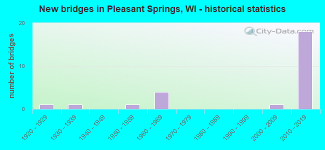
- New bridges - historical statistics
- 11920-1929
- 11930-1939
- 11950-1959
- 41960-1969
- 12000-2009
- 182010-2019

- Reconstructed bridges - Historical Statistics
- 21950-1959
- 01960-1969
- 01970-1979
- 01980-1989
- 01990-1999
- 12000-2009


- Bridge Condition - Deck
- 5.9%Excellent
- 41.2%Very good
- 23.5%Good
- 11.8%Satisfactory
- 5.9%Fair
- 5.9%Poor
- 5.9%Serious

- Bridge Condition - Superstructure
- 5.9%Excellent
- 35.3%Very good
- 29.4%Good
- 11.8%Satisfactory
- 5.9%Fair
- 5.9%Poor
- 5.9%Serious

- Bridge Condition - Substructure
- 5.9%Excellent
- 52.9%Very good
- 11.8%Good
- 17.6%Satisfactory
- 5.9%Poor
- 5.9%Serious

- Bridge Condition - Channel
- 14.3%Excellent
- 57.1%Very good
- 28.6%Satisfactory
Find on map >> Show street view
Structure Number: B130034, Location: 0.2M W JCT CTH N (Lat: 42.940444, Lng: -89.204056), Route carried "on" structure: County highway , Year Built: 1952, Year Reconstructed: 2012, Status: Open, Structure Length: 4.82m (15.81ft), Average Daily Traffic: 5,481 (year 2019), Average Future Daily Traffic: 6,029 (year 2039), Design Load: HL 93, Features Intersected: YAHARA RIVER, Facility Carried by Structure: CTH B
Minimum Vertical Clearance: 30+ m (98+ ft), Kilometerpoint: 0.000, Lanes on structure: 2, Owner: County Highway Agency, Approaching Roadway Width: 10.4m (34.1ft), Skew: 4 degrees, Material/Design: Prestressed concrete continuous, Design/Construction: Stringer/Multi-beam, Number Of Spans In Main Unit: 2, Length of Maximum Span: 22.9m (75.1ft), Curb-To-Curb Width: 10.4m (34.1ft), Out-to-Out Width: 11.1m (36.4ft)
Condition: Deck: Good, Superstructure: Very good, Substructure: Good, Channel: Very good, Operating Rating: 48.3 metric tons, Method Used To Determine Operating Rating: Load and Resistance Factor Rating (LRFR) rating reported by rating factor(RF) method using HL-93 loadings, Inventory Rating: 36.9 metric tons, Method Used To Determine Inventory Rating: Load and Resistance Factor Rating (LRFR) rating reported by rating factor(RF) method using HL-93 loadings, Structural Evaluation: Better than present minimum criteria, Deck Geometry: Meets minimum limits, Waterway Adequacy: Equal to present desirable criteria, Approach Roadway Alignment: Equal to present desirable criteria, Designated Inspection Frequency: Every 24 months, Underwater Inspection Frequency: Every 60 months, Inspection Date: November 2020, Underwater Inspection Date: November 2020, Deck Structure Type: Concrete Cast-file-Place, Wearing Surface/Protective System: Wearing Surface: Epoxy Overlay, Deck Protection: Epoxy Coated Reinforcing
Find on map >> Show street view
Structure Number: B130136, Location: 2.1M N JCT CTH B (Lat: 42.969167, Lng: -89.222750), Route carried "on" structure: City street , Year Built: 1960, Status: Open, Structure Length: 1.70m (5.58ft), Average Daily Traffic: 322 (year 2019), Average Future Daily Traffic: 354 (year 2039), Design Load: H 15, Features Intersected: YAHARA RIVER, Facility Carried by Structure: LRD WILLIAMS DR
Minimum Vertical Clearance: 30+ m (98+ ft), Kilometerpoint: 0.000, Lanes on structure: 2, Owner: Town or Township Highway Agency, Approaching Roadway Width: 9.1m (29.9ft), Material/Design: Steel, Design/Construction: Stringer/Multi-beam, Number Of Spans In Main Unit: 1, Length of Maximum Span: 16.8m (55.1ft), Curb-To-Curb Width: 7.9m (25.9ft), Out-to-Out Width: 9.6m (31.5ft)
Condition: Deck: Good, Superstructure: Satisfactory, Substructure: Satisfactory, Channel: Very good, Operating Rating: 22.9 metric tons, Method Used To Determine Operating Rating: Load Factor (LF), Inventory Rating: 13.0 metric tons, Method Used To Determine Inventory Rating: Load Factor (LF), Structural Evaluation: Meets minimum limits, Deck Geometry: Somewhat better than minimum adequacy, Waterway Adequacy: Equal to present desirable criteria, Approach Roadway Alignment: Equal to present desirable criteria, Designated Inspection Frequency: Every 24 months, Inspection Date: October 2020, Deck Structure Type: Concrete Cast-file-Place, Wearing Surface/Protective System: Wearing Surface: Bituminous
Find on map >> Show street view
Structure Number: B13025, Location: 0.3M W JCT CTH MM (Lat: 43.001364, Lng: -89.385236), Route carried "on" structure: City street , Year Built: 1969, Status: Open, Structure Length: 7.01m (23.00ft), Average Daily Traffic: 3,000 (year 2019), Average Future Daily Traffic: 330 (year 2039), Design Load: H 20, Features Intersected: USH 14, Facility Carried by Structure: LRD HAIGHT FARM RD
Minimum Vertical Clearance: 30+ m (98+ ft), Kilometerpoint: 0.000, Lanes on structure: 2, Lanes under structure: 4, Owner: State Highway Agency, Approaching Roadway Width: 12.2m (40.0ft), Skew: 1 degrees, Material/Design: Steel continuous, Design/Construction: Stringer/Multi-beam, Number Of Spans In Main Unit: 2, Length of Maximum Span: 34.6m (113.5ft), Curb-To-Curb Width: 10.4m (34.1ft), Out-to-Out Width: 11.3m (37.1ft)
Condition: Deck: Satisfactory, Superstructure: Good, Substructure: Satisfactory, Operating Rating: 37.6 metric tons, Method Used To Determine Operating Rating: Load Factor (LF), Inventory Rating: 21.1 metric tons, Method Used To Determine Inventory Rating: Load Factor (LF), Structural Evaluation: Somewhat better than minimum adequacy, Deck Geometry: Somewhat better than minimum adequacy, Underclear: Equal to present minimum criteria, Approach Roadway Alignment: Equal to present desirable criteria, Designated Inspection Frequency: Every 24 months, Inspection Date: June 2020, Deck Structure Type: Concrete Cast-file-Place, Wearing Surface/Protective System: Wearing Surface: Low Slump Concrete
Find on map >> Show street view
Structure Number: B130259, Location: 2.0M W JCT CTH N (Lat: 42.975806, Lng: -89.234167), Route carried "on" structure: City street , Year Built: 1967, Status: Open, Structure Length: 2.77m (9.09ft), Average Daily Traffic: 322 (year 2019), Average Future Daily Traffic: 354 (year 2039), Design Load: H 15, Features Intersected: LRD PARK RD, Facility Carried by Structure: LRD WILLIAMS POINT
Minimum Vertical Clearance: 30+ m (98+ ft), Kilometerpoint: 0.000, Lanes on structure: 2, Lanes under structure: 2, Owner: Town or Township Highway Agency, Approaching Roadway Width: 11.0m (36.1ft), Material/Design: Concrete continuous, Design/Construction: Slab, Number Of Spans In Main Unit: 3, Length of Maximum Span: 10.7m (35.1ft), Curb-To-Curb Width: 8.2m (26.9ft), Out-to-Out Width: 9.3m (30.5ft)
Condition: Deck: Fair, Superstructure: Fair, Substructure: Satisfactory, Operating Rating: 52.3 metric tons, Method Used To Determine Operating Rating: Load Factor (LF), Inventory Rating: 30.8 metric tons, Method Used To Determine Inventory Rating: Load Factor (LF), Structural Evaluation: Somewhat better than minimum adequacy, Deck Geometry: Somewhat better than minimum adequacy, Underclear: High priority of replacement, Approach Roadway Alignment: Equal to present desirable criteria, Length Of Structure Improvement: 3.23m (10.60ft), Designated Inspection Frequency: Every 24 months, Inspection Date: October 2020, Bridge Improvement Cost: $267,000, Roadway Improvement Cost: $26,000, Total Project Cost: $400,000 ( Estimate for 2021), Deck Structure Type: Concrete Cast-file-Place, Wearing Surface/Protective System: Wearing Surface: Monolithic Concrete
Find on map >> Show street view
Structure Number: B130565, Location: 0.8M N JCT CTH B (Lat: 42.948194, Lng: -89.200972), Route carried "on" structure: County highway , Year Built: 2004, Status: Open, Structure Length: 1.14m (3.74ft), Average Daily Traffic: 7,701 (year 2019), Truck Traffic: 5%, Average Future Daily Traffic: 8,471 (year 2039), Design Load: HS 20, Features Intersected: BR YAHARA RIVER, Facility Carried by Structure: CTH N
Minimum Vertical Clearance: 30+ m (98+ ft), Kilometerpoint: 0.000, Lanes on structure: 2, Owner: County Highway Agency, Approaching Roadway Width: 13.4m (44.0ft), Material/Design: Concrete, Design/Construction: Slab, Number Of Spans In Main Unit: 1, Length of Maximum Span: 11.4m (37.4ft), Curb-To-Curb Width: 13.4m (44.0ft), Out-to-Out Width: 14.0m (45.9ft)
Condition: Deck: Satisfactory, Superstructure: Satisfactory, Substructure: Very good, Channel: Satisfactory, Operating Rating: 62.1 metric tons, Method Used To Determine Operating Rating: Load Factor (LF), Inventory Rating: 37.3 metric tons, Method Used To Determine Inventory Rating: Load Factor (LF), Structural Evaluation: Equal to present minimum criteria, Deck Geometry: Equal to present minimum criteria, Waterway Adequacy: Equal to present desirable criteria, Approach Roadway Alignment: Equal to present desirable criteria, Designated Inspection Frequency: Every 24 months, Inspection Date: November 2020, Deck Structure Type: Concrete Cast-file-Place, Wearing Surface/Protective System: Wearing Surface: Monolithic Concrete, Deck Protection: Epoxy Coated Reinforcing
Find on map >> Show street view
Structure Number: B13071, Location: 7 MI E JCT CTH N TO W (Lat: 42.952458, Lng: -89.097736), Route carried "on" structure: Interstate 39, Year Built: 2016, Status: Open, Structure Length: 3.86m (12.66ft), Average Daily Traffic: 25,050 (year 2019), Average Future Daily Traffic: 35,150 (year 2040), Design Load: HL 93, Features Intersected: LRD EAST CHURCH ROAD
Minimum Vertical Clearance: 30+ m (98+ ft), Kilometerpoint: 0.000, Lanes on structure: 3, Lanes under structure: 2, Base Highway Network: Yes, Owner: State Highway Agency, Approaching Roadway Width: 18.3m (60.0ft), Skew: 1 degrees, Material/Design: Prestressed concrete, Design/Construction: Stringer/Multi-beam, Number Of Spans In Main Unit: 1, Length of Maximum Span: 37.2m (122.0ft), Curb-To-Curb Width: 18.4m (60.4ft), Out-to-Out Width: 19.3m (63.3ft)
Condition: Deck: Very good, Superstructure: Very good, Substructure: Good, Operating Rating: 58.3 metric tons, Method Used To Determine Operating Rating: Load and Resistance Factor Rating (LRFR) rating reported by rating factor(RF) method using HL-93 loadings, Inventory Rating: 39.2 metric tons, Method Used To Determine Inventory Rating: Load and Resistance Factor Rating (LRFR) rating reported by rating factor(RF) method using HL-93 loadings, Structural Evaluation: Better than present minimum criteria, Deck Geometry: Equal to present desirable criteria, Underclear: Superior to present desirable criteria, Approach Roadway Alignment: Equal to present desirable criteria, Designated Inspection Frequency: Every 48 months, Inspection Date: October 2020, Deck Structure Type: Concrete Cast-file-Place, Wearing Surface/Protective System: Wearing Surface: Epoxy Overlay, Deck Protection: Epoxy Coated Reinforcing
Find on map >> Show street view
Structure Number: B130716, Location: 3.4M E JCT CTH N TO W (Lat: 42.992333, Lng: -89.139464), Route carried "on" structure: Interstate 39, Year Built: 2019, Status: Open, Structure Length: 5.17m (16.96ft), Average Daily Traffic: 28,325 (year 2020), Truck Traffic: 29%, Average Future Daily Traffic: 35,150 (year 2040), Design Load: HL 93, Features Intersected: LRD DROTNING ROAD
Minimum Vertical Clearance: 30+ m (98+ ft), Kilometerpoint: 0.000, Lanes on structure: 3, Lanes under structure: 2, Base Highway Network: Yes, Owner: State Highway Agency, Approaching Roadway Width: 18.3m (60.0ft), Skew: 5 degrees, Material/Design: Prestressed concrete, Design/Construction: Stringer/Multi-beam, Number Of Spans In Main Unit: 1, Length of Maximum Span: 48.2m (158.1ft), Curb-To-Curb Width: 18.3m (60.0ft), Out-to-Out Width: 19.0m (62.3ft)
Condition: Deck: Excellent, Superstructure: Very good, Substructure: Very good, Operating Rating: 62.2 metric tons, Method Used To Determine Operating Rating: Load and Resistance Factor Rating (LRFR) rating reported by rating factor(RF) method using HL-93 loadings, Inventory Rating: 36.6 metric tons, Method Used To Determine Inventory Rating: Load and Resistance Factor Rating (LRFR) rating reported by rating factor(RF) method using HL-93 loadings, Structural Evaluation: Equal to present desirable criteria, Deck Geometry: Better than present minimum criteria, Underclear: Equal to present minimum criteria, Approach Roadway Alignment: Equal to present desirable criteria, Designated Inspection Frequency: Every 48 months, Inspection Date: November 2021, Deck Structure Type: Concrete Cast-file-Place, Wearing Surface/Protective System: Wearing Surface: Epoxy Overlay, Deck Protection: Epoxy Coated Reinforcing
Find on map >> Show street view
Structure Number: B130717, Location: 5.6M N JCT USH 51 (Lat: 42.992217, Lng: -89.138353), Route carried "on" structure: Interstate 39, Year Built: 2018, Status: Open, Structure Length: 5.04m (16.54ft), Average Daily Traffic: 25,050 (year 2019), Truck Traffic: 29%, Average Future Daily Traffic: 35,150 (year 2040), Design Load: HL 93, Features Intersected: LRD DROTNING ROAD
Minimum Vertical Clearance: 30+ m (98+ ft), Kilometerpoint: 0.000, Lanes on structure: 3, Lanes under structure: 2, Base Highway Network: Yes, Owner: State Highway Agency, Approaching Roadway Width: 18.3m (60.0ft), Skew: 5 degrees, Material/Design: Prestressed concrete, Design/Construction: Stringer/Multi-beam, Number Of Spans In Main Unit: 1, Length of Maximum Span: 46.9m (153.9ft), Curb-To-Curb Width: 18.3m (60.0ft), Out-to-Out Width: 19.1m (62.7ft)
Condition: Deck: Very good, Superstructure: Very good, Substructure: Very good, Operating Rating: 60.3 metric tons, Method Used To Determine Operating Rating: Load and Resistance Factor Rating (LRFR) rating reported by rating factor(RF) method using HL-93 loadings, Inventory Rating: 36.6 metric tons, Method Used To Determine Inventory Rating: Load and Resistance Factor Rating (LRFR) rating reported by rating factor(RF) method using HL-93 loadings, Structural Evaluation: Equal to present desirable criteria, Deck Geometry: Better than present minimum criteria, Underclear: Equal to present minimum criteria, Approach Roadway Alignment: Equal to present desirable criteria, Designated Inspection Frequency: Every 24 months, Inspection Date: November 2020, Deck Structure Type: Concrete Cast-file-Place, Wearing Surface/Protective System: Wearing Surface: Epoxy Overlay, Deck Protection: Epoxy Coated Reinforcing
Find on map >> Show street view
Structure Number: B130718, Location: 1.9M S JCT CTH N (Lat: 42.995667, Lng: -89.150528), Route carried "on" structure: County highway , Year Built: 2016, Status: Open, Structure Length: 8.47m (27.79ft), Average Daily Traffic: 294 (year 2019), Average Future Daily Traffic: 365 (year 2040), Design Load: HL 93, Features Intersected: IH 39, Facility Carried by Structure: CTH BN
Minimum Vertical Clearance: 30+ m (98+ ft), Kilometerpoint: 0.000, Lanes on structure: 2, Lanes under structure: 4, Owner: State Highway Agency, Approaching Roadway Width: 11.0m (36.1ft), Skew: 1 degrees, Material/Design: Prestressed concrete continuous, Design/Construction: Stringer/Multi-beam, Number Of Spans In Main Unit: 2, Length of Maximum Span: 41.8m (137.1ft), Curb-To-Curb Width: 11.0m (36.1ft), Out-to-Out Width: 11.8m (38.7ft)
Condition: Deck: Very good, Superstructure: Good, Substructure: Very good, Operating Rating: 48.6 metric tons, Method Used To Determine Operating Rating: Load and Resistance Factor Rating (LRFR) rating reported by rating factor(RF) method using HL-93 loadings, Inventory Rating: 37.3 metric tons, Method Used To Determine Inventory Rating: Load and Resistance Factor Rating (LRFR) rating reported by rating factor(RF) method using HL-93 loadings, Structural Evaluation: Better than present minimum criteria, Deck Geometry: Equal to present desirable criteria, Underclear: Somewhat better than minimum adequacy, Approach Roadway Alignment: Equal to present desirable criteria, Designated Inspection Frequency: Every 48 months, Inspection Date: November 2020, Deck Structure Type: Concrete Cast-file-Place, Wearing Surface/Protective System: Wearing Surface: Epoxy Overlay, Deck Protection: Epoxy Coated Reinforcing
Find on map >> Show street view
Structure Number: B130719, Location: AT IH 39 (Lat: 42.997253, Lng: -89.158147), Route carried "on" structure: City street , Year Built: 2016, Status: Open, Structure Length: 8.13m (26.67ft), Average Daily Traffic: 116 (year 2019), Average Future Daily Traffic: 140 (year 2036), Design Load: HL 93, Features Intersected: IH 39, Facility Carried by Structure: LRD CHURCH STREET
Minimum Vertical Clearance: 30+ m (98+ ft), Kilometerpoint: 0.000, Lanes on structure: 2, Lanes under structure: 6, Owner: State Highway Agency, Approaching Roadway Width: 11.0m (36.1ft), Skew: 3 degrees, Material/Design: Concrete, Design/Construction: Stringer/Multi-beam, Number Of Spans In Main Unit: 2, Length of Maximum Span: 39.9m (130.9ft), Curb-To-Curb Width: 11.0m (36.1ft), Out-to-Out Width: 11.9m (39.0ft)
Condition: Deck: Very good, Superstructure: Good, Substructure: Very good, Operating Rating: 45.7 metric tons, Method Used To Determine Operating Rating: Load and Resistance Factor Rating (LRFR) rating reported by rating factor(RF) method using HL-93 loadings, Inventory Rating: 35.3 metric tons, Method Used To Determine Inventory Rating: Load and Resistance Factor Rating (LRFR) rating reported by rating factor(RF) method using HL-93 loadings, Structural Evaluation: Better than present minimum criteria, Deck Geometry: Equal to present desirable criteria, Underclear: Somewhat better than minimum adequacy, Approach Roadway Alignment: Equal to present desirable criteria, Designated Inspection Frequency: Every 48 months, Inspection Date: December 2020, Deck Structure Type: Concrete Cast-file-Place, Wearing Surface/Protective System: Wearing Surface: Epoxy Overlay, Deck Protection: Epoxy Coated Reinforcing
Find on map >> Show street view
Structure Number: B130721, Location: 0.7 M S JCT CTH MN (Lat: 43.004542, Lng: -89.210036), Route carried "on" structure: City street , Year Built: 2016, Status: Open, Structure Length: 8.13m (26.67ft), Average Daily Traffic: 230 (year 2019), Average Future Daily Traffic: 275 (year 2036), Design Load: HL 93, Features Intersected: IH 39 / IH 90, Facility Carried by Structure: LRD WILLIAMS DRIVE
Minimum Vertical Clearance: 30+ m (98+ ft), Kilometerpoint: 0.000, Lanes on structure: 2, Lanes under structure: 6, Owner: State Highway Agency, Approaching Roadway Width: 11.0m (36.1ft), Skew: 2 degrees, Material/Design: Concrete, Design/Construction: Stringer/Multi-beam, Number Of Spans In Main Unit: 2, Length of Maximum Span: 42.1m (138.1ft), Curb-To-Curb Width: 11.0m (36.1ft), Out-to-Out Width: 11.9m (39.0ft)
Condition: Deck: Very good, Superstructure: Very good, Substructure: Very good, Operating Rating: 42.4 metric tons, Method Used To Determine Operating Rating: Load and Resistance Factor Rating (LRFR) rating reported by rating factor(RF) method using HL-93 loadings, Inventory Rating: 32.7 metric tons, Method Used To Determine Inventory Rating: Load and Resistance Factor Rating (LRFR) rating reported by rating factor(RF) method using HL-93 loadings, Structural Evaluation: Equal to present desirable criteria, Deck Geometry: Equal to present desirable criteria, Underclear: High priority of replacement, Approach Roadway Alignment: Equal to present desirable criteria, Length Of Structure Improvement: 8.56m (28.08ft), Designated Inspection Frequency: Every 48 months, Inspection Date: December 2020, Bridge Improvement Cost: $659,000, Roadway Improvement Cost: $65,000, Total Project Cost: $989,000 ( Estimate for 2021), Deck Structure Type: Concrete Cast-file-Place, Wearing Surface/Protective System: Wearing Surface: Epoxy Overlay, Deck Protection: Epoxy Coated Reinforcing
Find on map >> Show street view
Structure Number: B130722, Location: 3.2M E JCT USH 12 TO E (Lat: 43.013119, Lng: -89.234003), Route carried "on" structure: Interstate 39, Year Built: 2019, Status: Open, Structure Length: 3.57m (11.71ft), Average Daily Traffic: 29,920 (year 2020), Truck Traffic: 29%, Average Future Daily Traffic: 35,900 (year 2040), Design Load: HL 93, Features Intersected: CTH MN
Minimum Vertical Clearance: 30+ m (98+ ft), Kilometerpoint: 0.000, Lanes on structure: 3, Lanes under structure: 2, Base Highway Network: Yes, Owner: State Highway Agency, Approaching Roadway Width: 18.3m (60.0ft), Skew: 5 degrees, Material/Design: Prestressed concrete, Design/Construction: Stringer/Multi-beam, Number Of Spans In Main Unit: 1, Length of Maximum Span: 33.5m (109.9ft), Curb-To-Curb Width: 18.3m (60.0ft), Out-to-Out Width: 19.1m (62.7ft)
Condition: Deck: Very good, Superstructure: Good, Substructure: Excellent, Operating Rating: 48.3 metric tons, Method Used To Determine Operating Rating: Load and Resistance Factor Rating (LRFR) rating reported by rating factor(RF) method using HL-93 loadings, Inventory Rating: 36.9 metric tons, Method Used To Determine Inventory Rating: Load and Resistance Factor Rating (LRFR) rating reported by rating factor(RF) method using HL-93 loadings, Structural Evaluation: Better than present minimum criteria, Deck Geometry: Better than present minimum criteria, Underclear: Superior to present desirable criteria, Approach Roadway Alignment: Equal to present desirable criteria, Designated Inspection Frequency: Every 48 months, Inspection Date: November 2021, Deck Structure Type: Concrete Cast-file-Place, Wearing Surface/Protective System: Wearing Surface: Epoxy Overlay, Deck Protection: Epoxy Coated Reinforcing
Find on map >> Show street view
Structure Number: B130723, Location: 2.0M W JCT CTH N TO E (Lat: 43.012847, Lng: -89.232742), Route carried "on" structure: Interstate 39, Year Built: 2018, Status: Open, Structure Length: 3.57m (11.71ft), Average Daily Traffic: 56,650 (year 2019), Truck Traffic: 29%, Average Future Daily Traffic: 71,800 (year 2040), Design Load: HL 93, Features Intersected: CTH MN
Minimum Vertical Clearance: 30+ m (98+ ft), Kilometerpoint: 0.000, Lanes on structure: 3, Lanes under structure: 2, Base Highway Network: Yes, Owner: State Highway Agency, Approaching Roadway Width: 18.3m (60.0ft), Skew: 5 degrees, Material/Design: Prestressed concrete, Design/Construction: Stringer/Multi-beam, Number Of Spans In Main Unit: 1, Length of Maximum Span: 33.5m (109.9ft), Curb-To-Curb Width: 18.3m (60.0ft), Out-to-Out Width: 19.1m (62.7ft)
Condition: Deck: Good, Superstructure: Very good, Substructure: Very good, Operating Rating: 48.3 metric tons, Method Used To Determine Operating Rating: Load and Resistance Factor Rating (LRFR) rating reported by rating factor(RF) method using HL-93 loadings, Inventory Rating: 36.9 metric tons, Method Used To Determine Inventory Rating: Load and Resistance Factor Rating (LRFR) rating reported by rating factor(RF) method using HL-93 loadings, Structural Evaluation: Equal to present desirable criteria, Deck Geometry: Better than present minimum criteria, Underclear: Equal to present minimum criteria, Approach Roadway Alignment: Equal to present desirable criteria, Designated Inspection Frequency: Every 24 months, Inspection Date: November 2020, Deck Structure Type: Concrete Cast-file-Place, Wearing Surface/Protective System: Wearing Surface: Epoxy Overlay, Deck Protection: Epoxy Coated Reinforcing
Find on map >> Show street view
Structure Number: B130724, Location: 3.0M E JCT USH 12 (Lat: 43.014847, Lng: -89.236981), Route carried "on" structure: Interstate 39, Year Built: 2019, Status: Open, Structure Length: 2.90m (9.51ft), Average Daily Traffic: 24,200 (year 2019), Truck Traffic: 29%, Average Future Daily Traffic: 71,800 (year 2040), Design Load: HL 93, Features Intersected: DOOR CREEK
Minimum Vertical Clearance: 30+ m (98+ ft), Kilometerpoint: 0.000, Lanes on structure: 3, Base Highway Network: Yes, Owner: State Highway Agency, Approaching Roadway Width: 18.3m (60.0ft), Skew: 3 degrees, Material/Design: Prestressed concrete, Design/Construction: Stringer/Multi-beam, Number Of Spans In Main Unit: 1, Length of Maximum Span: 27.4m (89.9ft), Curb-To-Curb Width: 18.3m (60.0ft), Out-to-Out Width: 19.1m (62.7ft)
Condition: Deck: Very good, Superstructure: Excellent, Substructure: Very good, Channel: Excellent, Operating Rating: 48.9 metric tons, Method Used To Determine Operating Rating: Load and Resistance Factor Rating (LRFR) rating reported by rating factor(RF) method using HL-93 loadings, Inventory Rating: 36.6 metric tons, Method Used To Determine Inventory Rating: Load and Resistance Factor Rating (LRFR) rating reported by rating factor(RF) method using HL-93 loadings, Structural Evaluation: Equal to present desirable criteria, Deck Geometry: Better than present minimum criteria, Waterway Adequacy: Superior to present desirable criteria, Approach Roadway Alignment: Equal to present desirable criteria, Designated Inspection Frequency: Every 48 months, Inspection Date: November 2021, Deck Structure Type: Concrete Cast-file-Place, Wearing Surface/Protective System: Wearing Surface: Epoxy Overlay, Deck Protection: Epoxy Coated Reinforcing
Find on map >> Show street view
Structure Number: B130725, Location: 2.3M W JCT CTH N TO E (Lat: 43.015111, Lng: -89.236650), Route carried "on" structure: Interstate 39, Year Built: 2018, Status: Open, Structure Length: 2.90m (9.51ft), Average Daily Traffic: 23,600 (year 2020), Truck Traffic: 29%, Average Future Daily Traffic: 71,800 (year 2040), Design Load: HL 93, Features Intersected: DOOR CREEK
Minimum Vertical Clearance: 30+ m (98+ ft), Kilometerpoint: 0.000, Lanes on structure: 3, Base Highway Network: Yes, Owner: State Highway Agency, Approaching Roadway Width: 18.3m (60.0ft), Skew: 3 degrees, Material/Design: Prestressed concrete, Design/Construction: Stringer/Multi-beam, Number Of Spans In Main Unit: 1, Length of Maximum Span: 27.4m (89.9ft), Curb-To-Curb Width: 18.3m (60.0ft), Out-to-Out Width: 19.1m (62.7ft)
Condition: Deck: Good, Superstructure: Good, Substructure: Very good, Channel: Very good, Operating Rating: 63.8 metric tons, Method Used To Determine Operating Rating: Load and Resistance Factor Rating (LRFR) rating reported by rating factor(RF) method using HL-93 loadings, Inventory Rating: 34.0 metric tons, Method Used To Determine Inventory Rating: Load and Resistance Factor Rating (LRFR) rating reported by rating factor(RF) method using HL-93 loadings, Structural Evaluation: Better than present minimum criteria, Deck Geometry: Better than present minimum criteria, Waterway Adequacy: Equal to present desirable criteria, Approach Roadway Alignment: Equal to present desirable criteria, Designated Inspection Frequency: Every 48 months, Inspection Date: November 2020, Deck Structure Type: Concrete Cast-file-Place, Wearing Surface/Protective System: Wearing Surface: Epoxy Overlay, Deck Protection: Epoxy Coated Reinforcing
Find on map >> Show street view
Structure Number: B130953, Location: 2.7M S JCT USH 12 (Lat: 43.012861, Lng: -89.236694), Route carried "on" structure: County highway , Year Built: 1921, Year Reconstructed: 1958, Status: Open, Structure Length: 1.04m (3.41ft), Average Daily Traffic: 1,888 (year 2019), Average Future Daily Traffic: 2,076 (year 2040), Design Load: H 20, Features Intersected: DOOR CREEK, Facility Carried by Structure: CTH MN
Minimum Vertical Clearance: 30+ m (98+ ft), Kilometerpoint: 0.000, Lanes on structure: 2, Owner: County Highway Agency, Approaching Roadway Width: 9.1m (29.9ft), Material/Design: Concrete, Design/Construction: Stringer/Multi-beam, Number Of Spans In Main Unit: 1, Length of Maximum Span: 9.3m (30.5ft), Curb-To-Curb Width: 10.4m (34.1ft), Out-to-Out Width: 11.4m (37.4ft)
Condition: Deck: Poor, Superstructure: Poor, Substructure: Serious, Channel: Satisfactory, Operating Rating: 35.9 metric tons, Method Used To Determine Operating Rating: Load Factor (LF), Inventory Rating: 17.8 metric tons, Method Used To Determine Inventory Rating: Load Factor (LF), Structural Evaluation: High priority of corrective action, Deck Geometry: Equal to present minimum criteria, Waterway Adequacy: Equal to present desirable criteria, Approach Roadway Alignment: Equal to present desirable criteria, Length Of Structure Improvement: 1.49m (4.89ft), Designated Inspection Frequency: Every 12 months, Inspection Date: November 2021, Bridge Improvement Cost: $158,000, Roadway Improvement Cost: $15,000, Total Project Cost: $238,000 ( Estimate for 2021), Deck Structure Type: Concrete Cast-file-Place, Wearing Surface/Protective System: Wearing Surface: Bituminous
Find on map >> Show street view
Structure Number: P130915, Location: 0.7M S JCT CTH B (Lat: 42.952694, Lng: -89.180917), Route carried "on" structure: City street , Year Built: 1930, Year Reconstructed: 1962, Status: Open, Structure Length: 0.82m (2.69ft), Average Daily Traffic: 58 (year 2019), Average Future Daily Traffic: 63 (year 2040), Design Load: HS 20, Features Intersected: BR YAHARA RIVER, Facility Carried by Structure: LRD SPRING RD
Minimum Vertical Clearance: 30+ m (98+ ft), Kilometerpoint: 0.000, Lanes on structure: 2, Owner: Town or Township Highway Agency, Approaching Roadway Width: 7.9m (25.9ft), Material/Design: Concrete, Design/Construction: Slab, Number Of Spans In Main Unit: 1, Length of Maximum Span: 7.8m (25.6ft), Curb-To-Curb Width: 7.3m (24.0ft), Out-to-Out Width: 7.9m (25.9ft)
Condition: Deck: Serious, Superstructure: Serious, Substructure: Poor, Channel: Very good, Operating Rating: 50.6 metric tons, Method Used To Determine Operating Rating: Load Factor (LF), Inventory Rating: 35.6 metric tons, Method Used To Determine Inventory Rating: Load Factor (LF), Structural Evaluation: High priority of corrective action, Deck Geometry: Equal to present minimum criteria, Waterway Adequacy: Equal to present minimum criteria, Approach Roadway Alignment: Equal to present desirable criteria, Length Of Structure Improvement: 1.28m (4.20ft), Designated Inspection Frequency: Every 12 months, Inspection Date: October 2021, Bridge Improvement Cost: $98,000, Roadway Improvement Cost: $9,000, Total Project Cost: $147,000 ( Estimate for 2021), Deck Structure Type: Concrete Cast-file-Place, Wearing Surface/Protective System: Wearing Surface: Bituminous
Find on map >> Show street view
Structure Number: B130259, Location: 2.5M S JCT CTH MM (Lat: 42.975806, Lng: -89.234167), Route carried "under" structure: City street , Year Built: 1967, Structure Length: 0. m, Average Daily Traffic: 15 (year 2019), Features Intersected: LRD PARK RD, Facility Carried by Structure: LRD WILLIAMS POINT
Minimum Vertical Clearance: 3.71m (12.17ft), Kilometerpoint: 0.000, Lanes on structure: 2, Lanes under structure: 2, Material/Design: Concrete continuous, Design/Construction: Slab, Length of Maximum Span: 10.7m (35.1ft)
Find on map >> Show street view
Structure Number: B130716, Location: 0.6M E JCT CTH BN (Lat: 42.992333, Lng: -89.139464), Route carried "under" structure: City street , Year Built: 2019, Structure Length: 0. m, Average Daily Traffic: 100 (year 2019), Features Intersected: LRD DROTNING ROAD, Facility Carried by Structure: IH 39 SB / IH 90 E
Minimum Vertical Clearance: 4.62m (15.16ft), Kilometerpoint: 0.000, Lanes on structure: 3, Lanes under structure: 2, Material/Design: Prestressed concrete, Design/Construction: Stringer/Multi-beam, Length of Maximum Span: 48.2m (158.1ft)
Find on map >> Show street view
Structure Number: B130717, Location: 0.6M E JCT CTH BN (Lat: 42.992217, Lng: -89.138353), Route carried "under" structure: City street , Year Built: 2018, Structure Length: 0. m, Average Daily Traffic: 100 (year 2019), Features Intersected: LRD DROTNING ROAD, Facility Carried by Structure: IH 39 NB / IH 90 W
Minimum Vertical Clearance: 4.70m (15.42ft), Kilometerpoint: 0.000, Lanes on structure: 3, Lanes under structure: 2, Material/Design: Prestressed concrete, Design/Construction: Stringer/Multi-beam, Length of Maximum Span: 46.9m (153.9ft)
Find on map >> Show street view
Structure Number: B130718, Location: 6.6 MI N US 51 RAMP (Lat: 42.995667, Lng: -89.150528), Route carried "under" structure: Interstate 39, Year Built: 2016, Structure Length: 0. m, Average Daily Traffic: 56,693 (year 2019), Features Intersected: IH 39, Facility Carried by Structure: CTH BN
Minimum Vertical Clearance: 5.01m (16.44ft), Kilometerpoint: 0.000, Lanes on structure: 2, Lanes under structure: 4, Material/Design: Prestressed concrete continuous, Design/Construction: Stringer/Multi-beam, Length of Maximum Span: 41.8m (137.1ft)
Find on map >> Show street view
Structure Number: B130719, Location: 7 M N JCT USH 51 (Lat: 42.997253, Lng: -89.158147), Route carried "under" structure: Interstate 39, Year Built: 2016, Structure Length: 0. m, Average Daily Traffic: 56,700 (year 2019), Features Intersected: IH 39, Facility Carried by Structure: LRD CHURCH STREET
Minimum Vertical Clearance: 4.97m (16.31ft), Kilometerpoint: 0.000, Lanes on structure: 2, Lanes under structure: 6, Material/Design: Concrete, Design/Construction: Stringer/Multi-beam, Length of Maximum Span: 39.9m (130.9ft)
Find on map >> Show street view
Structure Number: B13072, Location: 9.1 MI N OF JCT WITH USH (Lat: 43.001514, Lng: -89.200317), Route carried "under" structure: Interstate 39, Year Built: 2017, Structure Length: 0. m, Average Daily Traffic: 57,150 (year 2019), Truck Traffic: 15%, Features Intersected: IH 39 / IH 90, Facility Carried by Structure: CTH N
Minimum Vertical Clearance: 5.23m (17.16ft), Kilometerpoint: 0.000, Lanes on structure: 4, Lanes under structure: 6, Material/Design: Prestressed concrete continuous, Design/Construction: Stringer/Multi-beam, Length of Maximum Span: 35.7m (117.1ft)
Find on map >> Show street view
Structure Number: B130721, Location: 4.5 M E JCT USH 12 TO E (Lat: 43.004542, Lng: -89.210036), Route carried "under" structure: Interstate 39, Year Built: 2016, Structure Length: 0. m, Average Daily Traffic: 47,200 (year 2020), Features Intersected: IH 39 / IH 90, Facility Carried by Structure: LRD WILLIAMS DRIVE
Minimum Vertical Clearance: 5.18m (16.99ft), Kilometerpoint: 0.000, Lanes on structure: 2, Lanes under structure: 6, Material/Design: Concrete, Design/Construction: Stringer/Multi-beam, Length of Maximum Span: 42.1m (138.1ft)
Find on map >> Show street view
Structure Number: B130722, Location: 0.7M E JCT CTH AB (Lat: 43.013119, Lng: -89.234003), Route carried "under" structure: County highway , Year Built: 2019, Structure Length: 0. m, Average Daily Traffic: 2,300 (year 2020), Truck Traffic: 4%, Features Intersected: CTH MN, Facility Carried by Structure: IH 39 SB / IH 90 E
Minimum Vertical Clearance: 5.71m (18.73ft), Kilometerpoint: 0.000, Lanes on structure: 3, Lanes under structure: 2, Material/Design: Prestressed concrete, Design/Construction: Stringer/Multi-beam, Length of Maximum Span: 33.5m (109.9ft)
Find on map >> Show street view
Structure Number: B130723, Location: 0.7M E JCT CTH AB (Lat: 43.012847, Lng: -89.232742), Route carried "under" structure: County highway , Year Built: 2018, Structure Length: 0. m, Average Daily Traffic: 2,300 (year 2019), Truck Traffic: 4%, Features Intersected: CTH MN, Facility Carried by Structure: IH 39 NB / IH 90 W
Minimum Vertical Clearance: 4.66m (15.29ft), Kilometerpoint: 0.000, Lanes on structure: 3, Lanes under structure: 2, Material/Design: Prestressed concrete, Design/Construction: Stringer/Multi-beam, Length of Maximum Span: 33.5m (109.9ft)