Bridge Statistics for Pleasant Grove, Ohio (OH)
Condition, Traffic, Stress, Structural Evaluation, Project Costs
- National Bridge Inventory (NBI) Statistics
- 23Number of bridges
- 187ft / 57.0mTotal length
- $127,500,000Total costs
- 234,244Total average daily traffic
- 58,673Total average daily truck traffic
- National Bridge Inventory (NBI) Registered Bridges for Pleasant Grove
- No street view available for this location
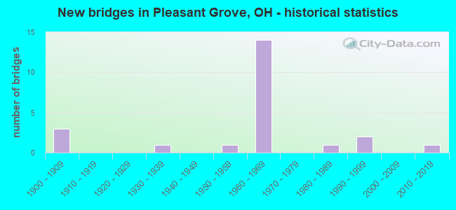
- New bridges - historical statistics
- 31900-1909
- 11930-1939
- 11950-1959
- 141960-1969
- 11980-1989
- 21990-1999
- 12010-2019

- Reconstructed bridges - Historical Statistics
- 11920-1929
- 01930-1939
- 01940-1949
- 01950-1959
- 01960-1969
- 01970-1979
- 01980-1989
- 01990-1999
- 12000-2009
- 32010-2019
- 12020-2022


- Bridge Condition - Deck
- 25.0%Excellent
- 6.3%Very good
- 62.5%Good
- 6.3%Satisfactory

- Bridge Condition - Superstructure
- 18.8%Excellent
- 12.5%Very good
- 62.5%Good
- 6.3%Satisfactory

- Bridge Condition - Substructure
- 25.0%Excellent
- 18.8%Very good
- 31.3%Good
- 18.8%Satisfactory
- 6.3%Fair

- Bridge Condition - Channel
- 30.0%Excellent
- 20.0%Very good
- 40.0%Good
- 10.0%Satisfactory
Find on map >> Show street view
Structure Number: 6000517, Location: 1.2 M W OF JCT 93 (Lat: 39.942439, Lng: -81.981631), Route carried "on" structure: US 22, Year Built: 1900, Year Reconstructed: 1932, Status: Open, Structure Length: 0.64m (2.10ft), Average Daily Traffic: 7,970 (year 2015), Truck Traffic: 5%, Average Future Daily Traffic: 11,062 (year 2035), Design Load: H 15, Features Intersected: OVER BR MILL RUN
Minimum Vertical Clearance: 30+ m (98+ ft), Kilometerpoint: 21.469, Lanes on structure: 2, Owner: State Highway Agency, Approaching Roadway Width: 14.0m (45.9ft), Material/Design: Masonry, Design/Construction: Culvert, Number Of Spans In Main Unit: 1, Length of Maximum Span: 6.1m (20.0ft)
Condition: Channel: Good, Culverts: Fair, Operating Rating: 40.8 metric tons, Method Used To Determine Operating Rating: Field evaluation and documented engineering judgment, Inventory Rating: 32.7 metric tons, Method Used To Determine Inventory Rating: Field evaluation and documented engineering judgment, Structural Evaluation: Somewhat better than minimum adequacy, Waterway Adequacy: Equal to present minimum criteria, Approach Roadway Alignment: Better than present minimum criteria, Designated Inspection Frequency: Every 12 months, Inspection Date: September 2021
Find on map >> Show street view
Structure Number: 6000631, Location: .7 M E OF JCT SR 797 (Lat: 39.968361, Lng: -81.885581), Route carried "on" structure: US 22, Year Built: 1938, Year Reconstructed: 2020, Status: Open, Structure Length: 1.56m (5.12ft), Average Daily Traffic: 6,600 (year 2020), Truck Traffic: 3%, Average Future Daily Traffic: 7,300 (year 2040), Design Load: HL 93, Features Intersected: OVER LITTLE SALT CREEK
Minimum Vertical Clearance: 30+ m (98+ ft), Kilometerpoint: 30.304, Lanes on structure: 2, Owner: State Highway Agency, Approaching Roadway Width: 10.4m (34.1ft), Skew: 3 degrees, Material/Design: Steel, Design/Construction: Stringer/Multi-beam, Number Of Spans In Main Unit: 1, Length of Maximum Span: 14.4m (47.2ft), Curb-To-Curb Width: 10.4m (34.1ft), Out-to-Out Width: 10.7m (35.1ft)
Condition: Deck: Excellent, Superstructure: Excellent, Substructure: Excellent, Channel: Excellent, Operating Rating: 71.3 metric tons, Method Used To Determine Operating Rating: Load and Resistance Factor Rating (LRFR) rating reported by rating factor(RF) method using HL-93 loadings, Inventory Rating: 55.1 metric tons, Method Used To Determine Inventory Rating: Load and Resistance Factor Rating (LRFR) rating reported by rating factor(RF) method using HL-93 loadings, Structural Evaluation: Superior to present desirable criteria, Deck Geometry: Meets minimum limits, Waterway Adequacy: Superior to present desirable criteria, Approach Roadway Alignment: Equal to present desirable criteria, Length Of Structure Improvement: 1.55m (5.09ft), Designated Inspection Frequency: Every 12 months, Inspection Date: September 2021, Deck Structure Type: Concrete Cast-file-Place, Wearing Surface/Protective System: Wearing Surface: Monolithic Concrete, Deck Protection: Galvanized Reinforcing
Find on map >> Show street view
Structure Number: 600306, Location: SR 93 OVER I-70 (Lat: 39.949350, Lng: -81.960481), Route carried "on" structure: State highway 93, Year Built: 1963, Status: Open, Structure Length: 8.63m (28.31ft), Average Daily Traffic: 10,128 (year 2015), Truck Traffic: 12%, Average Future Daily Traffic: 14,058 (year 2035), Design Load: H 20, Features Intersected: SR93 OVER I-70
Minimum Vertical Clearance: 30+ m (98+ ft), Kilometerpoint: 20.680, Lanes on structure: 2, Lanes under structure: 4, Owner: State Highway Agency, Approaching Roadway Width: 13.4m (44.0ft), Material/Design: Steel continuous, Design/Construction: Stringer/Multi-beam, Number Of Spans In Main Unit: 4, Length of Maximum Span: 25.3m (83.0ft), Curb-To-Curb Width: 10.2m (33.5ft), Out-to-Out Width: 11.2m (36.7ft)
Condition: Deck: Good, Superstructure: Good, Substructure: Very good, Operating Rating: 35.6 metric tons, Method Used To Determine Operating Rating: Load and Resistance Factor Rating (LRFR) rating reported by rating factor(RF) method using HL-93 loadings, Inventory Rating: 29.2 metric tons, Method Used To Determine Inventory Rating: Load and Resistance Factor Rating (LRFR) rating reported by rating factor(RF) method using HL-93 loadings, Structural Evaluation: Better than present minimum criteria, Deck Geometry: Meets minimum limits, Underclear: Better than present minimum criteria, Approach Roadway Alignment: Equal to present desirable criteria, Designated Inspection Frequency: Every 24 months, Inspection Date: April 2021, Deck Structure Type: Concrete Cast-file-Place, Wearing Surface/Protective System: Wearing Surface: Integral Concrete
Find on map >> Show street view
Structure Number: 6003095, Location: 1.7 M E OF JCT SR 93 (Lat: 39.958911, Lng: -81.931069), Route carried "on" structure: Interstate 70, Year Built: 1963, Status: Open, Structure Length: 3.44m (11.29ft), Average Daily Traffic: 21,768 (year 2015), Truck Traffic: 28%, Average Future Daily Traffic: 30,214 (year 2035), Design Load: HS 20, Features Intersected: IR 70 OVR C191 JACKSON R
Minimum Vertical Clearance: 30+ m (98+ ft), Kilometerpoint: 25.878, Lanes on structure: 2, Lanes under structure: 2, Base Highway Network: Yes (, Subroute: 1), Owner: State Highway Agency, Approaching Roadway Width: 14.9m (48.9ft), Skew: 2 degrees, Material/Design: Steel continuous, Design/Construction: Stringer/Multi-beam, Number Of Spans In Main Unit: 3, Length of Maximum Span: 13.1m (43.0ft), Curb-To-Curb Width: 12.5m (41.0ft), Out-to-Out Width: 13.5m (44.3ft)
Condition: Deck: Satisfactory, Superstructure: Good, Substructure: Good, Operating Rating: 55.1 metric tons, Method Used To Determine Operating Rating: Load and Resistance Factor Rating (LRFR) rating reported by rating factor(RF) method using HL-93 loadings, Inventory Rating: 35.6 metric tons, Method Used To Determine Inventory Rating: Load and Resistance Factor Rating (LRFR) rating reported by rating factor(RF) method using HL-93 loadings, Structural Evaluation: Better than present minimum criteria, Deck Geometry: Better than present minimum criteria, Underclear: Meets minimum limits, Approach Roadway Alignment: Equal to present desirable criteria, Designated Inspection Frequency: Every 12 months, Inspection Date: April 2021, Deck Structure Type: Concrete Cast-file-Place, Wearing Surface/Protective System: Wearing Surface: Integral Concrete
Find on map >> Show street view
Structure Number: 6003125, Location: 1.7 M E OF JCT SR 93 (Lat: 39.958581, Lng: -81.931231), Route carried "on" structure: Interstate 70, Year Built: 1963, Status: Open, Structure Length: 4.45m (14.60ft), Average Daily Traffic: 21,768 (year 2015), Truck Traffic: 28%, Average Future Daily Traffic: 30,214 (year 2035), Design Load: HS 20+Mod, Features Intersected: IR 70 OVR C191 JACKSON R
Minimum Vertical Clearance: 30+ m (98+ ft), Kilometerpoint: 25.878, Lanes on structure: 2, Lanes under structure: 2, Base Highway Network: Yes (, Subroute: 1), Owner: State Highway Agency, Approaching Roadway Width: 14.9m (48.9ft), Skew: 2 degrees, Material/Design: Steel continuous, Design/Construction: Stringer/Multi-beam, Number Of Spans In Main Unit: 3, Length of Maximum Span: 16.8m (55.1ft), Curb-To-Curb Width: 12.5m (41.0ft), Out-to-Out Width: 13.5m (44.3ft)
Condition: Deck: Good, Superstructure: Good, Substructure: Satisfactory, Operating Rating: 55.1 metric tons, Method Used To Determine Operating Rating: Load Factor (LF) rating reported by rating factor (RF) method using MS18 loading, Inventory Rating: 35.6 metric tons, Method Used To Determine Inventory Rating: Load Factor (LF) rating reported by rating factor (RF) method using MS18 loading, Structural Evaluation: Equal to present minimum criteria, Deck Geometry: Better than present minimum criteria, Underclear: Meets minimum limits, Approach Roadway Alignment: Equal to present desirable criteria, Designated Inspection Frequency: Every 12 months, Inspection Date: April 2021, Deck Structure Type: Concrete Cast-file-Place, Wearing Surface/Protective System: Wearing Surface: Integral Concrete
Find on map >> Show street view
Structure Number: 6003184, Location: AT JCT OF CR 52 (Lat: 39.967169, Lng: -81.899500), Route carried "on" structure: County highway C0052, Year Built: 1963, Status: Open, Structure Length: 9.75m (31.99ft), Average Daily Traffic: 391 (year 2015), Truck Traffic: 5%, Average Future Daily Traffic: 50,033 (year 2035), Design Load: H 15, Features Intersected: C52 SONORA RD OVER I-70, Facility Carried by Structure: CR 52
Minimum Vertical Clearance: 30+ m (98+ ft), Kilometerpoint: 0.220, Lanes on structure: 2, Lanes under structure: 4, Owner: State Highway Agency, Approaching Roadway Width: 9.8m (32.2ft), Skew: 3 degrees, Material/Design: Steel continuous, Design/Construction: Stringer/Multi-beam, Number Of Spans In Main Unit: 4, Length of Maximum Span: 28.7m (94.2ft), Curb or Sidewalk Widths: Left: 0.6m (2.0ft), Right: 0.6m (2.0ft), Curb-To-Curb Width: 8.5m (27.9ft), Out-to-Out Width: 10.6m (34.8ft)
Condition: Deck: Good, Superstructure: Good, Substructure: Satisfactory, Operating Rating: 32.4 metric tons, Method Used To Determine Operating Rating: Load and Resistance Factor Rating (LRFR) rating reported by rating factor(RF) method using HL-93 loadings, Inventory Rating: 22.7 metric tons, Method Used To Determine Inventory Rating: Load and Resistance Factor Rating (LRFR) rating reported by rating factor(RF) method using HL-93 loadings, Structural Evaluation: Equal to present minimum criteria, Deck Geometry: Equal to present minimum criteria, Underclear: Somewhat better than minimum adequacy, Approach Roadway Alignment: Equal to present desirable criteria, Designated Inspection Frequency: Every 12 months, Inspection Date: April 2021, Deck Structure Type: Concrete Cast-file-Place, Wearing Surface/Protective System: Wearing Surface: Integral Concrete
Find on map >> Show street view
Structure Number: 6003214, Location: .3 M E OF JCT SR 797 (Lat: 39.969189, Lng: -81.888950), Route carried "on" structure: Interstate 70, Year Built: 1963, Status: Open, Structure Length: 4.24m (13.91ft), Average Daily Traffic: 20,026 (year 2015), Truck Traffic: 29%, Average Future Daily Traffic: 27,796 (year 2035), Design Load: HS 20+Mod, Features Intersected: IR 70 OVR LITTLE SALTCRK
Minimum Vertical Clearance: 30+ m (98+ ft), Kilometerpoint: 29.692, Lanes on structure: 2, Base Highway Network: Yes (, Subroute: 1), Owner: State Highway Agency, Approaching Roadway Width: 14.9m (48.9ft), Skew: 1 degrees, Material/Design: Steel continuous, Design/Construction: Stringer/Multi-beam, Number Of Spans In Main Unit: 3, Length of Maximum Span: 16.2m (53.1ft), Curb-To-Curb Width: 12.5m (41.0ft), Out-to-Out Width: 13.5m (44.3ft)
Condition: Deck: Good, Superstructure: Good, Substructure: Good, Channel: Very good, Operating Rating: 58.3 metric tons, Method Used To Determine Operating Rating: Load Factor (LF) rating reported by rating factor (RF) method using MS18 loading, Inventory Rating: 35.6 metric tons, Method Used To Determine Inventory Rating: Load Factor (LF) rating reported by rating factor (RF) method using MS18 loading, Structural Evaluation: Better than present minimum criteria, Deck Geometry: Better than present minimum criteria, Waterway Adequacy: Equal to present desirable criteria, Approach Roadway Alignment: Equal to present desirable criteria, Designated Inspection Frequency: Every 24 months, Inspection Date: April 2021, Deck Structure Type: Concrete Cast-file-Place, Wearing Surface/Protective System: Wearing Surface: Integral Concrete
Find on map >> Show street view
Structure Number: 6003249, Location: .3 M E OF JCT SR 797 (Lat: 39.968911, Lng: -81.888781), Route carried "on" structure: Interstate 70, Year Built: 1963, Status: Open, Structure Length: 4.24m (13.91ft), Average Daily Traffic: 20,026 (year 2015), Truck Traffic: 29%, Average Future Daily Traffic: 27,796 (year 2035), Design Load: HS 20+Mod, Features Intersected: IR 70 OVR LITTLE SALTCRK
Minimum Vertical Clearance: 30+ m (98+ ft), Kilometerpoint: 29.692, Lanes on structure: 2, Base Highway Network: Yes (, Subroute: 1), Owner: State Highway Agency, Approaching Roadway Width: 14.9m (48.9ft), Skew: 1 degrees, Material/Design: Steel continuous, Design/Construction: Stringer/Multi-beam, Number Of Spans In Main Unit: 3, Length of Maximum Span: 16.2m (53.1ft), Curb-To-Curb Width: 12.5m (41.0ft), Out-to-Out Width: 13.5m (44.3ft)
Condition: Deck: Good, Superstructure: Satisfactory, Substructure: Good, Channel: Very good, Operating Rating: 58.3 metric tons, Method Used To Determine Operating Rating: Load Factor (LF) rating reported by rating factor (RF) method using MS18 loading, Inventory Rating: 35.6 metric tons, Method Used To Determine Inventory Rating: Load Factor (LF) rating reported by rating factor (RF) method using MS18 loading, Structural Evaluation: Equal to present minimum criteria, Deck Geometry: Better than present minimum criteria, Waterway Adequacy: Equal to present desirable criteria, Approach Roadway Alignment: Equal to present desirable criteria, Designated Inspection Frequency: Every 12 months, Inspection Date: April 2021, Deck Structure Type: Concrete Cast-file-Place, Wearing Surface/Protective System: Wearing Surface: Integral Concrete
Find on map >> Show street view
Structure Number: 6003273, Location: .9 M E OF JCT SR 797 (Lat: 39.969600, Lng: -81.884000), Route carried "on" structure: Interstate 70, Year Built: 1964, Status: Open, Structure Length: 3.23m (10.60ft), Average Daily Traffic: 20,026 (year 2015), Truck Traffic: 29%, Average Future Daily Traffic: 27,796 (year 2035), Design Load: HS 20, Features Intersected: IR 70 OVR C67 BALD HIL R
Minimum Vertical Clearance: 30+ m (98+ ft), Kilometerpoint: 30.095, Lanes on structure: 2, Lanes under structure: 2, Base Highway Network: Yes (, Subroute: 1), Owner: State Highway Agency, Approaching Roadway Width: 14.9m (48.9ft), Skew: 1 degrees, Material/Design: Concrete continuous, Design/Construction: Slab, Number Of Spans In Main Unit: 3, Length of Maximum Span: 12.2m (40.0ft), Curb-To-Curb Width: 12.5m (41.0ft), Out-to-Out Width: 13.5m (44.3ft)
Condition: Deck: Good, Superstructure: Good, Substructure: Satisfactory, Operating Rating: 55.1 metric tons, Method Used To Determine Operating Rating: Load Factor (LF) rating reported by rating factor (RF) method using MS18 loading, Inventory Rating: 32.4 metric tons, Method Used To Determine Inventory Rating: Load Factor (LF) rating reported by rating factor (RF) method using MS18 loading, Structural Evaluation: Equal to present minimum criteria, Deck Geometry: Better than present minimum criteria, Underclear: Meets minimum limits, Approach Roadway Alignment: Equal to present desirable criteria, Designated Inspection Frequency: Every 12 months, Inspection Date: April 2021, Deck Structure Type: Concrete Cast-file-Place, Wearing Surface/Protective System: Wearing Surface: Bituminous
Find on map >> Show street view
Structure Number: 6003303, Location: .9 M E OF JCT SR 797 (Lat: 39.969311, Lng: -81.884150), Route carried "on" structure: Interstate 70, Year Built: 1964, Status: Open, Structure Length: 4.02m (13.19ft), Average Daily Traffic: 20,026 (year 2015), Truck Traffic: 29%, Average Future Daily Traffic: 27,796 (year 2035), Design Load: HS 20+Mod, Features Intersected: IR 70 OVR C67 BALD HIL R
Minimum Vertical Clearance: 30+ m (98+ ft), Kilometerpoint: 30.095, Lanes on structure: 2, Lanes under structure: 2, Base Highway Network: Yes (, Subroute: 1), Owner: State Highway Agency, Approaching Roadway Width: 14.9m (48.9ft), Skew: 1 degrees, Material/Design: Concrete continuous, Design/Construction: Slab, Number Of Spans In Main Unit: 3, Length of Maximum Span: 15.2m (49.9ft), Curb-To-Curb Width: 12.5m (41.0ft), Out-to-Out Width: 13.5m (44.3ft)
Condition: Deck: Good, Superstructure: Good, Substructure: Fair, Operating Rating: 64.8 metric tons, Method Used To Determine Operating Rating: Load Factor (LF) rating reported by rating factor (RF) method using MS18 loading, Inventory Rating: 38.9 metric tons, Method Used To Determine Inventory Rating: Load Factor (LF) rating reported by rating factor (RF) method using MS18 loading, Structural Evaluation: Somewhat better than minimum adequacy, Deck Geometry: Better than present minimum criteria, Underclear: Somewhat better than minimum adequacy, Approach Roadway Alignment: Equal to present desirable criteria, Designated Inspection Frequency: Every 12 months, Inspection Date: April 2021, Deck Structure Type: Concrete Cast-file-Place, Wearing Surface/Protective System: Wearing Surface: Bituminous
Find on map >> Show street view
Structure Number: 6004148, Location: 2.4 MI N OF I-70 (Lat: 39.977761, Lng: -81.942369), Route carried "on" structure: State highway 93, Year Built: 1957, Year Reconstructed: 2019, Status: Open, Structure Length: 5.30m (17.39ft), Average Daily Traffic: 2,600 (year 2019), Truck Traffic: 5%, Average Future Daily Traffic: 3,500 (year 2039), Design Load: HS 20+Mod, Features Intersected: SR 93 OVER CSX RR
Minimum Vertical Clearance: 30+ m (98+ ft), Kilometerpoint: 24.446, Lanes on structure: 2, Owner: State Highway Agency, Approaching Roadway Width: 11.0m (36.1ft), Skew: 3 degrees, Material/Design: Steel continuous, Design/Construction: Stringer/Multi-beam, Number Of Spans In Main Unit: 3, Length of Maximum Span: 19.8m (65.0ft), Curb-To-Curb Width: 8.5m (27.9ft), Out-to-Out Width: 10.8m (35.4ft)
Condition: Deck: Excellent, Superstructure: Very good, Substructure: Excellent, Operating Rating: 94.0 metric tons, Method Used To Determine Operating Rating: Load Factor (LF) rating reported by rating factor (RF) method using MS18 loading, Inventory Rating: 55.1 metric tons, Method Used To Determine Inventory Rating: Load Factor (LF) rating reported by rating factor (RF) method using MS18 loading, Structural Evaluation: Equal to present desirable criteria, Deck Geometry: Meets minimum limits, Underclear: Superior to present desirable criteria, Approach Roadway Alignment: Better than present minimum criteria, Designated Inspection Frequency: Every 12 months, Inspection Date: November 2021, Deck Structure Type: Concrete Cast-file-Place, Wearing Surface/Protective System: Wearing Surface: Monolithic Concrete, Deck Protection: Epoxy Coated Reinforcing
Find on map >> Show street view
Structure Number: 600418, Location: 3.5 M N OF JCT I-70 (Lat: 39.987181, Lng: -81.932161), Route carried "on" structure: State highway 93, Year Built: 1992, Status: Open, Structure Length: 1.83m (6.00ft), Average Daily Traffic: 2,374 (year 2015), Truck Traffic: 5%, Average Future Daily Traffic: 3,295 (year 2035), Design Load: HS 20+Mod, Features Intersected: OVER LITTLE SALT CREEK
Minimum Vertical Clearance: 30+ m (98+ ft), Kilometerpoint: 25.991, Lanes on structure: 2, Owner: State Highway Agency, Approaching Roadway Width: 9.8m (32.2ft), Skew: 1 degrees, Material/Design: Prestressed concrete, Design/Construction: Box Beam or Girders - Multiple, Number Of Spans In Main Unit: 1, Length of Maximum Span: 16.8m (55.1ft), Curb-To-Curb Width: 9.8m (32.2ft), Out-to-Out Width: 9.8m (32.2ft)
Condition: Deck: Good, Superstructure: Good, Substructure: Very good, Channel: Satisfactory, Operating Rating: 42.1 metric tons, Method Used To Determine Operating Rating: Load Factor (LF) rating reported by rating factor (RF) method using MS18 loading, Inventory Rating: 32.4 metric tons, Method Used To Determine Inventory Rating: Load Factor (LF) rating reported by rating factor (RF) method using MS18 loading, Structural Evaluation: Better than present minimum criteria, Deck Geometry: Meets minimum limits, Waterway Adequacy: Equal to present desirable criteria, Approach Roadway Alignment: Equal to present minimum criteria, Designated Inspection Frequency: Every 24 months, Inspection Date: November 2021, Deck Structure Type: Concrete Cast-file-Place, Wearing Surface/Protective System: Wearing Surface: Bituminous, Membrane: Built-up
Find on map >> Show street view
Structure Number: 6047238, Location: 1.89 MI N OF US 40 (Lat: 39.980800, Lng: -81.923739), Route carried "on" structure: County highway C0191, Year Built: 1989, Year Reconstructed: 2019, Status: Open, Structure Length: 0.88m (2.89ft), Average Daily Traffic: 495 (year 2015), Truck Traffic: 7%, Average Future Daily Traffic: 687 (year 2035), Design Load: HL 93, Features Intersected: LITTLE SALT CREEK, Facility Carried by Structure: JACKSON RD
Minimum Vertical Clearance: 30+ m (98+ ft), Kilometerpoint: 3.042, Lanes on structure: 2, Owner: County Highway Agency, Approaching Roadway Width: 6.1m (20.0ft), Skew: 1 degrees, Material/Design: Concrete, Design/Construction: Tee Beam, Number Of Spans In Main Unit: 1, Length of Maximum Span: 8.0m (26.2ft), Curb-To-Curb Width: 7.3m (24.0ft), Out-to-Out Width: 7.3m (24.0ft)
Condition: Deck: Good, Superstructure: Good, Substructure: Excellent, Channel: Excellent, Operating Rating: 97.2 metric tons, Method Used To Determine Operating Rating: Load and Resistance Factor Rating (LRFR) rating reported by rating factor(RF) method using HL-93 loadings, Inventory Rating: 74.5 metric tons, Method Used To Determine Inventory Rating: Load and Resistance Factor Rating (LRFR) rating reported by rating factor(RF) method using HL-93 loadings, Structural Evaluation: Better than present minimum criteria, Deck Geometry: Meets minimum limits, Waterway Adequacy: Better than present minimum criteria, Approach Roadway Alignment: Equal to present desirable criteria, Designated Inspection Frequency: Every 12 months, Inspection Date: October 2021, Deck Structure Type: Concrete Cast-file-Place, Wearing Surface/Protective System: Wearing Surface: Bituminous, Membrane: Other, Deck Protection: Epoxy Coated Reinforcing
Find on map >> Show street view
Structure Number: 6048218, Location: 0.59 MI N.OF IR70 (Lat: 39.975861, Lng: -81.906000), Route carried "on" structure: County highway C0052, Year Built: 1995, Status: Open, Structure Length: 1.04m (3.41ft), Average Daily Traffic: 404 (year 2015), Truck Traffic: 5%, Average Future Daily Traffic: 561 (year 2035), Design Load: HS 20, Features Intersected: LITTLE SALT CREEK, Facility Carried by Structure: SONORA RD
Minimum Vertical Clearance: 30+ m (98+ ft), Kilometerpoint: 0.950, Lanes on structure: 2, Owner: County Highway Agency, Approaching Roadway Width: 8.5m (27.9ft), Skew: 1 degrees, Material/Design: Steel, Design/Construction: Stringer/Multi-beam, Number Of Spans In Main Unit: 1, Length of Maximum Span: 9.8m (32.2ft), Curb-To-Curb Width: 9.8m (32.2ft), Out-to-Out Width: 9.8m (32.2ft)
Condition: Deck: Very good, Superstructure: Good, Substructure: Very good, Channel: Good, Operating Rating: 64.8 metric tons, Method Used To Determine Operating Rating: Load Factor (LF) rating reported by rating factor (RF) method using MS18 loading, Inventory Rating: 38.9 metric tons, Method Used To Determine Inventory Rating: Load Factor (LF) rating reported by rating factor (RF) method using MS18 loading, Structural Evaluation: Better than present minimum criteria, Deck Geometry: Equal to present minimum criteria, Waterway Adequacy: Better than present minimum criteria, Approach Roadway Alignment: Equal to present desirable criteria, Designated Inspection Frequency: Every 24 months, Inspection Date: October 2020, Deck Structure Type: Corrugated Steel, Wearing Surface/Protective System: Wearing Surface: Bituminous
Find on map >> Show street view
Structure Number: 6048374, Location: 0.75 Mi EAST of CR 52 (Lat: 39.974989, Lng: -81.892811), Route carried "on" structure: County highway T0108, Year Built: 2014, Status: Open, Structure Length: 1.34m (4.40ft), Average Daily Traffic: 455 (year 2015), Truck Traffic: 1%, Average Future Daily Traffic: 632 (year 2035), Design Load: HL 93, Features Intersected: LITTLE SALT CREEK, Facility Carried by Structure: BOGGS ROAD
Minimum Vertical Clearance: 30+ m (98+ ft), Kilometerpoint: 1.223, Lanes on structure: 2, Owner: County Highway Agency, Approaching Roadway Width: 6.1m (20.0ft), Material/Design: Steel, Design/Construction: Stringer/Multi-beam, Number Of Spans In Main Unit: 1, Length of Maximum Span: 12.8m (42.0ft), Curb-To-Curb Width: 7.3m (24.0ft), Out-to-Out Width: 7.3m (24.0ft)
Condition: Deck: Excellent, Superstructure: Excellent, Substructure: Excellent, Channel: Excellent, Operating Rating: 94.0 metric tons, Method Used To Determine Operating Rating: Load and Resistance Factor Rating (LRFR) rating reported by rating factor(RF) method using HL-93 loadings, Inventory Rating: 71.3 metric tons, Method Used To Determine Inventory Rating: Load and Resistance Factor Rating (LRFR) rating reported by rating factor(RF) method using HL-93 loadings, Structural Evaluation: Superior to present desirable criteria, Deck Geometry: Meets minimum limits, Waterway Adequacy: Better than present minimum criteria, Approach Roadway Alignment: Equal to present desirable criteria, Designated Inspection Frequency: Every 24 months, Inspection Date: October 2020, Total Project Cost: $127,500,000, Deck Structure Type: Concrete Cast-file-Place, Wearing Surface/Protective System: Wearing Surface: Monolithic Concrete, Deck Protection: Epoxy Coated Reinforcing
Find on map >> Show street view
Structure Number: 605411, Location: 0.84 MI E OF MILLERS LANE (Lat: 39.931469, Lng: -81.902581), Route carried "on" structure: County highway C0005, Year Built: 1900, Year Reconstructed: 2007, Status: Open, Structure Length: 1.71m (5.61ft), Average Daily Traffic: 1,101 (year 2015), Truck Traffic: 7%, Average Future Daily Traffic: 1,528 (year 2035), Design Load: H 10, Features Intersected: BOGGS CREEK, Facility Carried by Structure: CLAY PIKE
Minimum Vertical Clearance: 30+ m (98+ ft), Kilometerpoint: 2.591, Lanes on structure: 2, Owner: County Highway Agency, Approaching Roadway Width: 6.4m (21.0ft), Material/Design: Steel, Design/Construction: Stringer/Multi-beam, Number Of Spans In Main Unit: 1, Length of Maximum Span: 16.2m (53.1ft), Curb-To-Curb Width: 6.1m (20.0ft), Out-to-Out Width: 7.3m (24.0ft)
Condition: Deck: Good, Superstructure: Very good, Substructure: Good, Channel: Good, Operating Rating: 48.6 metric tons, Method Used To Determine Operating Rating: Load Factor (LF) rating reported by rating factor (RF) method using MS18 loading, Inventory Rating: 29.2 metric tons, Method Used To Determine Inventory Rating: Load Factor (LF) rating reported by rating factor (RF) method using MS18 loading, Structural Evaluation: Better than present minimum criteria, Deck Geometry: High priority of replacement, Waterway Adequacy: Better than present minimum criteria, Approach Roadway Alignment: Meets minimum limits, Designated Inspection Frequency: Every 24 months, Inspection Date: October 2020, Deck Structure Type: Concrete Cast-file-Place, Wearing Surface/Protective System: Wearing Surface: Monolithic Concrete, Membrane: Epoxy, Deck Protection: Epoxy Coated Reinforcing
Find on map >> Show street view
Structure Number: 605425, Location: 0.06 MI N OF SR 146 (Lat: 39.926511, Lng: -81.938819), Route carried "on" structure: County highway T0192, Year Built: 1900, Year Reconstructed: 2018, Status: Open, Structure Length: 0.70m (2.30ft), Average Daily Traffic: 324 (year 2015), Truck Traffic: 7%, Average Future Daily Traffic: 450 (year 2035), Design Load: HS 20, Features Intersected: BOGGS CREEK TRIBUTARY, Facility Carried by Structure: OSBORN ROAD
Minimum Vertical Clearance: 30+ m (98+ ft), Kilometerpoint: 0.097, Lanes on structure: 1, Owner: County Highway Agency, Approaching Roadway Width: 5.8m (19.0ft), Skew: 3 degrees, Material/Design: Steel, Design/Construction: Stringer/Multi-beam, Number Of Spans In Main Unit: 1, Length of Maximum Span: 6.7m (22.0ft), Curb-To-Curb Width: 4.9m (16.1ft), Out-to-Out Width: 4.9m (16.1ft)
Condition: Deck: Excellent, Superstructure: Excellent, Substructure: Good, Channel: Good, Operating Rating: 97.2 metric tons, Method Used To Determine Operating Rating: Allowable Stress (AS) rating reported by rating factor (RF) method using MS18 loading, Inventory Rating: 74.5 metric tons, Method Used To Determine Inventory Rating: Allowable Stress (AS) rating reported by rating factor (RF) method using MS18 loading, Structural Evaluation: Better than present minimum criteria, Deck Geometry: High priority of replacement, Waterway Adequacy: Better than present minimum criteria, Approach Roadway Alignment: Better than present minimum criteria, Designated Inspection Frequency: Every 24 months, Inspection Date: October 2020, Deck Structure Type: Wood or Timber, Wearing Surface/Protective System: Wearing Surface: Bituminous
Find on map >> Show street view
Structure Number: 600306, Location: SR 93 OVER I-70 (Lat: 39.949350, Lng: -81.960481), Route carried "under" structure: Interstate 70, Year Built: 1963, Structure Length: 0. m, Average Daily Traffic: 40,197 (year 2015), Truck Traffic: 27%, Features Intersected: I-70 UNDER SR 93, Facility Carried by Structure: SR 93
Minimum Vertical Clearance: 5.05m (16.57ft), Kilometerpoint: 23.150, Lanes on structure: 2, Lanes under structure: 4, Material/Design: Steel continuous, Design/Construction: Stringer/Multi-beam, Length of Maximum Span: 25.3m (83.0ft)
Find on map >> Show street view
Structure Number: 6003095, Location: 1.7 M E OF JCT SR 93 (Lat: 39.958911, Lng: -81.931069), Route carried "under" structure: County highway 191, Year Built: 1963, Structure Length: 0. m, Average Daily Traffic: 536 (year 2015), Truck Traffic: 5%, Features Intersected: C191 JACKSON RD UND I70, Facility Carried by Structure: WEST BOUND I-70
Minimum Vertical Clearance: 4.32m (14.17ft), Kilometerpoint: 0.385, Lanes on structure: 2, Lanes under structure: 2, Material/Design: Steel continuous, Design/Construction: Stringer/Multi-beam, Length of Maximum Span: 13.1m (43.0ft)
Find on map >> Show street view
Structure Number: 6003125, Location: 1.7 M E OF JCT SR 93 (Lat: 39.958581, Lng: -81.931231), Route carried "under" structure: County highway 191, Year Built: 1963, Structure Length: 0. m, Average Daily Traffic: 536 (year 2015), Truck Traffic: 5%, Features Intersected: C191 JACKSON RD UND I70, Facility Carried by Structure: EAST BOUND I-70
Minimum Vertical Clearance: 6.22m (20.41ft), Kilometerpoint: 0.385, Lanes on structure: 2, Lanes under structure: 2, Material/Design: Steel continuous, Design/Construction: Stringer/Multi-beam, Length of Maximum Span: 16.8m (55.1ft)
Find on map >> Show street view
Structure Number: 6003184, Location: AT JCT OF CR 52 (Lat: 39.967169, Lng: -81.899500), Route carried "under" structure: Interstate 70, Year Built: 1963, Structure Length: 0. m, Average Daily Traffic: 36,047 (year 2015), Truck Traffic: 28%, Features Intersected: IR 70 UNDR C52 SANORA RD, Facility Carried by Structure: CR 52
Minimum Vertical Clearance: 5.16m (16.93ft), Kilometerpoint: 28.743, Lanes on structure: 2, Lanes under structure: 4, Material/Design: Steel continuous, Design/Construction: Stringer/Multi-beam, Length of Maximum Span: 28.7m (94.2ft)
Find on map >> Show street view
Structure Number: 6003273, Location: .9 M E OF JCT SR 797 (Lat: 39.969600, Lng: -81.884000), Route carried "under" structure: County highway 67, Year Built: 1964, Structure Length: 0. m, Average Daily Traffic: 223 (year 2015), Truck Traffic: 5%, Features Intersected: C67 BALD HILL RD UND I70, Facility Carried by Structure: WEST BOUND I-70
Minimum Vertical Clearance: 4.27m (14.01ft), Kilometerpoint: 0.113, Lanes on structure: 2, Lanes under structure: 2, Material/Design: Concrete continuous, Design/Construction: Slab, Length of Maximum Span: 12.2m (40.0ft)
Find on map >> Show street view
Structure Number: 6003303, Location: .9 M E OF JCT SR 797 (Lat: 39.969311, Lng: -81.884150), Route carried "under" structure: County highway 67, Year Built: 1964, Structure Length: 0. m, Average Daily Traffic: 223 (year 2015), Truck Traffic: 5%, Features Intersected: C67 BALD HILL RD UND I7, Facility Carried by Structure: EAST BOUND I-70
Minimum Vertical Clearance: 6.60m (21.65ft), Kilometerpoint: 0.113, Lanes on structure: 2, Lanes under structure: 2, Material/Design: Concrete continuous, Design/Construction: Slab, Length of Maximum Span: 15.2m (49.9ft)