Bridge Statistics for Pleasant Grove, Maryland (MD)
Condition, Traffic, Stress, Structural Evaluation, Project Costs
- National Bridge Inventory (NBI) Statistics
- 25Number of bridges
- 381ft / 116mTotal length
- $90,000Total costs
- 167,628Total average daily traffic
- 12,410Total average daily truck traffic
- National Bridge Inventory (NBI) Registered Bridges for Pleasant Grove
- No street view available for this location
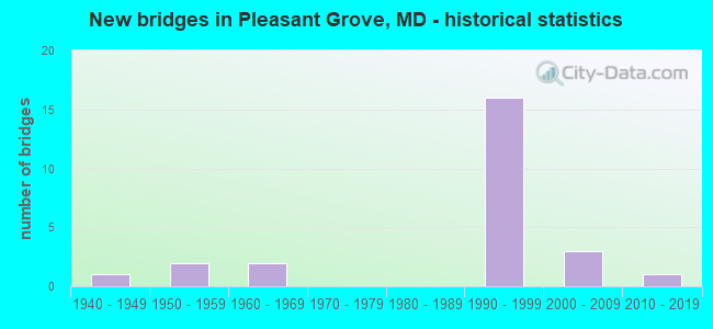
- New bridges - historical statistics
- 11940-1949
- 21950-1959
- 21960-1969
- 161990-1999
- 32000-2009
- 12010-2019

- Reconstructed bridges - Historical Statistics
- 11960-1969
- 11970-1979


- Bridge Condition - Deck
- 7.1%Very good
- 64.3%Good
- 21.4%Satisfactory
- 7.1%Fair

- Bridge Condition - Superstructure
- 7.1%Very good
- 64.3%Good
- 7.1%Satisfactory
- 14.3%Fair
- 7.1%Poor

- Bridge Condition - Substructure
- 7.1%Very good
- 71.4%Good
- 14.3%Satisfactory
- 7.1%Poor

- Bridge Condition - Channel
- 11.8%Very good
- 64.7%Good
- 17.6%Satisfactory
- 5.9%Fair

- Bridge Condition - Culverts
- 33.3%Good
- 33.3%Satisfactory
- 33.3%Fair
Find on map >> Show street view
Structure Number: 10000001005602, Location: 0.86 MILE SOUTH OF US 220 (Lat: 39.706164, Lng: -78.712775), Route carried "on" structure: State highway 807, Year Built: 2002, Status: Open, Structure Length: 0.72m (2.36ft), Average Daily Traffic: 5,092 (year 2009), Truck Traffic: 8%, Average Future Daily Traffic: 7,638 (year 2029), Design Load: HS 25 or greater, Features Intersected: PEA VINE RUN
Minimum Vertical Clearance: 30+ m (98+ ft), Kilometerpoint: 4.275, Lanes on structure: 2, Owner: State Highway Agency, Approaching Roadway Width: 9.1m (29.9ft), Skew: 3 degrees, Material/Design: Concrete, Design/Construction: Culvert, Number Of Spans In Main Unit: 2, Length of Maximum Span: 3.4m (11.2ft), Curb or Sidewalk Widths: Left: 0.4m (1.3ft), Right: 0.4m (1.3ft), Curb-To-Curb Width: 9.1m (29.9ft), Out-to-Out Width: 9.8m (32.2ft)
Condition: Channel: Good, Culverts: Good, Inventory Rating: 80.7 metric tons, Method Used To Determine Inventory Rating: Load Factor (LF), Structural Evaluation: Better than present minimum criteria, Deck Geometry: High priority of corrective action, Waterway Adequacy: Better than present minimum criteria, Approach Roadway Alignment: Equal to present desirable criteria, Designated Inspection Frequency: Every 24 months, Inspection Date: March 2021, Wearing Surface/Protective System: Wearing Surface: Bituminous, Deck Protection: Epoxy Coated Reinforcing
Find on map >> Show street view
Structure Number: 10000001008602, Location: 0.62 M E OF BR NO 0115400 (Lat: 39.678111, Lng: -78.682183), Route carried "on" structure: State highway 144, Year Built: 1960, Status: Open, Structure Length: 0.99m (3.25ft), Average Daily Traffic: 1,121 (year 2009), Truck Traffic: 8%, Average Future Daily Traffic: 1,339 (year 2026), Design Load: HS 20+Mod, Features Intersected: ELK LICK CREEK
Minimum Vertical Clearance: 30+ m (98+ ft), Kilometerpoint: 5.632, Lanes on structure: 5, Owner: State Highway Agency, Approaching Roadway Width: 20.7m (67.9ft), Skew: 24 degrees, Material/Design: Concrete, Design/Construction: Culvert, Length of Maximum Span: 4.9m (16.1ft)
Condition: Channel: Good, Culverts: Fair, Operating Rating: 83.9 metric tons, Method Used To Determine Operating Rating: Load Factor (LF), Inventory Rating: 50.3 metric tons, Method Used To Determine Inventory Rating: Load Factor (LF), Structural Evaluation: Somewhat better than minimum adequacy, Waterway Adequacy: Meets minimum limits, Approach Roadway Alignment: Equal to present minimum criteria, Designated Inspection Frequency: Every 24 months, Inspection Date: Febuary 2021
Find on map >> Show street view
Structure Number: 10000001014803, Location: 0.16 M E OF ROCKY GAP RD (Lat: 39.683989, Lng: -78.665883), Route carried "on" structure: ServiceState highway 144, Year Built: 1990, Status: Open, Structure Length: 0.87m (2.85ft), Average Daily Traffic: 1,161 (year 2006), Truck Traffic: 5%, Average Future Daily Traffic: 1,339 (year 2026), Design Load: HS 20, Features Intersected: ELK LICK RUN
Minimum Vertical Clearance: 30+ m (98+ ft), Kilometerpoint: 7.176, Lanes on structure: 2, Owner: State Highway Agency, Approaching Roadway Width: 10.4m (34.1ft), Material/Design: Steel, Design/Construction: Culvert, Length of Maximum Span: 4.0m (13.1ft)
Condition: Channel: Satisfactory, Culverts: Fair, Structural Evaluation: Somewhat better than minimum adequacy, Waterway Adequacy: Equal to present minimum criteria, Approach Roadway Alignment: Equal to present desirable criteria, Designated Inspection Frequency: Every 24 months, Inspection Date: December 2020
Find on map >> Show street view
Structure Number: 10000001015001, Location: 0.07 MILE NORTH OF MD 144 (Lat: 39.694100, Lng: -78.649683), Route carried "on" structure: ServiceState highway 948AD, Year Built: 1990, Status: Open, Structure Length: 8.53m (27.99ft), Average Daily Traffic: 1,314 (year 2009), Truck Traffic: 5%, Average Future Daily Traffic: 1,569 (year 2026), Design Load: HS 20, Features Intersected: IS 68
Minimum Vertical Clearance: 30+ m (98+ ft), Kilometerpoint: 0.113, Lanes on structure: 2, Lanes under structure: 5, Owner: State Highway Agency, Approaching Roadway Width: 10.4m (34.1ft), Skew: 2 degrees, Material/Design: Steel continuous, Design/Construction: Stringer/Multi-beam, Number Of Spans In Main Unit: 2, Length of Maximum Span: 41.8m (137.1ft), Curb-To-Curb Width: 10.4m (34.1ft), Out-to-Out Width: 11.3m (37.1ft)
Condition: Deck: Good, Superstructure: Good, Substructure: Good, Inventory Rating: 72.6 metric tons, Method Used To Determine Inventory Rating: Load Factor (LF), Structural Evaluation: Better than present minimum criteria, Deck Geometry: Equal to present minimum criteria, Underclear: Better than present minimum criteria, Approach Roadway Alignment: Equal to present desirable criteria, Designated Inspection Frequency: Every 24 months, Inspection Date: May 2021, Deck Structure Type: Concrete Cast-file-Place, Wearing Surface/Protective System: Wearing Surface: Monolithic Concrete, Deck Protection: Epoxy Coated Reinforcing
Find on map >> Show street view
Structure Number: 10000001015101, Location: 0.04 MILE NORTH OF MD 144 (Lat: 39.682819, Lng: -78.668639), Route carried "on" structure: State highway 948AE, Year Built: 1990, Status: Open, Structure Length: 8.08m (26.51ft), Average Daily Traffic: 99 (year 2006), Truck Traffic: 5%, Average Future Daily Traffic: 236 (year 2026), Design Load: HS 20, Features Intersected: IS 68, ELK LICK RUN
Minimum Vertical Clearance: 30+ m (98+ ft), Kilometerpoint: 4.119, Lanes on structure: 2, Lanes under structure: 5, Owner: State Highway Agency, Approaching Roadway Width: 8.5m (27.9ft), Skew: 2 degrees, Material/Design: Steel continuous, Design/Construction: Stringer/Multi-beam, Number Of Spans In Main Unit: 2, Length of Maximum Span: 48.8m (160.1ft), Curb-To-Curb Width: 8.6m (28.2ft), Out-to-Out Width: 9.6m (31.5ft)
Condition: Deck: Satisfactory, Superstructure: Good, Substructure: Good, Channel: Good, Inventory Rating: 65.3 metric tons, Method Used To Determine Inventory Rating: Load Factor (LF), Structural Evaluation: Better than present minimum criteria, Deck Geometry: Better than present minimum criteria, Underclear: Somewhat better than minimum adequacy, Approach Roadway Alignment: Equal to present desirable criteria, Designated Inspection Frequency: Every 24 months, Inspection Date: January 2021, Deck Structure Type: Concrete Cast-file-Place, Wearing Surface/Protective System: Wearing Surface: Monolithic Concrete, Deck Protection: Epoxy Coated Reinforcing
Find on map >> Show street view
Structure Number: 10000001015203, Location: 0.82 M E OF BR NO 0115400 (Lat: 39.679083, Lng: -78.681408), Route carried "on" structure: Interstate 68, Year Built: 1990, Status: Open, Structure Length: 1.00m (3.28ft), Average Daily Traffic: 18,670 (year 2006), Truck Traffic: 8%, Average Future Daily Traffic: 20,164 (year 2026), Design Load: HS 20, Features Intersected: ELK LICK RUN
Minimum Vertical Clearance: 30+ m (98+ ft), Kilometerpoint: 29.226, Lanes on structure: 4, Base Highway Network: Yes, Owner: State Highway Agency, Approaching Roadway Width: 31.1m (102.0ft), Skew: 3 degrees, Material/Design: Steel, Design/Construction: Culvert, Length of Maximum Span: 4.6m (15.1ft)
Condition: Channel: Good, Culverts: Satisfactory, Structural Evaluation: Equal to present minimum criteria, Waterway Adequacy: Equal to present desirable criteria, Approach Roadway Alignment: Equal to present desirable criteria, Designated Inspection Frequency: Every 24 months, Inspection Date: December 2020
Find on map >> Show street view
Structure Number: 10000001015303, Location: 0.184 MI W BR NO. 0115200 (Lat: 39.675328, Lng: -78.690622), Route carried "on" structure: Interstate 68, Year Built: 1990, Status: Open, Structure Length: 1.49m (4.89ft), Average Daily Traffic: 18,670 (year 2006), Truck Traffic: 8%, Average Future Daily Traffic: 20,164 (year 2026), Design Load: HS 20, Features Intersected: ELK LICK RUN
Minimum Vertical Clearance: 30+ m (98+ ft), Kilometerpoint: 28.936, Lanes on structure: 4, Base Highway Network: Yes, Owner: State Highway Agency, Approaching Roadway Width: 31.1m (102.0ft), Skew: 5 degrees, Material/Design: Steel, Design/Construction: Culvert, Length of Maximum Span: 6.7m (22.0ft)
Condition: Channel: Good, Culverts: Satisfactory, Structural Evaluation: Equal to present minimum criteria, Waterway Adequacy: Equal to present desirable criteria, Approach Roadway Alignment: Equal to present desirable criteria, Designated Inspection Frequency: Every 24 months, Inspection Date: December 2020
Find on map >> Show street view
Structure Number: 100000010154013, Location: 0.86 M E OF BR NO 0115500 (Lat: 39.673942, Lng: -78.692989), Route carried "on" structure: Interstate 68, Year Built: 1990, Status: Open, Structure Length: 26.21m (85.99ft), Average Daily Traffic: 21,600 (year 2009), Truck Traffic: 8%, Average Future Daily Traffic: 34,040 (year 2029), Design Load: HS 20, Features Intersected: MD 144, ELK LICK RUN
Minimum Vertical Clearance: 30+ m (98+ ft), Kilometerpoint: 26.907, Lanes on structure: 3, Lanes under structure: 4, Base Highway Network: Yes, Owner: State Highway Agency, Approaching Roadway Width: 14.6m (47.9ft), Material/Design: Steel continuous, Design/Construction: Stringer/Multi-beam, Number Of Spans In Main Unit: 4, Length of Maximum Span: 77.7m (254.9ft), Curb-To-Curb Width: 14.6m (47.9ft), Out-to-Out Width: 15.6m (51.2ft)
Condition: Deck: Good, Superstructure: Good, Substructure: Good, Channel: Very good, Operating Rating: 59.9 metric tons, Method Used To Determine Operating Rating: Load Factor (LF), Inventory Rating: 35.8 metric tons, Method Used To Determine Inventory Rating: Load Factor (LF), Structural Evaluation: Better than present minimum criteria, Deck Geometry: Meets minimum limits, Underclear: Superior to present desirable criteria, Waterway Adequacy: Superior to present desirable criteria, Approach Roadway Alignment: Equal to present desirable criteria, Designated Inspection Frequency: Every 24 months, Inspection Date: April 2021, Deck Structure Type: Concrete Cast-file-Place, Wearing Surface/Protective System: Wearing Surface: Monolithic Concrete, Deck Protection: Epoxy Coated Reinforcing
Find on map >> Show street view
Structure Number: 100000010154014, Location: 0.86 M E OF BR NO 0115500 (Lat: 39.675517, Lng: -78.690778), Route carried "on" structure: Interstate 68, Year Built: 1990, Status: Open, Structure Length: 26.21m (85.99ft), Average Daily Traffic: 21,600 (year 2009), Truck Traffic: 8%, Average Future Daily Traffic: 34,040 (year 2029), Design Load: HS 20, Features Intersected: MD 144, ELK LICK RUN
Minimum Vertical Clearance: 30+ m (98+ ft), Kilometerpoint: 27.015, Lanes on structure: 2, Lanes under structure: 4, Base Highway Network: Yes, Owner: State Highway Agency, Approaching Roadway Width: 11.0m (36.1ft), Material/Design: Steel continuous, Design/Construction: Stringer/Multi-beam, Number Of Spans In Main Unit: 4, Length of Maximum Span: 77.7m (254.9ft), Curb-To-Curb Width: 11.0m (36.1ft), Out-to-Out Width: 11.9m (39.0ft)
Condition: Deck: Good, Superstructure: Good, Substructure: Good, Channel: Very good, Operating Rating: 63.9 metric tons, Method Used To Determine Operating Rating: Load Factor (LF), Inventory Rating: 38.1 metric tons, Method Used To Determine Inventory Rating: Load Factor (LF), Structural Evaluation: Better than present minimum criteria, Deck Geometry: Somewhat better than minimum adequacy, Underclear: Superior to present desirable criteria, Approach Roadway Alignment: Equal to present desirable criteria, Designated Inspection Frequency: Every 24 months, Inspection Date: April 2021, Deck Structure Type: Concrete Cast-file-Place, Wearing Surface/Protective System: Wearing Surface: Monolithic Concrete, Deck Protection: Epoxy Coated Reinforcing
Find on map >> Show street view
Structure Number: 10000001015501, Location: AT IS 68 (Lat: 39.669614, Lng: -78.705708), Route carried "on" structure: State highway 948AF, Year Built: 1990, Status: Open, Structure Length: 6.19m (20.31ft), Average Daily Traffic: 221 (year 2006), Truck Traffic: 5%, Average Future Daily Traffic: 255 (year 2026), Design Load: HS 20, Features Intersected: IS 68
Minimum Vertical Clearance: 30+ m (98+ ft), Kilometerpoint: 1.207, Lanes on structure: 2, Lanes under structure: 5, Owner: State Highway Agency, Approaching Roadway Width: 8.5m (27.9ft), Skew: 1 degrees, Material/Design: Steel continuous, Design/Construction: Stringer/Multi-beam, Number Of Spans In Main Unit: 2, Length of Maximum Span: 33.5m (109.9ft), Curb-To-Curb Width: 8.5m (27.9ft), Out-to-Out Width: 9.5m (31.2ft)
Condition: Deck: Good, Superstructure: Good, Substructure: Good, Inventory Rating: 56.2 metric tons, Method Used To Determine Inventory Rating: Load Factor (LF), Structural Evaluation: Better than present minimum criteria, Deck Geometry: Equal to present minimum criteria, Underclear: Equal to present minimum criteria, Approach Roadway Alignment: Equal to present desirable criteria, Designated Inspection Frequency: Every 24 months, Inspection Date: July 2020, Deck Structure Type: Concrete Cast-file-Place, Wearing Surface/Protective System: Wearing Surface: Monolithic Concrete, Deck Protection: Epoxy Coated Reinforcing
Find on map >> Show street view
Structure Number: 10000001016901, Location: 0.71 MILE NORTH OF I-68 (Lat: 39.682969, Lng: -78.715133), Route carried "on" structure: US 220, Year Built: 1999, Status: Open, Structure Length: 6.68m (21.92ft), Average Daily Traffic: 3,841 (year 2009), Truck Traffic: 8%, Average Future Daily Traffic: 4,761 (year 2029), Design Load: HS 25 or greater, Features Intersected: EVITTS CREEK
Minimum Vertical Clearance: 30+ m (98+ ft), Kilometerpoint: 39.068, Lanes on structure: 2, Base Highway Network: Yes, Owner: State Highway Agency, Approaching Roadway Width: 14.9m (48.9ft), Skew: 2 degrees, Material/Design: Prestressed concrete continuous, Design/Construction: Stringer/Multi-beam, Number Of Spans In Main Unit: 2, Length of Maximum Span: 32.9m (107.9ft), Curb-To-Curb Width: 15.1m (49.5ft), Out-to-Out Width: 16.0m (52.5ft)
Condition: Deck: Good, Superstructure: Good, Substructure: Good, Channel: Good, Inventory Rating: 58.5 metric tons, Method Used To Determine Inventory Rating: Load Factor (LF), Structural Evaluation: Better than present minimum criteria, Deck Geometry: Superior to present desirable criteria, Waterway Adequacy: Superior to present desirable criteria, Approach Roadway Alignment: Equal to present desirable criteria, Designated Inspection Frequency: Every 24 months, Inspection Date: September 2020, Deck Structure Type: Concrete Cast-file-Place, Wearing Surface/Protective System: Wearing Surface: Integral Concrete, Deck Protection: Epoxy Coated Reinforcing
Find on map >> Show street view
Structure Number: 10000001017001, Location: 0.82 MILE NORTH OF I-68 (Lat: 39.685269, Lng: -78.714614), Route carried "on" structure: US 220, Year Built: 1999, Status: Open, Structure Length: 3.90m (12.80ft), Average Daily Traffic: 3,841 (year 2009), Truck Traffic: 20%, Average Future Daily Traffic: 4,761 (year 2029), Design Load: HS 25 or greater, Features Intersected: MASON ROAD
Minimum Vertical Clearance: 30+ m (98+ ft), Kilometerpoint: 39.324, Lanes on structure: 2, Lanes under structure: 2, Base Highway Network: Yes, Owner: State Highway Agency, Approaching Roadway Width: 14.9m (48.9ft), Skew: 4 degrees, Material/Design: Steel, Design/Construction: Stringer/Multi-beam, Number Of Spans In Main Unit: 1, Length of Maximum Span: 36.6m (120.1ft), Curb-To-Curb Width: 14.9m (48.9ft), Out-to-Out Width: 16.6m (54.5ft)
Condition: Deck: Good, Superstructure: Good, Substructure: Good, Inventory Rating: 76.2 metric tons, Method Used To Determine Inventory Rating: Load Factor (LF), Structural Evaluation: Better than present minimum criteria, Deck Geometry: Superior to present desirable criteria, Underclear: Meets minimum limits, Approach Roadway Alignment: Equal to present desirable criteria, Designated Inspection Frequency: Every 24 months, Inspection Date: October 2020, Deck Structure Type: Concrete Cast-file-Place, Wearing Surface/Protective System: Wearing Surface: Integral Concrete, Deck Protection: Epoxy Coated Reinforcing
Find on map >> Show street view
Structure Number: 10000001017101, Location: 1063 MILES NORTH OF IS 68 (Lat: 39.695319, Lng: -78.710994), Route carried "on" structure: US 220, Year Built: 1999, Status: Open, Structure Length: 14.54m (47.70ft), Average Daily Traffic: 3,841 (year 2009), Truck Traffic: 20%, Average Future Daily Traffic: 4,761 (year 2029), Design Load: HS 25 or greater, Features Intersected: PEA VINE RUN & BEALS MIL
Minimum Vertical Clearance: 30+ m (98+ ft), Kilometerpoint: 40.563, Lanes on structure: 2, Lanes under structure: 2, Base Highway Network: Yes, Owner: State Highway Agency, Approaching Roadway Width: 14.9m (48.9ft), Skew: 3 degrees, Material/Design: Steel continuous, Design/Construction: Stringer/Multi-beam, Number Of Spans In Main Unit: 3, Length of Maximum Span: 57.6m (189.0ft), Curb-To-Curb Width: 15.1m (49.5ft), Out-to-Out Width: 16.3m (53.5ft)
Condition: Deck: Good, Superstructure: Good, Substructure: Good, Channel: Good, Operating Rating: 83.9 metric tons, Method Used To Determine Operating Rating: Load Factor (LF), Inventory Rating: 50.3 metric tons, Method Used To Determine Inventory Rating: Load Factor (LF), Structural Evaluation: Better than present minimum criteria, Deck Geometry: Superior to present desirable criteria, Underclear: Superior to present desirable criteria, Waterway Adequacy: Superior to present desirable criteria, Approach Roadway Alignment: Equal to present desirable criteria, Designated Inspection Frequency: Every 24 months, Inspection Date: September 2020, Deck Structure Type: Concrete Cast-file-Place, Wearing Surface/Protective System: Wearing Surface: Integral Concrete, Deck Protection: Epoxy Coated Reinforcing
Find on map >> Show street view
Structure Number: 10000001017602, Location: 100 FEET SOUTH OF MD 144 (Lat: 39.675831, Lng: -78.694972), Route carried "on" structure: County highway , Year Built: 1966, Status: Open, Structure Length: 0.64m (2.10ft), Average Daily Traffic: 50 (year 2005), Average Future Daily Traffic: 60 (year 2025), Design Load: H 15, Features Intersected: ELK LICK RUN, Facility Carried by Structure: CEDAR KNOLL LANE
Minimum Vertical Clearance: 30+ m (98+ ft), Kilometerpoint: 0.031, Lanes on structure: 2, Owner: State Highway Agency, Approaching Roadway Width: 6.4m (21.0ft), Material/Design: Concrete, Design/Construction: Culvert, Number Of Spans In Main Unit: 2, Length of Maximum Span: 3.0m (9.8ft)
Condition: Channel: Good, Culverts: Good, Operating Rating: 77.1 metric tons, Method Used To Determine Operating Rating: Load Factor (LF), Inventory Rating: 46.3 metric tons, Method Used To Determine Inventory Rating: Load Factor (LF), Structural Evaluation: Better than present minimum criteria, Waterway Adequacy: Better than present minimum criteria, Approach Roadway Alignment: Equal to present desirable criteria, Designated Inspection Frequency: Every 24 months, Inspection Date: October 2020
Find on map >> Show street view
Structure Number: 200000A-009101, Location: 1.48 MILES NE OF I-68 (Lat: 39.695417, Lng: -78.702728), Route carried "on" structure: County highway 456, Year Built: 1952, Year Reconstructed: 1974, Status: Open, Structure Length: 2.64m (8.66ft), Average Daily Traffic: 225 (year 2019), Truck Traffic: 5%, Average Future Daily Traffic: 275 (year 2039), Features Intersected: EVITTS CREEK, Facility Carried by Structure: OLD MT PLEASANT RD
Minimum Vertical Clearance: 30+ m (98+ ft), Kilometerpoint: 2.381, Lanes on structure: 2, Owner: County Highway Agency, Approaching Roadway Width: 4.9m (16.1ft), Skew: 2 degrees, Material/Design: Steel, Design/Construction: Stringer/Multi-beam, Number Of Spans In Main Unit: 2, Length of Maximum Span: 13.1m (43.0ft), Curb-To-Curb Width: 4.9m (16.1ft), Out-to-Out Width: 5.7m (18.7ft)
Condition: Deck: Fair, Superstructure: Poor, Substructure: Satisfactory, Channel: Satisfactory, Inventory Rating: 64.9 metric tons, Method Used To Determine Inventory Rating: Load Factor (LF), Structural Evaluation: Meets minimum limits, Deck Geometry: High priority of replacement, Waterway Adequacy: Equal to present minimum criteria, Approach Roadway Alignment: Equal to present desirable criteria, Length Of Structure Improvement: 2.62m (8.60ft), Designated Inspection Frequency: Every 24 months, Inspection Date: October 2021, Bridge Improvement Cost: $56,000, Roadway Improvement Cost: $6,000, Total Project Cost: $62,000 ( Estimate for 2014), Deck Structure Type: Concrete Cast-file-Place, Wearing Surface/Protective System: Wearing Surface: Monolithic Concrete
Find on map >> Show street view
Structure Number: 200000A-009201, Location: 0.06 MI N OF ZEMBOWER RD (Lat: 39.692289, Lng: -78.709108), Route carried "on" structure: County highway 454, Year Built: 2004, Status: Open, Structure Length: 0.85m (2.79ft), Average Daily Traffic: 1,275 (year 2019), Truck Traffic: 5%, Average Future Daily Traffic: 1,556 (year 2039), Design Load: HS 25 or greater, Features Intersected: PEA VINE RUN, Facility Carried by Structure: MASON ROAD
Minimum Vertical Clearance: 30+ m (98+ ft), Kilometerpoint: 2.784, Lanes on structure: 2, Owner: County Highway Agency, Approaching Roadway Width: 7.9m (25.9ft), Material/Design: Prestressed concrete, Design/Construction: Slab, Number Of Spans In Main Unit: 1, Length of Maximum Span: 8.5m (27.9ft), Curb-To-Curb Width: 7.9m (25.9ft), Out-to-Out Width: 7.9m (25.9ft)
Condition: Deck: Good, Superstructure: Good, Substructure: Good, Channel: Good, Operating Rating: 78.0 metric tons, Method Used To Determine Operating Rating: Load Factor (LF), Inventory Rating: 46.7 metric tons, Method Used To Determine Inventory Rating: Load Factor (LF), Structural Evaluation: Better than present minimum criteria, Deck Geometry: Meets minimum limits, Waterway Adequacy: Better than present minimum criteria, Approach Roadway Alignment: Equal to present desirable criteria, Designated Inspection Frequency: Every 24 months, Inspection Date: October 2021, Deck Structure Type: Concrete Precast Panels, Wearing Surface/Protective System: Wearing Surface: Bituminous
Find on map >> Show street view
Structure Number: 200000A-009301, Location: 1.26 MI N OF ZEMBOWER RD (Lat: 39.705278, Lng: -78.698083), Route carried "on" structure: County highway 454, Year Built: 1950, Year Reconstructed: 1975, Status: Open, Structure Length: 1.95m (6.40ft), Average Daily Traffic: 206 (year 2020), Truck Traffic: 5%, Average Future Daily Traffic: 251 (year 2040), Features Intersected: EVITTS CREEK, Facility Carried by Structure: MASON ROAD
Minimum Vertical Clearance: 30+ m (98+ ft), Kilometerpoint: 4.714, Lanes on structure: 2, Owner: County Highway Agency, Approaching Roadway Width: 5.2m (17.1ft), Material/Design: Steel, Design/Construction: Stringer/Multi-beam, Number Of Spans In Main Unit: 1, Length of Maximum Span: 18.9m (62.0ft), Curb-To-Curb Width: 4.9m (16.1ft), Out-to-Out Width: 5.3m (17.4ft)
Condition: Deck: Satisfactory, Superstructure: Fair, Substructure: Satisfactory, Channel: Satisfactory, Operating Rating: 37.2 metric tons, Method Used To Determine Operating Rating: Load Factor (LF), Inventory Rating: 22.2 metric tons, Method Used To Determine Inventory Rating: Load Factor (LF), Structural Evaluation: Somewhat better than minimum adequacy, Deck Geometry: High priority of replacement, Waterway Adequacy: Equal to present desirable criteria, Approach Roadway Alignment: Equal to present minimum criteria, Designated Inspection Frequency: Every 24 months, Other Special Inspection Frequency: Every 24 months, Inspection Date: October 2021, Other Special Inspection Date: October 2020, Deck Structure Type: Open Grating, Wearing Surface/Protective System: Wearing Surface: Other
Find on map >> Show street view
Structure Number: 200000A-009401, Location: 0.23 MI S OF ROCKY GAP RD (Lat: 39.705778, Lng: -78.697058), Route carried "on" structure: County highway 454, Year Built: 2017, Status: Open, Structure Length: 1.02m (3.35ft), Average Daily Traffic: 205 (year 2019), Truck Traffic: 5%, Average Future Daily Traffic: 255 (year 2039), Features Intersected: ROCKY GAP RUN, Facility Carried by Structure: MASON ROAD
Minimum Vertical Clearance: 30+ m (98+ ft), Kilometerpoint: 4.811, Lanes on structure: 2, Owner: County Highway Agency, Approaching Roadway Width: 5.2m (17.1ft), Skew: 3 degrees, Material/Design: Prestressed concrete, Design/Construction: Slab, Number Of Spans In Main Unit: 1, Length of Maximum Span: 8.8m (28.9ft), Curb-To-Curb Width: 6.9m (22.6ft), Out-to-Out Width: 7.6m (24.9ft)
Condition: Deck: Very good, Superstructure: Very good, Substructure: Very good, Channel: Good, Operating Rating: 97.2 metric tons, Method Used To Determine Operating Rating: Load and Resistance Factor Rating (LRFR) rating reported by rating factor(RF) method using HL-93 loadings, Inventory Rating: 84.9 metric tons, Method Used To Determine Inventory Rating: Load and Resistance Factor Rating (LRFR) rating reported by rating factor(RF) method using HL-93 loadings, Structural Evaluation: Equal to present desirable criteria, Deck Geometry: Meets minimum limits, Waterway Adequacy: Better than present minimum criteria, Approach Roadway Alignment: Equal to present minimum criteria, Designated Inspection Frequency: Every 24 months, Inspection Date: November 2021, Deck Structure Type: Concrete Precast Panels, Wearing Surface/Protective System: Wearing Surface: Bituminous
Find on map >> Show street view
Structure Number: 200000A-011701, Location: 0.67 MI S OF US 220 (Lat: 39.709872, Lng: -78.696153), Route carried "on" structure: County highway 737, Year Built: 2002, Status: Open, Structure Length: 2.35m (7.71ft), Average Daily Traffic: 219 (year 2019), Truck Traffic: 5%, Average Future Daily Traffic: 267 (year 2039), Features Intersected: EVITTS CREEK, Facility Carried by Structure: SMOUSES MILL ROAD
Minimum Vertical Clearance: 30+ m (98+ ft), Kilometerpoint: 0.515, Lanes on structure: 2, Owner: County Highway Agency, Approaching Roadway Width: 5.2m (17.1ft), Material/Design: Steel, Design/Construction: Truss - Thru, Number Of Spans In Main Unit: 1, Length of Maximum Span: 21.6m (70.9ft), Curb-To-Curb Width: 6.1m (20.0ft), Out-to-Out Width: 6.3m (20.7ft)
Condition: Deck: Good, Superstructure: Satisfactory, Substructure: Good, Channel: Good, Operating Rating: 58.5 metric tons, Method Used To Determine Operating Rating: Load Factor (LF), Inventory Rating: 34.9 metric tons, Method Used To Determine Inventory Rating: Load Factor (LF), Structural Evaluation: Equal to present minimum criteria, Deck Geometry: Meets minimum limits, Waterway Adequacy: Somewhat better than minimum adequacy, Approach Roadway Alignment: Equal to present desirable criteria, Length Of Structure Improvement: 2.32m (7.61ft), Designated Inspection Frequency: Every 24 months, Critical Feature Inspection Frequency: Every 24 months, Inspection Date: October 2021, Critical Feature Inspection Date: October 2021, Bridge Improvement Cost: $3,000, Total Project Cost: $3,000, Deck Structure Type: Open Grating, Wearing Surface/Protective System: Wearing Surface: Gravel
Find on map >> Show street view
Structure Number: 200000A-012201, Location: 0.04 MI S OF MD 144 (Lat: 39.678086, Lng: -78.704822), Route carried "on" structure: County highway 475, Year Built: 1940, Status: Open, Structure Length: 0.73m (2.40ft), Average Daily Traffic: 1,075 (year 2019), Truck Traffic: 5%, Average Future Daily Traffic: 1,370 (year 2039), Features Intersected: ELK LICK RUN, Facility Carried by Structure: GRABENSTEIN ROAD
Minimum Vertical Clearance: 30+ m (98+ ft), Kilometerpoint: 0.000, Lanes on structure: 2, Owner: County Highway Agency, Approaching Roadway Width: 6.1m (20.0ft), Skew: 1 degrees, Material/Design: Concrete, Design/Construction: Stringer/Multi-beam, Number Of Spans In Main Unit: 1, Length of Maximum Span: 7.3m (24.0ft), Curb-To-Curb Width: 6.4m (21.0ft), Out-to-Out Width: 7.2m (23.6ft)
Condition: Deck: Satisfactory, Superstructure: Fair, Substructure: Poor, Channel: Fair, Operating Rating: 32.7 metric tons, Method Used To Determine Operating Rating: Field evaluation and documented engineering judgment, Inventory Rating: 32.7 metric tons, Method Used To Determine Inventory Rating: Field evaluation and documented engineering judgment, Structural Evaluation: Meets minimum limits, Deck Geometry: High priority of replacement, Waterway Adequacy: Somewhat better than minimum adequacy, Approach Roadway Alignment: Equal to present desirable criteria, Length Of Structure Improvement: 0.73m (2.40ft), Designated Inspection Frequency: Every 12 months, Inspection Date: December 2021, Bridge Improvement Cost: $25,000, Total Project Cost: $25,000, Deck Structure Type: Concrete Cast-file-Place, Wearing Surface/Protective System: Wearing Surface: Bituminous
Find on map >> Show street view
Structure Number: 10000001015001, Location: 1.3 M E OF BR NO 0115100 (Lat: 39.694100, Lng: -78.649683), Route carried "under" structure: Interstate 68, Year Built: 1990, Structure Length: 0. m, Average Daily Traffic: 17,860 (year 2009), Truck Traffic: 8%, Features Intersected: IS 68, Facility Carried by Structure: MD 948AD
Minimum Vertical Clearance: 5.18m (16.99ft), Kilometerpoint: 31.343, Lanes on structure: 2, Lanes under structure: 5, Material/Design: Steel continuous, Design/Construction: Stringer/Multi-beam, Length of Maximum Span: 41.8m (137.1ft)
Find on map >> Show street view
Structure Number: 10000001015101, Location: 1.36 MI E OF MD 144 (Lat: 39.682819, Lng: -78.668639), Route carried "under" structure: Interstate 68, Year Built: 1990, Structure Length: 0. m, Average Daily Traffic: 21,600 (year 2009), Features Intersected: IS 68,ELK LICK RUN, Facility Carried by Structure: MD 948AE
Minimum Vertical Clearance: 4.88m (16.01ft), Kilometerpoint: 29.252, Lanes on structure: 2, Lanes under structure: 5, Material/Design: Steel continuous, Design/Construction: Stringer/Multi-beam, Length of Maximum Span: 48.8m (160.1ft)
Find on map >> Show street view
Structure Number: 100000010154013, Location: 0.18 M E/CEDAR KNOLL LN (Lat: 39.673942, Lng: -78.692989), Route carried "under" structure: State highway 144, Year Built: 1990, Structure Length: 0. m, Average Daily Traffic: 1,121 (year 2009), Truck Traffic: 8%, Features Intersected: MD 144, ELK LICK RUN, Facility Carried by Structure: IS 68 EBR
Minimum Vertical Clearance: 18.29m (60.01ft), Kilometerpoint: 4.634, Lanes on structure: 3, Lanes under structure: 4, Material/Design: Steel continuous, Design/Construction: Stringer/Multi-beam, Length of Maximum Span: 77.7m (254.9ft)
Find on map >> Show street view
Structure Number: 100000010154014, Location: 0.18 M E/CEDAR KNOLL LN (Lat: 39.675517, Lng: -78.690778), Route carried "under" structure: State highway 144, Year Built: 1990, Structure Length: 0. m, Average Daily Traffic: 1,121 (year 2009), Truck Traffic: 8%, Features Intersected: MD 144, ELK LICK RUN, Facility Carried by Structure: IS 68 WBR
Minimum Vertical Clearance: 18.29m (60.01ft), Kilometerpoint: 4.634, Lanes on structure: 2, Lanes under structure: 4, Material/Design: Steel continuous, Design/Construction: Stringer/Multi-beam, Length of Maximum Span: 77.7m (254.9ft)
Find on map >> Show street view
Structure Number: 10000001015501, Location: 0.86 M W OF BR NO 0115400 (Lat: 39.669614, Lng: -78.705708), Route carried "under" structure: Interstate 68, Year Built: 1990, Structure Length: 0. m, Average Daily Traffic: 21,600 (year 2009), Truck Traffic: 8%, Features Intersected: IS 68, Facility Carried by Structure: MD 948AF
Minimum Vertical Clearance: 5.18m (16.99ft), Kilometerpoint: 25.631, Lanes on structure: 2, Lanes under structure: 5, Material/Design: Steel continuous, Design/Construction: Stringer/Multi-beam, Length of Maximum Span: 33.5m (109.9ft)