Bridge Statistics for Plattville, Illinois (IL)
Condition, Traffic, Stress, Structural Evaluation, Project Costs
- National Bridge Inventory (NBI) Statistics
- 19Number of bridges
- 89ft / 27.4mTotal length
- 20,685Total average daily traffic
- 4,164Total average daily truck traffic
- 28,171Total future (year 2032) average daily traffic
- National Bridge Inventory (NBI) Registered Bridges for Plattville
- No street view available for this location
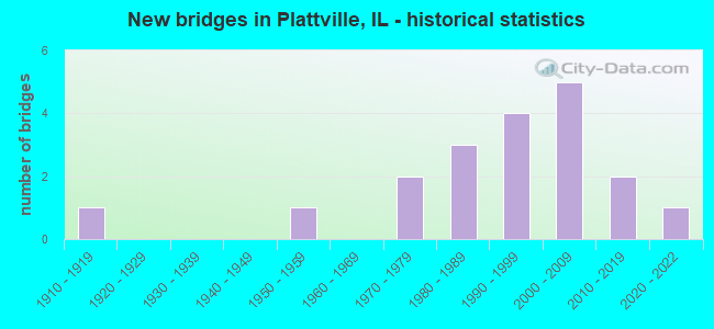
- New bridges - historical statistics
- 11910-1919
- 11950-1959
- 21970-1979
- 31980-1989
- 41990-1999
- 52000-2009
- 22010-2019
- 12020-2022


- Bridge Condition - Deck
- 10.0%Excellent
- 60.0%Good
- 20.0%Satisfactory
- 10.0%Fair

- Bridge Condition - Superstructure
- 10.0%Excellent
- 60.0%Good
- 20.0%Satisfactory
- 10.0%Fair

- Bridge Condition - Substructure
- 20.0%Excellent
- 40.0%Very good
- 30.0%Good
- 10.0%Fair

- Bridge Condition - Channel
- 26.3%Very good
- 31.6%Good
- 26.3%Satisfactory
- 10.5%Fair
- 5.3%Poor

- Bridge Condition - Culverts
- 55.6%Very good
- 11.1%Good
- 22.2%Satisfactory
- 11.1%Fair
Find on map >> Show street view
Structure Number: 472005, Location: 0.55 MI E OF ILL 47 (Lat: 41.510106, Lng: -88.427942), Route carried "on" structure: US 52, Year Built: 1982, Status: Open, Structure Length: 0.73m (2.40ft), Average Daily Traffic: 4,050 (year 2021), Truck Traffic: 23%, Average Future Daily Traffic: 4,672 (year 2032), Design Load: HS 20, Features Intersected: LISBON CR
Minimum Vertical Clearance: 30+ m (98+ ft), Kilometerpoint: 196.560, Lanes on structure: 2, Base Highway Network: Yes, Owner: State Highway Agency, Approaching Roadway Width: 6.7m (22.0ft), Material/Design: Concrete continuous, Design/Construction: Culvert, Number Of Spans In Main Unit: 2, Length of Maximum Span: 3.4m (11.2ft), Curb-To-Curb Width: 12.2m (40.0ft), Out-to-Out Width: 12.2m (40.0ft)
Condition: Channel: Good, Culverts: Good, Operating Rating: 59.6 metric tons, Method Used To Determine Operating Rating: Load Factor (LF) rating reported by rating factor (RF) method using MS18 loading, Inventory Rating: 35.3 metric tons, Method Used To Determine Inventory Rating: Load Factor (LF) rating reported by rating factor (RF) method using MS18 loading, Structural Evaluation: Better than present minimum criteria, Deck Geometry: Equal to present minimum criteria, Waterway Adequacy: Equal to present desirable criteria, Approach Roadway Alignment: Equal to present desirable criteria, Designated Inspection Frequency: Every 48 months, Inspection Date: January 2019, Deck Structure Type: Concrete Cast-file-Place
Find on map >> Show street view
Structure Number: 472019, Location: 2.2 MI E OF IL 47 (Lat: 41.510989, Lng: -88.394469), Route carried "on" structure: US 52, Year Built: 2009, Status: Open, Structure Length: 0.86m (2.82ft), Average Daily Traffic: 4,050 (year 2021), Truck Traffic: 23%, Average Future Daily Traffic: 4,672 (year 2032), Design Load: HS 20, Features Intersected: AUX SABLE CR
Minimum Vertical Clearance: 30+ m (98+ ft), Kilometerpoint: 199.360, Lanes on structure: 2, Base Highway Network: Yes, Owner: State Highway Agency, Approaching Roadway Width: 11.0m (36.1ft), Skew: 3 degrees, Material/Design: Concrete, Design/Construction: Culvert, Number Of Spans In Main Unit: 2, Length of Maximum Span: 0.6m (2.0ft), Curb-To-Curb Width: 11.0m (36.1ft), Out-to-Out Width: 16.5m (54.1ft)
Condition: Channel: Very good, Culverts: Very good, Operating Rating: 54.1 metric tons, Method Used To Determine Operating Rating: Load Factor (LF) rating reported by rating factor (RF) method using MS18 loading, Inventory Rating: 32.4 metric tons, Method Used To Determine Inventory Rating: Load Factor (LF) rating reported by rating factor (RF) method using MS18 loading, Structural Evaluation: Equal to present desirable criteria, Deck Geometry: Somewhat better than minimum adequacy, Waterway Adequacy: Equal to present desirable criteria, Approach Roadway Alignment: Equal to present desirable criteria, Designated Inspection Frequency: Every 48 months, Inspection Date: January 2019
Find on map >> Show street view
Structure Number: 47202, Location: 2 MI E OF IL 47 (Lat: 41.511131, Lng: -88.395050), Route carried "on" structure: Other road , Year Built: 2009, Status: Open, Structure Length: 0.85m (2.79ft), Average Daily Traffic: 10 (year 2019), Average Future Daily Traffic: 15 (year 2032), Design Load: HS 20, Features Intersected: LISBON CR/DITCH, Facility Carried by Structure: PVT FIELD ENTR
Minimum Vertical Clearance: 30+ m (98+ ft), Kilometerpoint: 0.016, Lanes on structure: 1, Owner: State Highway Agency, Approaching Roadway Width: 7.3m (24.0ft), Material/Design: Concrete, Design/Construction: Culvert, Number Of Spans In Main Unit: 2, Length of Maximum Span: 3.7m (12.1ft), Curb-To-Curb Width: 7.3m (24.0ft), Out-to-Out Width: 12.2m (40.0ft)
Condition: Channel: Very good, Culverts: Very good, Operating Rating: 54.1 metric tons, Method Used To Determine Operating Rating: Load Factor (LF) rating reported by rating factor (RF) method using MS18 loading, Inventory Rating: 32.4 metric tons, Method Used To Determine Inventory Rating: Load Factor (LF) rating reported by rating factor (RF) method using MS18 loading, Structural Evaluation: Equal to present desirable criteria, Deck Geometry: Equal to present minimum criteria, Waterway Adequacy: Equal to present desirable criteria, Approach Roadway Alignment: Equal to present desirable criteria, Designated Inspection Frequency: Every 48 months, Inspection Date: December 2020
Find on map >> Show street view
Structure Number: 472032, Location: .74 M N of US 52 (Lat: 41.520644, Lng: -88.433725), Route carried "on" structure: State highway 47, Year Built: 2018, Status: Open, Structure Length: 0.99m (3.25ft), Average Daily Traffic: 7,400 (year 2021), Truck Traffic: 25%, Average Future Daily Traffic: 11,501 (year 2038), Design Load: HS 25 or greater, Features Intersected: Trib of Aux Sable Cr
Minimum Vertical Clearance: 30+ m (98+ ft), Kilometerpoint: 159.755, Lanes on structure: 4, Base Highway Network: Yes, Owner: State Highway Agency, Approaching Roadway Width: 21.9m (71.9ft), Skew: 13 degrees, Material/Design: Concrete, Design/Construction: Culvert, Number Of Spans In Main Unit: 2, Length of Maximum Span: 4.6m (15.1ft), Curb-To-Curb Width: 21.9m (71.9ft), Out-to-Out Width: 50.0m (164.0ft)
Condition: Channel: Very good, Culverts: Very good, Operating Rating: 42.8 metric tons, Method Used To Determine Operating Rating: Load and Resistance Factor Rating (LRFR) rating reported by rating factor(RF) method using HL-93 loadings, Inventory Rating: 33.0 metric tons, Method Used To Determine Inventory Rating: Load and Resistance Factor Rating (LRFR) rating reported by rating factor(RF) method using HL-93 loadings, Structural Evaluation: Equal to present desirable criteria, Deck Geometry: Superior to present desirable criteria, Waterway Adequacy: Equal to present desirable criteria, Approach Roadway Alignment: Equal to present desirable criteria, Designated Inspection Frequency: Every 48 months, Inspection Date: August 2021
Find on map >> Show street view
Structure Number: 473055, Location: 1 MI S OF PLATVILLE (Lat: 41.518122, Lng: -88.385392), Route carried "on" structure: County highway , Year Built: 1959, Status: Open, Structure Length: 2.53m (8.30ft), Average Daily Traffic: 125 (year 2019), Truck Traffic: 11%, Average Future Daily Traffic: 219 (year 2032), Design Load: HS 15, Features Intersected: W. AUX SABLE, Facility Carried by Structure: CHURCH RD
Minimum Vertical Clearance: 30+ m (98+ ft), Kilometerpoint: 0.837, Lanes on structure: 1, Owner: Town or Township Highway Agency, Approaching Roadway Width: 6.1m (20.0ft), Skew: 2 degrees, Material/Design: Concrete, Design/Construction: Slab, Number Of Spans In Main Unit: 3, Length of Maximum Span: 9.4m (30.8ft), Curb-To-Curb Width: 7.3m (24.0ft), Out-to-Out Width: 7.9m (25.9ft)
Condition: Deck: Satisfactory, Superstructure: Satisfactory, Substructure: Good, Channel: Satisfactory, Operating Rating: 48.0 metric tons, Method Used To Determine Operating Rating: Load Factor (LF) rating reported by rating factor (RF) method using MS18 loading, Inventory Rating: 28.8 metric tons, Method Used To Determine Inventory Rating: Load Factor (LF) rating reported by rating factor (RF) method using MS18 loading, Structural Evaluation: Equal to present minimum criteria, Deck Geometry: Somewhat better than minimum adequacy, Waterway Adequacy: Equal to present minimum criteria, Approach Roadway Alignment: Equal to present minimum criteria, Designated Inspection Frequency: Every 24 months, Inspection Date: August 2020, Deck Structure Type: Concrete Cast-file-Place, Wearing Surface/Protective System: Wearing Surface: Gravel
Find on map >> Show street view
Structure Number: 473067, Location: 0.88 MI SW OF CH 8 (Lat: 41.526442, Lng: -88.399108), Route carried "on" structure: City street , Year Built: 1910, Status: Open, Structure Length: 1.04m (3.41ft), Average Daily Traffic: 75 (year 2020), Average Future Daily Traffic: 110 (year 2032), Features Intersected: BR W AUX SABLE CR, Facility Carried by Structure: CHICAGO RD/MS0025
Minimum Vertical Clearance: 30+ m (98+ ft), Kilometerpoint: 0.435, Lanes on structure: 1, Owner: City or Municipal Highway Agency, Approaching Roadway Width: 6.1m (20.0ft), Material/Design: Concrete, Design/Construction: Channel Beam, Number Of Spans In Main Unit: 1, Length of Maximum Span: 9.1m (29.9ft), Curb-To-Curb Width: 6.9m (22.6ft), Out-to-Out Width: 6.9m (22.6ft)
Condition: Deck: Good, Superstructure: Good, Substructure: Fair, Channel: Satisfactory, Operating Rating: 39.5 metric tons, Method Used To Determine Operating Rating: Load Factor (LF) rating reported by rating factor (RF) method using MS18 loading, Inventory Rating: 23.7 metric tons, Method Used To Determine Inventory Rating: Load Factor (LF) rating reported by rating factor (RF) method using MS18 loading, Structural Evaluation: Somewhat better than minimum adequacy, Deck Geometry: Somewhat better than minimum adequacy, Waterway Adequacy: Equal to present minimum criteria, Approach Roadway Alignment: Equal to present desirable criteria, Designated Inspection Frequency: Every 24 months, Inspection Date: December 2021, Deck Structure Type: Concrete Precast Panels, Wearing Surface/Protective System: Wearing Surface: Gravel
Find on map >> Show street view
Structure Number: 473085, Location: 1 MI N OF ILL RT 52 (Lat: 41.527786, Lng: -88.365908), Route carried "on" structure: City street , Year Built: 1971, Status: Open, Structure Length: 1.49m (4.89ft), Average Daily Traffic: 225 (year 2019), Truck Traffic: 11%, Average Future Daily Traffic: 183 (year 2032), Design Load: HS 15, Features Intersected: WEST AUX SABLE CK, Facility Carried by Structure: BRISBIN RD/MS0020
Minimum Vertical Clearance: 30+ m (98+ ft), Kilometerpoint: 2.253, Lanes on structure: 2, Owner: City or Municipal Highway Agency, Approaching Roadway Width: 6.7m (22.0ft), Material/Design: Prestressed concrete, Design/Construction: Box Beam or Girders - Multiple, Number Of Spans In Main Unit: 1, Length of Maximum Span: 14.9m (48.9ft), Curb-To-Curb Width: 6.7m (22.0ft), Out-to-Out Width: 6.7m (22.0ft)
Condition: Deck: Fair, Superstructure: Fair, Substructure: Good, Channel: Satisfactory, Operating Rating: 32.4 metric tons, Method Used To Determine Operating Rating: Load Factor (LF) rating reported by rating factor (RF) method using MS18 loading, Inventory Rating: 19.4 metric tons, Method Used To Determine Inventory Rating: Load Factor (LF) rating reported by rating factor (RF) method using MS18 loading, Structural Evaluation: Somewhat better than minimum adequacy, Deck Geometry: Meets minimum limits, Waterway Adequacy: Somewhat better than minimum adequacy, Approach Roadway Alignment: Equal to present desirable criteria, Designated Inspection Frequency: Every 24 months, Inspection Date: December 2021, Deck Structure Type: Concrete Precast Panels, Wearing Surface/Protective System: Wearing Surface: Gravel
Find on map >> Show street view
Structure Number: 473103, Location: 2 MI E OF ILL 47 (Lat: 41.547328, Lng: -88.393422), Route carried "on" structure: County highway , Year Built: 1979, Status: Open, Structure Length: 0.79m (2.59ft), Average Daily Traffic: 75 (year 2019), Truck Traffic: 13%, Average Future Daily Traffic: 183 (year 2032), Design Load: HS 20, Features Intersected: AUX SABLE CK, Facility Carried by Structure: HELMAR RD
Minimum Vertical Clearance: 30+ m (98+ ft), Kilometerpoint: 12.392, Lanes on structure: 2, Owner: Town or Township Highway Agency, Approaching Roadway Width: 6.7m (22.0ft), Skew: 2 degrees, Material/Design: Concrete continuous, Design/Construction: Culvert, Number Of Spans In Main Unit: 2, Length of Maximum Span: 3.7m (12.1ft), Curb-To-Curb Width: 8.5m (27.9ft), Out-to-Out Width: 8.5m (27.9ft)
Condition: Channel: Poor, Culverts: Fair, Operating Rating: 44.1 metric tons, Method Used To Determine Operating Rating: Assigned rating based on Load Factor Design (LFD) reported by rating factor (RF) using MS18 loading, Inventory Rating: 32.4 metric tons, Method Used To Determine Inventory Rating: Assigned rating based on Load Factor Design (LFD) reported by rating factor (RF) using MS18 loading, Structural Evaluation: Somewhat better than minimum adequacy, Deck Geometry: Better than present minimum criteria, Waterway Adequacy: Equal to present minimum criteria, Approach Roadway Alignment: Better than present minimum criteria, Designated Inspection Frequency: Every 24 months, Inspection Date: August 2020
Find on map >> Show street view
Structure Number: 47312, Location: 1.5 MI N OF ILL 52 (Lat: 41.531364, Lng: -88.365939), Route carried "on" structure: City street , Year Built: 1981, Status: Open, Structure Length: 2.01m (6.59ft), Average Daily Traffic: 225 (year 2019), Truck Traffic: 11%, Average Future Daily Traffic: 183 (year 2032), Design Load: HS 20, Features Intersected: W AUX SABLE CK, Facility Carried by Structure: BR1SBIN RD/MS0020
Minimum Vertical Clearance: 30+ m (98+ ft), Kilometerpoint: 1.851, Lanes on structure: 2, Owner: City or Municipal Highway Agency, Approaching Roadway Width: 7.3m (24.0ft), Skew: 2 degrees, Material/Design: Prestressed concrete, Design/Construction: Box Beam or Girders - Multiple, Number Of Spans In Main Unit: 1, Length of Maximum Span: 19.2m (63.0ft), Curb-To-Curb Width: 8.2m (26.9ft), Out-to-Out Width: 8.2m (26.9ft)
Condition: Deck: Satisfactory, Superstructure: Satisfactory, Substructure: Good, Channel: Fair, Operating Rating: 57.7 metric tons, Method Used To Determine Operating Rating: Load Factor (LF) rating reported by rating factor (RF) method using MS18 loading, Inventory Rating: 34.7 metric tons, Method Used To Determine Inventory Rating: Load Factor (LF) rating reported by rating factor (RF) method using MS18 loading, Structural Evaluation: Equal to present minimum criteria, Deck Geometry: Somewhat better than minimum adequacy, Waterway Adequacy: Meets minimum limits, Approach Roadway Alignment: Equal to present desirable criteria, Designated Inspection Frequency: Every 24 months, Inspection Date: December 2021, Deck Structure Type: Concrete Precast Panels, Wearing Surface/Protective System: Wearing Surface: Gravel
Find on map >> Show street view
Structure Number: 473124, Location: 1.14 MI N OF ILL 52 (Lat: 41.527214, Lng: -88.404764), Route carried "on" structure: County highway , Year Built: 1985, Status: Open, Structure Length: 0.73m (2.40ft), Average Daily Traffic: 400 (year 2019), Truck Traffic: 7%, Average Future Daily Traffic: 402 (year 2032), Design Load: H 20, Features Intersected: AUX SABLE DRAINAGE, Facility Carried by Structure: ASHLEY RD TR 86
Minimum Vertical Clearance: 30+ m (98+ ft), Kilometerpoint: 3.798, Lanes on structure: 2, Owner: Town or Township Highway Agency, Approaching Roadway Width: 7.3m (24.0ft), Material/Design: Concrete continuous, Design/Construction: Culvert, Number Of Spans In Main Unit: 2, Length of Maximum Span: 3.4m (11.2ft), Curb-To-Curb Width: 6.1m (20.0ft), Out-to-Out Width: 6.1m (20.0ft)
Condition: Channel: Satisfactory, Culverts: Satisfactory, Operating Rating: 64.5 metric tons, Method Used To Determine Operating Rating: Load Factor (LF) rating reported by rating factor (RF) method using MS18 loading, Inventory Rating: 38.6 metric tons, Method Used To Determine Inventory Rating: Load Factor (LF) rating reported by rating factor (RF) method using MS18 loading, Structural Evaluation: Equal to present minimum criteria, Deck Geometry: Meets minimum limits, Waterway Adequacy: Better than present minimum criteria, Approach Roadway Alignment: Better than present minimum criteria, Designated Inspection Frequency: Every 24 months, Inspection Date: August 2020
Find on map >> Show street view
Structure Number: 473137, Location: CHURCHRD1/4MSCHICAGR (Lat: 41.525978, Lng: -88.385489), Route carried "on" structure: City street , Year Built: 1993, Status: Open, Structure Length: 1.23m (4.04ft), Average Daily Traffic: 150 (year 2019), Average Future Daily Traffic: 183 (year 2032), Design Load: HS 20, Features Intersected: W. AUX SABLE CREEK, Facility Carried by Structure: CHURCH RD/MS0015
Minimum Vertical Clearance: 30+ m (98+ ft), Kilometerpoint: 1.577, Lanes on structure: 2, Owner: City or Municipal Highway Agency, Approaching Roadway Width: 7.9m (25.9ft), Material/Design: Prestressed concrete, Design/Construction: Box Beam or Girders - Multiple, Number Of Spans In Main Unit: 1, Length of Maximum Span: 12.3m (40.4ft), Curb-To-Curb Width: 8.2m (26.9ft), Out-to-Out Width: 8.2m (26.9ft)
Condition: Deck: Good, Superstructure: Good, Substructure: Very good, Channel: Fair, Operating Rating: 44.1 metric tons, Method Used To Determine Operating Rating: Assigned rating based on Load Factor Design (LFD) reported by rating factor (RF) using MS18 loading, Inventory Rating: 32.4 metric tons, Method Used To Determine Inventory Rating: Assigned rating based on Load Factor Design (LFD) reported by rating factor (RF) using MS18 loading, Structural Evaluation: Better than present minimum criteria, Deck Geometry: Somewhat better than minimum adequacy, Waterway Adequacy: Better than present minimum criteria, Approach Roadway Alignment: Better than present minimum criteria, Designated Inspection Frequency: Every 48 months, Inspection Date: December 2021, Deck Structure Type: Concrete Precast Panels, Wearing Surface/Protective System: Wearing Surface: Gravel
Find on map >> Show street view
Structure Number: 47314, Location: 1.5 MI W OF GROVERD (Lat: 41.533361, Lng: -88.375667), Route carried "on" structure: County highway , Year Built: 1995, Status: Open, Structure Length: 2.30m (7.55ft), Average Daily Traffic: 350 (year 2019), Truck Traffic: 9%, Average Future Daily Traffic: 657 (year 2032), Design Load: HS 20, Features Intersected: AUX SABLE CK, Facility Carried by Structure: CHICAGO RD
Minimum Vertical Clearance: 30+ m (98+ ft), Kilometerpoint: 2.189, Lanes on structure: 2, Owner: County Highway Agency, Approaching Roadway Width: 8.5m (27.9ft), Skew: 3 degrees, Material/Design: Concrete, Design/Construction: Slab, Number Of Spans In Main Unit: 3, Length of Maximum Span: 7.6m (24.9ft), Curb-To-Curb Width: 8.5m (27.9ft), Out-to-Out Width: 9.3m (30.5ft)
Condition: Deck: Good, Superstructure: Good, Substructure: Very good, Channel: Good, Operating Rating: 67.4 metric tons, Method Used To Determine Operating Rating: Load Factor (LF) rating reported by rating factor (RF) method using MS18 loading, Inventory Rating: 40.2 metric tons, Method Used To Determine Inventory Rating: Load Factor (LF) rating reported by rating factor (RF) method using MS18 loading, Structural Evaluation: Better than present minimum criteria, Deck Geometry: Equal to present minimum criteria, Waterway Adequacy: Equal to present minimum criteria, Approach Roadway Alignment: Equal to present desirable criteria, Designated Inspection Frequency: Every 48 months, Inspection Date: August 2018, Deck Structure Type: Concrete Cast-file-Place, Wearing Surface/Protective System: Deck Protection: Epoxy Coated Reinforcing
Find on map >> Show street view
Structure Number: 473141, Location: 0.7 MI E OF RTE 47 (Lat: 41.532128, Lng: -88.419314), Route carried "on" structure: County highway , Year Built: 1995, Status: Open, Structure Length: 0.79m (2.59ft), Average Daily Traffic: 300 (year 2019), Truck Traffic: 8%, Average Future Daily Traffic: 475 (year 2032), Design Load: HS 20, Features Intersected: AUX SABLE CREEK, Facility Carried by Structure: PLATTVILLE RD
Minimum Vertical Clearance: 30+ m (98+ ft), Kilometerpoint: 6.003, Lanes on structure: 2, Owner: County Highway Agency, Approaching Roadway Width: 8.5m (27.9ft), Material/Design: Concrete, Design/Construction: Culvert, Number Of Spans In Main Unit: 2, Length of Maximum Span: 3.7m (12.1ft)
Condition: Channel: Good, Culverts: Satisfactory, Operating Rating: 66.4 metric tons, Method Used To Determine Operating Rating: Load Factor (LF) rating reported by rating factor (RF) method using MS18 loading, Inventory Rating: 39.9 metric tons, Method Used To Determine Inventory Rating: Load Factor (LF) rating reported by rating factor (RF) method using MS18 loading, Structural Evaluation: Equal to present minimum criteria, Waterway Adequacy: Equal to present desirable criteria, Approach Roadway Alignment: Equal to present desirable criteria, Designated Inspection Frequency: Every 24 months, Inspection Date: August 2020
Find on map >> Show street view
Structure Number: 473153, Location: 6 MI NE LISBON (Lat: 41.533222, Lng: -88.385517), Route carried "on" structure: City street , Year Built: 1999, Status: Open, Structure Length: 2.12m (6.96ft), Average Daily Traffic: 75 (year 2019), Average Future Daily Traffic: 110 (year 2032), Design Load: HS 20, Features Intersected: W AUX SABLE CREEK, Facility Carried by Structure: CHURCH RD/MS0015
Minimum Vertical Clearance: 30+ m (98+ ft), Kilometerpoint: 0.772, Lanes on structure: 2, Owner: City or Municipal Highway Agency, Approaching Roadway Width: 9.8m (32.2ft), Skew: 2 degrees, Material/Design: Concrete, Design/Construction: Box Beam or Girders - Multiple, Number Of Spans In Main Unit: 1, Length of Maximum Span: 20.3m (66.6ft), Curb-To-Curb Width: 8.5m (27.9ft), Out-to-Out Width: 8.5m (27.9ft)
Condition: Deck: Good, Superstructure: Good, Substructure: Very good, Channel: Satisfactory, Operating Rating: 44.1 metric tons, Method Used To Determine Operating Rating: Assigned rating based on Load Factor Design (LFD) reported by rating factor (RF) using MS18 loading, Inventory Rating: 32.4 metric tons, Method Used To Determine Inventory Rating: Assigned rating based on Load Factor Design (LFD) reported by rating factor (RF) using MS18 loading, Structural Evaluation: Better than present minimum criteria, Deck Geometry: Better than present minimum criteria, Waterway Adequacy: Better than present minimum criteria, Approach Roadway Alignment: Equal to present desirable criteria, Designated Inspection Frequency: Every 48 months, Inspection Date: December 2021, Deck Structure Type: Concrete Precast Panels
Find on map >> Show street view
Structure Number: 473157, Location: 0.15 MI N OF US 52 (Lat: 41.513933, Lng: -88.404783), Route carried "on" structure: County highway , Year Built: 2001, Status: Open, Structure Length: 1.48m (4.86ft), Average Daily Traffic: 325 (year 2019), Truck Traffic: 10%, Average Future Daily Traffic: 438 (year 2032), Design Load: HS 20, Features Intersected: AUX SABLE CREEK, Facility Carried by Structure: TR 86 ASHLEY RD
Minimum Vertical Clearance: 30+ m (98+ ft), Kilometerpoint: 5.279, Lanes on structure: 2, Owner: Town or Township Highway Agency, Approaching Roadway Width: 8.5m (27.9ft), Skew: 2 degrees, Material/Design: Prestressed concrete, Design/Construction: Box Beam or Girders - Multiple, Number Of Spans In Main Unit: 1, Length of Maximum Span: 14.0m (45.9ft), Curb-To-Curb Width: 9.1m (29.9ft), Out-to-Out Width: 9.1m (29.9ft)
Condition: Deck: Good, Superstructure: Good, Substructure: Excellent, Channel: Good, Operating Rating: 44.1 metric tons, Method Used To Determine Operating Rating: Assigned rating based on Load Factor Design (LFD) reported by rating factor (RF) using MS18 loading, Inventory Rating: 32.4 metric tons, Method Used To Determine Inventory Rating: Assigned rating based on Load Factor Design (LFD) reported by rating factor (RF) using MS18 loading, Structural Evaluation: Better than present minimum criteria, Deck Geometry: Equal to present minimum criteria, Waterway Adequacy: Better than present minimum criteria, Approach Roadway Alignment: Better than present minimum criteria, Designated Inspection Frequency: Every 48 months, Inspection Date: August 2018, Deck Structure Type: Concrete Precast Panels, Wearing Surface/Protective System: Wearing Surface: Gravel, Deck Protection: Epoxy Coated Reinforcing
Find on map >> Show street view
Structure Number: 473159, Location: 0.3 MI S OF ILL 52 (Lat: 41.507158, Lng: -88.404981), Route carried "on" structure: County highway , Year Built: 2004, Status: Open, Structure Length: 1.66m (5.45ft), Average Daily Traffic: 350 (year 2019), Truck Traffic: 9%, Average Future Daily Traffic: 365 (year 2032), Design Load: HS 20, Features Intersected: W AUX SABLE CR, Facility Carried by Structure: ASHLEY RD
Minimum Vertical Clearance: 30+ m (98+ ft), Kilometerpoint: 0.402, Lanes on structure: 2, Owner: Town or Township Highway Agency, Approaching Roadway Width: 10.4m (34.1ft), Material/Design: Prestressed concrete, Design/Construction: Box Beam or Girders - Multiple, Number Of Spans In Main Unit: 1, Length of Maximum Span: 16.1m (52.8ft), Curb-To-Curb Width: 9.1m (29.9ft), Out-to-Out Width: 9.1m (29.9ft)
Condition: Deck: Good, Superstructure: Good, Substructure: Very good, Channel: Very good, Operating Rating: 44.1 metric tons, Method Used To Determine Operating Rating: Assigned rating based on Load Factor Design (LFD) reported by rating factor (RF) using MS18 loading, Inventory Rating: 32.4 metric tons, Method Used To Determine Inventory Rating: Assigned rating based on Load Factor Design (LFD) reported by rating factor (RF) using MS18 loading, Structural Evaluation: Better than present minimum criteria, Deck Geometry: Equal to present minimum criteria, Waterway Adequacy: Equal to present desirable criteria, Approach Roadway Alignment: Equal to present desirable criteria, Designated Inspection Frequency: Every 48 months, Inspection Date: Febuary 2022, Deck Structure Type: Concrete Precast Panels, Wearing Surface/Protective System: Wearing Surface: Gravel
Find on map >> Show street view
Structure Number: 473164, Location: 0.2 MI W OF RTE 47 (Lat: 41.546233, Lng: -88.436567), Route carried "on" structure: County highway , Year Built: 2007, Status: Open, Structure Length: 0.67m (2.20ft), Average Daily Traffic: 175 (year 2019), Truck Traffic: 17%, Average Future Daily Traffic: 256 (year 2032), Design Load: HS 20, Features Intersected: BR WEST AUX SABLE CR, Facility Carried by Structure: TR 93 HELMAR RD
Minimum Vertical Clearance: 30+ m (98+ ft), Kilometerpoint: 8.771, Lanes on structure: 2, Owner: Town or Township Highway Agency, Approaching Roadway Width: 10.4m (34.1ft), Material/Design: Concrete, Design/Construction: Culvert, Number Of Spans In Main Unit: 2, Length of Maximum Span: 3.3m (10.8ft)
Condition: Channel: Good, Culverts: Very good, Operating Rating: 44.1 metric tons, Method Used To Determine Operating Rating: Assigned rating based on Load Factor Design (LFD) reported by rating factor (RF) using MS18 loading, Inventory Rating: 32.4 metric tons, Method Used To Determine Inventory Rating: Assigned rating based on Load Factor Design (LFD) reported by rating factor (RF) using MS18 loading, Structural Evaluation: Equal to present desirable criteria, Waterway Adequacy: Equal to present desirable criteria, Approach Roadway Alignment: Equal to present desirable criteria, Designated Inspection Frequency: Every 48 months, Inspection Date: December 2021, Deck Structure Type: Concrete Cast-file-Place
Find on map >> Show street view
Structure Number: 473176, Location: T35N R7E SEC.10 (Lat: 41.519900, Lng: -88.418150), Route carried "on" structure: County highway , Year Built: 2015, Status: Open, Structure Length: 0.66m (2.17ft), Average Daily Traffic: 25 (year 2019), Average Future Daily Traffic: 47 (year 2038), Design Load: HS 25 or greater, Features Intersected: W.AUX SABLE CREEK TR, Facility Carried by Structure: TR 111 CHICAGO ROA
Minimum Vertical Clearance: 30+ m (98+ ft), Kilometerpoint: 2.945, Lanes on structure: 2, Owner: Town or Township Highway Agency, Approaching Roadway Width: 7.9m (25.9ft), Skew: 4 degrees, Material/Design: Concrete, Design/Construction: Culvert, Number Of Spans In Main Unit: 2, Length of Maximum Span: 3.4m (11.2ft), Curb-To-Curb Width: 14.0m (45.9ft)
Condition: Channel: Good, Culverts: Very good, Operating Rating: 42.1 metric tons, Method Used To Determine Operating Rating: Assigned ratings based on Load and Resistance Factor Design (LRFD) reported by rating factor (RF) using HL93 loadings, Inventory Rating: 32.4 metric tons, Method Used To Determine Inventory Rating: Assigned ratings based on Load and Resistance Factor Design (LRFD) reported by rating factor (RF) using HL93 loadings, Structural Evaluation: Equal to present desirable criteria, Deck Geometry: Superior to present desirable criteria, Waterway Adequacy: Equal to present desirable criteria, Approach Roadway Alignment: Equal to present desirable criteria, Designated Inspection Frequency: Every 48 months, Inspection Date: December 2021, Deck Structure Type: Concrete Cast-file-Place
Find on map >> Show street view
Structure Number: 473177, Location: 1.5 MI N of US RTE 5 (Lat: 41.532886, Lng: -88.351786), Route carried "on" structure: County highway , Year Built: 2020, Status: Open, Structure Length: 4.45m (14.60ft), Average Daily Traffic: 2,300 (year 2019), Truck Traffic: 9%, Average Future Daily Traffic: 3,500 (year 2043), Design Load: HS 25 or greater, Features Intersected: West Aux Sable Creek, Facility Carried by Structure: C.H. 2 (Grove Road
Minimum Vertical Clearance: 30+ m (98+ ft), Kilometerpoint: 8.191, Lanes on structure: 2, Owner: County Highway Agency, Approaching Roadway Width: 12.8m (42.0ft), Material/Design: Prestressed concrete, Design/Construction: Stringer/Multi-beam, Number Of Spans In Main Unit: 3, Length of Maximum Span: 18.3m (60.0ft), Curb-To-Curb Width: 12.2m (40.0ft), Out-to-Out Width: 13.2m (43.3ft)
Condition: Deck: Excellent, Superstructure: Excellent, Substructure: Excellent, Channel: Very good, Operating Rating: 70.6 metric tons, Method Used To Determine Operating Rating: Load and Resistance Factor Rating (LRFR) rating reported by rating factor(RF) method using HL-93 loadings, Inventory Rating: 54.4 metric tons, Method Used To Determine Inventory Rating: Load and Resistance Factor Rating (LRFR) rating reported by rating factor(RF) method using HL-93 loadings, Structural Evaluation: Superior to present desirable criteria, Deck Geometry: Equal to present minimum criteria, Waterway Adequacy: Superior to present desirable criteria, Approach Roadway Alignment: Superior to present desirable criteria, Designated Inspection Frequency: Every 24 months, Inspection Date: December 2020, Deck Structure Type: Concrete Cast-file-Place, Wearing Surface/Protective System: Deck Protection: Epoxy Coated Reinforcing