Bridge Statistics for Platea, Pennsylvania (PA)
Condition, Traffic, Stress, Structural Evaluation, Project Costs
- National Bridge Inventory (NBI) Statistics
- 30Number of bridges
- 282ft / 86.1mTotal length
- $3,321,000Total costs
- 198,810Total average daily traffic
- 41,164Total average daily truck traffic
- National Bridge Inventory (NBI) Registered Bridges for Platea
- No street view available for this location
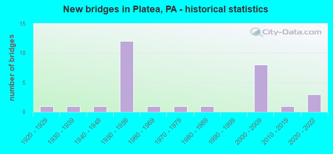
- New bridges - historical statistics
- 11920-1929
- 11930-1939
- 11940-1949
- 121950-1959
- 11960-1969
- 11970-1979
- 11980-1989
- 82000-2009
- 12010-2019
- 32020-2022

- Reconstructed bridges - Historical Statistics
- 51970-1979
- 11980-1989
- 01990-1999
- 02000-2009
- 12010-2019


- Bridge Condition - Deck
- 11.8%Excellent
- 5.9%Very good
- 23.5%Good
- 29.4%Satisfactory
- 17.6%Fair
- 11.8%Poor

- Bridge Condition - Superstructure
- 5.9%Excellent
- 23.5%Very good
- 11.8%Good
- 47.1%Fair
- 5.9%Poor
- 5.9%Serious

- Bridge Condition - Substructure
- 5.9%Excellent
- 17.6%Very good
- 17.6%Good
- 23.5%Satisfactory
- 35.3%Fair

- Bridge Condition - Channel
- 25.0%Very good
- 25.0%Good
- 33.3%Satisfactory
- 16.7%Fair

- Bridge Condition - Culverts
- 33.3%Very good
- 33.3%Satisfactory
- 33.3%Fair
Find on map >> Show street view
Structure Number: 1904, Location: OVER 02328 & GIRTY'S RUN (Lat: 40.522000, Lng: -80.005506), Route carried "on" structure: US 19T, Year Built: 1946, Status: Open, Structure Length: 6.74m (22.11ft), Average Daily Traffic: 37,610 (year 2022), Truck Traffic: 2%, Average Future Daily Traffic: 35,553 (year 2032), Design Load: HS 20, Features Intersected: BABCOCK BLVD,GIRDY'S RUN, Facility Carried by Structure: MCKNIGHT RD
Minimum Vertical Clearance: 30+ m (98+ ft), Kilometerpoint: 3.438, Lanes on structure: 4, Lanes under structure: 4, Base Highway Network: Yes, Owner: State Highway Agency, Approaching Roadway Width: 16.5m (54.1ft), Skew: 30 degrees, Material/Design: Concrete continuous, Design/Construction: Tee Beam, Number Of Spans In Main Unit: 3, Length of Maximum Span: 21.3m (69.9ft), Curb or Sidewalk Widths: Left: 1.5m (4.9ft), Right: 1.5m (4.9ft), Curb-To-Curb Width: 16.5m (54.1ft), Out-to-Out Width: 20.7m (67.9ft)
Condition: Deck: Fair, Superstructure: Fair, Substructure: Satisfactory, Channel: Satisfactory, Operating Rating: 54.4 metric tons, Method Used To Determine Operating Rating: Load Factor (LF), Inventory Rating: 32.7 metric tons, Method Used To Determine Inventory Rating: Load Factor (LF), Structural Evaluation: Somewhat better than minimum adequacy, Deck Geometry: Meets minimum limits, Underclear: Equal to present minimum criteria, Waterway Adequacy: Superior to present desirable criteria, Approach Roadway Alignment: Equal to present desirable criteria, Length Of Structure Improvement: 6.70m (21.98ft), Designated Inspection Frequency: Every 24 months, Inspection Date: April 2021, Bridge Improvement Cost: $107,000, Roadway Improvement Cost: $316,000, Total Project Cost: $1,449,000, Deck Structure Type: Concrete Cast-file-Place, Wearing Surface/Protective System: Wearing Surface: Latex Concrete
Find on map >> Show street view
Structure Number: 1588, Location: ELK CREEK TOWNSHIP (Lat: 41.926361, Lng: -80.339319), Route carried "on" structure: State highway 18, Year Built: 1923, Year Reconstructed: 1988, Status: Open, Structure Length: 0.76m (2.49ft), Average Daily Traffic: 3,865 (year 2020), Truck Traffic: 5%, Average Future Daily Traffic: 5,265 (year 2032), Design Load: HS 25 or greater, Features Intersected: OVER CONNEAUT CREEK BR
Minimum Vertical Clearance: 30+ m (98+ ft), Kilometerpoint: 10.462, Lanes on structure: 2, Base Highway Network: Yes, Owner: State Highway Agency, Approaching Roadway Width: 9.1m (29.9ft), Material/Design: Prestressed concrete, Design/Construction: Box Beam or Girders - Multiple, Number Of Spans In Main Unit: 1, Length of Maximum Span: 7.3m (24.0ft), Curb or Sidewalk Widths: Left: 0.2m (0.7ft), Right: 0.2m (0.7ft), Curb-To-Curb Width: 11.6m (38.1ft), Out-to-Out Width: 12.3m (40.4ft)
Condition: Deck: Good, Superstructure: Very good, Substructure: Good, Channel: Satisfactory, Operating Rating: 89.8 metric tons, Method Used To Determine Operating Rating: Load Factor (LF), Inventory Rating: 66.2 metric tons, Method Used To Determine Inventory Rating: Load Factor (LF), Structural Evaluation: Better than present minimum criteria, Deck Geometry: Somewhat better than minimum adequacy, Waterway Adequacy: Equal to present minimum criteria, Approach Roadway Alignment: Equal to present desirable criteria, Length Of Structure Improvement: 1.50m (4.92ft), Designated Inspection Frequency: Every 48 months, Inspection Date: October 2020, Deck Structure Type: Concrete Cast-file-Place, Wearing Surface/Protective System: Wearing Surface: Bituminous, Membrane: Preformed Fabric, Deck Protection: Epoxy Coated Reinforcing
Find on map >> Show street view
Structure Number: 15881, Location: PLATEA BOROUGH (Lat: 41.951097, Lng: -80.328900), Route carried "on" structure: State highway 18, Year Built: 1936, Status: Open, Structure Length: 1.62m (5.31ft), Average Daily Traffic: 3,865 (year 2020), Truck Traffic: 5%, Average Future Daily Traffic: 5,265 (year 2032), Design Load: H 20, Features Intersected: OVER B&LE R.R.& RUN
Minimum Vertical Clearance: 30+ m (98+ ft), Kilometerpoint: 13.765, Lanes on structure: 2, Base Highway Network: Yes, Owner: Railroad, Approaching Roadway Width: 10.1m (33.1ft), Skew: 3 degrees, Material/Design: Concrete, Design/Construction: Tee Beam, Number Of Spans In Main Unit: 1, Length of Maximum Span: 14.3m (46.9ft), Curb or Sidewalk Widths: Left: 1.6m (5.2ft), Right: 0.3m (1.0ft), Curb-To-Curb Width: 10.4m (34.1ft), Out-to-Out Width: 12.7m (41.7ft)
Condition: Deck: Satisfactory, Superstructure: Fair, Substructure: Fair, Channel: Very good, Operating Rating: 45.4 metric tons, Method Used To Determine Operating Rating: Field evaluation and documented engineering judgment, Inventory Rating: 32.7 metric tons, Method Used To Determine Inventory Rating: Field evaluation and documented engineering judgment, Structural Evaluation: Somewhat better than minimum adequacy, Deck Geometry: Somewhat better than minimum adequacy, Underclear: High priority of corrective action, Waterway Adequacy: Superior to present desirable criteria, Approach Roadway Alignment: Equal to present desirable criteria, Length Of Structure Improvement: 2.30m (7.55ft), Designated Inspection Frequency: Every 24 months, Inspection Date: December 2021, Deck Structure Type: Concrete Cast-file-Place, Wearing Surface/Protective System: Wearing Surface: Bituminous, Membrane: Preformed Fabric
Find on map >> Show street view
Structure Number: 15882, Location: GIRARD TOWNSHIP (Lat: 41.962642, Lng: -80.340497), Route carried "on" structure: State highway 18, Year Built: 1959, Year Reconstructed: 1982, Status: Closed, Structure Length: 6.07m (19.91ft), Average Daily Traffic: 3,795 (year 2022), Truck Traffic: 8%, Average Future Daily Traffic: 4,129 (year 2032), Design Load: HS 20, Features Intersected: OVER SR 90,EB/WB
Minimum Vertical Clearance: 30+ m (98+ ft), Kilometerpoint: 15.892, Lanes on structure: 2, Lanes under structure: 8, Base Highway Network: Yes, Owner: State Highway Agency, Approaching Roadway Width: 9.4m (30.8ft), Skew: 2 degrees, Material/Design: Steel continuous, Design/Construction: Stringer/Multi-beam, Number Of Spans In Main Unit: 2, Number Of Approach Spans: 2, Length of Maximum Span: 20.7m (67.9ft), Curb or Sidewalk Widths: Left: 0.2m (0.7ft), Right: 0.2m (0.7ft), Curb-To-Curb Width: 12.2m (40.0ft), Out-to-Out Width: 13.2m (43.3ft)
Condition: Deck: Poor, Superstructure: Serious, Substructure: Fair, Operating Rating: 58.1 metric tons, Method Used To Determine Operating Rating: Load Factor (LF), Inventory Rating: 34.5 metric tons, Method Used To Determine Inventory Rating: Load Factor (LF), Structural Evaluation: High priority of corrective action, Deck Geometry: Equal to present minimum criteria, Approach Roadway Alignment: Equal to present desirable criteria, Length Of Structure Improvement: 7.10m (23.29ft), Designated Inspection Frequency: Every 24 months, Other Special Inspection Frequency: Every 6 months, Inspection Date: September 2021, Other Special Inspection Date: September 2021, Bridge Improvement Cost: $20,000, Roadway Improvement Cost: $60,000, Total Project Cost: $275,000, Deck Structure Type: Concrete Cast-file-Place, Wearing Surface/Protective System: Wearing Surface: Bituminous, Membrane: Preformed Fabric, Deck Protection: Epoxy Coated Reinforcing
Find on map >> Show street view
Structure Number: 15897, Location: SPRINGFIELD TOWNSHIP (Lat: 41.973558, Lng: -80.389275), Route carried "on" structure: US 20, Year Built: 1951, Status: Open, Structure Length: 1.28m (4.20ft), Average Daily Traffic: 3,669 (year 2020), Truck Traffic: 5%, Average Future Daily Traffic: 4,254 (year 2032), Design Load: HS 20, Features Intersected: OVER CROOKED CREEK
Minimum Vertical Clearance: 30+ m (98+ ft), Kilometerpoint: 11.544, Lanes on structure: 4, Base Highway Network: Yes, Owner: State Highway Agency, Approaching Roadway Width: 21.0m (68.9ft), Skew: 23 degrees, Material/Design: Concrete, Design/Construction: Culvert, Number Of Spans In Main Unit: 1, Length of Maximum Span: 12.8m (42.0ft)
Condition: Channel: Fair, Culverts: Fair, Operating Rating: 68.0 metric tons, Method Used To Determine Operating Rating: Allowable Stress (AS), Inventory Rating: 40.8 metric tons, Method Used To Determine Inventory Rating: Allowable Stress (AS), Structural Evaluation: Somewhat better than minimum adequacy, Waterway Adequacy: Superior to present desirable criteria, Approach Roadway Alignment: Equal to present desirable criteria, Length Of Structure Improvement: 1.90m (6.23ft), Designated Inspection Frequency: Every 24 months, Inspection Date: March 2020
Find on map >> Show street view
Structure Number: 15898, Location: GIRARD TOWNSHIP (Lat: 41.977203, Lng: -80.380961), Route carried "on" structure: US 20, Year Built: 1951, Status: Open, Structure Length: 0.61m (2.00ft), Average Daily Traffic: 3,669 (year 2020), Truck Traffic: 5%, Average Future Daily Traffic: 4,254 (year 2032), Design Load: HS 20, Features Intersected: OVER TR.CROOKED CREEK
Minimum Vertical Clearance: 30+ m (98+ ft), Kilometerpoint: 12.278, Lanes on structure: 4, Base Highway Network: Yes, Owner: State Highway Agency, Approaching Roadway Width: 24.7m (81.0ft), Skew: 20 degrees, Material/Design: Concrete, Design/Construction: Culvert, Number Of Spans In Main Unit: 1, Length of Maximum Span: 6.1m (20.0ft)
Condition: Channel: Fair, Culverts: Satisfactory, Operating Rating: 75.3 metric tons, Method Used To Determine Operating Rating: Allowable Stress (AS), Inventory Rating: 45.4 metric tons, Method Used To Determine Inventory Rating: Allowable Stress (AS), Structural Evaluation: Equal to present minimum criteria, Waterway Adequacy: Superior to present desirable criteria, Approach Roadway Alignment: Equal to present desirable criteria, Length Of Structure Improvement: 1.20m (3.94ft), Designated Inspection Frequency: Every 48 months, Inspection Date: March 2020
Find on map >> Show street view
Structure Number: 15899, Location: GIRARD TOWNSHIP (Lat: 41.979539, Lng: -80.375372), Route carried "on" structure: US 20, Year Built: 1951, Status: Open, Structure Length: 4.39m (14.40ft), Average Daily Traffic: 3,669 (year 2020), Truck Traffic: 5%, Average Future Daily Traffic: 4,254 (year 2032), Design Load: HS 20, Features Intersected: OVER B & LE R R
Minimum Vertical Clearance: 30+ m (98+ ft), Kilometerpoint: 13.095, Lanes on structure: 4, Base Highway Network: Yes, Owner: State Highway Agency, Approaching Roadway Width: 25.0m (82.0ft), Skew: 23 degrees, Material/Design: Steel continuous, Design/Construction: Stringer/Multi-beam, Number Of Spans In Main Unit: 3, Length of Maximum Span: 15.2m (49.9ft), Curb or Sidewalk Widths: Left: 0.1m (0.3ft), Right: 0.1m (0.3ft), Curb-To-Curb Width: 25.5m (83.7ft), Out-to-Out Width: 26.8m (87.9ft)
Condition: Deck: Poor, Superstructure: Fair, Substructure: Fair, Operating Rating: 54.4 metric tons, Method Used To Determine Operating Rating: Load Factor (LF), Inventory Rating: 32.7 metric tons, Method Used To Determine Inventory Rating: Load Factor (LF), Structural Evaluation: Somewhat better than minimum adequacy, Deck Geometry: Superior to present desirable criteria, Underclear: High priority of corrective action, Approach Roadway Alignment: Equal to present desirable criteria, Length Of Structure Improvement: 5.30m (17.39ft), Designated Inspection Frequency: Every 24 months, Inspection Date: June 2021, Bridge Improvement Cost: $22,000, Roadway Improvement Cost: $66,000, Total Project Cost: $302,000, Deck Structure Type: Concrete Cast-file-Place, Wearing Surface/Protective System: Wearing Surface: Bituminous, Membrane: Preformed Fabric
Find on map >> Show street view
Structure Number: 16026, Location: GIRARD TOWNSHIP (Lat: 41.948256, Lng: -80.379650), Route carried "on" structure: Interstate 90, Year Built: 1959, Year Reconstructed: 1976, Status: Open, Structure Length: 5.33m (17.49ft), Average Daily Traffic: 10,982 (year 2022), Truck Traffic: 28%, Average Future Daily Traffic: 13,413 (year 2032), Design Load: HS 20+Mod, Features Intersected: OVER ABANDONED RAILROAD
Minimum Vertical Clearance: 30+ m (98+ ft), Kilometerpoint: 11.293, Lanes on structure: 2, Base Highway Network: Yes, Owner: State Highway Agency, Approaching Roadway Width: 11.6m (38.1ft), Skew: 13 degrees, Material/Design: Steel continuous, Design/Construction: Stringer/Multi-beam, Number Of Spans In Main Unit: 3, Length of Maximum Span: 17.1m (56.1ft), Curb or Sidewalk Widths: Left: 0.2m (0.7ft), Right: 0.2m (0.7ft), Curb-To-Curb Width: 12.2m (40.0ft), Out-to-Out Width: 13.1m (43.0ft)
Condition: Deck: Satisfactory, Superstructure: Fair, Substructure: Fair, Operating Rating: 55.3 metric tons, Method Used To Determine Operating Rating: Load Factor (LF), Inventory Rating: 33.6 metric tons, Method Used To Determine Inventory Rating: Load Factor (LF), Structural Evaluation: Somewhat better than minimum adequacy, Deck Geometry: Better than present minimum criteria, Underclear: High priority of corrective action, Approach Roadway Alignment: Equal to present desirable criteria, Length Of Structure Improvement: 6.30m (20.67ft), Designated Inspection Frequency: Every 24 months, Inspection Date: September 2021, Bridge Improvement Cost: $26,000, Roadway Improvement Cost: $77,000, Total Project Cost: $351,000, Deck Structure Type: Concrete Cast-file-Place, Wearing Surface/Protective System: Wearing Surface: Bituminous, Membrane: Preformed Fabric
Find on map >> Show street view
Structure Number: 16027, Location: GIRARD TOWNSHIP (Lat: 41.948500, Lng: -80.379667), Route carried "on" structure: Interstate 90, Year Built: 1959, Year Reconstructed: 1976, Status: Open, Structure Length: 5.33m (17.49ft), Average Daily Traffic: 11,489 (year 2022), Truck Traffic: 27%, Average Future Daily Traffic: 13,307 (year 2032), Design Load: HS 20+Mod, Features Intersected: OVER ABANDONED RAILROAD
Minimum Vertical Clearance: 30+ m (98+ ft), Kilometerpoint: 11.257, Lanes on structure: 2, Base Highway Network: Yes, Owner: State Highway Agency, Approaching Roadway Width: 11.6m (38.1ft), Skew: 13 degrees, Material/Design: Steel continuous, Design/Construction: Stringer/Multi-beam, Number Of Spans In Main Unit: 3, Length of Maximum Span: 17.1m (56.1ft), Curb or Sidewalk Widths: Left: 0.2m (0.7ft), Right: 0.2m (0.7ft), Curb-To-Curb Width: 12.2m (40.0ft), Out-to-Out Width: 13.1m (43.0ft)
Condition: Deck: Satisfactory, Superstructure: Fair, Substructure: Fair, Operating Rating: 55.3 metric tons, Method Used To Determine Operating Rating: Load Factor (LF), Inventory Rating: 33.6 metric tons, Method Used To Determine Inventory Rating: Load Factor (LF), Structural Evaluation: Somewhat better than minimum adequacy, Deck Geometry: Better than present minimum criteria, Underclear: High priority of corrective action, Approach Roadway Alignment: Equal to present desirable criteria, Length Of Structure Improvement: 6.30m (20.67ft), Designated Inspection Frequency: Every 24 months, Inspection Date: September 2021, Bridge Improvement Cost: $26,000, Roadway Improvement Cost: $77,000, Total Project Cost: $351,000, Deck Structure Type: Concrete Cast-file-Place, Wearing Surface/Protective System: Wearing Surface: Bituminous, Membrane: Preformed Fabric
Find on map >> Show street view
Structure Number: 16028, Location: GIRARD TOWNSHIP (Lat: 41.949425, Lng: -80.376478), Route carried "on" structure: Interstate 90, Year Built: 1959, Year Reconstructed: 1976, Status: Open, Structure Length: 3.35m (10.99ft), Average Daily Traffic: 10,982 (year 2022), Truck Traffic: 28%, Average Future Daily Traffic: 13,413 (year 2032), Design Load: HS 20+Mod, Features Intersected: OVER T-475,NEIGER ROAD
Minimum Vertical Clearance: 30+ m (98+ ft), Kilometerpoint: 12.141, Lanes on structure: 2, Lanes under structure: 2, Base Highway Network: Yes, Owner: State Highway Agency, Approaching Roadway Width: 11.6m (38.1ft), Skew: 12 degrees, Material/Design: Steel continuous, Design/Construction: Stringer/Multi-beam, Number Of Spans In Main Unit: 3, Length of Maximum Span: 11.3m (37.1ft), Curb or Sidewalk Widths: Left: 0.2m (0.7ft), Right: 0.2m (0.7ft), Curb-To-Curb Width: 12.2m (40.0ft), Out-to-Out Width: 13.1m (43.0ft)
Condition: Deck: Satisfactory, Superstructure: Fair, Substructure: Fair, Operating Rating: 57.2 metric tons, Method Used To Determine Operating Rating: Load Factor (LF), Inventory Rating: 34.5 metric tons, Method Used To Determine Inventory Rating: Load Factor (LF), Structural Evaluation: Somewhat better than minimum adequacy, Deck Geometry: Better than present minimum criteria, Underclear: Equal to present minimum criteria, Approach Roadway Alignment: Equal to present desirable criteria, Length Of Structure Improvement: 3.40m (11.15ft), Designated Inspection Frequency: Every 24 months, Inspection Date: March 2020, Bridge Improvement Cost: $22,000, Roadway Improvement Cost: $65,000, Total Project Cost: $298,000, Deck Structure Type: Concrete Cast-file-Place, Wearing Surface/Protective System: Wearing Surface: Bituminous, Membrane: Preformed Fabric
Find on map >> Show street view
Structure Number: 16029, Location: GIRARD TOWNSHIP (Lat: 41.949519, Lng: -80.376892), Route carried "on" structure: Interstate 90, Year Built: 1959, Year Reconstructed: 1976, Status: Open, Structure Length: 3.05m (10.01ft), Average Daily Traffic: 11,489 (year 2022), Truck Traffic: 27%, Average Future Daily Traffic: 13,307 (year 2032), Design Load: HS 20+Mod, Features Intersected: OVER T-475,NEIGER ROAD
Minimum Vertical Clearance: 30+ m (98+ ft), Kilometerpoint: 12.085, Lanes on structure: 2, Lanes under structure: 2, Base Highway Network: Yes, Owner: State Highway Agency, Approaching Roadway Width: 11.6m (38.1ft), Skew: 12 degrees, Material/Design: Steel continuous, Design/Construction: Stringer/Multi-beam, Number Of Spans In Main Unit: 3, Length of Maximum Span: 11.3m (37.1ft), Curb or Sidewalk Widths: Left: 0.2m (0.7ft), Right: 0.2m (0.7ft), Curb-To-Curb Width: 12.2m (40.0ft), Out-to-Out Width: 13.1m (43.0ft)
Condition: Deck: Satisfactory, Superstructure: Fair, Substructure: Satisfactory, Operating Rating: 75.3 metric tons, Method Used To Determine Operating Rating: Load Factor (LF), Inventory Rating: 44.5 metric tons, Method Used To Determine Inventory Rating: Load Factor (LF), Structural Evaluation: Somewhat better than minimum adequacy, Deck Geometry: Better than present minimum criteria, Underclear: Superior to present desirable criteria, Approach Roadway Alignment: Equal to present desirable criteria, Length Of Structure Improvement: 3.00m (9.84ft), Designated Inspection Frequency: Every 24 months, Inspection Date: March 2020, Bridge Improvement Cost: $18,000, Roadway Improvement Cost: $54,000, Total Project Cost: $246,000, Deck Structure Type: Concrete Cast-file-Place, Wearing Surface/Protective System: Wearing Surface: Bituminous, Membrane: Preformed Fabric
Find on map >> Show street view
Structure Number: 16319, Location: GIRARD TOWNSHIP (Lat: 41.945081, Lng: -80.281597), Route carried "on" structure: State highway , Year Built: 1963, Year Reconstructed: 2015, Status: Open, Structure Length: 1.16m (3.81ft), Average Daily Traffic: 410 (year 2020), Truck Traffic: 10%, Average Future Daily Traffic: 716 (year 2032), Design Load: HS 20, Features Intersected: OVER LITTLE ELK CREEK, Facility Carried by Structure: SR 3014,FRNKLN.CTR
Minimum Vertical Clearance: 30+ m (98+ ft), Kilometerpoint: 3.623, Lanes on structure: 2, Owner: State Highway Agency, Approaching Roadway Width: 9.1m (29.9ft), Material/Design: Prestressed concrete, Design/Construction: Box Beam or Girders - Multiple, Number Of Spans In Main Unit: 1, Length of Maximum Span: 11.0m (36.1ft), Curb or Sidewalk Widths: Left: 0.5m (1.6ft), Right: 0.5m (1.6ft), Curb-To-Curb Width: 9.1m (29.9ft), Out-to-Out Width: 10.1m (33.1ft)
Condition: Deck: Excellent, Superstructure: Fair, Substructure: Satisfactory, Channel: Good, Operating Rating: 63.5 metric tons, Method Used To Determine Operating Rating: Load Factor (LF), Inventory Rating: 38.1 metric tons, Method Used To Determine Inventory Rating: Load Factor (LF), Structural Evaluation: Somewhat better than minimum adequacy, Deck Geometry: Equal to present minimum criteria, Waterway Adequacy: Superior to present desirable criteria, Approach Roadway Alignment: Equal to present desirable criteria, Length Of Structure Improvement: 1.10m (3.61ft), Designated Inspection Frequency: Every 24 months, Inspection Date: April 2020, Bridge Improvement Cost: $4,000, Roadway Improvement Cost: $27,000, Total Project Cost: $49,000, Wearing Surface/Protective System: Wearing Surface: Bituminous, Membrane: Preformed Fabric
Find on map >> Show street view
Structure Number: 1636, Location: PLATEA BOROUGH (Lat: 41.950422, Lng: -80.320583), Route carried "on" structure: State highway , Year Built: 1986, Status: Open, Structure Length: 0.70m (2.30ft), Average Daily Traffic: 251 (year 2020), Truck Traffic: 13%, Average Future Daily Traffic: 309 (year 2032), Design Load: HS 20, Features Intersected: OVER HALLS RUN, Facility Carried by Structure: SR 3031,PEACH ST
Minimum Vertical Clearance: 30+ m (98+ ft), Kilometerpoint: 0.661, Lanes on structure: 2, Owner: State Highway Agency, Approaching Roadway Width: 4.6m (15.1ft), Skew: 3 degrees, Material/Design: Concrete, Design/Construction: Slab, Number Of Spans In Main Unit: 1, Length of Maximum Span: 6.7m (22.0ft), Curb-To-Curb Width: 6.3m (20.7ft), Out-to-Out Width: 6.8m (22.3ft)
Condition: Deck: Good, Superstructure: Good, Substructure: Good, Channel: Good, Operating Rating: 60.8 metric tons, Method Used To Determine Operating Rating: Allowable Stress (AS), Inventory Rating: 38.1 metric tons, Method Used To Determine Inventory Rating: Allowable Stress (AS), Structural Evaluation: Better than present minimum criteria, Deck Geometry: Meets minimum limits, Waterway Adequacy: Better than present minimum criteria, Approach Roadway Alignment: Equal to present desirable criteria, Length Of Structure Improvement: 1.30m (4.27ft), Designated Inspection Frequency: Every 24 months, Inspection Date: May 2020, Wearing Surface/Protective System: Wearing Surface: Bituminous
Find on map >> Show street view
Structure Number: 16422, Location: 670' E OF STATE ROAD (Lat: 41.959767, Lng: -80.284028), Route carried "on" structure: City street , Year Built: 1978, Status: Open, Structure Length: 2.80m (9.19ft), Average Daily Traffic: 254 (year 2013), Truck Traffic: 12%, Average Future Daily Traffic: 276 (year 2033), Features Intersected: LITTLE ELK CREEK, Facility Carried by Structure: T-479 FRANCIS ROAD
Minimum Vertical Clearance: 30+ m (98+ ft), Kilometerpoint: 0.000, Lanes on structure: 2, Owner: Town or Township Highway Agency, Approaching Roadway Width: 6.1m (20.0ft), Material/Design: Prestressed concrete, Design/Construction: Box Beam or Girders - Multiple, Number Of Spans In Main Unit: 1, Length of Maximum Span: 26.8m (87.9ft), Curb or Sidewalk Widths: Left: 0.2m (0.7ft), Right: 0.2m (0.7ft), Curb-To-Curb Width: 7.3m (24.0ft), Out-to-Out Width: 8.5m (27.9ft)
Condition: Deck: Fair, Superstructure: Poor, Substructure: Satisfactory, Channel: Satisfactory, Operating Rating: 45.4 metric tons, Method Used To Determine Operating Rating: Field evaluation and documented engineering judgment, Inventory Rating: 32.7 metric tons, Method Used To Determine Inventory Rating: Field evaluation and documented engineering judgment, Structural Evaluation: Meets minimum limits, Deck Geometry: Somewhat better than minimum adequacy, Waterway Adequacy: Superior to present desirable criteria, Approach Roadway Alignment: Equal to present desirable criteria, Length Of Structure Improvement: 3.60m (11.81ft), Designated Inspection Frequency: Every 24 months, Inspection Date: August 2021, Deck Structure Type: Other, Wearing Surface/Protective System: Wearing Surface: Bituminous
Find on map >> Show street view
Structure Number: 41678, Location: GIRARD TOWNSHIP (Lat: 41.958508, Lng: -80.363989), Route carried "on" structure: State highway , Year Built: 2002, Status: Open, Structure Length: 0.91m (2.99ft), Average Daily Traffic: 577 (year 2020), Truck Traffic: 6%, Average Future Daily Traffic: 762 (year 2032), Design Load: HS 25 or greater, Features Intersected: OVER CROOKED CREEK, Facility Carried by Structure: SR 3015,LEXINGTON
Minimum Vertical Clearance: 30+ m (98+ ft), Kilometerpoint: 4.221, Lanes on structure: 2, Owner: State Highway Agency, Approaching Roadway Width: 8.5m (27.9ft), Material/Design: Concrete, Design/Construction: Culvert, Number Of Spans In Main Unit: 1, Length of Maximum Span: 9.1m (29.9ft)
Condition: Channel: Satisfactory, Culverts: Very good, Operating Rating: 89.8 metric tons, Method Used To Determine Operating Rating: Load Factor (LF), Inventory Rating: 89.8 metric tons, Method Used To Determine Inventory Rating: Load Factor (LF), Structural Evaluation: Equal to present desirable criteria, Waterway Adequacy: Superior to present desirable criteria, Approach Roadway Alignment: Equal to present desirable criteria, Length Of Structure Improvement: 1.60m (5.25ft), Designated Inspection Frequency: Every 48 months, Inspection Date: April 2019
Find on map >> Show street view
Structure Number: 42884, Location: GIRARD TOWNSHIP (Lat: 41.975222, Lng: -80.309203), Route carried "on" structure: Interstate 90, Year Built: 2005, Status: Open, Structure Length: 14.02m (46.00ft), Average Daily Traffic: 11,260 (year 2021), Truck Traffic: 31%, Average Future Daily Traffic: 13,413 (year 2032), Design Load: HL 93, Features Intersected: OVER T384 COLESPRINGS,RR
Minimum Vertical Clearance: 30+ m (98+ ft), Kilometerpoint: 17.730, Lanes on structure: 2, Lanes under structure: 2, Base Highway Network: Yes, Owner: State Highway Agency, Approaching Roadway Width: 12.5m (41.0ft), Skew: 12 degrees, Material/Design: Steel continuous, Design/Construction: Stringer/Multi-beam, Number Of Spans In Main Unit: 3, Length of Maximum Span: 51.5m (169.0ft), Curb or Sidewalk Widths: Left: 0.2m (0.7ft), Right: 0.2m (0.7ft), Curb-To-Curb Width: 12.0m (39.4ft), Out-to-Out Width: 13.1m (43.0ft)
Condition: Deck: Good, Superstructure: Very good, Substructure: Good, Channel: Very good, Operating Rating: 75.3 metric tons, Method Used To Determine Operating Rating: Load Factor (LF), Inventory Rating: 58.1 metric tons, Method Used To Determine Inventory Rating: Load Factor (LF), Structural Evaluation: Better than present minimum criteria, Deck Geometry: Equal to present minimum criteria, Underclear: Superior to present desirable criteria, Waterway Adequacy: Superior to present desirable criteria, Approach Roadway Alignment: Equal to present desirable criteria, Length Of Structure Improvement: 14.90m (48.88ft), Designated Inspection Frequency: Every 48 months, Inspection Date: August 2019, Deck Structure Type: Concrete Cast-file-Place, Wearing Surface/Protective System: Wearing Surface: Monolithic Concrete, Deck Protection: Epoxy Coated Reinforcing
Find on map >> Show street view
Structure Number: 43544, Location: GIRARD TOWNSHIP (Lat: 41.975478, Lng: -80.309200), Route carried "on" structure: Interstate 90, Year Built: 2006, Status: Open, Structure Length: 14.02m (46.00ft), Average Daily Traffic: 11,291 (year 2021), Truck Traffic: 32%, Average Future Daily Traffic: 13,307 (year 2032), Design Load: HL 93, Features Intersected: OVER T384 COLESPRINGS,RR
Minimum Vertical Clearance: 30+ m (98+ ft), Kilometerpoint: 17.695, Lanes on structure: 2, Lanes under structure: 2, Base Highway Network: Yes, Owner: State Highway Agency, Approaching Roadway Width: 11.6m (38.1ft), Skew: 12 degrees, Material/Design: Steel continuous, Design/Construction: Stringer/Multi-beam, Number Of Spans In Main Unit: 3, Length of Maximum Span: 51.5m (169.0ft), Curb or Sidewalk Widths: Left: 0.2m (0.7ft), Right: 0.2m (0.7ft), Curb-To-Curb Width: 12.0m (39.4ft), Out-to-Out Width: 13.0m (42.7ft)
Condition: Deck: Good, Superstructure: Very good, Substructure: Very good, Channel: Very good, Operating Rating: 75.3 metric tons, Method Used To Determine Operating Rating: Load and Resistance Factor (LRFR), Inventory Rating: 58.1 metric tons, Method Used To Determine Inventory Rating: Load and Resistance Factor (LRFR), Structural Evaluation: Equal to present desirable criteria, Deck Geometry: Equal to present minimum criteria, Underclear: High priority of corrective action, Waterway Adequacy: Superior to present desirable criteria, Approach Roadway Alignment: Equal to present desirable criteria, Designated Inspection Frequency: Every 48 months, Inspection Date: August 2019, Deck Structure Type: Concrete Cast-file-Place, Wearing Surface/Protective System: Wearing Surface: Monolithic Concrete, Deck Protection: Epoxy Coated Reinforcing
Find on map >> Show street view
Structure Number: 44481, Location: GIRARD TOWNSHIP (Lat: 41.953739, Lng: -80.365014), Route carried "on" structure: State highway , Year Built: 2008, Status: Open, Structure Length: 6.16m (20.21ft), Average Daily Traffic: 577 (year 2020), Truck Traffic: 6%, Average Future Daily Traffic: 762 (year 2032), Design Load: HL 93, Features Intersected: I-90 EB & WB, Facility Carried by Structure: SR 3015 LEXINGTON
Minimum Vertical Clearance: 30+ m (98+ ft), Kilometerpoint: 3.306, Lanes on structure: 2, Lanes under structure: 4, Owner: State Highway Agency, Approaching Roadway Width: 9.8m (32.2ft), Skew: 4 degrees, Material/Design: Prestressed concrete continuous, Design/Construction: Box Beam or Girders - Multiple, Number Of Spans In Main Unit: 2, Length of Maximum Span: 30.5m (100.1ft), Curb or Sidewalk Widths: Left: 0.2m (0.7ft), Right: 0.2m (0.7ft), Curb-To-Curb Width: 9.2m (30.2ft), Out-to-Out Width: 10.2m (33.5ft)
Condition: Deck: Fair, Superstructure: Good, Substructure: Very good, Operating Rating: 73.5 metric tons, Method Used To Determine Operating Rating: Load and Resistance Factor (LRFR), Inventory Rating: 36.3 metric tons, Method Used To Determine Inventory Rating: Load and Resistance Factor (LRFR), Structural Evaluation: Better than present minimum criteria, Deck Geometry: Equal to present minimum criteria, Underclear: Superior to present desirable criteria, Approach Roadway Alignment: Equal to present desirable criteria, Designated Inspection Frequency: Every 24 months, Inspection Date: May 2020, Deck Structure Type: Concrete Cast-file-Place, Wearing Surface/Protective System: Wearing Surface: Monolithic Concrete, Deck Protection: Epoxy Coated Reinforcing
Find on map >> Show street view
Structure Number: 46457, Location: GIRARD TOWNSHIP (Lat: 41.945019, Lng: -80.279067), Route carried "on" structure: State highway , Year Built: 2010, Status: Open, Structure Length: 1.95m (6.40ft), Average Daily Traffic: 410 (year 2020), Truck Traffic: 10%, Average Future Daily Traffic: 716 (year 2032), Design Load: HL 93, Features Intersected: TR.LITTLE ELK CK., Facility Carried by Structure: SR 3014
Minimum Vertical Clearance: 30+ m (98+ ft), Kilometerpoint: 4.163, Lanes on structure: 2, Owner: State Highway Agency, Approaching Roadway Width: 7.6m (24.9ft), Material/Design: Prestressed concrete, Design/Construction: Box Beam or Girders - Single/Spread, Number Of Spans In Main Unit: 1, Length of Maximum Span: 18.3m (60.0ft), Curb or Sidewalk Widths: Left: 0.2m (0.7ft), Right: 0.2m (0.7ft), Curb-To-Curb Width: 7.3m (24.0ft), Out-to-Out Width: 8.4m (27.6ft)
Condition: Deck: Very good, Superstructure: Very good, Substructure: Very good, Channel: Good, Operating Rating: 56.4 metric tons, Method Used To Determine Operating Rating: Assigned ratings based on Load and Resistance Factor Design (LRFD) reported by rating factor (RF) using HL93 loadings, Inventory Rating: 33.4 metric tons, Method Used To Determine Inventory Rating: Assigned ratings based on Load and Resistance Factor Design (LRFD) reported by rating factor (RF) using HL93 loadings, Structural Evaluation: Equal to present desirable criteria, Deck Geometry: Meets minimum limits, Waterway Adequacy: Superior to present desirable criteria, Approach Roadway Alignment: Meets minimum limits, Designated Inspection Frequency: Every 24 months, Inspection Date: June 2021, Deck Structure Type: Concrete Cast-file-Place, Wearing Surface/Protective System: Wearing Surface: Monolithic Concrete, Deck Protection: Epoxy Coated Reinforcing
Find on map >> Show street view
Structure Number: 6838, Location: SPRINGFIELD TOWNSHIP (Lat: 41.945033, Lng: -80.402222), Route carried "on" structure: State highway 215, Year Built: 2021, Status: Open, Structure Length: 5.85m (19.19ft), Average Daily Traffic: 1,053 (year 2022), Truck Traffic: 5%, Average Future Daily Traffic: 1,814 (year 2032), Design Load: HL 93, Features Intersected: OVER SR 90,EB/WB
Minimum Vertical Clearance: 30+ m (98+ ft), Kilometerpoint: 6.278, Lanes on structure: 2, Lanes under structure: 8, Owner: State Highway Agency, Approaching Roadway Width: 7.3m (24.0ft), Material/Design: Concrete continuous, Design/Construction: Stringer/Multi-beam, Number Of Spans In Main Unit: 2, Length of Maximum Span: 29.0m (95.1ft), Curb or Sidewalk Widths: Left: 0.2m (0.7ft), Right: 0.2m (0.7ft), Curb-To-Curb Width: 12.2m (40.0ft), Out-to-Out Width: 13.2m (43.3ft)
Condition: Deck: Excellent, Superstructure: Excellent, Substructure: Excellent, Operating Rating: 43.4 metric tons, Method Used To Determine Operating Rating: Assigned ratings based on Load and Resistance Factor Design (LRFD) reported by rating factor (RF) using HL93 loadings, Inventory Rating: 33.4 metric tons, Method Used To Determine Inventory Rating: Assigned ratings based on Load and Resistance Factor Design (LRFD) reported by rating factor (RF) using HL93 loadings, Structural Evaluation: Superior to present desirable criteria, Deck Geometry: Better than present minimum criteria, Underclear: Equal to present minimum criteria, Approach Roadway Alignment: Equal to present desirable criteria, Designated Inspection Frequency: Every 24 months, Inspection Date: September 2021, Deck Structure Type: Concrete Cast-file-Place, Wearing Surface/Protective System: Wearing Surface: Monolithic Concrete, Deck Protection: Epoxy Coated Reinforcing
Find on map >> Show street view
Structure Number: 15882, Location: GIRARD TOWNSHIP (Lat: 41.962642, Lng: -80.340497), Route carried "under" structure: Interstate 90, Year Built: 1959, Structure Length: 0. m, Average Daily Traffic: 11,291 (year 2021), Truck Traffic: 32%, Features Intersected: OVER SR 90,EB/WB, Facility Carried by Structure: SR 18,ALBION RD
Minimum Vertical Clearance: 4.37m (14.34ft), Kilometerpoint: 15.268, Lanes on structure: 2, Lanes under structure: 4, Material/Design: Steel continuous, Design/Construction: Stringer/Multi-beam, Length of Maximum Span: 20.7m (67.9ft)
Find on map >> Show street view
Structure Number: 15882, Location: GIRARD TOWNSHIP (Lat: 41.962642, Lng: -80.340497), Route carried "under" structure: Interstate 90, Year Built: 1959, Structure Length: 0. m, Average Daily Traffic: 11,260 (year 2021), Truck Traffic: 31%, Features Intersected: OVER SR 90,EB/WB, Facility Carried by Structure: SR 18,ALBION RD
Minimum Vertical Clearance: 4.35m (14.27ft), Kilometerpoint: 15.329, Lanes on structure: 2, Lanes under structure: 4, Material/Design: Steel continuous, Design/Construction: Stringer/Multi-beam, Length of Maximum Span: 20.7m (67.9ft)
Find on map >> Show street view
Structure Number: 16028, Location: GIRARD TOWNSHIP (Lat: 41.949425, Lng: -80.376478), Route carried "under" structure: City street 475, Year Built: 1959, Structure Length: 0. m, Average Daily Traffic: 50 (year 2002), Features Intersected: OVER T-475,NEIGER ROAD, Facility Carried by Structure: SR 90,EB
Minimum Vertical Clearance: 4.42m (14.50ft), Kilometerpoint: 0.000, Lanes on structure: 2, Lanes under structure: 2, Material/Design: Steel continuous, Design/Construction: Stringer/Multi-beam, Length of Maximum Span: 11.3m (37.1ft)
Find on map >> Show street view
Structure Number: 16029, Location: GIRARD TOWNSHIP (Lat: 41.949519, Lng: -80.376892), Route carried "under" structure: City street 475, Year Built: 1959, Structure Length: 0. m, Average Daily Traffic: 50 (year 2002), Features Intersected: OVER T-475,NEIGER ROAD, Facility Carried by Structure: SR 90,WB
Minimum Vertical Clearance: 5.61m (18.41ft), Kilometerpoint: 0.000, Lanes on structure: 2, Lanes under structure: 2, Material/Design: Steel continuous, Design/Construction: Stringer/Multi-beam, Length of Maximum Span: 11.3m (37.1ft)
Find on map >> Show street view
Structure Number: 42884, Location: GIRARD TOWNSHIP (Lat: 41.975222, Lng: -80.309203), Route carried "under" structure: City street T384, Year Built: 2005, Structure Length: 0. m, Average Daily Traffic: 50 (year 2005), Truck Traffic: 1%, Features Intersected: OVER T384 COLESPRINGS,RR, Facility Carried by Structure: SR 90,EB
Minimum Vertical Clearance: 15.27m (50.10ft), Kilometerpoint: 0.000, Lanes on structure: 2, Lanes under structure: 2, Material/Design: Steel continuous, Design/Construction: Stringer/Multi-beam, Length of Maximum Span: 51.5m (169.0ft)
Find on map >> Show street view
Structure Number: 43544, Location: GIRARD TOWNSHIP (Lat: 41.975478, Lng: -80.309200), Route carried "under" structure: City street T384, Year Built: 2006, Structure Length: 0. m, Features Intersected: OVER T384 COLESPRINGS,RR, Facility Carried by Structure: SR 90, WB
Minimum Vertical Clearance: 16.00m (52.49ft), Kilometerpoint: 0.000, Lanes on structure: 2, Lanes under structure: 2, Material/Design: Steel continuous, Design/Construction: Stringer/Multi-beam, Length of Maximum Span: 51.5m (169.0ft)
Find on map >> Show street view
Structure Number: 44481, Location: GIRARD TOWNSHIP (Lat: 41.953739, Lng: -80.365014), Route carried "under" structure: Interstate 90, Year Built: 2008, Structure Length: 0. m, Average Daily Traffic: 11,489 (year 2022), Truck Traffic: 27%, Features Intersected: I-90 EB & WB, Facility Carried by Structure: SR 3015 LEXINGTON
Minimum Vertical Clearance: 5.37m (17.62ft), Kilometerpoint: 12.867, Lanes on structure: 2, Lanes under structure: 2, Material/Design: Prestressed concrete continuous, Design/Construction: Box Beam or Girders - Multiple, Length of Maximum Span: 30.5m (100.1ft)
Find on map >> Show street view
Structure Number: 44481, Location: GIRARD TOWNSHIP (Lat: 41.953739, Lng: -80.365014), Route carried "under" structure: Interstate 90, Year Built: 2008, Structure Length: 0. m, Average Daily Traffic: 10,982 (year 2022), Truck Traffic: 28%, Features Intersected: I-90 EB & WB, Facility Carried by Structure: SR 3015 LEXINGTON
Minimum Vertical Clearance: 5.35m (17.55ft), Kilometerpoint: 12.902, Lanes on structure: 2, Lanes under structure: 2, Material/Design: Prestressed concrete continuous, Design/Construction: Box Beam or Girders - Multiple, Length of Maximum Span: 30.5m (100.1ft)
Find on map >> Show street view
Structure Number: 6838, Location: SPRINGFIELD TOWNSHIP (Lat: 41.945033, Lng: -80.402222), Route carried "under" structure: Interstate 90, Year Built: 2021, Structure Length: 0. m, Average Daily Traffic: 11,489 (year 2022), Truck Traffic: 27%, Features Intersected: OVER SR 90,EB/WB, Facility Carried by Structure: SR 215, CHURCH ST
Minimum Vertical Clearance: 5.10m (16.73ft), Kilometerpoint: 9.659, Lanes on structure: 2, Lanes under structure: 4, Material/Design: Concrete continuous, Design/Construction: Stringer/Multi-beam, Length of Maximum Span: 29.0m (95.1ft)
Find on map >> Show street view
Structure Number: 6838, Location: SPRINGFIELD TOWNSHIP (Lat: 41.945033, Lng: -80.402222), Route carried "under" structure: Interstate 90, Year Built: 2021, Structure Length: 0. m, Average Daily Traffic: 10,982 (year 2022), Truck Traffic: 28%, Features Intersected: OVER SR 90,EB/WB, Facility Carried by Structure: SR 215, CHURCH ST
Minimum Vertical Clearance: 5.04m (16.54ft), Kilometerpoint: 9.683, Lanes on structure: 2, Lanes under structure: 4, Material/Design: Concrete continuous, Design/Construction: Stringer/Multi-beam, Length of Maximum Span: 29.0m (95.1ft)