Bridge Statistics for Plainfield, Pennsylvania (PA)
Condition, Traffic, Stress, Structural Evaluation, Project Costs
- National Bridge Inventory (NBI) Statistics
- 32Number of bridges
- 230ft / 69.9mTotal length
- $4,954,000Total costs
- 267,238Total average daily traffic
- 71,463Total average daily truck traffic
- National Bridge Inventory (NBI) Registered Bridges for Plainfield
- No street view available for this location
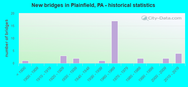
- New bridges - historical statistics
- 1Before 1900
- 31920-1929
- 21930-1939
- 11950-1959
- 171960-1969
- 21980-1989
- 22000-2009
- 42010-2019

- Reconstructed bridges - Historical Statistics
- 21970-1979
- 01980-1989
- 01990-1999
- 22000-2009
- 02010-2019
- 12020-2022


- Bridge Condition - Deck
- 4.3%Excellent
- 13.0%Very good
- 17.4%Good
- 26.1%Satisfactory
- 30.4%Fair
- 8.7%Poor

- Bridge Condition - Superstructure
- 4.3%Excellent
- 26.1%Very good
- 13.0%Good
- 8.7%Satisfactory
- 34.8%Fair
- 8.7%Poor
- 4.3%Critical

- Bridge Condition - Substructure
- 39.1%Good
- 26.1%Satisfactory
- 34.8%Fair

- Bridge Condition - Channel
- 10.0%Very good
- 20.0%Good
- 10.0%Satisfactory
- 60.0%Fair
Find on map >> Show street view
Structure Number: 8641, Location: FRANKLIN BOROUGH (Lat: 40.346200, Lng: -78.880206), Route carried "on" structure: State highway , Year Built: 1928, Year Reconstructed: 1978, Status: Open, Structure Length: 0.85m (2.79ft), Average Daily Traffic: 846 (year 2020), Truck Traffic: 3%, Average Future Daily Traffic: 1,206 (year 2032), Design Load: H 20, Features Intersected: CLAPBOARD RUN, Facility Carried by Structure: SR 3026
Minimum Vertical Clearance: 30+ m (98+ ft), Kilometerpoint: 0.576, Lanes on structure: 2, Owner: State Highway Agency, Approaching Roadway Width: 8.5m (27.9ft), Skew: 2 degrees, Material/Design: Concrete, Design/Construction: Tee Beam, Number Of Spans In Main Unit: 1, Length of Maximum Span: 7.9m (25.9ft), Curb or Sidewalk Widths: Left: 1.3m (4.3ft), Right: 0.2m (0.7ft), Curb-To-Curb Width: 8.1m (26.6ft), Out-to-Out Width: 10.4m (34.1ft)
Condition: Deck: Fair, Superstructure: Fair, Substructure: Fair, Channel: Very good, Operating Rating: 50.8 metric tons, Method Used To Determine Operating Rating: Load Factor (LF), Inventory Rating: 30.8 metric tons, Method Used To Determine Inventory Rating: Load Factor (LF), Structural Evaluation: Somewhat better than minimum adequacy, Deck Geometry: Somewhat better than minimum adequacy, Waterway Adequacy: Equal to present desirable criteria, Approach Roadway Alignment: Equal to present minimum criteria, Length Of Structure Improvement: 1.10m (3.61ft), Designated Inspection Frequency: Every 24 months, Inspection Date: Febuary 2021, Bridge Improvement Cost: $43,000, Roadway Improvement Cost: $243,000, Total Project Cost: $575,000, Deck Structure Type: Concrete Cast-file-Place, Wearing Surface/Protective System: Wearing Surface: Bituminous
Find on map >> Show street view
Structure Number: 8644, Location: MINERAL POINT (Lat: 40.380092, Lng: -78.836853), Route carried "on" structure: State highway , Year Built: 1925, Year Reconstructed: 1976, Status: Open, Structure Length: 1.13m (3.71ft), Average Daily Traffic: 741 (year 2022), Truck Traffic: 6%, Average Future Daily Traffic: 1,072 (year 2032), Design Load: HS 20, Features Intersected: SALT LICK RUN, Facility Carried by Structure: SR 3030
Minimum Vertical Clearance: 30+ m (98+ ft), Kilometerpoint: 1.754, Lanes on structure: 2, Owner: State Highway Agency, Approaching Roadway Width: 7.3m (24.0ft), Material/Design: Steel, Design/Construction: Stringer/Multi-beam, Number Of Spans In Main Unit: 1, Length of Maximum Span: 11.0m (36.1ft), Curb or Sidewalk Widths: Left: 0.2m (0.7ft), Right: 0.2m (0.7ft), Curb-To-Curb Width: 7.3m (24.0ft), Out-to-Out Width: 8.4m (27.6ft)
Condition: Deck: Satisfactory, Superstructure: Good, Substructure: Good, Channel: Good, Operating Rating: 63.5 metric tons, Method Used To Determine Operating Rating: Load Factor (LF), Inventory Rating: 38.1 metric tons, Method Used To Determine Inventory Rating: Load Factor (LF), Structural Evaluation: Better than present minimum criteria, Deck Geometry: Meets minimum limits, Waterway Adequacy: Equal to present desirable criteria, Approach Roadway Alignment: Equal to present desirable criteria, Length Of Structure Improvement: 1.90m (6.23ft), Designated Inspection Frequency: Every 24 months, Inspection Date: Febuary 2021, Deck Structure Type: Concrete Cast-file-Place, Wearing Surface/Protective System: Wearing Surface: Monolithic Concrete, Deck Protection: Galvanized Reinforcing
Find on map >> Show street view
Structure Number: 13653, Location: 6 MI.S. CARLISLE (Lat: 40.148381, Lng: -77.313164), Route carried "on" structure: Interstate 81, Year Built: 1963, Status: Open, Structure Length: 4.05m (13.29ft), Average Daily Traffic: 34,704 (year 2020), Truck Traffic: 26%, Average Future Daily Traffic: 28,129 (year 2032), Design Load: HS 20, Features Intersected: SR 3015; MT. ROCK RD.
Minimum Vertical Clearance: 30+ m (98+ ft), Kilometerpoint: 21.279, Lanes on structure: 2, Lanes under structure: 2, Base Highway Network: Yes, Owner: State Highway Agency, Approaching Roadway Width: 12.2m (40.0ft), Skew: 13 degrees, Material/Design: Prestressed concrete, Design/Construction: Box Beam or Girders - Single/Spread, Number Of Spans In Main Unit: 3, Length of Maximum Span: 13.1m (43.0ft), Curb or Sidewalk Widths: Left: 0.2m (0.7ft), Right: 0.2m (0.7ft), Curb-To-Curb Width: 12.3m (40.4ft), Out-to-Out Width: 13.9m (45.6ft)
Condition: Deck: Satisfactory, Superstructure: Fair, Substructure: Fair, Operating Rating: 86.2 metric tons, Method Used To Determine Operating Rating: Load Factor (LF), Inventory Rating: 34.5 metric tons, Method Used To Determine Inventory Rating: Load Factor (LF), Structural Evaluation: Somewhat better than minimum adequacy, Deck Geometry: Better than present minimum criteria, Underclear: High priority of corrective action, Approach Roadway Alignment: Equal to present desirable criteria, Length Of Structure Improvement: 4.80m (15.75ft), Designated Inspection Frequency: Every 24 months, Inspection Date: Febuary 2020, Bridge Improvement Cost: $31,000, Roadway Improvement Cost: $92,000, Total Project Cost: $421,000, Deck Structure Type: Concrete Cast-file-Place, Wearing Surface/Protective System: Wearing Surface: Bituminous, Membrane: Preformed Fabric
Find on map >> Show street view
Structure Number: 13654, Location: PENN TWP (Lat: 40.148706, Lng: -77.313044), Route carried "on" structure: Interstate 81, Year Built: 1963, Status: Open, Structure Length: 4.08m (13.39ft), Average Daily Traffic: 27,247 (year 2020), Truck Traffic: 28%, Average Future Daily Traffic: 28,207 (year 2032), Design Load: HS 20, Features Intersected: SR 3015; MT. ROCK RD.
Minimum Vertical Clearance: 30+ m (98+ ft), Kilometerpoint: 21.282, Lanes on structure: 2, Lanes under structure: 2, Base Highway Network: Yes, Owner: State Highway Agency, Approaching Roadway Width: 12.2m (40.0ft), Skew: 13 degrees, Material/Design: Prestressed concrete, Design/Construction: Box Beam or Girders - Single/Spread, Number Of Spans In Main Unit: 3, Length of Maximum Span: 13.7m (44.9ft), Curb or Sidewalk Widths: Left: 0.2m (0.7ft), Right: 0.2m (0.7ft), Curb-To-Curb Width: 12.3m (40.4ft), Out-to-Out Width: 13.9m (45.6ft)
Condition: Deck: Satisfactory, Superstructure: Fair, Substructure: Fair, Operating Rating: 86.2 metric tons, Method Used To Determine Operating Rating: Load Factor (LF), Inventory Rating: 34.5 metric tons, Method Used To Determine Inventory Rating: Load Factor (LF), Structural Evaluation: Somewhat better than minimum adequacy, Deck Geometry: Better than present minimum criteria, Underclear: Meets minimum limits, Approach Roadway Alignment: Equal to present desirable criteria, Length Of Structure Improvement: 4.80m (15.75ft), Designated Inspection Frequency: Every 24 months, Inspection Date: Febuary 2020, Bridge Improvement Cost: $31,000, Roadway Improvement Cost: $92,000, Total Project Cost: $421,000, Deck Structure Type: Concrete Cast-file-Place, Wearing Surface/Protective System: Wearing Surface: Bituminous, Membrane: Preformed Fabric
Find on map >> Show street view
Structure Number: 13655, Location: 5.5 MI.S. CARLISLE (Lat: 40.154064, Lng: -77.300858), Route carried "on" structure: Interstate 81, Year Built: 1963, Status: Open, Structure Length: 3.57m (11.71ft), Average Daily Traffic: 34,704 (year 2020), Truck Traffic: 26%, Average Future Daily Traffic: 28,129 (year 2032), Design Load: HS 20, Features Intersected: T-545; STONE HOUSE RD.
Minimum Vertical Clearance: 30+ m (98+ ft), Kilometerpoint: 22.880, Lanes on structure: 2, Lanes under structure: 2, Base Highway Network: Yes, Owner: State Highway Agency, Approaching Roadway Width: 12.5m (41.0ft), Skew: 11 degrees, Material/Design: Prestressed concrete, Design/Construction: Box Beam or Girders - Single/Spread, Number Of Spans In Main Unit: 3, Length of Maximum Span: 13.4m (44.0ft), Curb or Sidewalk Widths: Left: 0.2m (0.7ft), Right: 0.2m (0.7ft), Curb-To-Curb Width: 12.6m (41.3ft), Out-to-Out Width: 14.0m (45.9ft)
Condition: Deck: Fair, Superstructure: Fair, Substructure: Fair, Operating Rating: 71.7 metric tons, Method Used To Determine Operating Rating: Load Factor (LF), Inventory Rating: 28.1 metric tons, Method Used To Determine Inventory Rating: Load Factor (LF), Structural Evaluation: Somewhat better than minimum adequacy, Deck Geometry: Better than present minimum criteria, Underclear: Equal to present minimum criteria, Approach Roadway Alignment: Equal to present desirable criteria, Length Of Structure Improvement: 4.40m (14.44ft), Designated Inspection Frequency: Every 24 months, Inspection Date: Febuary 2020, Bridge Improvement Cost: $29,000, Roadway Improvement Cost: $86,000, Total Project Cost: $394,000, Deck Structure Type: Concrete Cast-file-Place, Wearing Surface/Protective System: Wearing Surface: Bituminous
Find on map >> Show street view
Structure Number: 13656, Location: 5.5 MI.S. OF CARLISLE (Lat: 40.154300, Lng: -77.300956), Route carried "on" structure: Interstate 81, Year Built: 1963, Status: Open, Structure Length: 3.60m (11.81ft), Average Daily Traffic: 27,247 (year 2020), Truck Traffic: 28%, Average Future Daily Traffic: 28,207 (year 2032), Design Load: HS 20, Features Intersected: T-545; STONE HOUSE RD.
Minimum Vertical Clearance: 30+ m (98+ ft), Kilometerpoint: 22.877, Lanes on structure: 2, Lanes under structure: 2, Base Highway Network: Yes, Owner: State Highway Agency, Approaching Roadway Width: 12.5m (41.0ft), Skew: 11 degrees, Material/Design: Prestressed concrete, Design/Construction: Box Beam or Girders - Single/Spread, Number Of Spans In Main Unit: 3, Length of Maximum Span: 13.4m (44.0ft), Curb or Sidewalk Widths: Left: 0.2m (0.7ft), Right: 0.2m (0.7ft), Curb-To-Curb Width: 12.6m (41.3ft), Out-to-Out Width: 14.0m (45.9ft)
Condition: Deck: Fair, Superstructure: Fair, Substructure: Fair, Operating Rating: 56.2 metric tons, Method Used To Determine Operating Rating: Load Factor (LF), Inventory Rating: 29.9 metric tons, Method Used To Determine Inventory Rating: Load Factor (LF), Structural Evaluation: Somewhat better than minimum adequacy, Deck Geometry: Better than present minimum criteria, Underclear: Somewhat better than minimum adequacy, Approach Roadway Alignment: Equal to present desirable criteria, Length Of Structure Improvement: 4.40m (14.44ft), Designated Inspection Frequency: Every 24 months, Inspection Date: Febuary 2020, Bridge Improvement Cost: $47,000, Roadway Improvement Cost: $138,000, Total Project Cost: $632,000, Deck Structure Type: Concrete Cast-file-Place, Wearing Surface/Protective System: Wearing Surface: Bituminous
Find on map >> Show street view
Structure Number: 13657, Location: 5 MI.S. CARLISLE (Lat: 40.160231, Lng: -77.291653), Route carried "on" structure: Interstate 81, Year Built: 1963, Status: Open, Structure Length: 1.13m (3.71ft), Average Daily Traffic: 34,704 (year 2020), Truck Traffic: 26%, Average Future Daily Traffic: 28,129 (year 2032), Design Load: HS 20, Features Intersected: MOOREDALE RD.; T-466
Minimum Vertical Clearance: 30+ m (98+ ft), Kilometerpoint: 23.646, Lanes on structure: 2, Lanes under structure: 2, Base Highway Network: Yes, Owner: State Highway Agency, Approaching Roadway Width: 12.2m (40.0ft), Skew: 12 degrees, Material/Design: Prestressed concrete, Design/Construction: Box Beam or Girders - Single/Spread, Number Of Spans In Main Unit: 1, Length of Maximum Span: 10.7m (35.1ft), Curb or Sidewalk Widths: Left: 0.2m (0.7ft), Right: 0.2m (0.7ft), Curb-To-Curb Width: 12.5m (41.0ft), Out-to-Out Width: 14.0m (45.9ft)
Condition: Deck: Satisfactory, Superstructure: Satisfactory, Substructure: Satisfactory, Operating Rating: 53.5 metric tons, Method Used To Determine Operating Rating: Load Factor (LF), Inventory Rating: 26.3 metric tons, Method Used To Determine Inventory Rating: Load Factor (LF), Structural Evaluation: Equal to present minimum criteria, Deck Geometry: Better than present minimum criteria, Underclear: Equal to present minimum criteria, Approach Roadway Alignment: Equal to present desirable criteria, Length Of Structure Improvement: 1.70m (5.58ft), Designated Inspection Frequency: Every 24 months, Inspection Date: November 2019, Deck Structure Type: Concrete Cast-file-Place, Wearing Surface/Protective System: Wearing Surface: Bituminous, Membrane: Preformed Fabric
Find on map >> Show street view
Structure Number: 13658, Location: 5 MI.S. OF CARLISLE (Lat: 40.160469, Lng: -77.291717), Route carried "on" structure: Interstate 81, Year Built: 1963, Status: Open, Structure Length: 1.07m (3.51ft), Average Daily Traffic: 27,247 (year 2020), Truck Traffic: 28%, Average Future Daily Traffic: 28,207 (year 2032), Design Load: HS 20, Features Intersected: MOOREDALE RD.; T-466
Minimum Vertical Clearance: 30+ m (98+ ft), Kilometerpoint: 23.635, Lanes on structure: 2, Lanes under structure: 2, Base Highway Network: Yes, Owner: State Highway Agency, Approaching Roadway Width: 12.2m (40.0ft), Skew: 12 degrees, Material/Design: Prestressed concrete, Design/Construction: Box Beam or Girders - Single/Spread, Number Of Spans In Main Unit: 1, Length of Maximum Span: 10.7m (35.1ft), Curb or Sidewalk Widths: Left: 0.2m (0.7ft), Right: 0.2m (0.7ft), Curb-To-Curb Width: 12.5m (41.0ft), Out-to-Out Width: 14.0m (45.9ft)
Condition: Deck: Satisfactory, Superstructure: Satisfactory, Substructure: Satisfactory, Operating Rating: 55.3 metric tons, Method Used To Determine Operating Rating: Load Factor (LF), Inventory Rating: 29.0 metric tons, Method Used To Determine Inventory Rating: Load Factor (LF), Structural Evaluation: Equal to present minimum criteria, Deck Geometry: Better than present minimum criteria, Underclear: Superior to present desirable criteria, Approach Roadway Alignment: Equal to present desirable criteria, Length Of Structure Improvement: 1.70m (5.58ft), Designated Inspection Frequency: Every 24 months, Inspection Date: November 2019, Deck Structure Type: Concrete Cast-file-Place, Wearing Surface/Protective System: Wearing Surface: Bituminous
Find on map >> Show street view
Structure Number: 1366, Location: 4 MI.S. OF CARLISLE (Lat: 40.167514, Lng: -77.276258), Route carried "on" structure: Interstate 81, Year Built: 1963, Status: Open, Structure Length: 1.07m (3.51ft), Average Daily Traffic: 27,247 (year 2020), Truck Traffic: 28%, Average Future Daily Traffic: 28,207 (year 2032), Design Load: HS 20, Features Intersected: BURNT HOUSE RD.; T-451
Minimum Vertical Clearance: 30+ m (98+ ft), Kilometerpoint: 25.309, Lanes on structure: 2, Lanes under structure: 2, Base Highway Network: Yes, Owner: State Highway Agency, Approaching Roadway Width: 12.2m (40.0ft), Skew: 10 degrees, Material/Design: Prestressed concrete, Design/Construction: Box Beam or Girders - Single/Spread, Number Of Spans In Main Unit: 1, Length of Maximum Span: 10.1m (33.1ft), Curb or Sidewalk Widths: Left: 0.2m (0.7ft), Right: 0.2m (0.7ft), Curb-To-Curb Width: 12.4m (40.7ft), Out-to-Out Width: 13.9m (45.6ft)
Condition: Deck: Satisfactory, Superstructure: Good, Substructure: Fair, Operating Rating: 62.6 metric tons, Method Used To Determine Operating Rating: Load Factor (LF), Inventory Rating: 24.5 metric tons, Method Used To Determine Inventory Rating: Load Factor (LF), Structural Evaluation: Somewhat better than minimum adequacy, Deck Geometry: Better than present minimum criteria, Underclear: Equal to present minimum criteria, Approach Roadway Alignment: Equal to present desirable criteria, Length Of Structure Improvement: 1.60m (5.25ft), Designated Inspection Frequency: Every 24 months, Inspection Date: March 2020, Bridge Improvement Cost: $20,000, Roadway Improvement Cost: $59,000, Total Project Cost: $270,000, Deck Structure Type: Concrete Cast-file-Place, Wearing Surface/Protective System: Wearing Surface: Bituminous
Find on map >> Show street view
Structure Number: 13794, Location: Bloserville (Lat: 40.246647, Lng: -77.333592), Route carried "on" structure: State highway 944, Year Built: 1957, Year Reconstructed: 2020, Status: Open, Structure Length: 1.25m (4.10ft), Average Daily Traffic: 973 (year 2022), Truck Traffic: 13%, Average Future Daily Traffic: 1,202 (year 2032), Design Load: HL 93, Features Intersected: Locust Creek
Minimum Vertical Clearance: 30+ m (98+ ft), Kilometerpoint: 10.509, Lanes on structure: 2, Owner: State Highway Agency, Approaching Roadway Width: 7.9m (25.9ft), Skew: 4 degrees, Material/Design: Prestressed concrete, Design/Construction: Box Beam or Girders - Single/Spread, Number Of Spans In Main Unit: 1, Length of Maximum Span: 11.9m (39.0ft), Curb-To-Curb Width: 8.2m (26.9ft), Out-to-Out Width: 9.1m (29.9ft)
Condition: Deck: Excellent, Superstructure: Excellent, Substructure: Satisfactory, Channel: Satisfactory, Operating Rating: 83.5 metric tons, Method Used To Determine Operating Rating: Load Factor (LF), Inventory Rating: 42.6 metric tons, Method Used To Determine Inventory Rating: Load Factor (LF), Structural Evaluation: Equal to present minimum criteria, Deck Geometry: Somewhat better than minimum adequacy, Waterway Adequacy: Better than present minimum criteria, Approach Roadway Alignment: Somewhat better than minimum adequacy, Length Of Structure Improvement: 1.90m (6.23ft), Designated Inspection Frequency: Every 24 months, Inspection Date: December 2020, Bridge Improvement Cost: $8,000, Roadway Improvement Cost: $24,000, Total Project Cost: $110,000, Deck Structure Type: Concrete Cast-file-Place, Wearing Surface/Protective System: Wearing Surface: Monolithic Concrete, Deck Protection: Epoxy Coated Reinforcing
Find on map >> Show street view
Structure Number: 13997, Location: WEST PENNSBORO TWP (Lat: 40.203333, Lng: -77.323333), Route carried "on" structure: City street T448, Year Built: 1939, Year Reconstructed: 2006, Status: Open, Structure Length: 3.81m (12.50ft), Average Daily Traffic: 200 (year 1992), Truck Traffic: 6%, Average Future Daily Traffic: 315 (year 2030), Design Load: HL 93, Features Intersected: PA TPK (I-76), Facility Carried by Structure: T-448
Minimum Vertical Clearance: 30+ m (98+ ft), Kilometerpoint: 0.000, Lanes on structure: 2, Lanes under structure: 6, Owner: State Toll Authority, Approaching Roadway Width: 9.8m (32.2ft), Material/Design: Prestressed concrete continuous, Design/Construction: Box Beam or Girders - Single/Spread, Number Of Spans In Main Unit: 2, Length of Maximum Span: 18.9m (62.0ft), Curb or Sidewalk Widths: Left: 0.2m (0.7ft), Right: 0.2m (0.7ft), Curb-To-Curb Width: 9.8m (32.2ft), Out-to-Out Width: 10.8m (35.4ft)
Condition: Deck: Very good, Superstructure: Good, Substructure: Good, Operating Rating: 70.8 metric tons, Method Used To Determine Operating Rating: Load and Resistance Factor (LRFR), Inventory Rating: 51.7 metric tons, Method Used To Determine Inventory Rating: Load and Resistance Factor (LRFR), Structural Evaluation: Better than present minimum criteria, Deck Geometry: Better than present minimum criteria, Underclear: Better than present minimum criteria, Approach Roadway Alignment: Better than present minimum criteria, Length Of Structure Improvement: 3.50m (11.48ft), Designated Inspection Frequency: Every 48 months, Inspection Date: January 2019, Bridge Improvement Cost: $6,000, Roadway Improvement Cost: $17,000, Total Project Cost: $78,000, Deck Structure Type: Concrete Cast-file-Place, Wearing Surface/Protective System: Wearing Surface: Monolithic Concrete, Deck Protection: Epoxy Coated Reinforcing
Find on map >> Show street view
Structure Number: 14001, Location: WEST PENNSBORO TWP (Lat: 40.203333, Lng: -77.283333), Route carried "on" structure: City street , Year Built: 1939, Year Reconstructed: 2005, Status: Open, Structure Length: 5.39m (17.68ft), Average Daily Traffic: 200 (year 1992), Truck Traffic: 6%, Average Future Daily Traffic: 315 (year 2030), Design Load: HS 25 or greater, Features Intersected: PA TPK (I-76), Facility Carried by Structure: T-457
Minimum Vertical Clearance: 30+ m (98+ ft), Kilometerpoint: 0.000, Lanes on structure: 2, Lanes under structure: 4, Owner: State Toll Authority, Approaching Roadway Width: 9.8m (32.2ft), Skew: 3 degrees, Material/Design: Prestressed concrete continuous, Design/Construction: Box Beam or Girders - Single/Spread, Number Of Spans In Main Unit: 2, Length of Maximum Span: 30.2m (99.1ft), Curb or Sidewalk Widths: Left: 0.2m (0.7ft), Right: 0.2m (0.7ft), Curb-To-Curb Width: 9.8m (32.2ft), Out-to-Out Width: 10.8m (35.4ft)
Condition: Deck: Very good, Superstructure: Very good, Substructure: Good, Operating Rating: 78.9 metric tons, Method Used To Determine Operating Rating: Load and Resistance Factor (LRFR), Inventory Rating: 60.8 metric tons, Method Used To Determine Inventory Rating: Load and Resistance Factor (LRFR), Structural Evaluation: Better than present minimum criteria, Deck Geometry: Better than present minimum criteria, Underclear: Better than present minimum criteria, Approach Roadway Alignment: Better than present minimum criteria, Length Of Structure Improvement: 4.10m (13.45ft), Designated Inspection Frequency: Every 48 months, Inspection Date: January 2019, Bridge Improvement Cost: $28,000, Roadway Improvement Cost: $83,000, Total Project Cost: $379,000, Deck Structure Type: Concrete Cast-file-Place, Wearing Surface/Protective System: Wearing Surface: Monolithic Concrete, Deck Protection: Epoxy Coated Reinforcing
Find on map >> Show street view
Structure Number: 14064, Location: 3 W CRLSLE/L.FRK/W.PNBR (Lat: 40.221331, Lng: -77.258719), Route carried "on" structure: City street , Year Built: 1896, Status: Closed, Structure Length: 6.64m (21.78ft), Average Daily Traffic: 439 (year 2019), Truck Traffic: 1%, Average Future Daily Traffic: 503 (year 2039), Features Intersected: CONODOGUINET CREEK, Facility Carried by Structure: CREEK RD., T-427
Minimum Vertical Clearance: 5.79m (19.00ft), Kilometerpoint: 0.000, Lanes on structure: 1, Owner: County Highway Agency, Approaching Roadway Width: 6.7m (22.0ft), Material/Design: Aluminum, Iron, Design/Construction: Truss - Thru, Number Of Spans In Main Unit: 1, Length of Maximum Span: 65.8m (215.9ft), Curb-To-Curb Width: 4.5m (14.8ft), Out-to-Out Width: 4.8m (15.7ft)
Condition: Deck: Fair, Superstructure: Critical, Substructure: Fair, Channel: Fair, Operating Rating: 12.7 metric tons, Method Used To Determine Operating Rating: Allowable Stress (AS), Inventory Rating: 5.4 metric tons, Method Used To Determine Inventory Rating: Allowable Stress (AS), Waterway Adequacy: Equal to present minimum criteria, Approach Roadway Alignment: Meets minimum limits, Bridge Posting: Required (Relationship of Operating Rating to Maximum Legal Load: > 39.9% below), Length Of Structure Improvement: 8.30m (27.23ft), Designated Inspection Frequency: Every 24 months, Critical Feature Inspection Frequency: Every 24 months, Inspection Date: July 2021, Critical Feature Inspection Date: July 2021, Bridge Improvement Cost: $108,000, Roadway Improvement Cost: $319,000, Total Project Cost: $1,461,000, Deck Structure Type: Open Grating
Find on map >> Show street view
Structure Number: 14065, Location: 5NE NWVLLE/CONDOGUINET (Lat: 40.231503, Lng: -77.336356), Route carried "on" structure: City street , Year Built: 1962, Status: Open, Structure Length: 5.94m (19.49ft), Average Daily Traffic: 292 (year 2019), Truck Traffic: 1%, Average Future Daily Traffic: 334 (year 2039), Design Load: H 20, Features Intersected: CONODOGUINET CREEK, Facility Carried by Structure: STANTON BR. T-448
Minimum Vertical Clearance: 30+ m (98+ ft), Kilometerpoint: 0.000, Lanes on structure: 2, Owner: County Highway Agency, Approaching Roadway Width: 5.8m (19.0ft), Skew: 3 degrees, Material/Design: Prestressed concrete, Design/Construction: Box Beam or Girders - Multiple, Number Of Spans In Main Unit: 3, Length of Maximum Span: 19.5m (64.0ft), Curb or Sidewalk Widths: Left: 0.5m (1.6ft), Right: 0.5m (1.6ft), Curb-To-Curb Width: 6.1m (20.0ft), Out-to-Out Width: 7.8m (25.6ft)
Condition: Deck: Fair, Superstructure: Fair, Substructure: Satisfactory, Channel: Fair, Operating Rating: 70.8 metric tons, Method Used To Determine Operating Rating: Load Factor (LF), Inventory Rating: 24.5 metric tons, Method Used To Determine Inventory Rating: Load Factor (LF), Structural Evaluation: Somewhat better than minimum adequacy, Deck Geometry: Meets minimum limits, Waterway Adequacy: Better than present minimum criteria, Approach Roadway Alignment: Somewhat better than minimum adequacy, Length Of Structure Improvement: 6.90m (22.64ft), Designated Inspection Frequency: Every 24 months, Inspection Date: June 2021, Deck Structure Type: Concrete Cast-file-Place, Wearing Surface/Protective System: Wearing Surface: Monolithic Concrete
Find on map >> Show street view
Structure Number: 14067, Location: 1.2 NE PLAINFIELD/CONODOG (Lat: 40.211850, Lng: -77.272783), Route carried "on" structure: City street , Year Built: 1960, Status: Open, Structure Length: 7.47m (24.51ft), Average Daily Traffic: 1,167 (year 2021), Truck Traffic: 1%, Average Future Daily Traffic: 1,336 (year 2041), Design Load: H 20, Features Intersected: CONODOGUINET CREEK, Facility Carried by Structure: BURGNER RD., T-457
Minimum Vertical Clearance: 30+ m (98+ ft), Kilometerpoint: 0.000, Lanes on structure: 2, Owner: County Highway Agency, Approaching Roadway Width: 6.1m (20.0ft), Material/Design: Prestressed concrete, Design/Construction: Box Beam or Girders - Multiple, Number Of Spans In Main Unit: 4, Length of Maximum Span: 18.6m (61.0ft), Curb-To-Curb Width: 5.9m (19.4ft), Out-to-Out Width: 6.5m (21.3ft)
Condition: Deck: Poor, Superstructure: Poor, Substructure: Fair, Channel: Fair, Operating Rating: 59.9 metric tons, Method Used To Determine Operating Rating: Load Factor (LF), Inventory Rating: 28.1 metric tons, Method Used To Determine Inventory Rating: Load Factor (LF), Structural Evaluation: Meets minimum limits, Deck Geometry: High priority of replacement, Waterway Adequacy: Superior to present desirable criteria, Approach Roadway Alignment: Equal to present desirable criteria, Length Of Structure Improvement: 8.40m (27.56ft), Designated Inspection Frequency: Every 24 months, Inspection Date: August 2021, Bridge Improvement Cost: $13,000, Roadway Improvement Cost: $39,000, Total Project Cost: $178,000, Deck Structure Type: Other, Wearing Surface/Protective System: Wearing Surface: Bituminous
Find on map >> Show street view
Structure Number: 14068, Location: @ SPILLWAY OF OPPOSOM LAK (Lat: 40.224492, Lng: -77.273792), Route carried "on" structure: City street , Year Built: 1929, Status: Open, Structure Length: 1.04m (3.41ft), Average Daily Traffic: 100 (year 2021), Average Future Daily Traffic: 140 (year 2041), Features Intersected: OPPOSSUM CREEK, Facility Carried by Structure: OPOSSOM ROAD, T460
Minimum Vertical Clearance: 30+ m (98+ ft), Kilometerpoint: 0.000, Lanes on structure: 2, Owner: Town or Township Highway Agency, Approaching Roadway Width: 5.2m (17.1ft), Skew: 1 degrees, Material/Design: Concrete continuous, Design/Construction: Stringer/Multi-beam, Number Of Spans In Main Unit: 1, Length of Maximum Span: 9.8m (32.2ft), Curb-To-Curb Width: 5.4m (17.7ft), Out-to-Out Width: 6.0m (19.7ft)
Condition: Deck: Fair, Superstructure: Fair, Substructure: Satisfactory, Channel: Fair, Operating Rating: 32.7 metric tons, Method Used To Determine Operating Rating: Field evaluation and documented engineering judgment, Inventory Rating: 26.3 metric tons, Method Used To Determine Inventory Rating: Field evaluation and documented engineering judgment, Structural Evaluation: Somewhat better than minimum adequacy, Deck Geometry: High priority of corrective action, Waterway Adequacy: Better than present minimum criteria, Approach Roadway Alignment: Better than present minimum criteria, Length Of Structure Improvement: 1.70m (5.58ft), Designated Inspection Frequency: Every 24 months, Inspection Date: July 2021, Bridge Improvement Cost: $3,000, Roadway Improvement Cost: $7,000, Total Project Cost: $35,000, Deck Structure Type: Concrete Cast-file-Place, Wearing Surface/Protective System: Wearing Surface: Bituminous
Find on map >> Show street view
Structure Number: 40691, Location: T449/T454 INTERSECTION (Lat: 40.241586, Lng: -77.319294), Route carried "on" structure: City street , Year Built: 1989, Status: Posted for load, Structure Length: 0.67m (2.20ft), Average Daily Traffic: 100 (year 2021), Average Future Daily Traffic: 140 (year 2041), Design Load: HS 20, Features Intersected: LOCUST CREEK, Facility Carried by Structure: T-449
Minimum Vertical Clearance: 30+ m (98+ ft), Kilometerpoint: 0.000, Lanes on structure: 2, Owner: Town or Township Highway Agency, Approaching Roadway Width: 5.5m (18.0ft), Material/Design: Prestressed concrete, Design/Construction: Slab, Number Of Spans In Main Unit: 1, Length of Maximum Span: 6.4m (21.0ft), Curb-To-Curb Width: 8.1m (26.6ft), Out-to-Out Width: 8.6m (28.2ft)
Condition: Deck: Poor, Superstructure: Poor, Substructure: Good, Channel: Fair, Operating Rating: 26.3 metric tons, Method Used To Determine Operating Rating: Load Factor (LF), Inventory Rating: 10.9 metric tons, Method Used To Determine Inventory Rating: Load Factor (LF), Structural Evaluation: Meets minimum limits, Deck Geometry: Equal to present minimum criteria, Waterway Adequacy: Better than present minimum criteria, Approach Roadway Alignment: Equal to present desirable criteria, Bridge Posting: Required (Relationship of Operating Rating to Maximum Legal Load: > 39.9% below), Length Of Structure Improvement: 1.30m (4.27ft), Designated Inspection Frequency: Every 24 months, Other Special Inspection Frequency: Every 12 months, Inspection Date: July 2021, Other Special Inspection Date: July 2021, Wearing Surface/Protective System: Wearing Surface: Bituminous
Find on map >> Show street view
Structure Number: 40692, Location: T454 BETWEEN T453 & T449 (Lat: 40.236136, Lng: -77.317328), Route carried "on" structure: City street , Year Built: 1989, Status: Posted for load, Structure Length: 0.76m (2.49ft), Average Daily Traffic: 100 (year 2021), Truck Traffic: 3%, Average Future Daily Traffic: 140 (year 2041), Design Load: HS 20, Features Intersected: LOCUST CREEK, Facility Carried by Structure: T-454
Minimum Vertical Clearance: 30+ m (98+ ft), Kilometerpoint: 0.000, Lanes on structure: 2, Owner: Town or Township Highway Agency, Approaching Roadway Width: 6.7m (22.0ft), Skew: 1 degrees, Material/Design: Prestressed concrete, Design/Construction: Slab, Number Of Spans In Main Unit: 1, Length of Maximum Span: 7.3m (24.0ft), Curb-To-Curb Width: 8.2m (26.9ft), Out-to-Out Width: 8.6m (28.2ft)
Condition: Deck: Fair, Superstructure: Fair, Substructure: Satisfactory, Channel: Fair, Operating Rating: 35.4 metric tons, Method Used To Determine Operating Rating: Load Factor (LF), Inventory Rating: 13.6 metric tons, Method Used To Determine Inventory Rating: Load Factor (LF), Structural Evaluation: Meets minimum limits, Deck Geometry: Equal to present minimum criteria, Waterway Adequacy: Better than present minimum criteria, Approach Roadway Alignment: Equal to present desirable criteria, Bridge Posting: Required (Relationship of Operating Rating to Maximum Legal Load: 20.0 - 29.9% below), Length Of Structure Improvement: 1.50m (4.92ft), Designated Inspection Frequency: Every 24 months, Other Special Inspection Frequency: Every 12 months, Inspection Date: July 2021, Other Special Inspection Date: July 2021, Wearing Surface/Protective System: Wearing Surface: Bituminous
Find on map >> Show street view
Structure Number: 456, Location: 2.5 M. S. OF BLOSERVILLE (Lat: 40.203858, Lng: -77.347394), Route carried "on" structure: State highway , Year Built: 2009, Status: Open, Structure Length: 4.97m (16.31ft), Average Daily Traffic: 1,534 (year 2020), Truck Traffic: 6%, Average Future Daily Traffic: 2,374 (year 2032), Design Load: HL 93, Features Intersected: I-76 PA TPK MP (215.96), Facility Carried by Structure: SR4021 BLOSERVILLE
Minimum Vertical Clearance: 30+ m (98+ ft), Kilometerpoint: 0.853, Lanes on structure: 2, Lanes under structure: 4, Owner: State Highway Agency, Approaching Roadway Width: 9.8m (32.2ft), Skew: 3 degrees, Material/Design: Prestressed concrete continuous, Design/Construction: Box Beam or Girders - Single/Spread, Number Of Spans In Main Unit: 2, Length of Maximum Span: 24.4m (80.1ft), Curb-To-Curb Width: 9.8m (32.2ft), Out-to-Out Width: 10.9m (35.8ft)
Condition: Deck: Good, Superstructure: Very good, Substructure: Good, Operating Rating: 88.0 metric tons, Method Used To Determine Operating Rating: Load and Resistance Factor (LRFR), Inventory Rating: 42.6 metric tons, Method Used To Determine Inventory Rating: Load and Resistance Factor (LRFR), Structural Evaluation: Better than present minimum criteria, Deck Geometry: Somewhat better than minimum adequacy, Underclear: Equal to present minimum criteria, Approach Roadway Alignment: Better than present minimum criteria, Designated Inspection Frequency: Every 24 months, Inspection Date: Febuary 2020, Deck Structure Type: Concrete Cast-file-Place, Wearing Surface/Protective System: Wearing Surface: Monolithic Concrete, Deck Protection: Epoxy Coated Reinforcing
Find on map >> Show street view
Structure Number: 46335, Location: WEST PENNSBORO TWP (Lat: 40.206178, Lng: -77.272536), Route carried "on" structure: City street T482, Year Built: 2010, Status: Open, Structure Length: 3.90m (12.80ft), Average Daily Traffic: 1,746 (year 2007), Truck Traffic: 6%, Average Future Daily Traffic: 2,298 (year 2030), Design Load: HL 93, Features Intersected: PA TPK (I-76), Facility Carried by Structure: T-482
Minimum Vertical Clearance: 30+ m (98+ ft), Kilometerpoint: 0.000, Lanes on structure: 2, Lanes under structure: 6, Owner: State Toll Authority, Approaching Roadway Width: 9.8m (32.2ft), Material/Design: Prestressed concrete continuous, Design/Construction: Box Beam or Girders - Single/Spread, Number Of Spans In Main Unit: 2, Length of Maximum Span: 19.2m (63.0ft), Curb or Sidewalk Widths: Left: 0.2m (0.7ft), Right: 0.2m (0.7ft), Curb-To-Curb Width: 9.8m (32.2ft), Out-to-Out Width: 10.8m (35.4ft)
Condition: Deck: Very good, Superstructure: Very good, Substructure: Good, Operating Rating: 71.7 metric tons, Method Used To Determine Operating Rating: Load and Resistance Factor (LRFR), Inventory Rating: 46.3 metric tons, Method Used To Determine Inventory Rating: Load and Resistance Factor (LRFR), Structural Evaluation: Better than present minimum criteria, Deck Geometry: Somewhat better than minimum adequacy, Underclear: Superior to present desirable criteria, Approach Roadway Alignment: Equal to present desirable criteria, Designated Inspection Frequency: Every 48 months, Inspection Date: January 2019, Deck Structure Type: Concrete Cast-file-Place, Wearing Surface/Protective System: Wearing Surface: Monolithic Concrete, Deck Protection: Epoxy Coated Reinforcing
Find on map >> Show street view
Structure Number: 46338, Location: west pennsboro twp. (Lat: 40.203333, Lng: -77.308333), Route carried "on" structure: City street T405, Year Built: 2010, Status: Open, Structure Length: 3.90m (12.80ft), Average Daily Traffic: 839 (year 2007), Truck Traffic: 6%, Average Future Daily Traffic: 1,104 (year 2030), Design Load: HL 93, Features Intersected: PA TPK (I-76), Facility Carried by Structure: T-405
Minimum Vertical Clearance: 30+ m (98+ ft), Kilometerpoint: 0.000, Lanes on structure: 2, Lanes under structure: 6, Owner: State Toll Authority, Approaching Roadway Width: 9.8m (32.2ft), Material/Design: Prestressed concrete continuous, Design/Construction: Box Beam or Girders - Single/Spread, Number Of Spans In Main Unit: 2, Length of Maximum Span: 19.2m (63.0ft), Curb or Sidewalk Widths: Left: 0.2m (0.7ft), Right: 0.2m (0.7ft), Curb-To-Curb Width: 9.8m (32.2ft), Out-to-Out Width: 10.8m (35.4ft)
Condition: Deck: Good, Superstructure: Very good, Substructure: Good, Operating Rating: 70.8 metric tons, Method Used To Determine Operating Rating: Load and Resistance Factor (LRFR), Inventory Rating: 43.5 metric tons, Method Used To Determine Inventory Rating: Load and Resistance Factor (LRFR), Structural Evaluation: Better than present minimum criteria, Deck Geometry: Equal to present minimum criteria, Underclear: Better than present minimum criteria, Approach Roadway Alignment: Better than present minimum criteria, Designated Inspection Frequency: Every 48 months, Inspection Date: January 2019, Deck Structure Type: Concrete Cast-file-Place, Wearing Surface/Protective System: Wearing Surface: Monolithic Concrete, Deck Protection: Epoxy Coated Reinforcing
Find on map >> Show street view
Structure Number: 47748, Location: West Pennsboro Twp. (Lat: 40.205089, Lng: -77.306628), Route carried "on" structure: Interstate 76, Year Built: 2012, Status: Open, Structure Length: 2.04m (6.69ft), Average Daily Traffic: 21,474 (year 2010), Truck Traffic: 31%, Average Future Daily Traffic: 22,983 (year 2030), Design Load: HL 93, Features Intersected: Mt. Rock Spring Creek
Minimum Vertical Clearance: 30+ m (98+ ft), Kilometerpoint: 0.000, Lanes on structure: 6, Base Highway Network: Yes, Toll: On toll road, Owner: State Toll Authority, Approaching Roadway Width: 35.1m (115.2ft), Skew: 30 degrees, Material/Design: Prestressed concrete, Design/Construction: Box Beam or Girders - Single/Spread, Number Of Spans In Main Unit: 1, Length of Maximum Span: 19.8m (65.0ft), Curb or Sidewalk Widths: Left: 0.2m (0.7ft), Right: 0.2m (0.7ft), Curb-To-Curb Width: 34.4m (112.9ft), Out-to-Out Width: 37.0m (121.4ft)
Condition: Deck: Good, Superstructure: Very good, Substructure: Good, Channel: Good, Operating Rating: 61.6 metric tons, Method Used To Determine Operating Rating: Assigned ratings based on Load and Resistance Factor Design (LRFD) reported by rating factor (RF) using HL93 loadings, Inventory Rating: 38.9 metric tons, Method Used To Determine Inventory Rating: Assigned ratings based on Load and Resistance Factor Design (LRFD) reported by rating factor (RF) using HL93 loadings, Structural Evaluation: Better than present minimum criteria, Deck Geometry: Superior to present desirable criteria, Waterway Adequacy: Superior to present desirable criteria, Approach Roadway Alignment: Equal to present desirable criteria, Designated Inspection Frequency: Every 24 months, Inspection Date: January 2021, Deck Structure Type: Concrete Cast-file-Place, Wearing Surface/Protective System: Wearing Surface: Monolithic Concrete, Deck Protection: Epoxy Coated Reinforcing
Find on map >> Show street view
Structure Number: 47749, Location: West Pennsboro Twp. (Lat: 40.205444, Lng: -77.295517), Route carried "on" structure: Interstate 76, Year Built: 2012, Status: Open, Structure Length: 1.58m (5.18ft), Average Daily Traffic: 21,474 (year 2010), Truck Traffic: 31%, Average Future Daily Traffic: 22,983 (year 2030), Design Load: HL 93, Features Intersected: T-456
Minimum Vertical Clearance: 30+ m (98+ ft), Kilometerpoint: 351.947, Lanes on structure: 6, Lanes under structure: 2, Base Highway Network: Yes, Toll: On toll road, Owner: State Toll Authority, Approaching Roadway Width: 36.0m (118.1ft), Skew: 30 degrees, Material/Design: Prestressed concrete, Design/Construction: Box Beam or Girders - Single/Spread, Number Of Spans In Main Unit: 1, Length of Maximum Span: 15.2m (49.9ft), Curb or Sidewalk Widths: Left: 0.2m (0.7ft), Right: 0.2m (0.7ft), Curb-To-Curb Width: 36.9m (121.1ft), Out-to-Out Width: 37.0m (121.4ft)
Condition: Deck: Good, Superstructure: Very good, Substructure: Good, Operating Rating: 56.1 metric tons, Method Used To Determine Operating Rating: Assigned ratings based on Load and Resistance Factor Design (LRFD) reported by rating factor (RF) using HL93 loadings, Inventory Rating: 35.3 metric tons, Method Used To Determine Inventory Rating: Assigned ratings based on Load and Resistance Factor Design (LRFD) reported by rating factor (RF) using HL93 loadings, Structural Evaluation: Better than present minimum criteria, Deck Geometry: Superior to present desirable criteria, Underclear: Meets minimum limits, Approach Roadway Alignment: Equal to present desirable criteria, Designated Inspection Frequency: Every 24 months, Inspection Date: January 2021, Deck Structure Type: Concrete Cast-file-Place, Wearing Surface/Protective System: Wearing Surface: Monolithic Concrete, Deck Protection: Epoxy Coated Reinforcing
Find on map >> Show street view
Structure Number: 13653, Location: 6 MI.S. CARLISLE (Lat: 40.148381, Lng: -77.313164), Route carried "under" structure: State highway , Year Built: 1963, Structure Length: 0. m, Average Daily Traffic: 310 (year 2022), Truck Traffic: 8%, Features Intersected: SR 3015; MT. ROCK RD., Facility Carried by Structure: I-81 NB; SR 0081
Minimum Vertical Clearance: 4.52m (14.83ft), Kilometerpoint: 2.979, Lanes on structure: 2, Lanes under structure: 2, Material/Design: Prestressed concrete, Design/Construction: Box Beam or Girders - Single/Spread, Length of Maximum Span: 13.1m (43.0ft)
Find on map >> Show street view
Structure Number: 13654, Location: PENN TWP (Lat: 40.148706, Lng: -77.313044), Route carried "under" structure: State highway , Year Built: 1963, Structure Length: 0. m, Average Daily Traffic: 310 (year 2022), Truck Traffic: 8%, Features Intersected: SR 3015; MT. ROCK RD., Facility Carried by Structure: I-81 SB; SR 0081
Minimum Vertical Clearance: 4.52m (14.83ft), Kilometerpoint: 2.979, Lanes on structure: 2, Lanes under structure: 2, Material/Design: Prestressed concrete, Design/Construction: Box Beam or Girders - Single/Spread, Length of Maximum Span: 13.7m (44.9ft)
Find on map >> Show street view
Structure Number: 13655, Location: 5.5 MI.S. CARLISLE (Lat: 40.154064, Lng: -77.300858), Route carried "under" structure: City street , Year Built: 1963, Structure Length: 0. m, Average Daily Traffic: 206 (year 1985), Truck Traffic: 2%, Features Intersected: T-545; STONE HOUSE RD., Facility Carried by Structure: I-81 NB; SR 0081
Minimum Vertical Clearance: 4.67m (15.32ft), Kilometerpoint: 0.000, Lanes on structure: 2, Lanes under structure: 2, Material/Design: Prestressed concrete, Design/Construction: Box Beam or Girders - Single/Spread, Length of Maximum Span: 13.4m (44.0ft)
Find on map >> Show street view
Structure Number: 13656, Location: 5.5 MI.S. OF CARLISLE (Lat: 40.154300, Lng: -77.300956), Route carried "under" structure: City street , Year Built: 1963, Structure Length: 0. m, Average Daily Traffic: 206 (year 1985), Truck Traffic: 2%, Features Intersected: T-545; STONE HOUSE RD., Facility Carried by Structure: I-81 SB; SR 0081
Minimum Vertical Clearance: 4.67m (15.32ft), Kilometerpoint: 0.000, Lanes on structure: 2, Lanes under structure: 2, Material/Design: Prestressed concrete, Design/Construction: Box Beam or Girders - Single/Spread, Length of Maximum Span: 13.4m (44.0ft)
Find on map >> Show street view
Structure Number: 13657, Location: 5 MI.S. CARLISLE (Lat: 40.160231, Lng: -77.291653), Route carried "under" structure: City street , Year Built: 1963, Structure Length: 0. m, Average Daily Traffic: 150 (year 1990), Truck Traffic: 5%, Features Intersected: MOOREDALE RD.; T-466, Facility Carried by Structure: I-81 NB; SR 0081
Minimum Vertical Clearance: 4.54m (14.90ft), Kilometerpoint: 0.000, Lanes on structure: 2, Lanes under structure: 2, Material/Design: Prestressed concrete, Design/Construction: Box Beam or Girders - Single/Spread, Length of Maximum Span: 10.7m (35.1ft)
Find on map >> Show street view
Structure Number: 13658, Location: 5 MI.S. OF CARLISLE (Lat: 40.160469, Lng: -77.291717), Route carried "under" structure: City street , Year Built: 1963, Structure Length: 0. m, Average Daily Traffic: 125 (year 1990), Truck Traffic: 5%, Features Intersected: MOOREDALE RD.; T-466, Facility Carried by Structure: I-81 SB; SR 0081
Minimum Vertical Clearance: 5.46m (17.91ft), Kilometerpoint: 0.000, Lanes on structure: 2, Lanes under structure: 2, Material/Design: Prestressed concrete, Design/Construction: Box Beam or Girders - Single/Spread, Length of Maximum Span: 10.7m (35.1ft)
Find on map >> Show street view
Structure Number: 13659, Location: 4 MI.S. OF CARLISLE (Lat: 40.167350, Lng: -77.276033), Route carried "under" structure: City street , Year Built: 1963, Structure Length: 0. m, Average Daily Traffic: 303 (year 1985), Truck Traffic: 2%, Features Intersected: BURNT HOUSE RD.; T-451, Facility Carried by Structure: I-81 NB; SR 0081
Minimum Vertical Clearance: 4.83m (15.85ft), Kilometerpoint: 0.000, Lanes on structure: 2, Lanes under structure: 2, Material/Design: Prestressed concrete, Design/Construction: Box Beam or Girders - Single/Spread, Length of Maximum Span: 10.1m (33.1ft)
Find on map >> Show street view
Structure Number: 1366, Location: 4 MI.S. OF CARLISLE (Lat: 40.167514, Lng: -77.276258), Route carried "under" structure: City street , Year Built: 1963, Structure Length: 0. m, Average Daily Traffic: 303 (year 1985), Truck Traffic: 2%, Features Intersected: BURNT HOUSE RD.; T-451, Facility Carried by Structure: I-81 SB; SR 0081
Minimum Vertical Clearance: 4.57m (14.99ft), Kilometerpoint: 0.000, Lanes on structure: 2, Lanes under structure: 2, Material/Design: Prestressed concrete, Design/Construction: Box Beam or Girders - Single/Spread, Length of Maximum Span: 10.1m (33.1ft)
Find on map >> Show street view
Structure Number: 456, Location: 2.5 M. S. OF BLOSERVILLE (Lat: 40.203858, Lng: -77.347394), Route carried "under" structure: Other road 76, Year Built: 2009, Structure Length: 0. m, Features Intersected: I-76 PA TPK MP (215.96), Facility Carried by Structure: SR4021 BLOSERVILLE
Minimum Vertical Clearance: 30+ m (98+ ft), Kilometerpoint: 347.554, Lanes on structure: 2, Lanes under structure: 4, Toll: On toll road, Material/Design: Prestressed concrete continuous, Design/Construction: Box Beam or Girders - Single/Spread, Length of Maximum Span: 24.4m (80.1ft)