Bridge Statistics for Pittsburg, California (CA)
Condition, Traffic, Stress, Structural Evaluation, Project Costs
- National Bridge Inventory (NBI) Statistics
- 40Number of bridges
- 354ft / 108mTotal length
- 1,138,948Total average daily traffic
- 68,097Total average daily truck traffic
- National Bridge Inventory (NBI) Registered Bridges for Pittsburg
- No street view available for this location
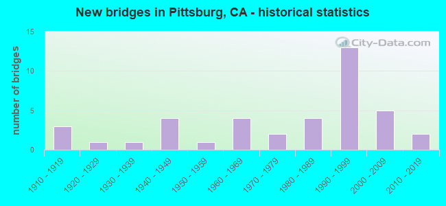
- New bridges - historical statistics
- 31910-1919
- 11920-1929
- 11930-1939
- 41940-1949
- 11950-1959
- 41960-1969
- 21970-1979
- 41980-1989
- 131990-1999
- 52000-2009
- 22010-2019
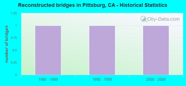
- Reconstructed bridges - Historical Statistics
- 11980-1989
- 11990-1999
- 12000-2009
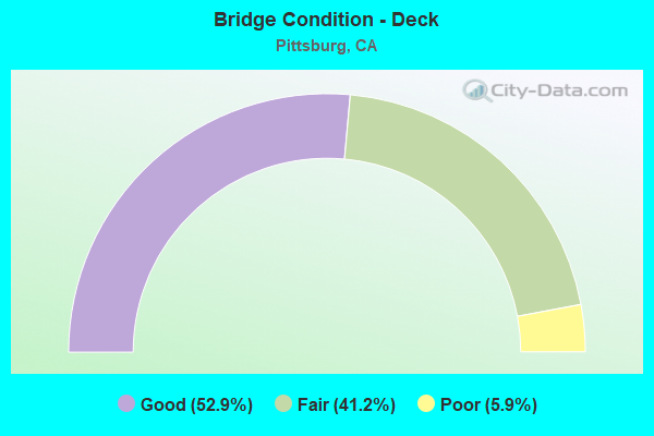
- Bridge Condition - Deck
- 52.9%Good
- 41.2%Fair
- 5.9%Poor
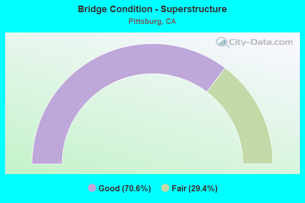
- Bridge Condition - Superstructure
- 70.6%Good
- 29.4%Fair
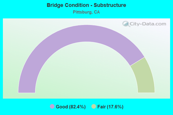
- Bridge Condition - Substructure
- 82.4%Good
- 17.6%Fair
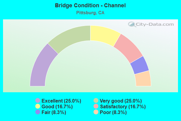
- Bridge Condition - Channel
- 25.0%Excellent
- 25.0%Very good
- 16.7%Good
- 16.7%Satisfactory
- 8.3%Fair
- 8.3%Poor
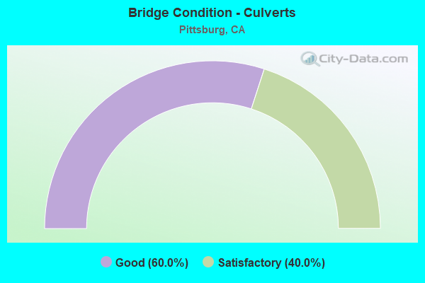
- Bridge Condition - Culverts
- 60.0%Good
- 40.0%Satisfactory
Find on map >> Show street view
Structure Number: 28 0203L, Location: 04-CC-004-R20.10 (Lat: 38.019000, Lng: -121.942289), Route carried "on" structure: State highway 4, Year Built: 1995, Status: Open, Structure Length: 4.03m (13.22ft), Average Daily Traffic: 63,500 (year 2017), Truck Traffic: 6%, Average Future Daily Traffic: 104,677 (year 2039), Design Load: HS 20+Mod, Features Intersected: BAILEY ROAD
Minimum Vertical Clearance: 30+ m (98+ ft), Kilometerpoint: 20.100, Lanes on structure: 5, Lanes under structure: 8, Base Highway Network: Yes (, Subroute: 1), Owner: State Highway Agency, Approaching Roadway Width: 24.4m (80.1ft), Material/Design: Prestressed concrete, Design/Construction: Box Beam or Girders - Multiple, Number Of Spans In Main Unit: 1, Length of Maximum Span: 39.6m (129.9ft), Curb-To-Curb Width: 24.4m (80.1ft), Out-to-Out Width: 25.5m (83.7ft)
Condition: Deck: Good, Superstructure: Good, Substructure: Fair, Operating Rating: 54.1 metric tons, Method Used To Determine Operating Rating: Assigned rating based on Load Factor Design (LFD) reported in metric tons, Inventory Rating: 32.4 metric tons, Method Used To Determine Inventory Rating: Assigned rating based on Load Factor Design (LFD) reported in metric tons, Structural Evaluation: Somewhat better than minimum adequacy, Deck Geometry: Equal to present minimum criteria, Underclear: Meets minimum limits, Approach Roadway Alignment: Equal to present desirable criteria, Designated Inspection Frequency: Every 24 months, Inspection Date: May 2021, Deck Structure Type: Concrete Cast-file-Place
Find on map >> Show street view
Structure Number: 28 0203R, Location: 04-CC-004-R20.10 (Lat: 38.018622, Lng: -121.942286), Route carried "on" structure: State highway 4, Year Built: 1994, Status: Open, Structure Length: 4.03m (13.22ft), Average Daily Traffic: 63,500 (year 2017), Truck Traffic: 6%, Average Future Daily Traffic: 104,677 (year 2039), Design Load: HS 20+Mod, Features Intersected: BAILEY ROAD
Minimum Vertical Clearance: 30+ m (98+ ft), Kilometerpoint: 20.100, Lanes on structure: 5, Lanes under structure: 8, Base Highway Network: Yes (, Subroute: 1), Owner: State Highway Agency, Approaching Roadway Width: 24.4m (80.1ft), Material/Design: Prestressed concrete, Design/Construction: Box Beam or Girders - Multiple, Number Of Spans In Main Unit: 1, Length of Maximum Span: 39.6m (129.9ft), Curb-To-Curb Width: 24.4m (80.1ft), Out-to-Out Width: 25.5m (83.7ft)
Condition: Deck: Good, Superstructure: Good, Substructure: Good, Operating Rating: 54.1 metric tons, Method Used To Determine Operating Rating: Assigned rating based on Load Factor Design (LFD) reported in metric tons, Inventory Rating: 32.4 metric tons, Method Used To Determine Inventory Rating: Assigned rating based on Load Factor Design (LFD) reported in metric tons, Structural Evaluation: Better than present minimum criteria, Deck Geometry: Equal to present minimum criteria, Underclear: Meets minimum limits, Approach Roadway Alignment: Equal to present desirable criteria, Designated Inspection Frequency: Every 24 months, Inspection Date: May 2021, Deck Structure Type: Concrete Cast-file-Place
Find on map >> Show street view
Structure Number: 28 0314L, Location: 04-CC-004-R18.76 (Lat: 38.023044, Lng: -121.966017), Route carried "on" structure: State highway 4, Year Built: 1995, Status: Open, Structure Length: 5.75m (18.86ft), Average Daily Traffic: 63,500 (year 2017), Truck Traffic: 6%, Average Future Daily Traffic: 104,677 (year 2039), Design Load: HS 20+Mod, Features Intersected: WILLOW PASS ROAD
Minimum Vertical Clearance: 30+ m (98+ ft), Kilometerpoint: 18.760, Lanes on structure: 5, Lanes under structure: 6, Base Highway Network: Yes (, Subroute: 1), Owner: State Highway Agency, Approaching Roadway Width: 27.5m (90.2ft), Material/Design: Prestressed concrete continuous, Design/Construction: Box Beam or Girders - Multiple, Number Of Spans In Main Unit: 2, Length of Maximum Span: 28.5m (93.5ft), Curb-To-Curb Width: 26.5m (86.9ft), Out-to-Out Width: 27.6m (90.6ft)
Condition: Deck: Good, Superstructure: Good, Substructure: Good, Operating Rating: 54.1 metric tons, Method Used To Determine Operating Rating: Assigned rating based on Load Factor Design (LFD) reported in metric tons, Inventory Rating: 32.4 metric tons, Method Used To Determine Inventory Rating: Assigned rating based on Load Factor Design (LFD) reported in metric tons, Structural Evaluation: Better than present minimum criteria, Deck Geometry: Superior to present desirable criteria, Underclear: Meets minimum limits, Approach Roadway Alignment: Equal to present desirable criteria, Designated Inspection Frequency: Every 24 months, Inspection Date: May 2021, Deck Structure Type: Concrete Cast-file-Place
Find on map >> Show street view
Structure Number: 28 0314R, Location: 04-CC-004-R18.76 (Lat: 38.022689, Lng: -121.966144), Route carried "on" structure: State highway 4, Year Built: 1995, Status: Open, Structure Length: 5.63m (18.47ft), Average Daily Traffic: 63,500 (year 2017), Truck Traffic: 6%, Average Future Daily Traffic: 104,677 (year 2039), Design Load: HS 20+Mod, Features Intersected: WILLOW PASS ROAD
Minimum Vertical Clearance: 30+ m (98+ ft), Kilometerpoint: 18.760, Lanes on structure: 5, Lanes under structure: 5, Base Highway Network: Yes (, Subroute: 1), Owner: State Highway Agency, Approaching Roadway Width: 25.9m (85.0ft), Material/Design: Prestressed concrete continuous, Design/Construction: Box Beam or Girders - Multiple, Number Of Spans In Main Unit: 2, Length of Maximum Span: 28.0m (91.9ft), Curb-To-Curb Width: 24.9m (81.7ft), Out-to-Out Width: 26.0m (85.3ft)
Condition: Deck: Fair, Superstructure: Good, Substructure: Fair, Operating Rating: 54.1 metric tons, Method Used To Determine Operating Rating: Assigned rating based on Load Factor Design (LFD) reported in metric tons, Inventory Rating: 32.4 metric tons, Method Used To Determine Inventory Rating: Assigned rating based on Load Factor Design (LFD) reported in metric tons, Structural Evaluation: Somewhat better than minimum adequacy, Deck Geometry: Better than present minimum criteria, Underclear: Equal to present minimum criteria, Approach Roadway Alignment: Equal to present desirable criteria, Designated Inspection Frequency: Every 24 months, Inspection Date: May 2021, Deck Structure Type: Concrete Cast-file-Place
Find on map >> Show street view
Structure Number: 28 0385, Location: 04-CC-004-23.41-PIT (Lat: 38.015744, Lng: -121.882939), Route carried "on" structure: City street , Year Built: 2003, Status: Open, Structure Length: 9.05m (29.69ft), Average Daily Traffic: 17,284 (year 2017), Truck Traffic: 8%, Average Future Daily Traffic: 21,746 (year 2039), Design Load: HS 20+Mod, Features Intersected: STATE ROUTE 4, Facility Carried by Structure: HARBOR STREET
Minimum Vertical Clearance: 30+ m (98+ ft), Kilometerpoint: 0.000, Lanes on structure: 5, Lanes under structure: 9, Owner: State Highway Agency, Approaching Roadway Width: 21.2m (69.6ft), Skew: 31 degrees, Material/Design: Prestressed concrete continuous, Design/Construction: Box Beam or Girders - Multiple, Number Of Spans In Main Unit: 2, Length of Maximum Span: 49.5m (162.4ft), Curb or Sidewalk Widths: Left: 1.5m (4.9ft), Right: 1.5m (4.9ft), Curb-To-Curb Width: 21.2m (69.6ft), Out-to-Out Width: 25.8m (84.6ft)
Condition: Deck: Good, Superstructure: Good, Substructure: Good, Operating Rating: 54.1 metric tons, Method Used To Determine Operating Rating: Assigned rating based on Load Factor Design (LFD) reported in metric tons, Inventory Rating: 32.4 metric tons, Method Used To Determine Inventory Rating: Assigned rating based on Load Factor Design (LFD) reported in metric tons, Structural Evaluation: Better than present minimum criteria, Deck Geometry: Somewhat better than minimum adequacy, Underclear: High priority of corrective action, Approach Roadway Alignment: Equal to present desirable criteria, Designated Inspection Frequency: Every 24 months, Inspection Date: May 2021, Deck Structure Type: Concrete Cast-file-Place
Find on map >> Show street view
Structure Number: 28 0386, Location: 04-CC-004-23.04-PIT (Lat: 38.017358, Lng: -121.889528), Route carried "on" structure: City street , Year Built: 2004, Status: Open, Structure Length: 8.60m (28.22ft), Average Daily Traffic: 28,000 (year 2019), Truck Traffic: 8%, Average Future Daily Traffic: 39,516 (year 2043), Design Load: HS 20+Mod, Features Intersected: STATE ROUTE 4, Facility Carried by Structure: RAILROAD AVENUE
Minimum Vertical Clearance: 30+ m (98+ ft), Kilometerpoint: 0.000, Lanes on structure: 7, Lanes under structure: 8, Base Highway Network: Yes, Owner: State Highway Agency, Approaching Roadway Width: 29.9m (98.1ft), Skew: 30 degrees, Material/Design: Prestressed concrete continuous, Design/Construction: Box Beam or Girders - Multiple, Number Of Spans In Main Unit: 2, Length of Maximum Span: 43.0m (141.1ft), Curb or Sidewalk Widths: Left: 3.0m (9.8ft), Right: 1.5m (4.9ft), Curb-To-Curb Width: 29.9m (98.1ft), Out-to-Out Width: 36.2m (118.8ft)
Condition: Deck: Fair, Superstructure: Good, Substructure: Good, Operating Rating: 54.1 metric tons, Method Used To Determine Operating Rating: Assigned rating based on Load Factor Design (LFD) reported in metric tons, Inventory Rating: 32.4 metric tons, Method Used To Determine Inventory Rating: Assigned rating based on Load Factor Design (LFD) reported in metric tons, Structural Evaluation: Better than present minimum criteria, Deck Geometry: Equal to present minimum criteria, Underclear: Meets minimum limits, Approach Roadway Alignment: Equal to present desirable criteria, Designated Inspection Frequency: Every 24 months, Inspection Date: May 2021, Deck Structure Type: Concrete Cast-file-Place
Find on map >> Show street view
Structure Number: 28 0394, Location: 04-CC-004-24.31-PIT (Lat: 38.011806, Lng: -121.867403), Route carried "on" structure: City street , Year Built: 2014, Status: Open, Structure Length: 11.81m (38.75ft), Average Daily Traffic: 23,432 (year 2017), Truck Traffic: 3%, Average Future Daily Traffic: 42,000 (year 2039), Design Load: HS 20+Mod, Features Intersected: STATE ROUTE 4, Facility Carried by Structure: LOVERIDGE ROAD
Minimum Vertical Clearance: 30+ m (98+ ft), Kilometerpoint: 0.000, Lanes on structure: 8, Lanes under structure: 9, Owner: State Highway Agency, Approaching Roadway Width: 34.7m (113.8ft), Skew: 34 degrees, Material/Design: Prestressed concrete continuous, Design/Construction: Box Beam or Girders - Multiple, Number Of Spans In Main Unit: 3, Length of Maximum Span: 44.9m (147.3ft), Curb or Sidewalk Widths: Left: 2.4m (7.9ft), Right: 2.4m (7.9ft), Curb-To-Curb Width: 34.7m (113.8ft), Out-to-Out Width: 43.0m (141.1ft)
Condition: Deck: Fair, Superstructure: Good, Substructure: Good, Operating Rating: 54.1 metric tons, Method Used To Determine Operating Rating: Assigned rating based on Load Factor Design (LFD) reported in metric tons, Inventory Rating: 32.4 metric tons, Method Used To Determine Inventory Rating: Assigned rating based on Load Factor Design (LFD) reported in metric tons, Structural Evaluation: Better than present minimum criteria, Deck Geometry: Better than present minimum criteria, Underclear: High priority of corrective action, Approach Roadway Alignment: Equal to present desirable criteria, Designated Inspection Frequency: Every 24 months, Inspection Date: May 2021, Deck Structure Type: Concrete Cast-file-Place
Find on map >> Show street view
Structure Number: 28C0034, Location: 0.8 MI S OF SH 4 (Lat: 38.001761, Lng: -122.000167), Route carried "on" structure: City street , Year Built: 1944, Status: Open, Structure Length: 32.52m (106.69ft), Average Daily Traffic: 7,200 (year 1977), Truck Traffic: 7%, Average Future Daily Traffic: 23,749 (year 2038), Design Load: HS 20, Features Intersected: MT DIABLO CRK, Facility Carried by Structure: WILLOW PASS RD
Minimum Vertical Clearance: 30+ m (98+ ft), Kilometerpoint: 0.000, Lanes on structure: 2, Lanes under structure: 2, Base Highway Network: Yes, Owner: City or Municipal Highway Agency, Approaching Roadway Width: 8.0m (26.2ft), Skew: 9 degrees, Material/Design: Concrete continuous, Design/Construction: Slab, Number Of Spans In Main Unit: 32, Length of Maximum Span: 12.2m (40.0ft), Curb or Sidewalk Widths: Left: 0.6m (2.0ft), Right: 0.6m (2.0ft), Curb-To-Curb Width: 7.9m (25.9ft), Out-to-Out Width: 9.8m (32.2ft)
Condition: Deck: Good, Superstructure: Good, Substructure: Good, Channel: Excellent, Operating Rating: 66.1 metric tons, Method Used To Determine Operating Rating: Load Factor (LF), Inventory Rating: 39.9 metric tons, Method Used To Determine Inventory Rating: Load Factor (LF), Structural Evaluation: Better than present minimum criteria, Deck Geometry: High priority of corrective action, Underclear: Meets minimum limits, Waterway Adequacy: Better than present minimum criteria, Approach Roadway Alignment: Better than present minimum criteria, Designated Inspection Frequency: Every 48 months, Inspection Date: January 2021, Deck Structure Type: Concrete Cast-file-Place, Wearing Surface/Protective System: Wearing Surface: Integral Concrete
Find on map >> Show street view
Structure Number: 28C0043, Location: 2.1 MI E I-80 IN CROCKETT (Lat: 38.049669, Lng: -122.198575), Route carried "on" structure: County highway , Year Built: 1919, Status: Open, Structure Length: 0.93m (3.05ft), Average Daily Traffic: 470 (year 2013), Truck Traffic: 6%, Average Future Daily Traffic: 1,073 (year 2037), Design Load: H 10, Features Intersected: ECKLEY SLIDE, Facility Carried by Structure: CARQUINEZ SCENIC D
Minimum Vertical Clearance: 30+ m (98+ ft), Kilometerpoint: 0.000, Lanes on structure: 2, Owner: County Highway Agency, Approaching Roadway Width: 6.4m (21.0ft), Material/Design: Concrete continuous, Design/Construction: Slab, Number Of Spans In Main Unit: 2, Length of Maximum Span: 4.6m (15.1ft), Curb-To-Curb Width: 6.4m (21.0ft), Out-to-Out Width: 7.1m (23.3ft)
Condition: Deck: Fair, Superstructure: Fair, Substructure: Fair, Channel: Good, Operating Rating: 31.4 metric tons, Method Used To Determine Operating Rating: Load Factor (LF), Inventory Rating: 18.8 metric tons, Method Used To Determine Inventory Rating: Load Factor (LF), Structural Evaluation: Somewhat better than minimum adequacy, Deck Geometry: High priority of corrective action, Waterway Adequacy: Superior to present desirable criteria, Approach Roadway Alignment: Somewhat better than minimum adequacy, Designated Inspection Frequency: Every 24 months, Inspection Date: September 2020, Deck Structure Type: Concrete Cast-file-Place, Wearing Surface/Protective System: Wearing Surface: Bituminous
Find on map >> Show street view
Structure Number: 28C0045, Location: 0.1 MI SW CENTRAL AVENUE (Lat: 38.021936, Lng: -121.880467), Route carried "on" structure: City street , Year Built: 1990, Status: Open, Structure Length: 2.71m (8.89ft), Average Daily Traffic: 3,500 (year 2016), Truck Traffic: 3%, Average Future Daily Traffic: 5,507 (year 2042), Design Load: HS 20+Mod, Features Intersected: HARBOR STREET, Facility Carried by Structure: 14TH ST
Minimum Vertical Clearance: 30+ m (98+ ft), Kilometerpoint: 0.000, Lanes on structure: 2, Lanes under structure: 4, Base Highway Network: Yes, Owner: City or Municipal Highway Agency, Approaching Roadway Width: 9.7m (31.8ft), Material/Design: Prestressed concrete, Design/Construction: Box Beam or Girders - Multiple, Number Of Spans In Main Unit: 1, Length of Maximum Span: 26.5m (86.9ft), Curb or Sidewalk Widths: Left: 1.5m (4.9ft), Right: 0.0m, Curb-To-Curb Width: 8.5m (27.9ft), Out-to-Out Width: 10.9m (35.8ft)
Condition: Deck: Fair, Superstructure: Good, Substructure: Good, Operating Rating: 54.1 metric tons, Method Used To Determine Operating Rating: Assigned rating based on Load Factor Design (LFD) reported in metric tons, Inventory Rating: 32.4 metric tons, Method Used To Determine Inventory Rating: Assigned rating based on Load Factor Design (LFD) reported in metric tons, Structural Evaluation: Better than present minimum criteria, Deck Geometry: Meets minimum limits, Underclear: High priority of corrective action, Approach Roadway Alignment: Equal to present minimum criteria, Designated Inspection Frequency: Every 24 months, Inspection Date: December 2021, Deck Structure Type: Concrete Cast-file-Place
Find on map >> Show street view
Structure Number: 28C0093, Location: 0.01 MI S STONEMAN AVE (Lat: 38.003619, Lng: -121.885014), Route carried "on" structure: City street , Year Built: 1966, Status: Open, Structure Length: 1.19m (3.90ft), Average Daily Traffic: 13,000 (year 1998), Truck Traffic: 3%, Average Future Daily Traffic: 7,633 (year 2041), Features Intersected: CONTRA COSTA CANAL, Facility Carried by Structure: HARBOR ST
Minimum Vertical Clearance: 30+ m (98+ ft), Kilometerpoint: 0.000, Lanes on structure: 4, Owner: City or Municipal Highway Agency, Approaching Roadway Width: 19.5m (64.0ft), Skew: 1 degrees, Material/Design: Concrete, Design/Construction: Tee Beam, Number Of Spans In Main Unit: 1, Length of Maximum Span: 11.3m (37.1ft), Curb or Sidewalk Widths: Left: 1.6m (5.2ft), Right: 1.6m (5.2ft), Curb-To-Curb Width: 19.5m (64.0ft), Out-to-Out Width: 23.3m (76.4ft)
Condition: Deck: Good, Superstructure: Fair, Substructure: Good, Channel: Excellent, Operating Rating: 32.4 metric tons, Method Used To Determine Operating Rating: Field evaluation and documented engineering judgment, Inventory Rating: 19.4 metric tons, Method Used To Determine Inventory Rating: Field evaluation and documented engineering judgment, Structural Evaluation: Meets minimum limits, Deck Geometry: Better than present minimum criteria, Waterway Adequacy: Superior to present desirable criteria, Approach Roadway Alignment: Equal to present minimum criteria, Designated Inspection Frequency: Every 24 months, Inspection Date: January 2021, Deck Structure Type: Concrete Cast-file-Place, Wearing Surface/Protective System: Wearing Surface: Bituminous
Find on map >> Show street view
Structure Number: 28C0132, Location: 0.7 MI S SH 4 (Lat: 38.007325, Lng: -121.892872), Route carried "on" structure: City street , Year Built: 1938, Year Reconstructed: 1995, Status: Open, Structure Length: 0.87m (2.85ft), Average Daily Traffic: 20,300 (year 1998), Truck Traffic: 5%, Average Future Daily Traffic: 43,614 (year 2041), Design Load: H 15, Features Intersected: CONTRA COSTA CANAL, Facility Carried by Structure: RAILROAD AVE
Minimum Vertical Clearance: 30+ m (98+ ft), Kilometerpoint: 0.000, Lanes on structure: 5, Base Highway Network: Yes, Owner: City or Municipal Highway Agency, Approaching Roadway Width: 19.9m (65.3ft), Skew: 30 degrees, Material/Design: Steel, Design/Construction: Stringer/Multi-beam, Number Of Spans In Main Unit: 1, Length of Maximum Span: 8.4m (27.6ft), Curb or Sidewalk Widths: Left: 1.2m (3.9ft), Right: 1.8m (5.9ft), Curb-To-Curb Width: 19.2m (63.0ft), Out-to-Out Width: 24.0m (78.7ft)
Condition: Deck: Good, Superstructure: Fair, Substructure: Good, Channel: Excellent, Operating Rating: 20.7 metric tons, Method Used To Determine Operating Rating: Load and Resistance Factor Rating (LRFR) rating reported by rating factor(RF) method using HL-93 loadings, Inventory Rating: 14.6 metric tons, Method Used To Determine Inventory Rating: Load and Resistance Factor Rating (LRFR) rating reported by rating factor(RF) method using HL-93 loadings, Structural Evaluation: High priority of corrective action, Deck Geometry: Meets minimum limits, Waterway Adequacy: Superior to present desirable criteria, Approach Roadway Alignment: Better than present minimum criteria, Designated Inspection Frequency: Every 24 months, Inspection Date: January 2021, Deck Structure Type: Concrete Cast-file-Place, Wearing Surface/Protective System: Wearing Surface: Bituminous
Find on map >> Show street view
Structure Number: 28C016, Location: 0.2 MI S SAN PABLO AVE (Lat: 37.960361, Lng: -122.346192), Route carried "on" structure: City street , Year Built: 1940, Status: Open, Structure Length: 0.72m (2.36ft), Average Daily Traffic: 13,993 (year 2010), Truck Traffic: 5%, Average Future Daily Traffic: 41,711 (year 2042), Features Intersected: WILDCAT CREEK, Facility Carried by Structure: 23RD ST
Minimum Vertical Clearance: 30+ m (98+ ft), Kilometerpoint: 0.000, Lanes on structure: 4, Base Highway Network: Yes, Owner: City or Municipal Highway Agency, Approaching Roadway Width: 19.5m (64.0ft), Skew: 3 degrees, Material/Design: Concrete continuous, Design/Construction: Culvert, Number Of Spans In Main Unit: 2, Length of Maximum Span: 3.9m (12.8ft), Curb or Sidewalk Widths: Left: 2.1m (6.9ft), Right: 2.1m (6.9ft), Curb-To-Curb Width: 19.5m (64.0ft), Out-to-Out Width: 24.4m (80.1ft)
Condition: Channel: Poor, Culverts: Good, Operating Rating: 27.2 metric tons, Method Used To Determine Operating Rating: Field evaluation and documented engineering judgment, Inventory Rating: 16.2 metric tons, Method Used To Determine Inventory Rating: Field evaluation and documented engineering judgment, Structural Evaluation: Meets minimum limits, Deck Geometry: Better than present minimum criteria, Waterway Adequacy: Equal to present minimum criteria, Approach Roadway Alignment: Better than present minimum criteria, Designated Inspection Frequency: Every 24 months, Inspection Date: December 2020, Deck Structure Type: Concrete Cast-file-Place, Wearing Surface/Protective System: Wearing Surface: Bituminous
Find on map >> Show street view
Structure Number: 28C0165, Location: OVER WILLOW PASS RD. (Lat: 38.026631, Lng: -121.918272), Route carried "on" structure: City street , Year Built: 1963, Status: Open, Structure Length: 3.26m (10.70ft), Average Daily Traffic: 12,000 (year 2020), Truck Traffic: 4%, Average Future Daily Traffic: 32,821 (year 2040), Design Load: HS 20, Features Intersected: RANGE ROAD, Facility Carried by Structure: NORTH PARKSIDE DR
Minimum Vertical Clearance: 30+ m (98+ ft), Kilometerpoint: 0.000, Lanes on structure: 2, Lanes under structure: 2, Owner: City or Municipal Highway Agency, Approaching Roadway Width: 12.0m (39.4ft), Material/Design: Steel, Design/Construction: Stringer/Multi-beam, Number Of Spans In Main Unit: 3, Length of Maximum Span: 15.8m (51.8ft), Curb or Sidewalk Widths: Left: 0.6m (2.0ft), Right: 1.7m (5.6ft), Curb-To-Curb Width: 9.6m (31.5ft), Out-to-Out Width: 12.3m (40.4ft)
Condition: Deck: Fair, Superstructure: Good, Substructure: Good, Operating Rating: 54.8 metric tons, Method Used To Determine Operating Rating: Load Factor (LF), Inventory Rating: 32.7 metric tons, Method Used To Determine Inventory Rating: Load Factor (LF), Structural Evaluation: Better than present minimum criteria, Deck Geometry: High priority of corrective action, Underclear: High priority of corrective action, Approach Roadway Alignment: Better than present minimum criteria, Designated Inspection Frequency: Every 24 months, Critical Feature Inspection Frequency: Every 24 months, Other Special Inspection Frequency: Every 48 months, Inspection Date: December 2021, Critical Feature Inspection Date: October 2020, Other Special Inspection Date: October 2020, Deck Structure Type: Concrete Cast-file-Place, Wearing Surface/Protective System: Wearing Surface: Bituminous
Find on map >> Show street view
Structure Number: 28C037, Location: AT GREEN ST (Lat: 38.016356, Lng: -122.134581), Route carried "on" structure: City street , Year Built: 1940, Status: Open, Structure Length: 1.10m (3.61ft), Average Daily Traffic: 3,000 (year 2009), Truck Traffic: 3%, Average Future Daily Traffic: 3,402 (year 2041), Features Intersected: ARROYO DEL HAMBRE, Facility Carried by Structure: FERRY STREET
Minimum Vertical Clearance: 30+ m (98+ ft), Kilometerpoint: 0.000, Lanes on structure: 2, Owner: City or Municipal Highway Agency, Approaching Roadway Width: 9.1m (29.9ft), Skew: 5 degrees, Material/Design: Concrete, Design/Construction: Tee Beam, Number Of Spans In Main Unit: 1, Length of Maximum Span: 11.0m (36.1ft), Curb or Sidewalk Widths: Left: 2.8m (9.2ft), Right: 3.0m (9.8ft), Curb-To-Curb Width: 9.1m (29.9ft), Out-to-Out Width: 15.0m (49.2ft)
Condition: Deck: Good, Superstructure: Fair, Substructure: Good, Channel: Satisfactory, Operating Rating: 25.6 metric tons, Method Used To Determine Operating Rating: Field evaluation and documented engineering judgment, Inventory Rating: 15.2 metric tons, Method Used To Determine Inventory Rating: Field evaluation and documented engineering judgment, Structural Evaluation: Meets minimum limits, Deck Geometry: Meets minimum limits, Waterway Adequacy: Equal to present minimum criteria, Approach Roadway Alignment: Equal to present minimum criteria, Designated Inspection Frequency: Every 24 months, Inspection Date: Febuary 2021, Deck Structure Type: Concrete Cast-file-Place, Wearing Surface/Protective System: Wearing Surface: Bituminous
Find on map >> Show street view
Structure Number: 28C0374, Location: AT STONEMAN AVE (Lat: 38.004731, Lng: -121.884850), Route carried "on" structure: City street , Year Built: 1968, Status: Open, Structure Length: 0.82m (2.69ft), Average Daily Traffic: 2,000 (year 2016), Truck Traffic: 4%, Average Future Daily Traffic: 8,205 (year 2040), Features Intersected: KIRKER CREEK, Facility Carried by Structure: HARBOR ST
Minimum Vertical Clearance: 30+ m (98+ ft), Kilometerpoint: 0.000, Lanes on structure: 5, Owner: City or Municipal Highway Agency, Approaching Roadway Width: 23.0m (75.5ft), Skew: 24 degrees, Material/Design: Concrete continuous, Design/Construction: Culvert, Number Of Spans In Main Unit: 2, Length of Maximum Span: 4.0m (13.1ft)
Condition: Channel: Satisfactory, Culverts: Good, Operating Rating: 40.5 metric tons, Method Used To Determine Operating Rating: Field evaluation and documented engineering judgment, Inventory Rating: 24.3 metric tons, Method Used To Determine Inventory Rating: Field evaluation and documented engineering judgment, Structural Evaluation: Equal to present minimum criteria, Waterway Adequacy: Better than present minimum criteria, Approach Roadway Alignment: Equal to present desirable criteria, Designated Inspection Frequency: Every 24 months, Inspection Date: December 2021
Find on map >> Show street view
Structure Number: 28C044, Location: AT SYCAMORE VALLEY RD (Lat: 37.813497, Lng: -121.973750), Route carried "on" structure: City street , Year Built: 1970, Status: Open, Structure Length: 0.80m (2.62ft), Average Daily Traffic: 400 (year 1983), Truck Traffic: 1%, Average Future Daily Traffic: 869 (year 2040), Features Intersected: SYCAMORE CREEK, Facility Carried by Structure: TUNBRIDGE RD
Minimum Vertical Clearance: 30+ m (98+ ft), Kilometerpoint: 0.000, Lanes on structure: 2, Owner: City or Municipal Highway Agency, Approaching Roadway Width: 12.0m (39.4ft), Material/Design: Concrete continuous, Design/Construction: Culvert, Number Of Spans In Main Unit: 2, Length of Maximum Span: 3.9m (12.8ft), Curb or Sidewalk Widths: Left: 2.7m (8.9ft), Right: 1.4m (4.6ft), Curb-To-Curb Width: 12.0m (39.4ft), Out-to-Out Width: 20.3m (66.6ft)
Condition: Channel: Good, Culverts: Satisfactory, Operating Rating: 40.5 metric tons, Method Used To Determine Operating Rating: Field evaluation and documented engineering judgment, Inventory Rating: 24.3 metric tons, Method Used To Determine Inventory Rating: Field evaluation and documented engineering judgment, Structural Evaluation: Equal to present minimum criteria, Deck Geometry: Superior to present desirable criteria, Waterway Adequacy: Somewhat better than minimum adequacy, Approach Roadway Alignment: Equal to present desirable criteria, Designated Inspection Frequency: Every 24 months, Inspection Date: March 2020, Deck Structure Type: Concrete Cast-file-Place, Wearing Surface/Protective System: Wearing Surface: Bituminous
Find on map >> Show street view
Structure Number: 28C0448, Location: 0.1 MI S OF CENTRAL AVE (Lat: 38.023483, Lng: -121.887017), Route carried "on" structure: City street , Year Built: 1988, Status: Open, Structure Length: 7.73m (25.36ft), Average Daily Traffic: 10,000 (year 2020), Truck Traffic: 5%, Average Future Daily Traffic: 16,409 (year 2040), Design Load: HS 20, Features Intersected: UP RR,PARKSIDE,RAILROAD, Facility Carried by Structure: RAILROAD AVE
Minimum Vertical Clearance: 30+ m (98+ ft), Kilometerpoint: 0.000, Lanes on structure: 5, Lanes under structure: 4, Base Highway Network: Yes, Owner: City or Municipal Highway Agency, Approaching Roadway Width: 18.0m (59.1ft), Skew: 30 degrees, Material/Design: Prestressed concrete continuous, Design/Construction: Box Beam or Girders - Multiple, Number Of Spans In Main Unit: 3, Length of Maximum Span: 27.4m (89.9ft), Curb or Sidewalk Widths: Left: 1.8m (5.9ft), Right: 1.8m (5.9ft), Curb-To-Curb Width: 20.1m (65.9ft), Out-to-Out Width: 25.6m (84.0ft)
Condition: Deck: Poor, Superstructure: Good, Substructure: Good, Operating Rating: 54.1 metric tons, Method Used To Determine Operating Rating: Assigned rating based on Load Factor Design (LFD) reported in metric tons, Inventory Rating: 32.4 metric tons, Method Used To Determine Inventory Rating: Assigned rating based on Load Factor Design (LFD) reported in metric tons, Structural Evaluation: Better than present minimum criteria, Deck Geometry: Somewhat better than minimum adequacy, Underclear: Meets minimum limits, Approach Roadway Alignment: Equal to present desirable criteria, Designated Inspection Frequency: Every 24 months, Inspection Date: December 2021, Deck Structure Type: Concrete Cast-file-Place
Find on map >> Show street view
Structure Number: 28C046, Location: AT PARR BLVD (Lat: 37.966550, Lng: -122.373558), Route carried "on" structure: County highway , Year Built: 1989, Year Reconstructed: 1994, Status: Open, Structure Length: 3.19m (10.47ft), Average Daily Traffic: 32,244 (year 2013), Truck Traffic: 5%, Average Future Daily Traffic: 31,641 (year 2037), Design Load: HS 20+Mod, Features Intersected: SAN PABLO CREEK, Facility Carried by Structure: RICHMOND PARKWAY
Minimum Vertical Clearance: 30+ m (98+ ft), Kilometerpoint: 0.000, Lanes on structure: 5, Base Highway Network: Yes, Owner: County Highway Agency, Approaching Roadway Width: 37.2m (122.0ft), Skew: 31 degrees, Material/Design: Concrete continuous, Design/Construction: Slab, Number Of Spans In Main Unit: 3, Length of Maximum Span: 10.7m (35.1ft), Curb or Sidewalk Widths: Left: 0.2m (0.7ft), Right: 0.2m (0.7ft), Curb-To-Curb Width: 36.9m (121.1ft), Out-to-Out Width: 39.8m (130.6ft)
Condition: Deck: Fair, Superstructure: Fair, Substructure: Good, Channel: Very good, Operating Rating: 54.1 metric tons, Method Used To Determine Operating Rating: Assigned rating based on Load Factor Design (LFD) reported in metric tons, Inventory Rating: 32.4 metric tons, Method Used To Determine Inventory Rating: Assigned rating based on Load Factor Design (LFD) reported in metric tons, Structural Evaluation: Somewhat better than minimum adequacy, Deck Geometry: Superior to present desirable criteria, Waterway Adequacy: Equal to present desirable criteria, Approach Roadway Alignment: Somewhat better than minimum adequacy, Designated Inspection Frequency: Every 24 months, Inspection Date: September 2020, Deck Structure Type: Concrete Cast-file-Place
Find on map >> Show street view
Structure Number: 28C0468, Location: 1.5 MI E BAILEY RD (Lat: 38.012867, Lng: -121.914519), Route carried "on" structure: City street , Year Built: 1976, Status: Open, Structure Length: 1.05m (3.44ft), Average Daily Traffic: 7,500 (year 1991), Truck Traffic: 2%, Average Future Daily Traffic: 10,976 (year 2043), Design Load: HS 20, Features Intersected: CONTRA COSTA CANAL, Facility Carried by Structure: WEST LELAND RD
Minimum Vertical Clearance: 30+ m (98+ ft), Kilometerpoint: 0.000, Lanes on structure: 4, Owner: City or Municipal Highway Agency, Approaching Roadway Width: 19.5m (64.0ft), Material/Design: Concrete, Design/Construction: Slab, Number Of Spans In Main Unit: 1, Length of Maximum Span: 9.9m (32.5ft), Curb or Sidewalk Widths: Left: 1.8m (5.9ft), Right: 1.8m (5.9ft), Curb-To-Curb Width: 19.5m (64.0ft), Out-to-Out Width: 23.8m (78.1ft)
Condition: Deck: Good, Superstructure: Good, Substructure: Good, Channel: Very good, Operating Rating: 58.3 metric tons, Method Used To Determine Operating Rating: Load Factor (LF), Inventory Rating: 35.0 metric tons, Method Used To Determine Inventory Rating: Load Factor (LF), Structural Evaluation: Better than present minimum criteria, Deck Geometry: Better than present minimum criteria, Waterway Adequacy: Equal to present desirable criteria, Approach Roadway Alignment: Equal to present minimum criteria, Designated Inspection Frequency: Every 48 months, Inspection Date: January 2021, Deck Structure Type: Concrete Cast-file-Place, Wearing Surface/Protective System: Wearing Surface: Bituminous
Find on map >> Show street view
Structure Number: 28C0496, Location: 0.6 MI E OF HARBOR ST (Lat: 38.018247, Lng: -121.869567), Route carried "on" structure: County highway , Year Built: 1950, Year Reconstructed: 2005, Status: Open, Structure Length: 0.85m (2.79ft), Average Daily Traffic: 10,610 (year 2016), Truck Traffic: 5%, Average Future Daily Traffic: 22,100 (year 2042), Features Intersected: KIRKER CREEK, Facility Carried by Structure: PITTSB-ANTIOCH HWY
Minimum Vertical Clearance: 30+ m (98+ ft), Kilometerpoint: 0.000, Lanes on structure: 2, Base Highway Network: Yes, Owner: City or Municipal Highway Agency, Approaching Roadway Width: 13.6m (44.6ft), Material/Design: Concrete continuous, Design/Construction: Culvert, Number Of Spans In Main Unit: 2, Length of Maximum Span: 4.1m (13.5ft), Curb-To-Curb Width: 13.6m (44.6ft), Out-to-Out Width: 15.2m (49.9ft)
Condition: Channel: Fair, Culverts: Satisfactory, Operating Rating: 40.5 metric tons, Method Used To Determine Operating Rating: Field evaluation and documented engineering judgment, Inventory Rating: 24.3 metric tons, Method Used To Determine Inventory Rating: Field evaluation and documented engineering judgment, Structural Evaluation: Equal to present minimum criteria, Deck Geometry: Superior to present desirable criteria, Waterway Adequacy: Equal to present desirable criteria, Approach Roadway Alignment: Equal to present desirable criteria, Designated Inspection Frequency: Every 24 months, Inspection Date: December 2021, Deck Structure Type: Concrete Cast-file-Place, Wearing Surface/Protective System: Wearing Surface: Bituminous
Find on map >> Show street view
Structure Number: 28C0497, Location: 0.6 MI E OF HARBOR ST (Lat: 38.018125, Lng: -121.868981), Route carried "on" structure: County highway , Year Built: 2005, Status: Open, Structure Length: 1.58m (5.18ft), Average Daily Traffic: 10,610 (year 2016), Truck Traffic: 5%, Average Future Daily Traffic: 22,100 (year 2042), Features Intersected: KIRKER CREEK, Facility Carried by Structure: PITTSB-ANTIOCH HWY
Minimum Vertical Clearance: 30+ m (98+ ft), Kilometerpoint: 0.000, Lanes on structure: 2, Base Highway Network: Yes, Owner: City or Municipal Highway Agency, Approaching Roadway Width: 13.6m (44.6ft), Material/Design: Steel, Design/Construction: Culvert, Number Of Spans In Main Unit: 6, Length of Maximum Span: 2.1m (6.9ft)
Condition: Channel: Very good, Culverts: Good, Operating Rating: 54.1 metric tons, Method Used To Determine Operating Rating: Field evaluation and documented engineering judgment, Inventory Rating: 32.4 metric tons, Method Used To Determine Inventory Rating: Field evaluation and documented engineering judgment, Structural Evaluation: Better than present minimum criteria, Waterway Adequacy: Equal to present desirable criteria, Approach Roadway Alignment: Equal to present desirable criteria, Designated Inspection Frequency: Every 24 months, Inspection Date: December 2021
Find on map >> Show street view
Structure Number: 28 0203L, Location: 04-CC-004-R20.10 (Lat: 38.019000, Lng: -121.942289), Route carried "under" structure: County highway , Year Built: 1995, Structure Length: 0. m, Average Daily Traffic: 15,000 (year 2017), Truck Traffic: 7%, Features Intersected: BAILEY ROAD, Facility Carried by Structure: STATE ROUTE 4 WB
Minimum Vertical Clearance: 6.13m (20.11ft), Kilometerpoint: 0.000, Lanes on structure: 5, Lanes under structure: 8, Material/Design: Prestressed concrete, Design/Construction: Box Beam or Girders - Multiple, Length of Maximum Span: 39.6m (129.9ft)
Find on map >> Show street view
Structure Number: 28 0203R, Location: 04-CC-004-R20.10 (Lat: 38.018622, Lng: -121.942286), Route carried "under" structure: County highway , Year Built: 1994, Structure Length: 0. m, Average Daily Traffic: 15,000 (year 2017), Truck Traffic: 1%, Features Intersected: BAILEY ROAD, Facility Carried by Structure: STATE ROUTE 4 EB
Minimum Vertical Clearance: 5.10m (16.73ft), Kilometerpoint: 0.000, Lanes on structure: 5, Lanes under structure: 8, Material/Design: Prestressed concrete, Design/Construction: Box Beam or Girders - Multiple, Length of Maximum Span: 39.6m (129.9ft)
Find on map >> Show street view
Structure Number: 28 0314L, Location: 04-CC-004-R18.76 (Lat: 38.023044, Lng: -121.966017), Route carried "under" structure: County highway , Year Built: 1995, Structure Length: 0. m, Average Daily Traffic: 27,237 (year 2017), Truck Traffic: 7%, Features Intersected: WILLOW PASS ROAD, Facility Carried by Structure: STATE ROUTE 4 WB
Minimum Vertical Clearance: 7.13m (23.39ft), Kilometerpoint: 0.000, Lanes on structure: 5, Lanes under structure: 6, Material/Design: Prestressed concrete continuous, Design/Construction: Box Beam or Girders - Multiple, Length of Maximum Span: 28.5m (93.5ft)
Find on map >> Show street view
Structure Number: 28 0314R, Location: 04-CC-004-R18.76 (Lat: 38.022689, Lng: -121.966144), Route carried "under" structure: County highway , Year Built: 1995, Structure Length: 0. m, Average Daily Traffic: 27,237 (year 2017), Truck Traffic: 2%, Features Intersected: WILLOW PASS ROAD, Facility Carried by Structure: STATE ROUTE 4 EB
Minimum Vertical Clearance: 5.38m (17.65ft), Kilometerpoint: 0.000, Lanes on structure: 5, Lanes under structure: 5, Material/Design: Prestressed concrete continuous, Design/Construction: Box Beam or Girders - Multiple, Length of Maximum Span: 28.0m (91.9ft)
Find on map >> Show street view
Structure Number: 28 0319R, Location: 04-CC-004-R19.96 (Lat: 38.018628, Lng: -121.945222), Route carried "under" structure: State highway 4, Year Built: 1997, Structure Length: 0. m, Average Daily Traffic: 127,000 (year 2009), Truck Traffic: 6%, Features Intersected: STATE ROUTE 4 EB, Facility Carried by Structure: PEDESTRIAN ACCESS
Minimum Vertical Clearance: 5.28m (17.32ft), Kilometerpoint: 19.960, Lanes under structure: 5, Length of Maximum Span: 27.7m (90.9ft)
Find on map >> Show street view
Structure Number: 28 0320S, Location: 04-CC-004-R19.98 (Lat: 38.018244, Lng: -121.944658), Route carried "under" structure: Ramp State highway 4, Year Built: 1997, Structure Length: 0. m, Average Daily Traffic: 5,500 (year 2017), Truck Traffic: 9%, Features Intersected: E4-BAILEY RD OFF RAMP, Facility Carried by Structure: BART ACCESS ROAD
Minimum Vertical Clearance: 5.03m (16.50ft), Kilometerpoint: 19.980, Lanes on structure: 3, Lanes under structure: 1, Material/Design: Concrete, Design/Construction: Slab, Length of Maximum Span: 12.0m (39.4ft)
Find on map >> Show street view
Structure Number: 28 0385, Location: 04-CC-004-23.41-PIT (Lat: 38.015744, Lng: -121.882939), Route carried "under" structure: State highway 4, Year Built: 2003, Structure Length: 0. m, Average Daily Traffic: 114,000 (year 2017), Truck Traffic: 8%, Features Intersected: STATE ROUTE 4, Facility Carried by Structure: HARBOR STREET
Minimum Vertical Clearance: 5.31m (17.42ft), Kilometerpoint: 23.410, Lanes on structure: 5, Lanes under structure: 9, Material/Design: Prestressed concrete continuous, Design/Construction: Box Beam or Girders - Multiple, Length of Maximum Span: 49.5m (162.4ft)
Find on map >> Show street view
Structure Number: 28 0386, Location: 04-CC-004-23.04-PIT (Lat: 38.017358, Lng: -121.889528), Route carried "under" structure: State highway 4, Year Built: 2004, Structure Length: 0. m, Average Daily Traffic: 127,000 (year 2019), Truck Traffic: 6%, Features Intersected: STATE ROUTE 4, Facility Carried by Structure: RAILROAD AVENUE
Minimum Vertical Clearance: 5.68m (18.64ft), Kilometerpoint: 23.040, Lanes on structure: 7, Lanes under structure: 8, Material/Design: Prestressed concrete continuous, Design/Construction: Box Beam or Girders - Multiple, Length of Maximum Span: 43.0m (141.1ft)
Find on map >> Show street view
Structure Number: 28 0394, Location: 04-CC-004-24.31-PIT (Lat: 38.011806, Lng: -121.867403), Route carried "under" structure: State highway 4, Year Built: 2014, Structure Length: 0. m, Average Daily Traffic: 114,000 (year 2017), Truck Traffic: 8%, Features Intersected: STATE ROUTE 4, Facility Carried by Structure: LOVERIDGE ROAD
Minimum Vertical Clearance: 5.29m (17.36ft), Kilometerpoint: 24.310, Lanes on structure: 8, Lanes under structure: 9, Material/Design: Prestressed concrete continuous, Design/Construction: Box Beam or Girders - Multiple, Length of Maximum Span: 44.9m (147.3ft)
Find on map >> Show street view
Structure Number: 28C0037, Location: 0.1 MI N OF N PARKSIDE DR (Lat: 38.027519, Lng: -121.918003), Route carried "under" structure: County highway , Year Built: 1918, Structure Length: 0. m, Average Daily Traffic: 14,099 (year 2002), Truck Traffic: 6%, Features Intersected: WILLOW PASS ROAD, Facility Carried by Structure: BNSF,AMTRAK,UP RR
Minimum Vertical Clearance: 4.60m (15.09ft), Kilometerpoint: 0.000, Lanes under structure: 2, Material/Design: Steel, Design/Construction: Stringer/Multi-beam, Length of Maximum Span: 9.4m (30.8ft)
Find on map >> Show street view
Structure Number: 28C0038, Location: 0.11 MI N/O N PARKSIDE DR (Lat: 38.027733, Lng: -121.918064), Route carried "under" structure: County highway , Year Built: 1918, Structure Length: 0. m, Average Daily Traffic: 14,099 (year 2002), Truck Traffic: 6%, Features Intersected: WILLOW PASS ROAD, Facility Carried by Structure: BNSF,AMTRAK,UP RR
Minimum Vertical Clearance: 4.70m (15.42ft), Kilometerpoint: 0.000, Lanes under structure: 2, Material/Design: Steel, Design/Construction: Stringer/Multi-beam, Length of Maximum Span: 9.4m (30.8ft)
Find on map >> Show street view
Structure Number: 28C004, Location: 0.2 MI N OF CENTRAL AVE (Lat: 38.026242, Lng: -121.881289), Route carried "under" structure: City street , Year Built: 1925, Structure Length: 0. m, Average Daily Traffic: 7,933 (year 2016), Truck Traffic: 1%, Features Intersected: SOLARI STREET, Facility Carried by Structure: BNSF RY & AMTRAK
Minimum Vertical Clearance: 4.22m (13.85ft), Kilometerpoint: 0.000, Lanes under structure: 2, Material/Design: Steel, Design/Construction: Stringer/Multi-beam, Length of Maximum Span: 9.1m (29.9ft)
Find on map >> Show street view
Structure Number: 28C0045, Location: 0.1 MI SW CENTRAL AVENUE (Lat: 38.021936, Lng: -121.880467), Route carried "under" structure: City street , Year Built: 1990, Structure Length: 0. m, Average Daily Traffic: 8,000 (year 2016), Truck Traffic: 4%, Features Intersected: HARBOR STREET, Facility Carried by Structure: 14TH ST
Minimum Vertical Clearance: 5.74m (18.83ft), Kilometerpoint: 0.000, Lanes on structure: 2, Lanes under structure: 4, Material/Design: Prestressed concrete, Design/Construction: Box Beam or Girders - Multiple, Length of Maximum Span: 26.5m (86.9ft)
Find on map >> Show street view
Structure Number: 28C0165, Location: OVER WILLOW PASS RD. (Lat: 38.026631, Lng: -121.918272), Route carried "under" structure: City street , Year Built: 1963, Structure Length: 0. m, Average Daily Traffic: 14,300 (year 2020), Truck Traffic: 4%, Features Intersected: RANGE ROAD, Facility Carried by Structure: NORTH PARKSIDE DR
Minimum Vertical Clearance: 4.79m (15.72ft), Kilometerpoint: 0.000, Lanes on structure: 2, Lanes under structure: 2, Material/Design: Steel, Design/Construction: Stringer/Multi-beam, Length of Maximum Span: 15.8m (51.8ft)
Find on map >> Show street view
Structure Number: 28C0283, Location: 0.1 MI S OF CENTRAL AVE (Lat: 38.021706, Lng: -121.880594), Route carried "under" structure: City street , Year Built: 1994, Structure Length: 0. m, Average Daily Traffic: 4,000 (year 2016), Truck Traffic: 5%, Features Intersected: HARBOR STREET, Facility Carried by Structure: UP RR
Minimum Vertical Clearance: 4.95m (16.24ft), Kilometerpoint: 0.000, Lanes under structure: 4, Material/Design: Prestressed concrete, Design/Construction: Girder and Floorbeam System, Length of Maximum Span: 12.0m (39.4ft)
Find on map >> Show street view
Structure Number: 28C0284, Location: 0.2 MI N OF CENTRAL AVE (Lat: 38.025725, Lng: -121.878919), Route carried "under" structure: City street , Year Built: 1986, Structure Length: 0. m, Average Daily Traffic: 4,000 (year 2016), Truck Traffic: 5%, Features Intersected: HARBOR STREET, Facility Carried by Structure: BNSF,UP RR,AMTRAK
Minimum Vertical Clearance: 4.94m (16.21ft), Kilometerpoint: 0.000, Lanes under structure: 4, Material/Design: Prestressed concrete, Design/Construction: Box Beam or Girders - Multiple, Length of Maximum Span: 13.7m (44.9ft)
Find on map >> Show street view
Structure Number: 28C0375, Location: 0.2 MI W OF COLUMBIA ST (Lat: 38.021603, Lng: -121.880653), Route carried "under" structure: City street , Year Built: 1940, Structure Length: 0. m, Average Daily Traffic: 21,000 (year 2016), Truck Traffic: 3%, Features Intersected: HARBOR ST, Facility Carried by Structure: PIPELINES
Minimum Vertical Clearance: 4.93m (16.17ft), Kilometerpoint: 0.000, Lanes under structure: 4, Material/Design: Steel, Length of Maximum Span: 12.0m (39.4ft)
Find on map >> Show street view
Structure Number: 28C0447, Location: 0.1 MI N OF CENTRAL AVE (Lat: 38.026497, Lng: -121.886219), Route carried "under" structure: City street , Year Built: 1988, Structure Length: 0. m, Average Daily Traffic: 10,000 (year 2020), Truck Traffic: 5%, Features Intersected: RAILROAD AVENUE, Facility Carried by Structure: BNSF RY & AMTRAK
Minimum Vertical Clearance: 4.70m (15.42ft), Kilometerpoint: 0.000, Lanes under structure: 4, Material/Design: Prestressed concrete, Design/Construction: Box Beam or Girders - Multiple, Length of Maximum Span: 20.3m (66.6ft)