Bridge Statistics for Pinconning, Michigan (MI)
Condition, Traffic, Stress, Structural Evaluation, Project Costs
- National Bridge Inventory (NBI) Statistics
- 22Number of bridges
- 75ft / 23.4mTotal length
- $1,255,000Total costs
- 91,708Total average daily traffic
- 6,568Total average daily truck traffic
- National Bridge Inventory (NBI) Registered Bridges for Pinconning
- No street view available for this location
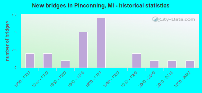
- New bridges - historical statistics
- 21930-1939
- 21940-1949
- 11950-1959
- 51960-1969
- 71970-1979
- 21990-1999
- 12000-2009
- 12010-2019
- 12020-2022

- Reconstructed bridges - Historical Statistics
- 11940-1949
- 01950-1959
- 01960-1969
- 01970-1979
- 01980-1989
- 01990-1999
- 02000-2009
- 12010-2019


- Bridge Condition - Deck
- 33.3%Good
- 11.1%Satisfactory
- 44.4%Fair
- 11.1%Poor

- Bridge Condition - Superstructure
- 44.4%Very good
- 11.1%Satisfactory
- 22.2%Fair
- 11.1%Poor
- 11.1%Critical

- Bridge Condition - Substructure
- 11.1%Very good
- 22.2%Good
- 22.2%Satisfactory
- 22.2%Fair
- 11.1%Poor
- 11.1%Serious

- Bridge Condition - Channel
- 17.6%Very good
- 17.6%Good
- 35.3%Satisfactory
- 23.5%Fair
- 5.9%Serious

- Bridge Condition - Culverts
- 11.1%Excellent
- 33.3%Good
- 11.1%Satisfactory
- 22.2%Fair
- 22.2%Poor
Find on map >> Show street view
Structure Number: 46, Location: 0.2 MI N OF KNICKBOCKER (Lat: 43.915750, Lng: -84.006111), Route carried "on" structure: County highway , Year Built: 1978, Status: Open, Structure Length: 1.58m (5.18ft), Average Daily Traffic: 53 (year 1998), Average Future Daily Traffic: 40 (year 1977), Design Load: HS 20+Mod, Features Intersected: SAGANING CREEK, Facility Carried by Structure: MELITA ROAD
Minimum Vertical Clearance: 30.48m (100.00ft), Kilometerpoint: 0.546, Lanes on structure: 2, Owner: County Highway Agency, Approaching Roadway Width: 7.9m (25.9ft), Material/Design: Wood or Timber, Design/Construction: Slab, Number Of Spans In Main Unit: 2, Length of Maximum Span: 7.9m (25.9ft), Curb-To-Curb Width: 8.5m (27.9ft), Out-to-Out Width: 9.1m (29.9ft)
Condition: Deck: Fair, Superstructure: Fair, Substructure: Satisfactory, Channel: Serious, Operating Rating: 49.2 metric tons, Method Used To Determine Operating Rating: Allowable Stress (AS) rating reported by rating factor (RF) method using MS18 loading, Inventory Rating: 35.3 metric tons, Method Used To Determine Inventory Rating: Allowable Stress (AS) rating reported by rating factor (RF) method using MS18 loading, Structural Evaluation: Somewhat better than minimum adequacy, Deck Geometry: Better than present minimum criteria, Waterway Adequacy: Better than present minimum criteria, Approach Roadway Alignment: Better than present minimum criteria, Designated Inspection Frequency: Every 12 months, Inspection Date: August 2021, Deck Structure Type: Wood or Timber, Wearing Surface/Protective System: Wearing Surface: Bituminous
Find on map >> Show street view
Structure Number: 59, Location: 3.8 MI S OF PINCONNING (Lat: 43.801669, Lng: -83.967258), Route carried "on" structure: State highway 13, Year Built: 1937, Year Reconstructed: 1951, Status: Open, Structure Length: 0.82m (2.69ft), Average Daily Traffic: 10,813 (year 2007), Truck Traffic: 5%, Average Future Daily Traffic: 11,064 (year 2018), Design Load: H 15, Features Intersected: TEBO DRAIN
Minimum Vertical Clearance: 30.48m (100.00ft), Kilometerpoint: 30.711, Lanes on structure: 4, Base Highway Network: Yes (Inventory Route: 76, Subroute: 10), Owner: State Highway Agency, Approaching Roadway Width: 24.1m (79.1ft), Skew: 20 degrees, Material/Design: Concrete, Design/Construction: Tee Beam, Number Of Spans In Main Unit: 1, Length of Maximum Span: 8.2m (26.9ft), Curb-To-Curb Width: 19.8m (65.0ft), Out-to-Out Width: 24.4m (80.1ft)
Condition: Deck: Fair, Superstructure: Satisfactory, Substructure: Fair, Channel: Very good, Operating Rating: 80.4 metric tons, Method Used To Determine Operating Rating: Load Factor (LF) rating reported by rating factor (RF) method using MS18 loading, Inventory Rating: 48.0 metric tons, Method Used To Determine Inventory Rating: Load Factor (LF) rating reported by rating factor (RF) method using MS18 loading, Structural Evaluation: Somewhat better than minimum adequacy, Deck Geometry: Better than present minimum criteria, Waterway Adequacy: Equal to present desirable criteria, Approach Roadway Alignment: Equal to present desirable criteria, Designated Inspection Frequency: Every 24 months, Other Special Inspection Frequency: Every 12 months, Inspection Date: August 2021, Other Special Inspection Date: August 2021, Deck Structure Type: Concrete Cast-file-Place, Wearing Surface/Protective System: Wearing Surface: Bituminous
Find on map >> Show street view
Structure Number: 591, Location: 1.8 MI S OF PINCONNING (Lat: 43.827319, Lng: -83.966733), Route carried "on" structure: State highway 13, Year Built: 2013, Status: Open, Structure Length: 1.83m (6.00ft), Average Daily Traffic: 11,000 (year 2012), Truck Traffic: 5%, Average Future Daily Traffic: 12,000 (year 2032), Design Load: Greater than HL93, Features Intersected: JOHNSONS CREEK
Minimum Vertical Clearance: 30.48m (100.00ft), Kilometerpoint: 33.561, Lanes on structure: 4, Base Highway Network: Yes (Inventory Route: 76, Subroute: 10), Owner: State Highway Agency, Approaching Roadway Width: 20.7m (67.9ft), Skew: 22 degrees, Material/Design: Prestressed concrete, Design/Construction: Stringer/Multi-beam, Number Of Spans In Main Unit: 1, Length of Maximum Span: 17.2m (56.4ft), Curb-To-Curb Width: 20.7m (67.9ft), Out-to-Out Width: 21.5m (70.5ft)
Condition: Deck: Good, Superstructure: Very good, Substructure: Good, Channel: Very good, Operating Rating: 64.5 metric tons, Method Used To Determine Operating Rating: Load and Resistance Factor Rating (LRFR) rating reported by rating factor(RF) method using HL-93 loadings, Inventory Rating: 39.9 metric tons, Method Used To Determine Inventory Rating: Load and Resistance Factor Rating (LRFR) rating reported by rating factor(RF) method using HL-93 loadings, Structural Evaluation: Better than present minimum criteria, Deck Geometry: Superior to present desirable criteria, Waterway Adequacy: Equal to present desirable criteria, Approach Roadway Alignment: Equal to present desirable criteria, Designated Inspection Frequency: Every 24 months, Inspection Date: May 2020, Deck Structure Type: Concrete Cast-file-Place, Wearing Surface/Protective System: Wearing Surface: Monolithic Concrete, Deck Protection: Epoxy Coated Reinforcing
Find on map >> Show street view
Structure Number: 592, Location: IN PINCONNING (Lat: 43.858319, Lng: -83.966125), Route carried "on" structure: State highway 13, Year Built: 2009, Status: Open, Structure Length: 1.52m (4.99ft), Average Daily Traffic: 9,924 (year 2007), Truck Traffic: 6%, Average Future Daily Traffic: 12,500 (year 2030), Design Load: Greater than HL93, Features Intersected: PINCONNING RIVER
Minimum Vertical Clearance: 30.48m (100.00ft), Kilometerpoint: 37.008, Lanes on structure: 4, Base Highway Network: Yes (Inventory Route: 76, Subroute: 10), Owner: State Highway Agency, Approaching Roadway Width: 15.8m (51.8ft), Material/Design: Prestressed concrete, Design/Construction: Box Beam or Girders - Single/Spread, Number Of Spans In Main Unit: 1, Length of Maximum Span: 14.4m (47.2ft), Curb or Sidewalk Widths: Left: 0.0m, Right: 2.1m (6.9ft), Curb-To-Curb Width: 15.8m (51.8ft), Out-to-Out Width: 19.1m (62.7ft)
Condition: Deck: Good, Superstructure: Very good, Substructure: Very good, Channel: Good, Operating Rating: 74.0 metric tons, Method Used To Determine Operating Rating: Load Factor (LF), Inventory Rating: 41.2 metric tons, Method Used To Determine Inventory Rating: Load Factor (LF), Structural Evaluation: Equal to present desirable criteria, Deck Geometry: Meets minimum limits, Waterway Adequacy: Better than present minimum criteria, Approach Roadway Alignment: Equal to present desirable criteria, Designated Inspection Frequency: Every 24 months, Inspection Date: April 2020, Deck Structure Type: Concrete Cast-file-Place, Wearing Surface/Protective System: Wearing Surface: Monolithic Concrete, Deck Protection: Epoxy Coated Reinforcing
Find on map >> Show street view
Structure Number: 64, Location: 3.0 MI W OF PINCONNING (Lat: 43.868333, Lng: -84.021653), Route carried "on" structure: County highway , Year Built: 1968, Year Reconstructed: 2010, Status: Open, Structure Length: 6.58m (21.59ft), Average Daily Traffic: 1,408 (year 2008), Truck Traffic: 3%, Average Future Daily Traffic: 1,620 (year 2028), Design Load: H 15, Features Intersected: I-75, Facility Carried by Structure: CODY ESTEY RD
Minimum Vertical Clearance: 30.48m (100.00ft), Kilometerpoint: 11.642, Lanes on structure: 2, Lanes under structure: 4, Owner: State Highway Agency, Approaching Roadway Width: 10.9m (35.8ft), Material/Design: Steel continuous, Design/Construction: Stringer/Multi-beam, Number Of Spans In Main Unit: 2, Length of Maximum Span: 32.6m (107.0ft), Curb-To-Curb Width: 8.7m (28.5ft), Out-to-Out Width: 9.9m (32.5ft)
Condition: Deck: Satisfactory, Superstructure: Very good, Substructure: Satisfactory, Operating Rating: 45.1 metric tons, Method Used To Determine Operating Rating: Load Factor (LF), Inventory Rating: 27.1 metric tons, Method Used To Determine Inventory Rating: Load Factor (LF), Structural Evaluation: Equal to present minimum criteria, Deck Geometry: Somewhat better than minimum adequacy, Underclear: Somewhat better than minimum adequacy, Approach Roadway Alignment: Somewhat better than minimum adequacy, Designated Inspection Frequency: Every 24 months, Inspection Date: September 2020, Deck Structure Type: Concrete Cast-file-Place, Wearing Surface/Protective System: Wearing Surface: Latex Concrete
Find on map >> Show street view
Structure Number: 69, Location: 100 FT N OF COGGINS RD (Lat: 43.801972, Lng: -83.962358), Route carried "on" structure: County highway , Year Built: 2021, Status: Open, Structure Length: 0.82m (2.69ft), Average Daily Traffic: 271 (year 2000), Average Future Daily Traffic: 325 (year 2020), Design Load: HL 93, Features Intersected: TEBO DRAIN, Facility Carried by Structure: KAISER TOWER ROAD
Minimum Vertical Clearance: 30.48m (100.00ft), Kilometerpoint: 0.100, Lanes on structure: 2, Owner: County Highway Agency, Approaching Roadway Width: 12.2m (40.0ft), Material/Design: Concrete, Design/Construction: Culvert, Number Of Spans In Main Unit: 1, Length of Maximum Span: 7.6m (24.9ft)
Condition: Channel: Very good, Culverts: Excellent, Operating Rating: 90.4 metric tons, Method Used To Determine Operating Rating: Load and Resistance Factor Rating (LRFR) rating reported by rating factor(RF) method using HL-93 loadings, Inventory Rating: 69.7 metric tons, Method Used To Determine Inventory Rating: Load and Resistance Factor Rating (LRFR) rating reported by rating factor(RF) method using HL-93 loadings, Structural Evaluation: Superior to present desirable criteria, Waterway Adequacy: Equal to present desirable criteria, Approach Roadway Alignment: Equal to present desirable criteria, Designated Inspection Frequency: Every 24 months, Inspection Date: June 2021, Deck Structure Type: Concrete Precast Panels, Wearing Surface/Protective System: Wearing Surface: Bituminous
Find on map >> Show street view
Structure Number: 704, Location: 1000 FT N OF NEUMAN RD (Lat: 43.844192, Lng: -84.026147), Route carried "on" structure: County highway 929, Year Built: 1992, Status: Open, Structure Length: 0.74m (2.43ft), Average Daily Traffic: 1,778 (year 2000), Truck Traffic: 7%, Average Future Daily Traffic: 2,844 (year 2020), Design Load: HS 20+Mod, Features Intersected: PINCONNING RIVER, Facility Carried by Structure: SEVEN MILE ROAD
Minimum Vertical Clearance: 30.48m (100.00ft), Kilometerpoint: 35.602, Lanes on structure: 2, Owner: County Highway Agency, Approaching Roadway Width: 11.0m (36.1ft), Material/Design: Concrete, Design/Construction: Culvert, Number Of Spans In Main Unit: 1, Length of Maximum Span: 6.7m (22.0ft)
Condition: Channel: Satisfactory, Culverts: Good, Operating Rating: 32.7 metric tons, Method Used To Determine Operating Rating: Field evaluation and documented engineering judgment, Inventory Rating: 19.6 metric tons, Method Used To Determine Inventory Rating: Field evaluation and documented engineering judgment, Structural Evaluation: Somewhat better than minimum adequacy, Waterway Adequacy: Equal to present desirable criteria, Approach Roadway Alignment: Equal to present desirable criteria, Designated Inspection Frequency: Every 24 months, Inspection Date: April 2020, Deck Structure Type: Concrete Cast-file-Place, Wearing Surface/Protective System: Wearing Surface: Bituminous
Find on map >> Show street view
Structure Number: 709, Location: 600 FT S WHITEFEATHER RD (Lat: 43.894992, Lng: -83.985894), Route carried "on" structure: County highway , Year Built: 1937, Status: Posted for load, Structure Length: 0.73m (2.40ft), Average Daily Traffic: 274 (year 2000), Truck Traffic: 2%, Average Future Daily Traffic: 438 (year 2020), Design Load: H 15, Features Intersected: WHITEFEATHER DRAIN, Facility Carried by Structure: MACKINAW RD
Minimum Vertical Clearance: 30.48m (100.00ft), Kilometerpoint: 41.333, Lanes on structure: 2, Owner: County Highway Agency, Approaching Roadway Width: 9.8m (32.2ft), Material/Design: Steel, Design/Construction: Stringer/Multi-beam, Number Of Spans In Main Unit: 1, Length of Maximum Span: 6.1m (20.0ft), Curb-To-Curb Width: 8.2m (26.9ft), Out-to-Out Width: 9.2m (30.2ft)
Condition: Deck: Poor, Superstructure: Critical, Substructure: Serious, Channel: Fair, Operating Rating: 4.2 metric tons, Method Used To Determine Operating Rating: Load Factor (LF) rating reported by rating factor (RF) method using MS18 loading, Inventory Rating: 2.6 metric tons, Method Used To Determine Inventory Rating: Load Factor (LF) rating reported by rating factor (RF) method using MS18 loading, Structural Evaluation: High priority of replacement, Deck Geometry: Somewhat better than minimum adequacy, Waterway Adequacy: Equal to present minimum criteria, Approach Roadway Alignment: Equal to present desirable criteria, Bridge Posting: Required (Relationship of Operating Rating to Maximum Legal Load: > 39.9% below), Length Of Structure Improvement: 0.91m (2.99ft), Designated Inspection Frequency: Every 12 months, Inspection Date: April 2021, Bridge Improvement Cost: $137,000, Roadway Improvement Cost: $8,000, Total Project Cost: $145,000, Deck Structure Type: Concrete Cast-file-Place, Wearing Surface/Protective System: Wearing Surface: Bituminous
Find on map >> Show street view
Structure Number: 723, Location: 300 FT N OF COGGINS RD (Lat: 43.804042, Lng: -83.957506), Route carried "on" structure: County highway , Year Built: 1948, Status: Posted for load, Structure Length: 0.91m (2.99ft), Average Daily Traffic: 75 (year 2000), Truck Traffic: 5%, Average Future Daily Traffic: 90 (year 2020), Design Load: HS 20+Mod, Features Intersected: TEBO DRAIN, Facility Carried by Structure: AUSABLE STATE ROAD
Minimum Vertical Clearance: 30.48m (100.00ft), Kilometerpoint: 0.079, Lanes on structure: 2, Owner: County Highway Agency, Approaching Roadway Width: 7.9m (25.9ft), Material/Design: Steel, Design/Construction: Stringer/Multi-beam, Number Of Spans In Main Unit: 1, Length of Maximum Span: 8.5m (27.9ft), Curb-To-Curb Width: 6.1m (20.0ft), Out-to-Out Width: 6.8m (22.3ft)
Condition: Deck: Fair, Superstructure: Fair, Substructure: Fair, Channel: Satisfactory, Operating Rating: 9.5 metric tons, Method Used To Determine Operating Rating: Load Factor (LF), Inventory Rating: 5.7 metric tons, Method Used To Determine Inventory Rating: Load Factor (LF), Structural Evaluation: High priority of replacement, Deck Geometry: Somewhat better than minimum adequacy, Waterway Adequacy: Equal to present minimum criteria, Approach Roadway Alignment: Somewhat better than minimum adequacy, Bridge Posting: Required (Relationship of Operating Rating to Maximum Legal Load: > 39.9% below), Length Of Structure Improvement: 1.50m (4.92ft), Designated Inspection Frequency: Every 12 months, Inspection Date: April 2021, Bridge Improvement Cost: $257,000, Roadway Improvement Cost: $70,000, Total Project Cost: $350,000, Deck Structure Type: Concrete Cast-file-Place, Wearing Surface/Protective System: Wearing Surface: Bituminous
Find on map >> Show street view
Structure Number: 724, Location: 200 FT N OF ALMEDA BEACH (Lat: 43.818050, Lng: -83.947019), Route carried "on" structure: County highway , Year Built: 1975, Status: Open, Structure Length: 0.73m (2.40ft), Average Daily Traffic: 457 (year 1997), Truck Traffic: 10%, Average Future Daily Traffic: 752 (year 2018), Design Load: HS 20+Mod, Features Intersected: JOHNSONS CREEK, Facility Carried by Structure: TOWER BEACH ROAD
Minimum Vertical Clearance: 30.48m (100.00ft), Kilometerpoint: 4.030, Lanes on structure: 2, Owner: County Highway Agency, Approaching Roadway Width: 9.1m (29.9ft), Material/Design: Concrete, Design/Construction: Culvert, Number Of Spans In Main Unit: 2, Length of Maximum Span: 3.0m (9.8ft)
Condition: Channel: Fair, Culverts: Satisfactory, Operating Rating: 32.7 metric tons, Method Used To Determine Operating Rating: Field evaluation and documented engineering judgment, Inventory Rating: 19.6 metric tons, Method Used To Determine Inventory Rating: Field evaluation and documented engineering judgment, Structural Evaluation: Somewhat better than minimum adequacy, Waterway Adequacy: Equal to present desirable criteria, Approach Roadway Alignment: Equal to present desirable criteria, Designated Inspection Frequency: Every 24 months, Inspection Date: April 2020, Deck Structure Type: Concrete Precast Panels, Wearing Surface/Protective System: Wearing Surface: Bituminous
Find on map >> Show street view
Structure Number: 725, Location: AT COGGINS RD (Lat: 43.803392, Lng: -83.947333), Route carried "on" structure: County highway , Year Built: 1972, Status: Open, Structure Length: 0.97m (3.18ft), Average Daily Traffic: 470 (year 2000), Truck Traffic: 10%, Average Future Daily Traffic: 564 (year 2020), Design Load: HS 20+Mod, Features Intersected: TEBO DRAIN, Facility Carried by Structure: TOWER BEACH ROAD
Minimum Vertical Clearance: 30.48m (100.00ft), Kilometerpoint: 2.401, Lanes on structure: 2, Owner: County Highway Agency, Approaching Roadway Width: 9.1m (29.9ft), Material/Design: Concrete, Design/Construction: Culvert, Number Of Spans In Main Unit: 2, Length of Maximum Span: 4.2m (13.8ft)
Condition: Channel: Satisfactory, Culverts: Fair, Operating Rating: 32.7 metric tons, Method Used To Determine Operating Rating: Field evaluation and documented engineering judgment, Inventory Rating: 19.6 metric tons, Method Used To Determine Inventory Rating: Field evaluation and documented engineering judgment, Structural Evaluation: Somewhat better than minimum adequacy, Waterway Adequacy: Equal to present desirable criteria, Approach Roadway Alignment: Equal to present desirable criteria, Designated Inspection Frequency: Every 24 months, Inspection Date: April 2020, Deck Structure Type: Concrete Precast Panels, Wearing Surface/Protective System: Wearing Surface: Bituminous
Find on map >> Show street view
Structure Number: 742, Location: 0.3 MI N OF PINCONNING RD (Lat: 43.856694, Lng: -83.948042), Route carried "on" structure: County highway , Year Built: 1945, Status: Posted for load, Structure Length: 1.25m (4.10ft), Average Daily Traffic: 75 (year 2000), Truck Traffic: 1%, Average Future Daily Traffic: 90 (year 2020), Design Load: H 15, Features Intersected: PINCONNING RIVER, Facility Carried by Structure: HUNTER ROAD
Minimum Vertical Clearance: 30.48m (100.00ft), Kilometerpoint: 0.497, Lanes on structure: 2, Owner: County Highway Agency, Approaching Roadway Width: 6.1m (20.0ft), Material/Design: Steel, Design/Construction: Stringer/Multi-beam, Number Of Spans In Main Unit: 1, Length of Maximum Span: 11.5m (37.7ft), Curb-To-Curb Width: 7.0m (23.0ft), Out-to-Out Width: 7.3m (24.0ft)
Condition: Deck: Fair, Superstructure: Poor, Substructure: Poor, Channel: Satisfactory, Operating Rating: 23.5 metric tons, Method Used To Determine Operating Rating: Load Factor (LF), Inventory Rating: 14.1 metric tons, Method Used To Determine Inventory Rating: Load Factor (LF), Structural Evaluation: Meets minimum limits, Deck Geometry: Somewhat better than minimum adequacy, Waterway Adequacy: Equal to present minimum criteria, Approach Roadway Alignment: Meets minimum limits, Bridge Posting: Required (Relationship of Operating Rating to Maximum Legal Load: > 39.9% below), Length Of Structure Improvement: 1.90m (6.23ft), Designated Inspection Frequency: Every 12 months, Inspection Date: May 2021, Bridge Improvement Cost: $320,000, Roadway Improvement Cost: $70,000, Total Project Cost: $410,000, Deck Structure Type: Concrete Cast-file-Place, Wearing Surface/Protective System: Wearing Surface: Monolithic Concrete
Find on map >> Show street view
Structure Number: 744, Location: 200 FT N OF RASHOTT RD (Lat: 43.903986, Lng: -83.912186), Route carried "on" structure: County highway , Year Built: 1955, Status: Posted for load, Structure Length: 0.79m (2.59ft), Average Daily Traffic: 122 (year 2000), Truck Traffic: 1%, Average Future Daily Traffic: 146 (year 2020), Design Load: H 15, Features Intersected: PRIVATE CHANNEL, Facility Carried by Structure: AVALON ROAD
Minimum Vertical Clearance: 30.48m (100.00ft), Kilometerpoint: 0.076, Lanes on structure: 2, Owner: County Highway Agency, Approaching Roadway Width: 7.0m (23.0ft), Material/Design: Steel, Design/Construction: Culvert, Number Of Spans In Main Unit: 1, Length of Maximum Span: 7.3m (24.0ft)
Condition: Channel: Good, Culverts: Poor, Operating Rating: 5.8 metric tons, Method Used To Determine Operating Rating: Load Factor (LF) rating reported by rating factor (RF) method using MS18 loading, Inventory Rating: 3.6 metric tons, Method Used To Determine Inventory Rating: Load Factor (LF) rating reported by rating factor (RF) method using MS18 loading, Structural Evaluation: High priority of replacement, Waterway Adequacy: Equal to present minimum criteria, Approach Roadway Alignment: Meets minimum limits, Bridge Posting: Required (Relationship of Operating Rating to Maximum Legal Load: > 39.9% below), Length Of Structure Improvement: 1.35m (4.43ft), Designated Inspection Frequency: Every 12 months, Underwater Inspection Frequency: Every 60 months, Inspection Date: April 2021, Underwater Inspection Date: May 2018, Bridge Improvement Cost: $225,000, Roadway Improvement Cost: $100,000, Total Project Cost: $350,000, Wearing Surface/Protective System: Wearing Surface: Bituminous
Find on map >> Show street view
Structure Number: 751, Location: 1100 FT S OF CITY LIMITS (Lat: 43.860811, Lng: -83.959444), Route carried "on" structure: City street , Year Built: 1996, Status: Open, Structure Length: 1.40m (4.59ft), Average Daily Traffic: 1,109 (year 1995), Truck Traffic: 25%, Average Future Daily Traffic: 3,500 (year 2018), Design Load: HS 25 or greater, Features Intersected: PINCONNING RIVER, Facility Carried by Structure: WATER STREET
Minimum Vertical Clearance: 30.48m (100.00ft), Kilometerpoint: 0.837, Lanes on structure: 2, Owner: City or Municipal Highway Agency, Approaching Roadway Width: 8.5m (27.9ft), Skew: 1 degrees, Material/Design: Prestressed concrete, Design/Construction: Box Beam or Girders - Multiple, Number Of Spans In Main Unit: 1, Length of Maximum Span: 13.2m (43.3ft), Curb or Sidewalk Widths: Left: 1.7m (5.6ft), Right: 1.7m (5.6ft), Curb-To-Curb Width: 9.1m (29.9ft), Out-to-Out Width: 13.4m (44.0ft)
Condition: Deck: Good, Superstructure: Very good, Substructure: Good, Channel: Good, Operating Rating: 81.9 metric tons, Method Used To Determine Operating Rating: Load Factor (LF), Inventory Rating: 44.7 metric tons, Method Used To Determine Inventory Rating: Load Factor (LF), Structural Evaluation: Better than present minimum criteria, Deck Geometry: Somewhat better than minimum adequacy, Waterway Adequacy: Equal to present minimum criteria, Approach Roadway Alignment: Equal to present desirable criteria, Designated Inspection Frequency: Every 24 months, Inspection Date: August 2021, Deck Structure Type: Concrete Cast-file-Place, Wearing Surface/Protective System: Wearing Surface: Monolithic Concrete, Deck Protection: Epoxy Coated Reinforcing
Find on map >> Show street view
Structure Number: 13119, Location: 0.5 MI S OF MT FOREST RD (Lat: 43.878039, Lng: -83.985989), Route carried "on" structure: County highway , Year Built: 1975, Status: Open, Structure Length: 0.68m (2.23ft), Average Daily Traffic: 335 (year 2002), Average Future Daily Traffic: 345 (year 2020), Design Load: HS 20, Features Intersected: SELLECK DRAIN, Facility Carried by Structure: MACKINAW ROAD
Minimum Vertical Clearance: 30.48m (100.00ft), Kilometerpoint: 39.450, Lanes on structure: 2, Owner: County Highway Agency, Approaching Roadway Width: 6.7m (22.0ft), Skew: 3 degrees, Material/Design: Steel, Design/Construction: Culvert, Number Of Spans In Main Unit: 2, Length of Maximum Span: 3.3m (10.8ft)
Condition: Channel: Satisfactory, Culverts: Fair, Operating Rating: 92.0 metric tons, Method Used To Determine Operating Rating: Load Factor (LF) rating reported by rating factor (RF) method using MS18 loading, Inventory Rating: 91.7 metric tons, Method Used To Determine Inventory Rating: Load Factor (LF) rating reported by rating factor (RF) method using MS18 loading, Structural Evaluation: Somewhat better than minimum adequacy, Waterway Adequacy: Equal to present desirable criteria, Approach Roadway Alignment: Equal to present desirable criteria, Designated Inspection Frequency: Every 24 months, Inspection Date: April 2020, Wearing Surface/Protective System: Wearing Surface: Bituminous
Find on map >> Show street view
Structure Number: 13123, Location: 0.25 MI S OF WHITEFEATHER (Lat: 43.892322, Lng: -84.005942), Route carried "on" structure: County highway , Year Built: 1970, Status: Posted for load, Structure Length: 0.79m (2.59ft), Average Daily Traffic: 150 (year 1998), Average Future Daily Traffic: 173 (year 2018), Design Load: HS 20, Features Intersected: WHITEFEATHER CREEK, Facility Carried by Structure: FRASER ROAD
Minimum Vertical Clearance: 30.48m (100.00ft), Kilometerpoint: 24.976, Lanes on structure: 2, Owner: County Highway Agency, Approaching Roadway Width: 4.3m (14.1ft), Material/Design: Steel, Design/Construction: Culvert, Number Of Spans In Main Unit: 2, Length of Maximum Span: 3.8m (12.5ft)
Condition: Channel: Satisfactory, Culverts: Poor, Operating Rating: 41.1 metric tons, Method Used To Determine Operating Rating: Load Factor (LF) rating reported by rating factor (RF) method using MS18 loading, Inventory Rating: 24.6 metric tons, Method Used To Determine Inventory Rating: Load Factor (LF) rating reported by rating factor (RF) method using MS18 loading, Structural Evaluation: Meets minimum limits, Waterway Adequacy: Better than present minimum criteria, Approach Roadway Alignment: Equal to present desirable criteria, Bridge Posting: Required (Relationship of Operating Rating to Maximum Legal Load: > 39.9% below), Designated Inspection Frequency: Every 12 months, Inspection Date: April 2021, Wearing Surface/Protective System: Wearing Surface: Bituminous
Find on map >> Show street view
Structure Number: 13982, Location: 0.26 MI W OF M-13 (Lat: 43.825000, Lng: -83.972194), Route carried "on" structure: County highway , Year Built: 1972, Status: Open, Structure Length: 0.65m (2.13ft), Average Daily Traffic: 50 (year 2017), Average Future Daily Traffic: 100 (year 2037), Features Intersected: JOHNSON CREEK, Facility Carried by Structure: TOWNLINE 16 ROAD
Minimum Vertical Clearance: 30.48m (100.00ft), Kilometerpoint: 3.087, Lanes on structure: 2, Owner: County Highway Agency, Approaching Roadway Width: 5.5m (18.0ft), Material/Design: Concrete, Design/Construction: Culvert, Number Of Spans In Main Unit: 2, Length of Maximum Span: 3.0m (9.8ft)
Condition: Channel: Fair, Culverts: Good, Operating Rating: 54.5 metric tons, Method Used To Determine Operating Rating: Field evaluation and documented engineering judgment, Inventory Rating: 32.7 metric tons, Method Used To Determine Inventory Rating: Field evaluation and documented engineering judgment, Structural Evaluation: Better than present minimum criteria, Waterway Adequacy: Better than present minimum criteria, Approach Roadway Alignment: Equal to present desirable criteria, Designated Inspection Frequency: Every 24 months, Inspection Date: May 2021, Wearing Surface/Protective System: Wearing Surface: Bituminous
Find on map >> Show street view
Structure Number: 13983, Location: 0.8 MI N OF ALMEDA BEACH (Lat: 43.829194, Lng: -83.961694), Route carried "on" structure: County highway , Year Built: 1970, Status: Open, Structure Length: 0.65m (2.13ft), Average Daily Traffic: 50 (year 2017), Average Future Daily Traffic: 100 (year 2037), Features Intersected: JOHNSON DRAIN, Facility Carried by Structure: KAISER ROAD
Minimum Vertical Clearance: 30.48m (100.00ft), Kilometerpoint: 3.087, Lanes on structure: 2, Owner: County Highway Agency, Approaching Roadway Width: 6.9m (22.6ft), Material/Design: Concrete, Design/Construction: Culvert, Number Of Spans In Main Unit: 2, Length of Maximum Span: 3.0m (9.8ft)
Condition: Channel: Fair, Culverts: Good, Operating Rating: 54.5 metric tons, Method Used To Determine Operating Rating: Field evaluation and documented engineering judgment, Inventory Rating: 32.7 metric tons, Method Used To Determine Inventory Rating: Field evaluation and documented engineering judgment, Structural Evaluation: Better than present minimum criteria, Waterway Adequacy: Better than present minimum criteria, Approach Roadway Alignment: Better than present minimum criteria, Designated Inspection Frequency: Every 24 months, Inspection Date: May 2021, Wearing Surface/Protective System: Wearing Surface: Bituminous
Find on map >> Show street view
Structure Number: 639, Location: 2.7 MI W OF PINCONNING (Lat: 43.853992, Lng: -84.020333), Route carried "under" structure: Interstate 75, Year Built: 1968, Structure Length: 0. m, Average Daily Traffic: 31,044 (year 2007), Truck Traffic: 9%, Features Intersected: I-75, Facility Carried by Structure: PINCONNING RD
Minimum Vertical Clearance: 5.08m (16.67ft), Kilometerpoint: 39.160, Lanes on structure: 2, Lanes under structure: 4, Material/Design: Steel continuous, Design/Construction: Stringer/Multi-beam, Length of Maximum Span: 32.5m (106.6ft)
Find on map >> Show street view
Structure Number: 64, Location: 3.0 MI W OF PINCONNING (Lat: 43.868333, Lng: -84.021653), Route carried "under" structure: Interstate 75, Year Built: 1968, Structure Length: 0. m, Average Daily Traffic: 21,500 (year 2010), Truck Traffic: 7%, Features Intersected: I-75, Facility Carried by Structure: CODY ESTEY RD
Minimum Vertical Clearance: 5.03m (16.50ft), Kilometerpoint: 40.761, Lanes on structure: 2, Lanes under structure: 4, Material/Design: Steel continuous, Design/Construction: Stringer/Multi-beam, Length of Maximum Span: 32.6m (107.0ft)
Find on map >> Show street view
Structure Number: 641, Location: 3.0 MI N OF PINCONNING (Lat: 43.897033, Lng: -84.020328), Route carried "under" structure: County highway , Year Built: 1968, Structure Length: 0. m, Average Daily Traffic: 375 (year 1995), Truck Traffic: 3%, Features Intersected: WHITE FEATHER ROAD, Facility Carried by Structure: I-75 SB
Minimum Vertical Clearance: 4.29m (14.07ft), Kilometerpoint: 3.571, Lanes on structure: 2, Lanes under structure: 2, Material/Design: Prestressed concrete, Design/Construction: Stringer/Multi-beam, Length of Maximum Span: 12.8m (42.0ft)
Find on map >> Show street view
Structure Number: 643, Location: 3.0 MI N OF PINCONNING (Lat: 43.897031, Lng: -84.019861), Route carried "under" structure: County highway , Year Built: 1968, Structure Length: 0. m, Average Daily Traffic: 375 (year 1995), Truck Traffic: 8%, Features Intersected: WHITE FEATHER ROAD, Facility Carried by Structure: I-75 NB
Minimum Vertical Clearance: 4.32m (14.17ft), Kilometerpoint: 3.608, Lanes on structure: 2, Lanes under structure: 2, Material/Design: Prestressed concrete, Design/Construction: Stringer/Multi-beam, Length of Maximum Span: 12.8m (42.0ft)